Kansas Geological Survey, Bulletin 52, part 5, originally published in 1944
Originally published in 1944 as Kansas Geological Survey Bulletin 52, part 5. This is, in general, the original text as published. The information has not been updated. An Acrobat PDF version of this report is available (4 MB). Plate available separately.
The Weir-Pittsburg coal bed crops out in a narrow belt across the southeastern corner of Kansas. From the eastern limit of its outcrop it has been mined by stripping methods in areas where the overburden was less than 50 feet. The area of deep mines or shafts extends westward from the stripped areas for a distance of about 5 or 6 miles. The depth to the coal bed in the regions worked by the deep mines ranges from 25 to 285 feet. The Weir-Pittsburg coal bed lies near the middle of the Cherokee shale; however, the interval between the top of the Cherokee and the coal bed is not constant but ranges from 165 to 225 feet. The thickness of the coal bed ranges from 32 to 43 inches.
Large areas of coal have not yet been worked, but in most cases the unworked coal is in the deeper part of the field.
During the fuel shortage of 1942, numerous inquiries concerning the unmined areas of coal in the Weir-Pittsburg coal bed were directed to the Geological Survey. At the request of officials of the coal-mining companies, a map showing location of the active mines and the old mine workings was prepared. This map was used in a report to the Federal Government to indicate favorable locations for deep mechanized mines. Mine regions worked since 1942 and some corrections and additions to the original map have been incorporated in the map of the worked areas of the Weir-Pittsburg coal bed that accompanies this report.
This opportunity is taken to thank officials of coal-mining companies that have operated or are operating in -the field; particularly those of the Pittsburg and Midway Coal Mining Company, the Central Coal and Coke Company, and the Western Coal and Mining Company for access to their drill records and mine maps. The Mackie-Clemens Coal Company; the Commercial Fuel Company, and the Klaner Coal Company also furnished valuable information. The St. Louis-San Francisco Railway Company furnished a number of maps. Data and maps in the State Mine Inspector's office were used freely in compiling the map of the worked areas of the Weir-Pittsburg coal bed. The manuscript was critically read by John C. Frye, Acting State Geologist.
The first detailed report published on Kansas coal is by Haworth and Crane (1898). A large part of this report deals with the Weir-Pittsburg bed in southeastern Kansas. More recent reports which contain information on the Weir-Pittsburg coal bed are by Young and Allen (1925), Moore and Landes (1927), and Pierce and Courtier (1937). In 1936 Abernathy, in a thesis submitted to the University of Kansas, discussed the Cherokee rocks in southeastern Kansas and the relation of the Weir-Pittsburg and other beds to the cyclothems in the Cherokee section. A chapter on coal is included in a report on "Kansas mineral resources for wartime industries" (Jewett and Schoewe, 1942, pp. 77-88).
The location of the worked area of the Weir-Pittsburg coal bed is shown in Plate 1. The area that has been worked in southeastern Kansas is an irregularly shaped, elliptical area extending from northeast to southwest from the vicinity of Arcadia through eastern Crawford and northern Cherokee counties. The line of outcrop of the coal bed passes from a point near Arcadia southward along the Kansas-Missouri boundary to a point east of Pittsburg, then westward to the southeastern area of Pittsburg, and then southwestward though a point about 5 miles south of Scammon.
The area of active mining and the mined-out areas of the Weir-Pittsburg coal bed comprise a broad, relatively level erosional plane that truncates the outcropping edges of the soft easily eroded beds of sand, sandy shale, and coal of the Cherokee shale. The surface of the ground slopes to the west at an average rate of about 10 feet to the mile in the worked areas of the Weir-Pittsburg coal bed. Farther west the surface rises to the escarpment of the resistant members of the Fort Scott limestone.
The early history of the development of the Weir-Pittsburg coal bed is not well recorded. The earliest record of its mining (Haworth, 1898) indicates that coal was mined sometime between 1850 and 1860. In 1866, coal was obtained from the outcrop of the Weir-Pittsburg bed in Cherokee county and hauled by wagon to Granby, Missouri, where it was used as blacksmith coal.
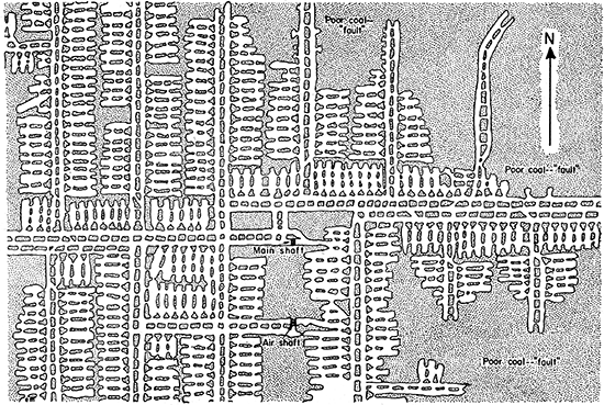
The earliest operations were in strip mines or wagon-pit mines along the banks of creeks. Strip mining was done in this district before the Civil War. The thin overburden was removed by horses and scrapers, and the coal was loaded by hand into wagons. The first railroad to be built in the district was the Missouri River, Fort Scott and Gulf Railroad (later the Kansas City, Fort Scott and Memphis and now the Saint Louis and San Francisco), which was completed to Baxter Springs in 1870. Four years later the first shaft mine was opened by Scammon Brothers near the present town of Scammon. In the early history of the district, coal was hoisted from the mines by a horse "whim." Later, steam hoists were used in the larger mines, and gasoline engines were used in the smaller mines. More recently, electric hoists have replaced all of the steam hoists and most of the gasoline hoists. The room and pillar system is used in the deep mines. Figure 1 illustrates this system of mining, and shows the average size of mine workings and room pillars.
Figure 1--Section of a mine map showing room and pillar system of mining and ratio of faulty coal areas to mined areas.
Railroad contractors soon became interested in the problem of removing the overburden by mechanical means. In 1877, the Hoges-Armil Coal Company began using a steam shovel to remove the overburden from the Weir-Pittsburg coal bed near Pittsburg. This was the first use of a steam shovel in strip coal mining in the United States. The first revolving shovel in this area was used in 1905; it had a 2-yard dipper and was designed to remove 15 feet of overburden. Larger shovels with 3-yard, dippers were used in this field in 1911. Shovels having a boom 75 feet long and a dipper of 6 cubic yards capacity were in common use in 1915. There has been a gradual increase in the size of shovels between 1920 and the present time. The largest shovel now in operation has a boom 90 feet long and is capable of stripping to a depth of 50 feet or more; the capacity of the dipper is 30 cubic yards.
The Cherokee shale is the lowest division of the Pennsylvanian system in Crawford and Cherokee counties, Kansas. It rests unconformably upon the uneven surface of rocks belonging to the Mississippian system.
The Cherokee shale includes all of the strata between the base of the Fort Scott limestone and the upper uneven surface of the Mississippian rocks; it consists of shales, sandstones, sandy shales, a few thin beds of limestone, and 14 beds of coal. Nine of these coal beds are being mined at the present time. The average thickness of the Cherokee shale, where the complete section is present and is overlain by the Fort Scott limestone, in Crawford and Cherokee counties is about 450 feet. The Cherokee is absent in the southeastern part of Cherokee county where it has been removed by erosion. In other parts of the area its thickness ranges from a fraction of an inch near the outcrop of the Mississippian limestone to 455 feet near the outcrop of the Fort Scott limestone.
The character of the rocks and the kind of fossils contained indicate that the Cherokee shale was deposited in a basin in which the sea advanced and retreated a number of times. During the periods of time when the sea covered the basin, marine limestone, sandstone, and shale were deposited; while the sea was absent from the basin, nonmarine sandstone and beds of coal accumulated. Each advance and withdrawal of the sea is indicated by a definite sequence of beds. The members of this sequence, beginning at the bottom, are sandstone, underclay, coal, black shale, gray shale, limestone, and calcareous shale.
The Cherokee shale crops out in a northeast-southwest belt across southeastern Kansas. Its outcrop area covers the southeastern part of Crawford county and all of Cherokee county excepting the extreme southeastern corner and the extreme northwestern corner.
The Weir-Pittsburg coal bed lies about 250 feet above the base of the Cherokee shale and about 200 feet below the top, where the complete section of the Cherokee is present. The coal beds of commercial importance in the Cherokee shale are, in ascending order, the Riverton, which lies at the base of the Cherokee; the Columbus, which lies about 150 feet above the base of the Cherokee and just beneath the Bluejacket sandstone; the Knifeton, which lies about 25 feet above the Bluejacket sandstone; the Weir-Pittsburg; which occurs about 25 feet above the Knifeton; the Mineral coal bed, which lies about 80 feet above the Weir-Pittsburg; and-the Fleming, Croweburg, Bevier, and Mulky (Fort Scott), which lie above the Mineral coal.
The Weir-Pittsburg coal bed was first known as the "Pittsburg lower" (Haworth, 1895). It was also called "Weir-Pittsburg lower" by Haworth (1895) and by Greene and Pond (1926). For a number of years the bed has been known as the Weir-Pittsburg coal bed and also as the Cherokee coal bed. In 1936 at a conference on the nomenclature of the beds in the Cherokee shale, staff members of the State Geological Survey of Kansas and a representative from the Missouri Bureau of Geology and Water Resources considered names that were in common usage. Weir-Pittsburg was adopted as the name to be used in Survey publications.
The mined-out areas of the Weir-Pittsburg coal bed are shown on plate 1. On this map the areas in which coal has been mined from shafts (or deep mines) are differentiated from the areas that have been stripped. This map was prepared from the best information now available, but it probably does not completely show the mined-out areas. Some mines may have been worked that are not recorded on this map, and the areas of many mine workings may have been extended after the most recent mine map was made. All of the mined-out areas shown on this map were drawn from individual mine maps obtained from the offices of the State Mine Inspection Department, the major coal-mining companies, the Missouri-Kansas-Texas Railroad Company, and the Saint Louis-San Francisco Railway Company.
The Weir-Pittsburg coal bed dips with the other beds of the Cherokee shale to the north of west at an average rate of 20 feet to the mile. The worked area extends from the outcrop for a distance of about 6 miles in a direction north of west. The western limit of the known workable area in Crawford and Cherokee counties is defined by the presence of a channel sandstone replacing the coal or thin discontinuous sandstone and shale lenses separating the coal bed into thin bands. The width of this sandy facies is unknown. However, in the southern part of the coal field, the coal is known to be of workable grade in a large part of Labette county. A coal bed about 3 feet thick has been mined in the McCune area in western Crawford county. This thickness is comparable to the average thickness of the Weir-Pittsburg coal bed ill the mined areas. The coal in these western areas has not been mined extensively, however, because of the higher mining costs at greater depth.
The average depth of the coal bed in the areas mined by deep shafts is about 150 feet. The depths of the shafts range from 25 feet to a maximum of 285 feet at the Sheridan Mine No. 21, located about 2 miles west of Arma, Kansas, and operated by the Quality Coal Company.
The Weir-Pittsburg coal bed is more uniform in thickness than any other coal bed in the Cherokee shale of southeastern Kansas. The average thickness of the bed in the northern part of the field is 32 inches. The bed thickens toward the south where the average thickness is about 43 inches. In Labette county some well logs record a maximum thickness of 58 inches of Weir-Pittsburg coal at a depth of about 600 feet.
The top of the Weir-Pittsburg bed is characterized by small areas where sandstone or sandy shale is in contact with the top of the coal bed. Commonly a black shale is in contact with the top of the coal. These sandstone areas have a very irregular pattern but are more or less connected. They probably represent sections of stream channels that were filled with sand or sandy shale when the coal bed was near the surface. The bases of these old stream channels, or the bases of the present sandstone lenses, are above the top of the Weir-Pittsburg coal bed in most areas. In many areas the bases of the old stream channels have been cut down into the coal bed, or in some areas the coal bed has been cut out completely. In mines where the coal bed is overlain by a lens of sandstone or sandy shale, the roof of the mine workings requires some kind of support; the miners' term for this condition is a "fault." The coal miners' "fault" has no relation to a geological fault, but it indicates that conditions for mining the coal are faulty. The Weir-Pittsburg coal bed is the only bed of coal in the Cherokee shale which is characterized by "faults." From 10 to 15 percent of the coal in the mined-out areas is unmined because of the presence of "faults."
Horsebacks are nearly vertical fractures or fissures that have cut across the coal bed and have been filled with clay material which resembles fire clay or soapstone. The width of the horsebacks ranges from a few inches to several feet. These fractures are probably due to regional crustal disturbances and to differential compaction of the sediments above the irregular and warped Mississippian limestone surface. Horsebacks are common in the Weir-Pittsburg coal bed.
Coal from the Weir-Pittsburg bed is of high quality. Analyses made at the University of Kansas (Young and Allen, 1925) indicate that the moisture content ranges from 2.01 to 3.83 percent. The ash content ranges from 6.43 ,to 12.34 percent, and the heating value ranges from 12,870 to 14,080 B.t.u.
The exact total production of coal from the Weir-Pittsburg bed is not known. The total production of coal from 1885 to 1943 from the shaft mines of Crawford and Cherokee counties, all of which produce from the Weir-Pittsburg bed, is 175,750,014 tons. The coal that has been mined by strip mining from the Weir-Pittsburg bed in Kansas is probably several million tons, which would bring the total production of coal from the Weir-Pittsburg bed to approximately 200,000,000 tons.
Abernathy, G. E., 1937, The Cherokee group of southeastern Kansas: Kansas Geol. Soc., Guidebook 11th Ann. Field Conference, pp. 18-23, figs, 5, 6.
Abernathy, G. E., , 1938, Cyclical sedimentation of the Cherokee: Kansas Acad. Sci. Trans., vol. 41, pp. 193-197.
Greene, F. C., and Pond, W. F., 1926, The geology of Vernon County, Missouri: Missouri Bur. Geology and Mines, 2d ser., vol. 19, pp. 1-152, figs. 1-14, pls. 1-14.
Haworth, Erasmus, 1895, The coal fields of Kansas: Kansas Univ. Quart., vol. 3, no. 4, pp. 297-309.
Haworth, Erasmus, and Crane, W. R., 1898, Special report on coal: Kansas Univ. Geol. Survey, vol. 3, pp. 1-347, figs. 1-54, pls. 1-70 .
Jewett, J. M., and Schoewe, W. H., 1942, Kansas mineral resources for wartime industries: Kansas Geol. Survey, Bull. 41, pt. 3, pp. 69-180, figs. 1-13. [available online]
Landes, K. K., 1937, Mineral resources of Kansas counties: Kansas Geol. Survey, Min. Resources Circ. 6, pp. 1-110. [available online]
Moore, R. C., 1929, Kansas, coal fields: U. S. Bur. Mines, Tech. Paper 445, pp. 3-7, figs. 1, 2.
Pierce, W. G., and Courtier, W. H., 1937, Geology and coal resources of the southeastern Kansas coal field in Crawford, Cherokee and Labette counties: Kansas Geol. Survey, Bull. 24, pp. 1-122, pls. 1-12, figs. 1-13. [available online]
Young, C. M., and Allen, H. C., 1925, Kansas coal: Kansas Univ. Bull., vol. 26, no. 5, pp. 1-202; Kansas Univ. Eng. Bull. 13 and Chem. Research Div. Bull. 4.
| No. on map |
Company | Mine no. |
Location | ||
|---|---|---|---|---|---|
| Sec. | T.S. | R.E. | |||
| 8 | Arcadia Coal Co. | 1 | 12 | 28 | 25 |
| 261 | Atkinson Coal Co. | 4 | 13 | 32 | 23 |
| 247 | B and B Coal Co. | 1 | 32 | 23 | |
| 23 | Barnum Coal Co. | 1 | 26 | 28 | 25 |
| 225 | Barrett Coal Co. | 1 | 23 | 31 | 24 |
| 196 | Barrett Coal Co. | 6 | 11 | 31 | 24 |
| 234 | Beinhart and Hardester | 28 | 31 | 24 | |
| 236 | Bennett Coal Co | 1 | 29 | 31 | 24 |
| 31 | Black Crown Coal Co. | 34 | 28 | 25 | |
| 82 | Black Crown (Active) | 2 | 31 | 29 | 25 |
| 276 | Boyd Coal Co. (Slope) | 1 | 24 | 32 | 23 |
| 167 | Broadhurst Coal Co. | 2 | 29 | 30 | 25 |
| 182 | Broadhurst & Coughenour | 1 | 31 | 24 | |
| 64 | Burgess Coal Co. (Slope) | 1 | 12 | 29 | 25 |
| 72 | Burnett Coal Co. | 1 | 22 | 29 | 25 |
| 114 | Canal Fuel Co. (Central Coal & Coke) | 14 | 36 | 30 | 24 |
| 147 | Central Coal & Coke Co. | 2 | 15 | 30 | 25 |
| 149 | Central Coal & Coke Co. | 3 | 15 | 30 | 25 |
| 150 | Central Coal & Coke Co. | 4 | 15 | 30 | 25 |
| 151 | Central Coal & Coke Co. | 5 | 15 | 30 | 25 |
| 152 | Central Coal & Coke Co. | 6 | 15 | 30 | 25 |
| 280 | Central Coal & Coke Co. | 7 | 6 | 32 | 24 |
| 153 | Central Coal & Coke Co. | 8 | 15 | 30 | 25 |
| 85 | Central Coal & Coke Co. | 9 | 34 | 29 | 25 |
| 154 | Central Coal & Coke Co. | 11 | 15 | 30 | 25 |
| 244 | Central Coal & Coke Co. | 11 | 32 | 31 | 24 |
| 195 | Central Coal & Coke Co. | 15 | 11 | 31 | 24 |
| 259 | Central Coal & Coke Co. | 16 | 12 | 32 | 23 |
| 79 | Central Coal & Coke Co. | 17 | 28 | 29. | 25 |
| 219 | Central Coal & Coke Co. | 18 | 22 | 31 | 24 |
| 148 | Central Coal & Coke Co. | 30 | 15 | 30 | 25 |
| 120 | Central Coal & Coke Co. | 31 | 2 | 30 | 25 |
| 122 | Central Coal & Coke Co. | 37 | 3 | 30 | 25 |
| 73 | Central Coal & Coke Co. | 38 | 23 | 29 | 25 |
| 216 | Central Coal & Coke Co. | 39 | 20 | 31 | 24 |
| 211 | Central Goal & Coke Co. | 41 | 16 | 31 | 24 |
| 272 | Central Coal & Coke Co. | 42 | 24 | 32 | 23 |
| 277 | Central Coal & Coke Co. | 43 | 25 | 32 | 23 |
| 41 | Central Coal & Coke Co. | 45 | 23 | 29 | 24 |
| 40 | Central Coal & Coke Co. | 48 | 14 | 29 | 24 |
| 78 | Central Coal & Coke Co. | 49 | 27 | 29 | 25 |
| 38 | Central Coal & Coke Co. | 50 | 12 | 29 | 24 |
| 37 | Central Coal & Coke Co. | 51 | 11 | 29 | 24 |
| 21 | Chambers Coal Co. | 1 | 26 | 28 | 25 |
| 117 | Chapin and Westerlin Coal Co. | 36 | 30 | 24 | |
| 203 | Chapin and Westerlin Coal Co. | 1 | 14 | 31 | 24 |
| 253 | Cherokee-Crescent Coal Co. | 1 | 6 | 32 | 23 |
| 249 | Cherokee-Crescent Coal Co. | 2 | 2 | 32 | 23 |
| 214 | Cherokee Line Coal Co. | 19 | 31 | 24 | |
| 135 | Cherokee-Pittsburg Coal & Mining Co. | 1 | 9 | 30 | 25 |
| 126 | Cherokee-Pittsburg Coal & Mining Co. | 2 | 4 | 30 | 25 |
| 124 | Cherokee-Pittsburg Coal & Mining Co. | 3 | 3 | 30 | 25 |
| 113 | Cherokee-Pittsburg Coal & Mining Co. | 4 | 36 | 30 | 24 |
| 111 | Cherokee-Pittsburg Coal & Mining Co. | 5 | 35 | 30 | 24 |
| 127 | Cherokee-Pittsburg Coal & Mining Co. | 6 | 5 | 30 | 25 |
| 136 | Cherokee-Pittsburg Coal & Mining Co. | 7 | 9 | 30 | 25 |
| 186 | Cherokee-Pittsburg Coal & Mining Co. | 8 | 2 | 31 | 24 |
| 125 | Cherokee-Pittsburg Coal & Mining Co. | 9 | 4 | 30 | 25 |
| 84 | Cherokee- Pittsburg Coal & Mining Co. | 12 | 32 | 29 | 25 |
| 105 | Clemens Coal Co. | 3 | 25 | 30 | 24 |
| 36 | Clemens Coal Co. | 4 | 36 | 28 | 25 |
| 159 | Clemens Coal Co. | 6 | 18 | 30 | 25 |
| 103 | Clemens Coal Co. | 7 | 24 | 30 | 24 |
| 271 | Clemens Coal Co. | 9 | 23 | 32 | 23 |
| 137 | Clemens Coal Co. | 10 | 9 | 30 | 25 |
| 33 | Clemens Coal Co. | 11 | 35 | 28 | 25 |
| 95 | Clemens Coal Co. | 15 | 13 | 30 | 24 |
| 179 | Clemens Coal Co. | 17 | 35 | 31 | 23 |
| 109 | Clemens Coal Co. | 18 | 27 | 30 | 24 |
| 7 | Clemens Coal Co. | 19 | 10 | 28 | 25 |
| 269 | Columbus Coal Co. | 8 | 23 | 32 | 23 |
| 270 | Columbus Coal Co. | 8 1/2 | 23 | 32 | 23 |
| 17 | Cox Creek Coal Co. | 1 | 22 | 28 | 25 |
| 241 | Crowe Coal & Mining Co. | 2 | 32 | 31 | 24 |
| 242 | Crowe Coal & Mining Co. | 3 | 32 | 31 | 24 |
| 215 | Crowe Coal & Mining Co. | 7 | 20 | 31 | 24 |
| 273 | Crowe Coal & Mining Co. | 8 | 24 | 32 | 23 |
| 262 | Crowe Coal & Mining Co. | 10 | 13 | 32 | 23 |
| 284 | Crowe Coal & Mining Co. | 10 | 19 | 32 | 24 |
| 264 | Crowe Coal & Mining Co. | 10 1/2 | 13 | 32 | 23 |
| 206 | Crowe Coal & Mining Co. | 11 | 15 | 31 | 24 |
| 202 | Crowe Coal & Mining Co. | 11 1/2 | 14 | 31 | 24 |
| 208 | Crowe Coal & Mining Co. | 12 | 15 | 31 | 24 |
| 207 | Crowe Coal & Mining Co. | 12 1/2 | 15 | 31 | 24 |
| 30 | Crowe Coal & Mining Co. | 14 | 34 | 28 | 25 |
| 53 | Crowe Coal & Mining Co. | 15 | 3 | 29 | 25 |
| 29 | Crowe Coal & Mining Co. | 16 | 33 | 28 | 25 |
| 237 | Crowe Coal & Mining Co. | 18 | 29 | 31 | 24 |
| 263 | Crowe Coal & Mining Co. | 19 | 13 | 32 | 2 |
| 265 | Crowe Coal & Mining Co. | 20 | 14 | 32 | 23 |
| 52 | Crowe Coal & Mining Co. | 21 | 3 | 29 | 25 |
| 288 | Cunningham Coal Co. | 30 | 32 | 24 | |
| 98 | DeGasperi Coal Co. (Active) | 22 | 30 | 24 | |
| 61 | Dickason Coal Co. | 6 | 10 | 29 | 25 |
| 128 | Dittman & Wachter Coal Co. | 1 | 6 | 30 | 25 |
| 92 | Dittman & Wachter Coal Co. | 2 | 11 | 30 | 24 |
| 205 | Dixon Coal Co. | 14 | 31 | 24 | |
| 11 | Domestic Fuel Co. | 2 | 12 | 28 | 25 |
| 6 | Domestic Fuel Co. | 3 | 10 | 28 | 25 |
| 13 | Doubleday Coal Co. | 1 | 14 | 28 | 25 |
| 14 | Doubleday Coal Co. | 6 | 14 | 28 | 25 |
| 88 | D. S. and L. Coal Co. | 1 | 36 | 29 | 25 |
| 123 | D. S. and L. Coal Co. | 2 | 3 | 30 | 25 |
| 16 | Faulkner Coal Co. | 12 | 22 | 28 | 25 |
| 27 | Faulkner Coal Co. | 14 | 28 | 28 | 25 |
| 287 | Fleming Coal Co. | 3 | 19 | 32 | 24 |
| 279 | Fleming Coal Co. | 4 | 25 | 32 | 23 |
| 278 | Fleming Coal Co. | 5 | 25 | 32 | 23 |
| 275 | Fleming Coal Co. | 6 | 24 | 32 | 23 |
| 9 | Forest Coal Co. (Slope) | 1 | 12 | 28 | 25 |
| 166 | Four Coal Co. | 21 | 30 | 25 | |
| 130 | Frontenac Coal Co | (Ozark) | 6 | 30 | 25 |
| 81 | Gaskill (Gubio) Coal Co. (Active) | 1 | 29 | 29 | 25 |
| 56 | Girard Coal Co. | 9 | 6 | 29 | 25 |
| 44 | Girard Fuel Co. | 7 | 34 | 29 | 24 |
| 18 | Gray & Wolfe Coal Co. | 1 | 23 | 28 | 25 |
| 189 | Hamilton Coal Co. | 6 | 31 | 24 | |
| 231 | Hamilton Coal Co. | 1 | 28 | 31 | 24 |
| 232 | Hamilton Coal Co. | 2 | 28 | 31 | 24 |
| 217 | Hamilton Coal Co. | 3 | 21 | 31 | 24 |
| 213 | Hamilton Coal Co. | 6 | 18 | 31 | 24 |
| 46 | Hamilton Coal Co. | 7 | 35 | 29 | 24 |
| 54 | Hamilton Coal Co. | 8 | 4 | 29 | 25 |
| 209 | Hamilton & Grant Coal Co. | 1 | 15 | 31 | 24 |
| 286 | Hisle (Ed) Coal Co. | 19 | 32 | 24 | |
| 282 | Hisle (L. H.) | 1 | 7 | 32 | 24 |
| 169 | House Coal Co. | 29 | 30 | 25 | |
| 34 | Howe Coal Co. | 9 | 36 | 28 | 25 |
| 80 | Jackson & Walker Coal Co. | 11 | 29 | 29 | 25 |
| 89 | Jackson & Walker Coal Co. | 14 | 1 | 30 | 24 |
| 93 | Jackson & Walker Coal Co. | 15 | 12 | 30 | 24 |
| 83 | Jackson & Walker Coal Co. | 16 | 31 | 29 | 25 |
| 70 | Jackson & Walker Coal Co. | 17 | 20 | 29 | 25 |
| 133 | Jones and Davis Coal Co. | 1 | 7 | 30 | 25 |
| 146 | Kansas and Texas Coal Co. | 2 | 15 | 30 | 25 |
| 260 | Kansas and Texas Coal Co. | 3 | 12 | 32 | 23 |
| 139 | Kansas and Texas Coal Co. | 9 | 10 | 30 | 25 |
| 145 | Kansas and Texas Coal Co. | 11 | 15 | 30 | 25 |
| 230 | Kansas and Texas Coal Co. | 16 | 27 | 31 | 24 |
| 140 | Kansas and Texas Coal Co. | 17 | 11 | 30 | 25 |
| 222 | Kansas and Texas Coal Co. | 18 | 22 | 31 | 24 |
| 104 | Kansas and Texas Coal Co. | 20 | 25 | 30 | 24 |
| 142 | Kansas and Texas Coal Co. | 22 | 11 | 30 | 25 |
| 221 | Kansas and Texas Coal Co. | 23 | 22 | 31 | 24 |
| 201 | Kansas and Texas Coal Co. | 26 | 12 | 31 | 24 |
| 184 | Kansas and Texas Coal Co. | 27 | 1 | 31 | 24 |
| 116 | Kansas and Texas Coal Co. | 28 | 36 | 30 | 24 |
| 223 | Kansas and Texas Coal Co. | 40 | 22 | 31 | 24 |
| 224 | Kansas and Texas Coal Co. | 40 1/2 | 23 | 31 | 24 |
| 240 | Kansas and Texas Coal Co. | 44 | 30 | 31 | 24 |
| 107 | Kansas and Texas Coal Co. | 46 | 26 | 30 | 24 |
| 220 | Kansas and Texas Coal Co. | 47 | 22 | 31 | 24 |
| 227 | Kansas and Texas Coal Co. | 49 | 27 | 31 | 24 |
| 233 | Keith and Perry Coal Co., (Bouvard & Dixon) |
2 | 28 | 31 | 24 |
| 243 | Keith and Perry Coal Co. | 2 | 32 | 31 | 24 |
| 228 | Keith and Perry Coal Co. | 3 | 27 | 31 | 24 |
| 281 | Keith and Perry Coal Co. | 4 | 7 | 32 | 24 |
| 235 | Keith and Perry Coal Co. | 5 | 28 | 31 | 24 |
| 245 | Keith and Perry Coal Co. | 6 | 33 | 31 | 24 |
| 229 | Keith and Perry Coal Co. | 7 | 27 | 31 | 24 |
| 246 | Keith and Perry Coal Co. | 8 | 33 | 31 | 24 |
| 190 | Kruger Coal Co. (Active) | 1 | 7 | 31 | 24 |
| 157 | Lafayette Coal Co. | 1 | 17 | 30 | 25 |
| 132 | Lavery Coal Co. | 6 | 30 | 25 | |
| 289 | Leggett Coal Co. | 30 | 32 | 24 | |
| 100 | Machine Coal Co. | 1 | 23 | 30 | 24 |
| 178 | Geo. K. Mackie Coal Co. | (H) | 35 | 31 | 23 |
| 171 | Geo. K. Mackie Coal Co. | (J) | 13 | 31 | 23 |
| 162 | Malle Coal Co. | 18 | 30 | 25 | |
| 176 | Mayer Coal Co. | 1 | 33 | 31 | 23 |
| 255 | Mayer Coal Co. | 1 | 9 | 32 | 23 |
| 90 | Mayer Coal Co. | 2 Katy | 2 | 30 | 24 |
| 174 | Mayer Coal Co. (Slope) | 2 | 32 | 31 | 23 |
| 239 | Mayer Coal Co. | 2 | 30 | 31 | 24 |
| 45 | Mayer Coal Co. | 3 | 34 | 29 | 24 |
| 172 | Mayer Coal Co. | 4 | 25 | 31 | 23 |
| 267 | Mayer Coal Co. | 5 | 17 | 32 | 23 |
| 170 | Mayer Coal Co. | 6 | 36 | 31 | 22 |
| 180 | Mayer Coal Co. | 7 | 36 | 31 | 23 |
| 175 | Mayer Coal Co. (Fidelity) | 8 | 32 | 31 | 23 |
| 173 | Mayer Coal Co. | 9 | 28 | 31 | 23 |
| 177 | Mayer Coal Co. | 11 | 33 | 31 | 23 |
| 32 | McCormick Coal Co. | 4 | 35 | 28 | 25 |
| 94 | McGrath Coal Co. (Active) | 13 | 30 | 24 | |
| 198 | McGrath Coal Co. | 1 | 12 | 31 | 24 |
| 181 | McGrath Coal Co. | 2 | 1 | 31 | 24 |
| 204 | Mertz & Westerlin Coal Co. | 1 | 14 | 31 | 24 |
| 35 | Miller Coal Co. | 1 | 36 | 28 | 25 |
| 251 | Missouri-Kansas-Texas Railroad Co. | 6 | 5 | 32 | 23 |
| 163 | Missouri-Kansas- Texas Railroad Co. | 6 1/2 | 18 | 30 | 25 |
| 257 | Missouri-Kansas-Texas Railroad Co. | 7 | 9 | 32 | 23 |
| 254 | Missouri-Kansas-Texas Railroad Co. | 8 | 8 | 32 | 23 |
| 252 | Missouri-Kansas-Texas Railroad Co. | 11 | 8 | 32 | 23 |
| 161 | Missouri-Kansas- Texas Railroad Co. | 13 | 18 | 30 | 25 |
| 250 | Missouri-Kansas-Texas Railroad Co. | 15 | 4 | 32 | 23 |
| 256 | Missouri-Kansas- Texas Railroad Co. | 16 | 9 | 32 | 23 |
| 266 | Missouri-Kansas- Texas Railroad Co. | 18 | 17 | 32 | 23 |
| 160 | Missouri-Kansas- Texas Railroad Co. | 28 | 18 | 30 | 25 |
| 164 | Mohawk Coal Co. | 18 | 30 | 25 | |
| 112 | Moore Brothers Coal Co. | 1 | 36 | 30 | 24 |
| 115 | Morgan and Hupperfelt Coal Co. | 36 | 30 | 24 | |
| 226 | Moslams and Halstead | 27 | 31 | 24 | |
| 19 | Mulberry-Cherokee Coal Co. | 1 | 25 | 28 | 25 |
| 106 | Nevius Coal Co. | 1 | 26 | 30 | 24 |
| 194 | Nevius Coal Co. | 4 | 11 | 31 | 24 |
| 102 | Nevius Coal Co. | 5 | 24 | 30 | 24 |
| 47 | Nevius Coal Co. | 6 | 35 | 29 | 24 |
| 108 | Nevius Coal Co. | 7 | 26 | 30 | 24 |
| 285 | Newcastle Coal Co. | 19 | 32 | 24 | |
| 91 | Newlands & Heinie Coal Co. | 1 | 11 | 30 | 24 |
| 1 | Patton Coal Co. | 5 | 25 | 28 | 24 |
| 158 | Pittsburg Coal Co. | 18 | 30 | 25 | |
| 129 | Pittsburg Coal Co. | 1 | 6 | 30 | 25 |
| 238 | Pittsburg Coal Co. | 4 | 30 | 31 | 24 |
| 197 | Pittsburg Coal & Coke Co. | 1 | 12 | 31 | 24 |
| 199 | Pittsburg Coal & Coke Co. | 2 | 12 | 31 | 24 |
| 119 | Pittsburg & Midway Coal Mining Co. | 4 | 2 | 30 | 25 |
| 118 | Pittsburg & Midway Coal Mining Co. | 5 | 1 | 30 | 25 |
| 143 | Pittsburg & Midway Coal Mining Co. | 7 | 11 | 30 | 25 |
| 144 | Pittsburg & Midway Coal Mining Co. | 9 | 11 | 30 | 25 |
| 67 | Pittsburg-Northwestern Coal Co. | 8 | 16 | 29 | 25 |
| 4 | Poll Coal Co. | 1 | 28 | 25 | |
| 268 | Quality Coal Co. | 1 | 21 | 32 | 23 |
| 3 | Quality (Sheridan) Coal Co. (Active) | 21 | 36 | 28 | 24 |
| 165 | Ratcliff Coal Co. | 19 | 30 | 25 | |
| 22 | Rich Hill Coal Co. | 1 | 26 | 28 | 25 |
| 168 | Robson Brothers Coal Co. | 29 | 30 | 25 | |
| 74 | Sheridan Coal Co. | 1 | 23 | 29 | 25 |
| 65 | Sheridan Coal Co. | 2 | 13 | 29 | 25 |
| 62 | Sheridan Coal Co. | 3 | 11 | 29 | 25 |
| 25 | Sheridan Coal Co. | 4 | 27 | 28 | 25 |
| 63 | Sheridan Coal Co. | 5 | 12 | 29 | 25 |
| 60 | Sheridan, Coal Co. | 7 | 9 | 29 | 25 |
| 66 | Sheridan Coal Co. | 8 | 14 | 29 | 25 |
| 51 | Sheridan Coal Co. | 10 | 2 | 29 | 25 |
| 15 | Sheridan Coal Co. | 11 | 15 | 28 | 25 |
| 2 | Sheridan Coal Co. | 12 | 25 | 28 | 24 |
| 26 | Sheridan Coal Co. | 15 | 27 | 28 | 25 |
| 5 | Sheridan Coal Co. | 16 | 9 | 28 | 25 |
| 28 | Sheridan Coal Co. | 18 | 31 | 28 | 25 |
| 20 | Sheridan Coal Co. | 19 | 25 | 28 | 25 |
| 97 | Simone Coal Co. (Active) | 14 | 30 | 24 | |
| 141 | Simone Coal Co. | 2 | 11 | 30 | 25 |
| 50 | Spencer-Newlands Coal Co. | 7 | 1 | 29 | 25 |
| 49 | Spencer-New lands Coal Co. | 9 | 1 | 29 | 25 |
| 121 | Standard Coal Co. | 3 | 30 | 25 | |
| 134 | Starr Coal Co. | 1 | 7 | 30 | 25 |
| 24 | T. R. & G. Coal Co. | 2 | 27 | 28 | 25 |
| 10 | Umbria Coal Co. | 2 | 12 | 28 | 25 |
| 12 | Umbria Coal Co. | 5 | 13 | 28 | 25 |
| 274 | Union Coal Co. (Slope) | 24 | 32 | 23 | |
| 48 | Victor Fuel Co. | 1 | 36 | 29 | 24 |
| 200 | Victory Coal Co. | 26 | 12 | 31 | 24 |
| 185 | Wear Coal Co. | 2 | 1 | 31 | 24 |
| 156 | Wear Coal Co. | 5 | 5 | 30 | 25 |
| 43 | Wear Coal Co. | 17 | 25 | 29 | 24 |
| 138 | Wear Coal Co. | 7 | 10 | 30 | 25 |
| 183 | Wear Coal Co. | 9 | 1 | 31 | 24 |
| 101 | Wear Coal Co. | 11 | 24 | 30 | 24 |
| 99 | Wear Coal Co. | 12 | 23 | 30 | 24 |
| 155 | Wear Coal Co. | 12 1/2 | 15 | 30 | 25 |
| 193 | Wear Coal Co. | 16 | 11 | 31 | 24 |
| 42 | Wear Coal Co. | 19 | 24 | 29 | 24 |
| 96 | Wear Coal Co. | 20 | 14 | 30 | 24 |
| 39 | Wear Coal Co. | 21 | 13 | 29 | 24 |
| 191 | Western Coal & Mining Co. | 2 | 9 | 31 | 24 |
| 187 | Western Coal & Mining Co. | 3 | 3 | 31 | 24 |
| 75 | Western Coal & Mining Co. | 4 | 25 | 29 | 25 |
| 87 | Western Coal & Mining Co. | 5 | 35 | 29 | 25 |
| 76 | Western Coal & Mining Co. | 6 | 26 | 29 | 25 |
| 192 | Western Coal & Mining Co. | 7 | 10 | 31 | 24 |
| 212 | Western Coal & Mining Co. | 10 | 17 | 31 | 24 |
| 86 | Western Coal & Mining Co. | 11 | 34 | 29 | 25 |
| 258 | Western Coal & Mining Co. | 12 | 10 | 32 | 23 |
| 77 | Western Coal & Mining Co. | 13 | 26 | 29 | .25 |
| 188 | Western Coal & Mining Co. | 14 | 4 | 31 | 24 |
| 58 | Western Coal & Mining Co. | 15 | 8 | 29 | 25 |
| 69 | Western Coal & Mining Co. | 16 | 18 | 29 | 25 |
| 68 | Western Coal & Mining Co. | 18 | 17 | 29 | 25 |
| 59 | Western Coal & Mining Co. | 19 | 9 | 29 | 25 |
| 57 | Western Coal & Mining Co. | 20 | 7 | 29 | 25 |
| 248 | Western Coal & Mining Co. | 21 | 1 | 32 | 23 |
| 55 | Western Coal & Mining Co. | 22 | 5 | 29 | 25 |
| 71 | Western Coal & Mining Co. | 24 | 22 | 29 | 25 |
| 110 | Wilbert and Schreeb Coal Co. | 3 | 33 | 30 | 24 |
| 131 | Wilson Labelle Coal Co. | 7 | 6 | 30 | 25 |
| 210 | Weir Junction Coal Co. | 1 | 16 | 31 | 24 |
| 283 | (Wildcat) | 7 | 32 | 24 | |
| 218 | Young Coal Co. | 1 | 21 | 31 | 24 |
Kansas Geological Survey, Mined Areas of the Weir-Pittsburg Coal Bed
Placed on web Jan. 11, 2017; originally published Oct. 25, 1944.
Comments to webadmin@kgs.ku.edu
The URL for this page is http://www.kgs.ku.edu/Publications/Bulletins/52_5/index.html