![]()
Prev Page--Oil-field History || Next Page--Geologic History
Geologic Formations and their Water-bearing Characteristics
The water-bearing formations exposed in the oil-field areas of Ellis and Russell counties consist of deposits of Cretaceous, Tertiary, and Quaternary age, and are listed in table 3. The oldest rocks exposed are classed as belonging to the Dakota formation and crop out along the sides of the major valleys in Russell County. The rocks dip gently toward the west, although there are many local deviations from this dip. Above the Dakota formation the following Cretaceous formations are exposed in ascending order: Graneros shale, Greenhorn limestone, Carlile shale, and Niobrara formation. The Kiowa shale and Cheyenne sandstone (also of Cretaceous age), although not exposed, are encountered in drill holes below the Dakota formation in Ellis County and parts of Russell County. These formations unconformably overlie Permian redbeds.
Table 3--Generalized section of geologic formations in Ellis and Russell counties.
| System | Series | Subdivisions | Thickness (feet) |
Physical character | Water supply | |
|---|---|---|---|---|---|---|
| Quaternary | Recent | Alluvium | 0-40 | Gravel, sand, silt and clay underlying valley flats along major streams. | Yields abundant supplies of water to shallow wells. Water ranges in quality within wide limits. | |
| Pleistocene | McPherson (?) formation and younger and older beds. | 0-75 | Gravel, sand, silt, clay, and volcanic ash; locally cemented with calcium carbonate. Gravels contain igneous and limestone pebbles. | Where saturated with water, sand and gravel yield abundant supplies of water of good quality to shallow wells. | ||
| Tertiary | Pliocene (?) | Ogallala (?) formation. | 0-50 | Gravel, sand, silt, and clay; locally cemented by calcium carbonate. | Locally yields abundant supplies of water reported to be of good quality to shallow wells. | |
| Cretaceous | Gulfian* | Niobrara formation |
Smoky Hill chalk member | 150± | Limestone and chalky shale, gray to blue-gray. | Yields little or no water to wells. |
| Fort Hays limestone member | ||||||
| Carlile shale |
Codell sandstone member | 300± | Shale, blue-gray, massive to thin-bedded. Codell sandstone member at top is about 20 feet thick. | Codell sandstone member yields small supplies of water; shale yields little or no water. Water reported to be of good quality. | ||
| Blue Hill shale member | ||||||
| Fairport chalky shale member | ||||||
| Greenhorn limestone |
Pfeifer shale member | 85-110 | Shale and limestone, interbedded. Shale is calcareous, tan to blue-gray; limestone is thin-bedded, fossiliferous, gray. | Limestones, where deeply weathered, yield meager supplies of potable water to shallow wells. | ||
| Jetmore chalk member | ||||||
| Hartland shale member | ||||||
| Lincoln limestone member | ||||||
| Graneros shale | 25-40 | Shale, blue-gray, locally contains clay, siltstone, and sandstone. Contains selenite crystals and pyrite. | Yields little or no water to wells. | |||
| Dakota formation* |
Janssen clay member | 200-300+ | Clay, shale, siltstone, and sandstone interbedded and varicolored. Contains abundant siderite, hematite, limonite, and some lignite. | Sandstones yield abundant supplies of water having wide range in quality. Generally shallow wells yield good quality water and deep wells yield poor quality water. | ||
| Terra Cotta clay member | ||||||
| -- ???-- | ||||||
| Comanchean | Kiowa shale (not exposed in area) |
100-125 | Shale, black, containing thin beds of sandstone and siltstone, and crystals of gypsum and pyrite. | Yields little or no water to wells. | ||
| Cheyenne sandstone (not exposed in area) |
0-200+ | Sandstone, medium to fine-grained, gray, and some shale an siltstone. | Yields abundant supplies of highly mineralized water. | |||
| Permian | Leonardian | Nippewalla group* (not exposed in area) |
Siltstone, fine-grained sandstone, and shale; red and gray; loosely cemented. | Highly mineralized water has been reported from wells. | ||
| * Classification of the State Geological Survey of Kansas. | ||||||
Tertiary deposits unconformably overlie the Cretaceous rocks in the uplands of Ellis County and parts of Russell County. Pleistocene terrace deposits occur along the major stream valleys, and Recent alluvium underlies the flood plains in most of the valleys. The physical characteristics and ground-water supply of these formations are discussed below.
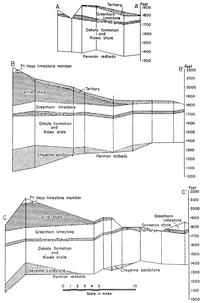
The stratigraphic relationships of the several Cretaceous formations of this area are shown in the cross sections (fig. 2) plotted from test-hole and well-log data.
Figure 2--Generalized cross sections plotted from logs of test holes and oil wells. Locations of cross sections are shown on plate 1.
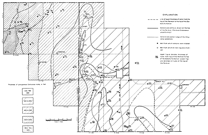
The Cretaceous deposits below the Graneros shale becomes thicker across these counties toward the west. This thickening is shown by the several patterns in figure 3, which also shows by contour lines the configuration of the upper surface of the Permian rocks. The Cheyenne sandstone is thickest in the western part of the area and becomes thinner toward the east, being entirely absent east of central Russell County. The eastern margin of the Cheyenne standstone is shown in figure 3. The areal geology of this and other parts of Kansas is shown on the geologic map of Kansas published by the State Geological Survey of Kansas in 1937.
Permian Rocks
Character--The oldest rocks penetrated in test holes put down during the investigation are Permian redbeds. These rocks have been classified by Norton (1939, pp. 1764-1765) as belonging to the Nippewalla group, and probably represent the Cedar Hills sandstone and Salt Plains formation (personal communication from R. P. Keroher). They consist of alternating beds of red and gray sandstone, red siltstone, and shale. The Permian rocks can be distinguished from the overlying Cretaceous beds in well cuttings by their distinctive brick-red color and the fine texture of the sandstones, The configuration of the upper surface of the Permian rocks is shown by contour lines in figure 3.
Figure 3--Map of parts of Ellis and Russell counties, Kansas, showing changes in thickness of pre-Graneros Cretaceous rocks. The thinning of the pre-Graneros Cretaceous rocks is shown by contour lines and by shaded patterns. The configuration of the surface of the Permian rocks is shown by contours. The eastern margin of the Cheyenne sandstone is also shown. A larger PDF version of this figure is available.
Water supply
No water wells in this area obtain a water supply from the Permian rocks and water samples were not collected from test holes that penetrated these rocks. It is reported, however, that highly mineralized water has been encountered in the Permian redbeds where they have been penetrated by oil wells.
Cretaceous Rocks
Rocks of Cretaceous age crop out or underlie the surface at shallow depths over the entire area under consideration. A general study of the Cretaceous rocks of Russell County was made by Rubey and Bass and published in Bulletin 10 of the State Geological Survey of Kansas (1925). A similar study of these rocks in Ellis County was made by Bass and published in Bulletin 11 of the State Geological Survey of Kansas (1926). Recently a critical study of the pre-Greenhorn Cretaceous rocks has been made in the area immediately east of Russell County by Plummer and Romary (1942). We have used these three reports freely, and much of the following discussion is quoted from them.
Cheyenne Sandstone
Character and thickness--The Cheyenne sandstone does not crop out at the surface anywhere in the area studied but it is an important formation in the subsurface as shown by well logs and cuttings from test holes. This formation was described by F. W. Cragin in 1889 from exposures at Cheyenne rock, near Belvidere in southeastern Kiowa county, Kansas. In the type area the Cheyenne sandstone attains a thickness of 40 feet, and is a cross-bedded loosely cemented sandstone interbedded with shale. The surf ace exposures of this formation nearest to the area discussed herein occur in the type area in Kiowa county. It seems probable that the Cheyenne sandstone occurring under this area has some of the same features that it possesses farther south. Sieve analyses of typical samples of Cheyenne sandstone from Kiowa county are given in table 7.
Well logs and test holes indicate that the Cheyenne sandstone underlying north-central Ellis County attains a maximum thickness in excess of 200 feet. It consists dominantly of moderately well-sorted quartz sand but contains a few beds of shale, and is light gray in color. This formation becomes thinner toward the east and is entirely absent east of central Russell County. The approximate eastern margin of the Cheyenne sandstone is shown on figure 3. This map also shows the thickness of the pre-Graneros Cretaceous rocks, the configuration of the Permian surface, and the well data upon which the map is based.
In 1895, Cragin classified the Cheyenne sandstone as a part of the Elk Creek beds, including the Stokes sandstone member at the top, the Lanphier beds, and the Corral sandstone member at the base. These units have never come into general use, and Twenhofel (1924, pp. 13, 14) has pointed out that they cannot be traced beyond a few square miles in southeastern Kiowa county, where the type localities are located. Minor divisions of the Cheyenne cannot be recognized in the subsurface. In this report the Cheyenne sandstone is used to include the beds designated by Cragin (1889, p. 65) and by Plummer and Romary (1942) as the nonmarine and near-shore deposits, consisting dominantly of quartz sand, unconformably overlying the Permian redbeds and overlain by the marine Kiowa shale.
Water supply--Water from the Cheyenne sandstone is not used in this area for domestic, stock, or public supply, and has been pumped at only a few places as a water supply for drilling oil wells. Water from the Cheyenne sandstone is, for the most part, highly mineralized. This sandstone has been approved by the Kansas State Board of Health as a disposal horizon for oil-field brines. Many of the shallow disposal wells shown on plate 1 are being used for injecting brine into the Cheyenne sandstone.
Kiowa Shale
Character and thickness--The Kiowa shale was named in 1894 by F. W. Cragin (p. 49) and described as the dark- and light-colored fossiliferous shales overlying the Cheyenne sandstone or the Permian "redbeds," and overlain by brown sandstones of middle Cretaceous age, or by Tertiary or Pleistocene deposits. The name was derived from Kiowa county in southwestern Kansas. Although the Kiowa shale does not crop out in Russell or Ellis counties, it underlies the entire area under discussion. It overlies the Cheyenne sandstone and overlaps it to the east, and is overlain by the Dakota formation. Plummer and Romary (1942), who have studied the pre-Greenhorn Cretaceous rocks east and south of Russell County, describe the Kiowa as dark-gray fissile shale containing selenite crystals, bands of "ironstone," and cone-in-cone structures. They further state that the Kiowa also contains sandstone ranging in color from white to brown. These sandstone beds generally are fine-grained and horizontally thin-bedded. Some of them contain glauconite grains, pyrite, and lignite. Molds of marine fossils have been observed in these sandstones, and thin shell beds occur in the Kiowa in the type area. The Kiowa shale closely resembles the Graneros shale in superficial appearance. Plummer and Romary state that east and south of Russell County the maximum thickness of the Kiowa is 100 to 125 feet; available data indicate that under Russell and Ellis counties the thickness of the formation probably does not exceed this amount.
The available data indicate that the Kiowa shale is marine in origin. Many marine invertebrate fossils occur throughout the formation; plant fossils and lignite, common in both the Cheyenne sandstone and Dakota formation, are rare.
In the subsurface it is difficult to distinguish sharply the contact between the Kiowa shale and the overlying Dakota formation because they are seemingly conformable and gradational. Lithologic types prevalent in the lower part of the Dakota formation are also common in the upper part of the Kiowa shale, and the scattered marine fossils are not easily detected in cuttings. The Kiowa is distinguishable, after the transition zone has been passed through, by the absence of abundant siderite, the presence of gypsum and marine fossils, and the decreasing amount and finer texture of the sandstone beds. In the type area, thin limestones are also a distinguishing feature.
Water supply--The Kiowa shale, which consists of shale, silt, and fine-grained sandstone, is a poor water-bearing formation. So far as is known no wells in the areas studied obtain water from this formation.
Dakota Formation
Character and thickness--The term Dakota group was first applied to a stratigraphic unit by Meek and Hayden in 1862 (pages 419, 420), and was defined to include the sandstones, various colored clays, and lignite beds which underlie the "Benton group" in eastern Nebraska. The beds were named from exposures near Dakota City, in Dakota county, Nebraska. They were believed by Meek and Hayden to extend into northeastern Kansas. Since that time the terms "Dakota group," "Dakota sandstone," and "Dakota formation" have been used and misused in Kansas in a multiplicity of ways. In this report Dakota formation is used in the same sense as described by Plummer and Romary (1942) to include those dominantly continental and littoral deposits occurring stratigraphically above the marine Kiowa shale and below the marine Graneros shale in north-central Kansas. The Dakota formation attains a maximum thickness of more than 300 feet.
Many of the stratigraphic names that have been assigned to beds here included in the Dakota formation, such as Mentor beds, Marquette sandstone, and Rocktown channel sandstone, cannot be recognized with certainty from well cuttings and in many places cannot be correlated from one surface exposure to another outside of the type area. Plummer and Romary (1942) describe the Dakota formation as consisting of alternating beds of various colored clay, shale, siltstone, and sandstone (pl. 2A), in which lignite beds are prominent near the top and limonite, hematite, and siderite are abundant throughout. They subdivide the formation into two members, the Janssen clay member (upper) and the Terra Cotta clay member (lower), named from two railroad stations in Ellsworth county, Kansas. They have recognized and correlated these units extensively over the outcrop area, and in many places it is possible to recognize them from well cuttings.
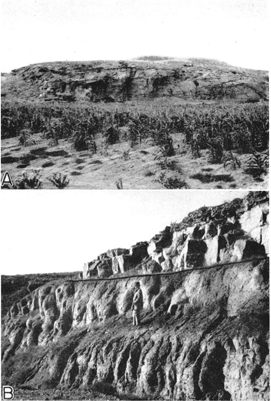
Plate 2--A, Channel sandstone in the upper part of the Dakota formation, north side of Saline valley, north of Bunker Hill. Russell County. B, Codell sandstone member of the Carlile shale and the overlying Fort Hays limestone member of the Niobrara formation north side of Saline valley, south of Codell, Ellis County. (Photographs by Frye.)
In well cuttings the top of the Dakota formation is marked by the appearance of siderite (and/or ankerite), both in angular fragments with inclusions of fine sand and silt and in small globular or micro botryoidal concretions, and by the appearance of kaolin clay minerals. The Graneros shale above is a dark-gray fissile shale containing selenite crystals and pyrite, and the change to light-colored shale or clay, or in some places sandstone, and the appearance of siderite (and/or ankerite) make the contact between the Dakota and the Graneros fairly distinct. The top of the first sandstone cannot safely be taken as the top of the Dakota formation because in some places a prominent sandstone occurs in the Graneros shale and in other places the upper 10 to 40 feet of Dakota consists of shale. Except where displaced by one of the numerous medium- to coarse-grained channel sandstones, the Janssen member of the Dakota formation is composed of light-colored clay, shale, and sandy siltstone containing a recognizable amount of siderite. The Terra Cotta member of the Dakota formation contains a greater abundance of siderite concretions or pellets than the Janssen member, and an abundance of mottled red and gray clay and shale. Siltstone and channel sandstones are also present in the Terra Cotta member.
An excellent exposure of the upper part of the Terra Cotta member and of the Janssen member of the Dakota formation, the Graneros shale, and the lower part of the Greenhorn limestone, occurs along the road cut and the abandoned road cut south of Wilson near the Russell-Ellsworth county line. A measured section is given in table 4.
Table 4--Measured section (No. 9) of Cretaceous rocks exposed along the south side of Smoky Hill valley, south of Wilson, SW sec. 31, T. 14 S., R. 10 W., Ellsworth county. (Measured by John C. Frye and James J. Brazil.)
| Bed No. | Thickness (feet) |
|||
|---|---|---|---|---|
| Greenhorn limestone | ||||
| 18. | Limestone, shale, and sandstone, interbedded. Shale is thin-bedded to fissile, gray to dark brown; sandstone is brown, calcareous, Limestone is irregularly bedded, nodular, cream to gray, and contains calcite veinlets at base. A thin band of light greenish-gray bentonite occurs immediately above the nodular limestone. Three thin bands of bentonite occur near top of interval | +15.0 | ||
| 17. | Sandstone, calcareous. and shale, interbedded; brown to light brown; contains a 4-inch bed of greenish-gray bentonite at top | 2.0 | ||
| Graneros shale | ||||
| 16. | Shale, thin-bedded to fissile, dark gray to black, gypsiferous, containing interlaminations of fine-grained gray sand. Contains ochreous coloring along shale bedding | 24.3 | ||
| 15. | Sandstone, medium-grained, well-sorted, thin-bedded, light brown to buff | 1.4 | ||
| 14. | Shale, carbonaceous, dark gray and brown, containing carbonized plant remains on bedding planes, Fine laminae of fine-grained gray sand distributed through interval; red-brown band of ironstone occurs in the middle | 5.3 | ||
| Dakota formation | ||||
| Janssen clay member | ||||
| 13. | Siltstone, massive, calcareous, light lavender-gray weathering gray-buff, containing fragments of carbonaceous material; Contact between bed 13 and underlying lignitic bed 12 is irregular | 1.4 | ||
| 12. | Shale, fissile, black to dark brown, containing lignitic zones at middle and 1 foot below top. Differential compaction occurs in lignite where irregularities of bed 13 are extended downward | 5.0 | ||
| 11. | Shale, fissile, dark gray to black, containing light-brown partings near top and lignitic zone at middle. Bed is capped by thin, gray, silty limestone which contains "borings" or root molds | 3.7 | ||
| 10. | Shale, carbonaceous, fissile, dark brown to black, containing lignitic zone at middle, and limestone, silty, light gray to light buff, containing borings suggesting mollusks at top | 3.4 | ||
| 9. | Siltstone, sandy, finely laminated, gray on weathered surface, lavender-gray on fresh surface, containing partly filled borings throughout and some charcoal fragments | 1.2 | ||
| 8. | Shale, thin-bedded, dark gray to black, gypsiferous, Lower part thinly interbedded with light-brown to yellow-brown sandy siltstone | 14.8 | ||
| 7. | Shale, gray, containing irregular interlaminations of gray silty shale and fine gray sand. Thin band of red-brown iron-stained siltstone at top | 5.3 | ||
| 6. | Sandstone, iron-cemented, brown to light brown, containing thin streak of red-brown ironstone at middle | 1.8 | ||
| 5. | Shale, fissile, dark gray to black; mottled brown and gray at top | 7.6 | ||
| 4. | Sandstone, massive, fine-grained, well-sorted, gray, tan and yellow-orange, containing carbonaceous material along bedding planes. Lower 6 feet include sandstone concretions containing inclusions of shale and claystone. Thin zones of finely interlaminated gray silty shale and fine-grained gray sand occur approximately 8 feet from the top and from the base | 29.4 | ||
| Terra Cotta clay member | ||||
| 3. | Shale, irregularly bedded, gray at top and dark gray at base. Massive irregular bed of gray, yellow-brown, and reddish-gray sandy silt at middle containing bands of sandy siltstone nodules immediately above and below and numerous small concretions of hematite which give the weathered surface a sugary texture | 12.1 | ||
| 2. | Sandstone, fine-grained, massive, well-sorted, angular to subangular, light gray-buff | 3.6 | ||
| 1. | Shale, silty, massive, red to brick-red, gray and yellow-brown mottled; shot-like concretions of iron numerous on weathered surface | 37.0 | ||
| Covered interval | 12.0 | |||
| Total thickness | 186.3 | |||
The evidence indicates that the sediments comprising the Dakota formation were deposited in a continental and littoral environment, probably including extensive coastal lagoons and tidal marshes. This environment is attested by. the abundant plant fossils, lignite beds, and, in a few places, the remains of land vertebrates, The presence of abundant siderite (or ankerite) seems to indicate reducing waters, such as might be found in a lagoon or marsh environment. The fact that. siderite and related minerals constitute the prevalent occurrence of iron in these deposits becomes evident only when well cuttings are examined. In many exposures the siderite seemingly has been weathered near the surface to limonite or hematite. The foregoing indicates that the arm of the sea which covered this part of Kansas during the time the Kiowa shale was being deposited withdrew temporarily during Dakota time. The re-advance of this sea is attested by the overlying marine Graneros shale and younger Cretaceous rocks.
Water supply--As stated above, the Dakota formation consists dominantly of clay, shale, and siltstone containing beds of fine-grained sandstone and an interlacing network of channel sandstones (pl. 2A). Water can be obtained from some of the widespread and fairly persistent fine-grained sandstones, but the most abundant supplies are obtained from the coarser textured channel sandstones. Because of the discontinuous nature of these channel sandstones, the quantity of water obtainable at any locality cannot be determined with certainty without test drilling.
In Russell County many domestic and stock wells obtain water from one or more of the sandstones in the Dakota formation. Records of several of these wells are given in table 13. The quality of the water obtainable from these various sandstone lenses is quite variable; some wells yield water of usable quality, whereas water from other wells is too highly mineralized to be suitable for most uses. Analyses of water from sandstones in the Dakota formation are given in figure 9 and tables 10 and 11.
Graneros Shale
Character and thickness--The Graneros shale consists of 25 to 40 feet of dark-gray to blue-gray shale overlying the Dakota formation and overlain by the Greenhorn limestone. The Graneros shale is characterized by selenite, pyrite, and thin streaks of iron sulphate along bedding planes and joints, and locally contains thin beds of sandstone. The Graneros shale in Russell County has been described by Rubey and Bass (1925, pp. 51-54) and in Ellis County by Bass (1926, pp. 35, 36). Locally, thin beds of limestone occur near the top of the formation and beds of iron-cemented siltstone occur near the base. From well cuttings the formation is known to consist wholly of sand in some places. It can be distinguished from the overlying Greenhorn limestone because it is dominantly noncalcareous and sandy, and it can be distinguished from the Dakota formation below on the basis of its color, the absence of abundant siderite and kaolin, and the presence of abundant selenite and pyrite.
Water supply--The Graneros shale consists dominantly of shale, hence it generally yields little or no water to wells. In some localities where the formation is sandy it yields meager supplies of water, but even in such places the water is of poor quality. No wells were observed in the area that obtain water from this formation.
Greenhorn Limestone
Character and thickness--The Greenhorn limestone underlies most of the upland areas in central Russell County and dips below the bottoms of the deepest valleys in eastern Ellis County. The Greenhorn limestone has been studied in detail in Ellis County by Bass (1926, pp. 31-35) and in Russell County by Rubey and Bass (1925, pp. 45-51), who describe this formation in Russell County as follows:
This formation crops out on both sides of the valleys of the tributaries of the three large streams that run eastward across Russell County-Smoky Hill and Saline rivers and Wolf creek. Hard chalk in beds less than a foot thick alternate with chalky shale in the upper three-fourths of the formation. The proportion of chalk to marl is highest about one-fourth of the way down from the top. The lower fourth of the formation contains, in addition to the chalk and chalky shale, thin beds of hard crystalline limestone. From several measurements it seems that the thickness of the Greenhorn limestone decreases from 105 to 110 feet in the northern part of Russell County, south-southeastward to 85 or 90 feet in the southern part.
The great abundance of the fossil Inoceramus labiatus, the stratigraphic position, and the calcareous composition of the formation permit a close correlation of the formation with the Greenhorn limestone of parts of Colorado, Wyoming, and elsewhere. The name Greenhorn was given by Gilbert, in 1896 (p. 564), to corresponding beds in southern Colorado, which are typically exposed at Greenhorn station and on Greenhorn creek, south of Pueblo, Colorado. The formation in Russell County, Kansas, is divided into four members, here listed in descending order: (1) An upper unnamed member [Pfeifer shale] consisting of beds of chalky shale and fossiliferous chalk; (2) the Jetmore chalk member, which consists of regularly alternating beds of chalk and chalky shale; (3) an unnamed member of chalky shale [Hartland shale] containing few beds of chalk; and (4) the Lincoln limestone member, consisting of thin beds of crystalline limestone in a series of beds of chalk and chalky shale.
Well cuttings from this formation consist of fragments of dark-gray calcareous shale and limestone. The shale fragments are typically speckled with light-gray flakes of calcium carbonate. These characteristics make the cuttings easily distinguishable from the Graneros shale below, but less easily distinguishable from the overlying Fairport chalky shale member of the Carlile shale. It is difficult to recognize subdivisions of the Greenhorn from well cuttings owing to the nearly uniform nature of the rocks. The hard limestone beds are, for the most part, too thin to distinguish and are fairly evenly distributed throughout the formation.
Water supply--At some localities in Russell County water for domestic and stock use is obtained from the near-surface weathered part of the Greenhorn limestone. Such wells are nearly all dug to shallow depths and are of relatively large diameter to afford maximum collecting and storage capacity. Water collects along bedding planes, joints, and fractures in the limestone, but in most places the quantity available from this formation is meager. Water is obtained only in the near-surface weathered part of the Greenhorn. The mantle rock that develops on the Greenhorn outcrops is more permeable than the mantle rock over the dominantly shale formations, because the. thin limestone beds weather to angular pieces and so maintain somewhat of an open textured deposit through which ground water can circulate. Chemical analyses of water from the Greenhorn are given in figure 8 and table 10.
Carlile Shale
Character and thickness--The Carlile shale underlies all of the uplands of Ellis County, and remnants of it cap the uplands of western Russell County. It has been described in Russell County by Rubey and Bass (1925, pp. 32-45), and in Ellis County by Bass (1926, pp. 26-31). Bass (p. 26) describes the Carlile shale in Ellis County as follows:
Chalky and clay shale, about 300 feet thick, that contains thin beds of chalk near its base, numerous zones of septarian lime concretions in its upper half, and a unit of fine-grained sandstone at its top, constitutes the Carlile shale. The upper two-thirds is made up predominantly of gray-black fissile clay shale, and the lower third of chalky shale and thin beds of chalky limestone. In Ellis County it is separable into the Blue Hill shale member above and the Fairport chalky shale member below.
The Blue Hill shale member ranges in thickness from 175 to 215 feet. It is nonresistant on exposure and forms rounded slopes. The upper part of this member is typically sandy in these counties and was named the Codell sandstone bed (pl. 2B) by Bass (1926, p. 28). In 1933, Dane and Pierce (1933) elevated Codell sandstone to the rank of a member at the top of the Carlile shale and restricted the Blue Hill shale member to the underlying part of the Blue Hill shale of previous reports. The Codell is referred to in this report as a member rather than a bed or zone of the Blue Hill shale because it is easily recognizable on the surface and in well cuttings by its distinctive lithology and color, and because it is widespread in western Kansas. In Kansas it ranges in thickness from a few inches to more than 20 feet. The Codell is well exposed in the bluffs along the north side of Saline valley west of the Russell-Ellis County line (see pl. 2). In this area the Codell sandstone member is about 20 feet thick, is very fine-grained, and is loosely cemented with calcium carbonate. In the type area this member is dominantly silt at the base and grades downward into silty shale.
In well cuttings the Fort Hays limestone member of the Niobrara formation is readily distinguishable from the underlying Codell sandstone member and the dark-gray, noncalcareous shale of the Carlile. Where the Codell member is present it can be recognized as a silty, fine-grained sandstone, light gray to white in color. The Fairport chalky shale member can be distinguished from the Blue Hill shale member by its chalky character, but it is more difficult to distinguish the Fairport-Greenhorn contact.
Water supply--Although a few shallow dug wells obtain meager supplies of water from the weathered near-surface part of the shale and mantle rock, it is, on the whole, not a good water-bearing formation. The Codell sandstone member is the only part of this formation that generally yields adequate supplies of water for domestic and stock use, and it is probable that none of the wells in the Codell will yield as much as 10 gallons a minute because of the fine texture of the sandstone. Many wells have been drilled and dug into the Codell in north-central Ellis County; records of some of these wells are given in table 14. The quality of the water obtained from this member is satisfactory for most uses. Analyses of water from the Codell sandstone member are given in figure 8 and table 11.
Niobrara Formation
Character and thickness--The Niobrara formation crops out in the northwestern corner of Russell County and underlies much of the upland area of central and northern Ellis County. At no place in the area under consideration does the entire thickness of the formation occur, the upper part having been removed by erosion. The maximum thickness of the Niobrara formation exposed in this area is about 150 feet. Bass (1926, pp. 19-26) has described the occurrence and lithology of this formation in Ellis County, where it is divided into two members-the Smoky Hill chalk member (upper) and the Fort Hays limestone member (lower). The Smoky Hill member consists of marl beds alternating with beds of chalk and clay. The Fort Hays member (pl. 2B) is the better exposed in this area and has been described by Bass (1926, p. 24) as follows:
Massively bedded cream-colored chalk or very chalky limestone, aggregating 55 feet in thickness, . . . The individual beds of chalky limestone range in thickness from 6 inches to 6 feet and average about 2 1/2 to 3 feet; these beds are separated by thin layers, 1 to 4 inches thick, of light gray to dark gray chalky clay shale. The bedding is thinner toward the top of the member, and the upper beds commonly weather almost pure white. In contrast with the chalk of the overlying Smoky Hill member the rock of the Fort Hays member appears slightly coarser in texture and somewhat harder.
Water supply--A quantity of water sufficient for domestic and stock use generally cannot be obtained from the Niobrara formation, None of the wells visited in Russell and Ellis counties obtained water from this formation. It is possible, however, that in certain localities some water has accumulated in the weathered near-surface part of this formation and shallow dug wells in such areas may yield sufficient water for some purposes.
Tertiary Rocks
Ogallala (?) Formation
Character and thickness--Deposits of Tertiary age are spread over the upland areas of much of northern Ellis County, and discontinuous areas of Tertiary deposits occur on the divides in western and central Russell County, Bass (1926, p. 16) correlated these deposits in Ellis County with the Ogallala formation of western Kansas and Nebraska and stated that they attain a maximum thickness of 75 feet. In Russell County east of the Fort Hays escarpment these upland deposits attain a maximum thickness of about 40 feet (Frye, Leonard and Hibbard, 1943, p. 34). They consist of gravel, sand, silt, and clay, and locally are cemented with calcium carbonate and contain nodules of calcium carbonate. These deposits range within wide limits in texture and lithology. In some places the sand and gravel consist dominantly of pebbles and grains of limestone, but elsewhere well-sorted quartz sand occurs, and sand and gravel containing abundant grains of feldspar and granite are exposed north of Gorham and at several places in Ellis County.
The age of these deposits east of the Fort Hays escarpment is in doubt. They are not continuous with the deposits overlying the Fort Hays member which were correlated by Bass with the Ogallala, but occur at a lower elevation. It is unlikely that two adjacent stream-laid deposits at different altitudes can be of the same age, even though erosion may have given some surface expression to the Fort Hays escarpment in pre-Ogallala time. It is probable that the upland deposits of Russell County and eastern Ellis County are younger than the Ogallala of Ellis County, and they are certainly older than the oldest Pleistocene terrace deposits along Smoky Hill and Saline river valleys. They are probably uppermost Pliocene or lowermost Pleistocene in age. No fossils have as yet been taken from these deposits.
Water supply--In those areas where an appreciable thickness of Tertiary sand or gravel occurs, supplies of ground water generally have been found to be adequate for domestic and. stock needs. Records of wells dug or drilled into these deposits are given in table 13. Many wells in the area north of Gorham in west-central Russell County obtain water from Tertiary (1) sand and gravel. A large well was drilled during 1941 in this area to obtain a water supply for the city of Gorham, but data on this well have not been made available. Water obtained from the Tertiary deposits is reported to be generally of good quality; typical analyses are given in figure 8 and table 10.
Pleistocene Deposits
Terrace deposits of presumed Pleistocene age were noted a number of years ago along the valleys of Smoky Hill and Saline rivers in Russell (Rubey and Bass, 1925, pp. 19-25) and Ellis (Bass, 1926, pp. 16-18} counties. Earlier, Logan (1897, pp. 218, 219) had described gravel beds in this area which he believed to be younger than the "Tertiary grit" (Ogallala formation) and referred to them as the "Salt Creek gravel beds." Recently a more detailed study has been made of these terrace deposits (Frye, Leonard, and Hibbard; 1943), particularly along Smoky Hill valley.
Character and thickness--The Pleistocene terrace deposits consist of gravel, sand, silt, and clay; they underlie the surface of welldefined terraces along the Smoky Hill and Saline valleys and several of their major tributaries, particularly Big creek. The height above the present flood plain of the highest Pleistocene terrace gradually increases eastward across the area, reaching a maximum of nearly 150 feet in eastern Russell County. In this same part of the area the valley at the high terrace level attains a maximum width of 6 miles.
The high terrace where well preserved is characterized by a nearly flat upper surface underlain by 20 to 75 feet of gravel, sand, and silt. The boundary between the high terrace surface and outer slopes of the valley is not sharp except where it has been accentuated by recent erosion, but is marked by a gently sloping surface that rises to the upland level. The stream ward margins of the terraces are marked in most places by distinct scarps.
It has been pointed out that these terrace beds probably were deposited during the early Pleistocene by streams flowing from the Rocky Mountain region (Frye, Leonard, and Hibbard, 1943). In some places the gravels consist largely of limestone pebbles derived from the near-by Cretaceous rocks, but in many places the sand and gravel consist dominantly of grains and pebbles of quartz, feldspar, granite, and other igneous rocks. Many Pleistocene vertebrate and invertebrate fossils occur in the silt and clay beds of the terrace deposits. The presence of Pleistocene fossils together with the fact that these terraces can be traced down Smoky Hill valley nearly to the type locality of the McPherson formation (restricted) (Lohman and Frye, 1940; Frye and Hibbard, 1941) indicates that the deposits are equivalent, at least in part, to the McPherson formation.
Water supply--Many wells obtain water for domestic and stork use from the sand and gravel beds of the Pleistocene terrace deposits, particularly along the valleys of Smoky Hill and Saline rivers and Big creek. Records of typical wells in the Pleistocene deposits are given in table 13. In areas where the terraces have been extensively dissected these deposits contain only a small amount of water, or are dry, but under the broad undissected terrace areas large supplies of ground water generally are available. No large Kells have been constructed in these deposits but it is possible that wells yielding as much as several hundred gallons a minute could be developed in a few places where the terrace gravels attain maximum thickness. Except in areas where this shallow ground water bas been polluted by brine from disposal ponds, improperly cased wells, or seepage from polluted Cretaceous sandstones, the quality of water obtained from the Pleistocene deposits is satisfactory for most uses. Analyses of typical waters from the Pleistocene deposits are given in tables 10 and 11 and figure 8.
Recent Alluvium
Character and thickness--Deposits of gravel, sand, silt, and clay of Recent age occur along the valleys and underlie the flood plains of the principal streams of this area, and occur also along the bottoms of some of the small stream valleys. The character and thickness of the alluvium range within wide limits, but in most places the alluvium contains some water-bearing sand or gravel. The alluvium exceeds 40 feet in thickness in only a very few places. The band of alluvium along the principal stream valleys attains a maximum width of about a half mile, but in most places it is less than a quarter mile in width.
Water supply--Recent alluvium underlies only a small part of the total area; hence it does not constitute as important a source of ground-water supplies as does similar material in other parts of the state. It yields abundant supplies to wells along the major valleys, however, and yields meager supplies along the small stream valleys. Wells yielding as much as 500 gallons a minute might be obtained at the most favorable places in the alluvium. The water obtainable from the alluvium, although having considerable hardness, is satisfactory for most uses except in areas where it is contaminated by oil-field brine.
Prev Page--Oil-field History || Next Page--Geologic History
Kansas Geological Survey, Geology
Placed on web Jan. 26, 2017; originally published December 1944.
Comments to webadmin@kgs.ku.edu
The URL for this page is http://www.kgs.ku.edu/Publications/Bulletins/50/04_form.html