![]()
Prev Page--Introduction || Next Page--Climate
Topography
General Features
Southwestern Kansas lies in the central High Plains region, and forms part of the broad treeless plain that, with some minor irregularities, slopes gently eastward from the Rocky Mountain front toward the Mississippi valley. The prevailing slope of this Plains surface is so slight as to seem almost perfectly fiat, although actually the slopes average about 10 feet to the mile. Crossing the Plains in this area are two major streams: the Arkansas in the north, and the Cimarron in the south. These streams derive the greater part of their water from areas west of Kansas, and here receive the surface drainage only of relatively narrow belts bordering their own valleys and their widely separated tributary valleys. Large portions of the interstream areas have no outside surface drainage whatever. The total relief of the area considered in this report is slightly less than 2,100 feet. Altitudes range from 1,725 feet above sea level in the southeastern corner to nearly 3,800 feet in the northwestern corner. Local relief is slight on the Plains surface, but is as much as 300 feet along the larger stream valleys.
The true Plains surface, although extensive, is by no means continuous over the entire area, for well below the general level lie stream valleys ranging from less than 1 mile to more than 10 miles in width. For the most part, these valleys trend parallel to the regional slope, but locally there are notable exceptions, as in Meade County, where the valley of Crooked creek lies transverse to the slope of the Plains for about 30 miles. Cutting across the upland in many directions, these valleys divide it into separate sections, and in places leave only narrow, dissected remnants. At the southeast, dissection is so extensive as to mark the border of the Plains. There the upland surface terminates at an irregular escarpment, dropping 500 feet over the Red Hills to the greatly broadened valley of Cimarron river.
A more detailed discussion of topography is given in the following pages. This discussion is confined to description, whereas interpretations and explanations are reserved for a later section on physiography. Plates 1 and 2 show the regional topography pictorially and graphically.
Plate 1--Relief map of southwestern Kansas. Photograph of a part of the relief model of the state prepared under direction of R. C. Moore. Photograph by Bingham.
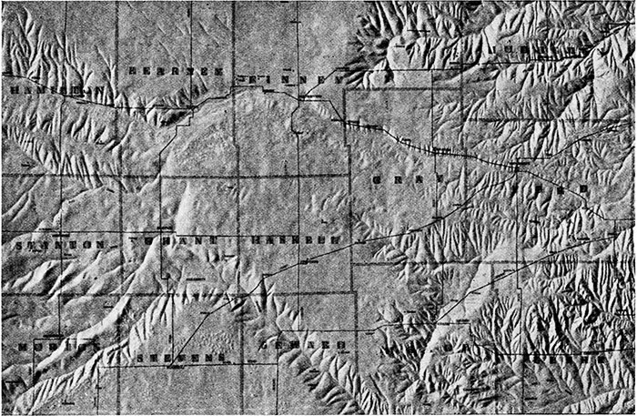
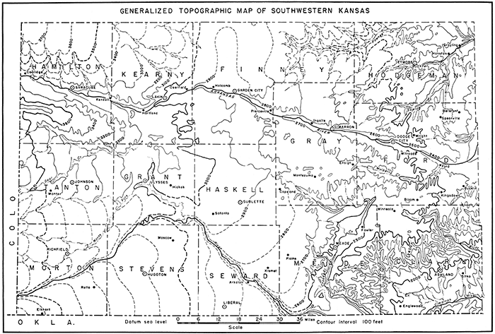
Plate 2--Generalized contour map of southwestern Kansas. Compiled from topographic sheets of the U. S. Geological Survey, level lines of the U. S. Coast and Geodetic Survey, State Highway surveys, and aneroid reconnaissance by the writer. [A larger Acrobat PDF version of this figure is available.]
The Plains
The greater part of southwestern Kansas is characterized by the plains type of topography. Entering the area at the west at altitudes of 3600 to more than 3700 feet, the plains slope down to about 2400 feet at the eastern edge of the area. Although the regional declivity is to the east, locally there are important departures from this direction, as well as variations in the rate of slope, which generally is steeper in the western part than in the eastern part of the area. These may best be considered in connection with the separate sections into which the plains are divided by stream valleys.
North of Arkansas river the plains are divided into an eastern and a western area by a broad, shallow depression extending north from Garden City. The western or Kearny area has a general slope south of east, toward the depression, but also slopes somewhat toward the Arkansas along its southern margin. The average slope from west to east is about 15 feet per mile. East of the Garden City depression, in the Kalvesta area, the slope is almost uniformly eastward, and is gentler, averaging about 10 feet per mile. The eastern and northern portions of this area are much dissected by Pawnee river, Buckner creek, and Saw log creek, and their tributaries, leaving narrow and irregularly branching remnants of upland in the interstream areas.
Between the Arkansas and Cimarron valleys there are three divisions of the plains: one of major extent in the central and eastern part of the area, and two of lesser extent in the west. (1) The smallest is the Syracuse upland in southern Hamilton County, constituting a long, narrow upland between the Arkansas and the northern tributary of Bear creek. (2) South of this, between Bear creek and the Cimarron, lies the broader Stanton area, bounded on the east by the southeastern stretch of North Fork of the Cimarron, and a northsouth tributary valley. From west to east, it is trenched by North Fork and its nearly parallel tributaries. To the north it grades almost imperceptibly into the lowland of the Bear creek drainage basin. The general slope here is slightly north of east, and averages about 15 feet per mile. (3) Extending from central Grant County to the eastern edge of the area is the Haskell area, the largest area of typical plains country. Its slope is southeast to east-southeast, and the grade is as low as 7 feet per mile. Its eastern extension, the Minneola area, is bounded by the Red Hills escarpment, is almost completely cut off by the broad, transverse valley of Crooked creek, and is deeply indented also by Mulberry creek, Bluff creek, and the headwaters of Rattlesnake creek.
South of Cimarron river lies the other division of the plains, the Cimarron Bend area. At the west, this area is essentially continuous with the area north of the river, but at the east there is a distinct difference, for the slope here, in contrast to that northeast of the river, is easterly. The topography of this area is more irregular than that of the others, having many uneven low hills and hummocks and intervening depressions, owing partly to the presence of sand dunes, some ancient and some modern. There is no outside drainage, except in a narrow belt bordering the river, where short gulches cut into the upland.
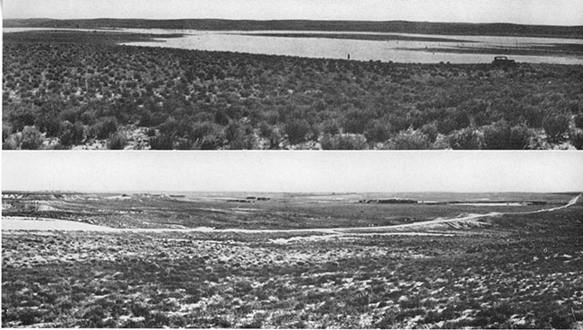
Everywhere on the plains surface, broad shallow undrained depressions are a common feature. These range in shape from sub-circular to elongate, and in size from less than a hundred feet to a few miles in their longest dimension. For the most part, their sides slope very gently toward the center, and in some places short tributary valleys drain into them. After heavy rainfall they commonly hold temporary ponds or lakes.
Valleys of the Arkansas Drainage
Arkansas river rises in the mountains of central Colorado, and, leaving the mountains through the Royal Gorge, flows in a nearly straight line across southeastern Colorado into Kansas. At a point in southern Kearny County it swings toward the northeast, continues in this direction for nearly 20 miles, then turns south of east once more, and continues thence in a nearly straight line again to a point in eastern Ford County, where it curves northeast toward Great Bend. In the southwestern Kansas region, the river has an average gradient of about 6 feet per mile. Its open channel narrows from nearly 600 feet in width at the west (pl. 3A) to 200 or 300 feet at the east (pl. 3B). The channel is shallow and sandy, and contains many bars and islands. Much of the time there is little or no flow, the water being diverted for irrigation. Bordering and in fact crowding the channel at many places are heavy stands of cottonwood and tamarisk.
Plate 3--The channel of Arkansas river: A, At Kendall, July, 1938. B, At Cimarron, more than 70 miles to the east, August, 1937.
The valley bottom or inner valley of the Arkansas ranges in width from less than 1 mile to about 4 miles. It is narrowest near Hartland, in western Kearny County, and widest in eastern Kearny County, in the Lakin-Deerfield district. Bordering the valley plain on the north is an almost continuous line of bluffs as much as 100 feet high. These bluffs are extensively notched by short tributary valleys. South of the river, slopes are less abrupt, and the topography is dominated by a persistent belt of sand hills. This belt ranges in width from less than 1 mile to about 18 miles, being broadest in southwestern Finney County and adjoining districts, where the river bends to the north.
The outer valley of the Arkansas, comprising all land sloping toward the river and lying below the level of the upland plains, is 5 to 20 miles wide. Its southern boundary is roughly coextensive with that of the sand-hills belt, but its northern boundary lies much closer to the river, the position being determined by the rim of the bordering bluffs. The depth of this outer valley ranges from about 300 feet at the west to about 100 feet at the east.
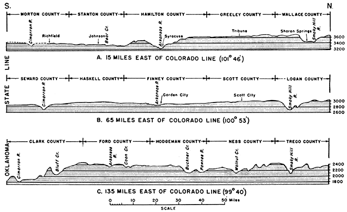
An unusual feature of the Arkansas is the elevation of its channel in comparison with those of the Cimarron to the south and the Smoky Hill to the north. Although it enters the state at a much lower altitude than either of those streams, the Arkansas descends less rapidly, and, eastward, becomes higher and higher above the channels of its sister streams. At the eastern edge of the area it is more than 500 feet above the Cimarron and more than 200 feet above the Smoky Hill (fig. 2).
Figure 2--Topographic profiles of southwestern Kansas. These profiles are based on data from topographic maps of the U. S. Geological Survey and level lines of the U. S. Coast and Geodetic Survey, supplemented by aneroid reconnaissance.
Topographically continuous with the Arkansas valley, although having no surface drainage into it, is the broad, irregular, Scott-Finney depression, which extends northward from Garden City to Scott City. This depression is asymmetrical, being bounded on the east in many places by a definite escarpment that is as much as 50 feet high, but at the west sloping upward gradually and merging with the plains surface. It has no thoroughgoing drainage, and its floor is very uneven, having numerous depressions of various sizes and shapes, and many marshy areas. East-southeastward-flowing streams from Kearny County are "lost" as they enter the depression.
Arkansas river has comparatively few tributaries of appreciable size in this area and the distribution of these few is far from uniform. On the north side, the only tributaries of any consequence are found in Hamilton County. These streams are 10 miles or more in length, and have valleys more than 50 feet deep. The larger tributaries of the Arkansas in the northeastern part of the area join the main river at some distance beyond the area. The principal drainage lines are Pawnee river, Buckner creek, Sawlog creek, and Coon creek. These streams flow in a general easterly direction, and in part are parallel to the Arkansas. It is surprising to find that, except in headward stretches, the tributaries have gradients that are flatter than the gradient of the main river. The tributaries head within a very few miles of the Arkansas valley and for some distance flow away from the main stream, so that the drainage divide between the two is crowded against the latter. The tributary streams, for the most part, have some permanent flow, even though slight. Their channels are narrow grooves that flare upward into broader grooves, which cut downward about 20 feet below the general level of the valley plain. The total width of the inner and outer channels generally does not exceed 50 yards.
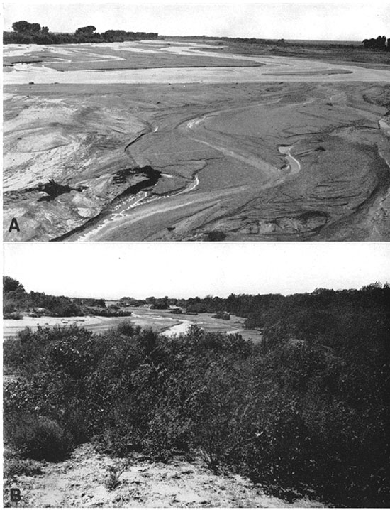
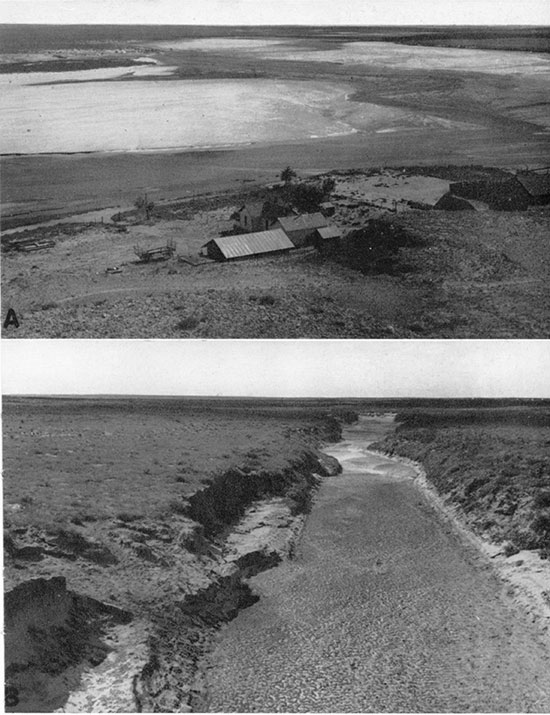
South of the Arkansas in this area there are only two significant tributaries, Bear creek at the west and Mulberry creek at the east, and the very headward portion of a third, Rattlesnake creek, which flows into the main stream far to the east. Bear creek heads in southwestern Colorado nearly 50 miles west of the Kansas line. Together with its tributaries, it drains a broad lowland in southern Hamilton and northern Stanton counties, and, swinging to the north across southern Kearny County, approaches the Arkansas, only to end in a depressed basin amid the sand hills south of Hartland. In time of flood this basin is filled, and the water spreads out around the sand hills forming irregular ponds and lakes (pl. 4A), which persist for many days, until depleted by evaporation and infiltration. Although coming within about 4 miles of the Arkansas, the flood waters of Bear creek rarely if ever reach that stream. (Haworth, 1897a, pp. 23-24; Darton, 1920, p. 3.) From west to east the valley of Bear creek becomes shallower, the depth decreasing from about 60 feet to less than 20 feet. By means of a trench 20 feet deep and a few miles long, at a point near the Grant-Kearny county line, the waters of Bear creek could be diverted to the Cimarron drainage.
Plate 4--A, Ponds in the sand hills near the mouth of Bear creek, after heavy rains in June, 1936. B, Panoramic view of the Cimarron valley in eastern Seward County, near Arkalon, looking southwest.
Mulberry creek heads in east-central Gray County, flows parallel to the Arkansas for about 20 miles through Ford County, and then swings northeast to join the main stream at the town of Ford. Its channel is narrow, and is incised below the valley flat to a depth ranging from less than 10 feet at the west to about 25 feet at the east. Although the valley bottom is comparatively narrow--generally less than a quarter of a mile in width--the valley as a whole, including the slopes of small, closely spaced tributaries, is 1 to 4 miles wide, and forms a deep embayment in the upland. Although shallow near its source, the valley becomes rapidly deeper, and through much of its course has a depth of about 100 feet. The bordering slopes are gentle at the west, but fairly steep farther east.
Valleys of the Cimarron Drainage
Cimarron river heads in northeastern New Mexico, in the lava-capped mesas east of Raton. It flows east into the panhandle of Oklahoma, turns northeast across the southeastern corner of Colorado, and continues northeastward in Kansas from southwestern Morton County to southern Grant County, where it curves east for a short distance, then swings abruptly southeastward across Seward County and southwestern Meade County, almost at right angles to its previous course. In southern Meade County it grazes the Oklahoma line, curves gently north for a short distance, and leaves the state in the south-central part of the county. In Oklahoma it continues eastward near and almost parallel to the Kansas line, and reenters Kansas in south-central Clark County, flowing north of east into Comanche County.
From the Colorado line to southwestern Meade County, the Cimarron has an average gradient of about 10 feet per mile. In southeastern Clark County, however, it flattens to less than 8 feet per mile. The channel is shallow, and of variable width. It narrows steadily from about 800 feet in southwestern Morton County to 65 feet in southwestern Haskell County (pl. 5) and then gradually broadens downstream to several hundred feet. The channel is sandy, and has no through going permanent flow, although to the east and to the west of the narrowest part there is some water at nearly all times. The valley bottom in most places is considerably less than a mile in width, but broadens somewhat in southwestern Meade County and southern Clark County. The entire valley, from rim to rim, is only a few miles wide along the greater part of the stream's course. In southern Clark County, however, it broadens somewhat abruptly into a wide basin. From Morton County to southwestern Haskell County the valley averages about 100 feet in depth, but to the southeast it deepens to more than 200 feet in southeastern Seward County, where also the valley slopes are steepest and most abrupt (pl. 4B). In Clark County the valley again becomes somewhat shallower.
Plate 5--Channel of Cimarron river: A, At Point Rock, in western Morton County, August, 1937. B, In southwestern Haskell County, at the crossing of State Highway 45, more than 50 miles downstream, August, 1937.
Until it reaches Meade County, the Cimarron has only one important tributary in this area, North Fork of the Cimarron. This stream heads in southeastern Colorado about 30 miles west of the Kansas line, and enters Morton County about 12 miles north of the main Cimarron. It flows northeast nearly parallel to the Cimarron as far as central Grant County, then turns abruptly to the southeast and joins the main stream in the southeastern corner of the county. It has two widely separated tributaries in northern Morton County and southern Stanton County. Its valley is shallower and slightly narrower than that of the Cimarron.
The most important--and most unusual--of the Cimarron's tributaries in this area is Crooked creek. This stream heads at the eastern edge of Haskell County, flows southeast through Gray County across the Meade County line, swings north of east into southwestern Ford County, and there doubles back on itself to flow south-southwest through Meade County. In south-central Meade County, it turns again to the southeast, leaves the state in the southeastern corner of the county, and joins the Cimarron in Oklahoma. In Meade County the valley of Crooked creek is strongly asymmetrical; north of the town of Meade the western side slopes more steeply, but south of Meade the eastern side is the steeper. North of Meade, also, the valley is a broad, shallow basin, and the stream's gradient is comparatively flat. South of Meade, the valley becomes narrower and deeper, and the stream's gradient is steeper. In both sections numerous short tributary valleys enter from the west. The actual channel of Crooked creek is inconspicuous and easily may be crossed on foot during dry periods. In times of heavy rainfall, however, the sluggish stream quickly overflows its banks and floods wide areas of bottom land, damaging crops and washing out roads and bridges.
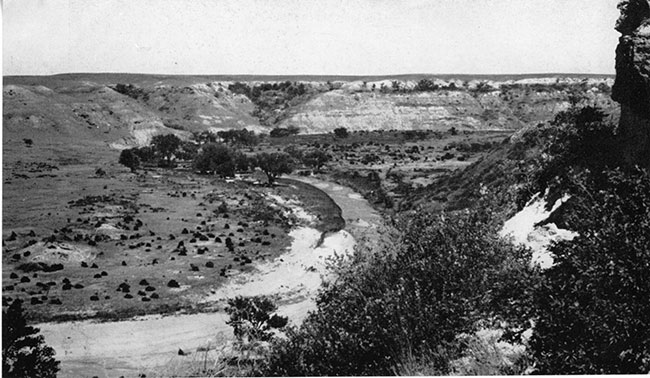
In northern Clark County, another important tributary is Bluff creek. This stream rises just across the Ford County line, curves east south of the county line, flows east about 12 miles, and then bends abruptly south. After flowing south for several miles, it veers to the southeast and crosses into Comanche County, then turns south again and enters the Cimarron a few miles east of the Clark County line. Along its upper stretches, the valley of Bluff creek is comparatively narrow, and has a maximum depth of about 200 feet. It is enclosed between steep, varicolored bluffs, which give the stream its name (pl. 6). Toward its mouth, the valley becomes shallow and broad.
Plate 6--Bluff creek valley, just north of Clark County State Lake. The bluffs on the far side expose Kiowa shale up to the line of trees, which marks the base of the Ogallala formation.
Between Bluff creek and Crooked creek there are many small tributaries, but no very large ones. These streams are mostly mere sandy arroyos. They are comparatively close-spaced, and ramify headward into innumerable small branches.
Red Hills and Ashland Basin
The Red Hills (Adams, 1903) constitute a jagged, irregular escarpment leading down from the upland plain to the Ashland basin. They begin in eastern Meade County, cross northern Clark County, and extend for a long distance to the east. Fenneman (1931, p. 28) notes that "this escarpment is not a single abrupt descent, but a deeply eroded belt 10 to 20 miles wide." Cutting across Permian redbeds and the gray to brown Cretaceous rocks, and displaying innumerable mesas, buttes, and small canyons, this feature is one of the most colorful and picturesque in Kansas. Its total relief is about 500 feet, and local relief is as much as 300 feet.
The Ashland basin is a broad lowland lying between the Cimarron bluffs to the south and the Red Hills to the north. It is trenched by the valleys of many small streams, and is by no means a flat surface, although its relief is low in comparison with the rugged hills to the north. Bordering the Cimarron and certain of its tributaries there are belts of sand dunes, which in places cover areas of many square miles.
Prev Page--Introduction || Next Page--Climate
Kansas Geological Survey, Geology
Placed on web Feb. 8, 2017; originally published September 15, 1940.
Comments to webadmin@kgs.ku.edu
The URL for this page is http://www.kgs.ku.edu/Publications/Bulletins/34/03_topo.html