Kansas Geological Survey, Bulletin 223, part 1, originally published in 1981
Next page--Appendix A
Originally published in 1981 as Kansas Geological Survey Bulletin 223, part 1. This is, in general, the original text as published. The information has not been updated.
During the last few years, as a result of the increasingly uncertain supplies of raw mineral materials, including copper, from abroad, interest in exploring for and developing these resources in the United States has revived.
Copper carbonates have long been known to occur in surface outcrops of Permian age in Sumner, Sedgwick, and Harper counties in south-central Kansas, and copper has been mined from rocks of similar age in Oklahoma. The Permian rocks, in which the copper occurs, overlie the important Hutchinson salt beds, which have been studied in some detail because of potential pollution of fresh water supplies and the collapses of the overlying rock units due to the dissolution of the salt. However, not much is known about the sediments in which the copper occurs. This study was initiated with the idea of evaluating the occurrences of copper in the subsurface.
A number of holes were drilled and core was recovered with the aim of intersecting the copper-containing beds. The first part of the study focuses on the stratigraphy and the nature of the host rocks. We found many mineralized horizons, rather than just a couple as was previously believed. However, no economic concentrations of copper were encountered.
Examination of core extracted from 16 drill holes in Sedgwick, Sumner, and Harper counties, together with a review of the literature, indicates that copper mineralization of the stratiform type occurs all through the non-oxidized parts of the upper part of the Wellington Formation and the Ninnescah Shale. The mineralized units commonly are five to 10 cm thick and consist of organic-rich shales and carbonate beds. Primary dispersed copper was adsorbed on clays in the original sediment. At some time after the rocks were deposited, oxygenated surface waters remobilized the copper and also dissolved chlorides and sulfates contained within the sediments. Oxidation of the sediments is thus viewed as a secondary process with copper being redeposited and concentrated near the oxidation-reduction interface downdip from the surface.
Critical evaluation of the evidence concerning the definition of the Milan Limestone Member of the Wellington Formation and the Runnymede Sandstone Member of the Ninnescah Shale indicates that these two members should be omitted from the official stratigraphic succession of rocks recognized by the Kansas Geological Survey.
Stratabound copper occurrences are widespread along the basin margins of the Lower Permian epicontinental sea that covered most of the central North American Midcontinent region. They have been described from northern Texas (Kidwell and Bower, 1976; Hagni and Gann, 1976; Smith, 1974), north-central Oklahoma (Cox, 1978), south-central Kansas (Waugh and Brady, 1976; Ilill., 1967) near the eastern margin of the ancient sea, and New Mexico (La Point, 1979) along the western margin. Our knowledge and understanding of these deposits in the Midcontinent region stems mainly from examination of generally weathered and altered surface and near-surface rocks in the field.
During 1975, 16 holes were drilled in south-central Kansas with the aim of intersecting the copper-bearing strata at a depth ranging from 15 to 60 m.
Initially, a pilot hole was drilled and the cuttings carefully examined. On the basis of the information thus obtained, core was extracted from the appropriate intervals from another hole drilled nearby. A total of 87 m of core, 10 cm in diameter, were recovered and formed the basis for this study.
All of the core was sawed in half, examined under a binocular microscope, and described in detail. The nature of the host rocks, the inferred environment of deposition, and the various stratigraphic intervals at which sulfide mineralization is present are described in Part 1 of this Bulletin.
The stratabound copper occurrences in the Midcontinent are associated, according to the classification used in Kansas (Zeller, 1968), with rocks that accumulated during Gearyan, Cimarronian, and Custerian time. The equivalent time interval in New Mexico, Texas, and Oklahoma is referred to as Wolfcampian., Leonardian, and Guadalupian; however, these stages cannot be directly correlated to those in Kansas. The strata laid down during this time span represent about 45 million years of deposition, during which time copper from one or several sources was available. The copper became concentrated at a later time in favorable host-rock environments. Typical host rocks include coarse- and fine-grained sandstones and conglomerates associated with fluvial and deltaic systems; and sandstones, shales, and carbonates interpreted to represent tidal-flat and near-shore systems that were mostly evaporitic in nature.
The Midcontinent occurrences are unique in that copper is the only element that was concentrated. It occurs in a variety of sulfide minerals at depth and as secondary copper minerals in the near-surface environment. Our knowledge about the extent of these copper occurrences derives mainly from surface exposures. The primary copper mineral in the subsurface is commonly fine-grained chalcocite. The primary copper minerals are generally difficult to distinguish without the aid of a binocular microscope or some other form of magnification. Therefore, if one is not specifically looking for mineralization, it is easy to overlook. Primary mineralization has been described from the Creta deposit in Oklahoma by Hagni and Gann (1976). At Creta, the discovery of mineralization in surface outcrops led to the discovery of copper in ore-grade quantities in the subsurface nearby. Distribution of the copper occurrences around the edge of the Lower Permian sea is shown in Figure 1. Strata of Lower Permian age, known to contain copper occurrences in southern Kansas, are covered by younger units to the north. Therefore, the northern extent of possible mineralization has not been established. Surface exposures of copper mineralization in south-central Kansas (Fig. 2) have been described by Waugh and Brady (1976), Stroud and others (1970), and Hill (1967). The outcrops that predominantly show secondary copper minerals are generally poorly exposed and not suited for detailed studies. To better understand the nature of the mineralization as well as to get a better idea of the host rock lithology involved, the 16 holes were drilled in the area during 1975 (Fig. 2; Table 1). Copper in outcrop was previously identified in what have been called the Milan Limestone Member of the Wellington Formation and the Runnymede Sandstone Member of the Ninnescah Shale. However, examination of the core has shown that the Wellington Formation and the Ninnescah Shale contain many cupriferous units.
Figure 1--Schematic map showing the location of the major stratiform copper occurrences along the margins of the Lower Permian Basin.
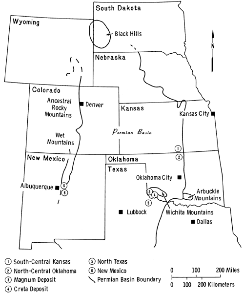
Figure 2--Generalized map showing the distribution of the major rock units in the study area, the locations of surface exposures containing copper mineralization, and the location of the holes drilled as part of this study.
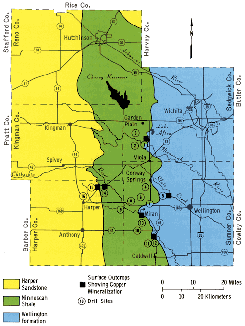
Table 1--Locations of holes drilled as part of the Kansas Geological Survey copper project.
| Drill Hole No. | Drill Hole Location |
|---|---|
| 1 | NW NW Sec. 33, T. 28 S., R. 3 W. |
| 2 | SE SW Sec. 35, T. 28 S., R. 4 W. |
| 3 | SW NW Sec. 11, T. 28 S., R. 4 W. |
| 4 | NW NW Sec. 9, T. 31 S., R. 3 W. |
| 5 | SW SE Sec. 20, T. 31 S., R. 2 W. |
| 6 | NW NE Sec. 30, T. 31 S., R. 3 W. |
| 7 | SW NW Sec. 34, T. 31 S., R. 3 W. |
| 8 | NW NW Sec. 34, T. 31 S., R. 4 W. |
| 9 | SE SW Sec. 12, T. 32 S., R. 5 W. |
| 10 | NE NE Sec. 24, T. 33 S., R. 4 W. |
| 11 | SW SW Sec. 10, T. 34 S., R. 3 W. |
| 12 | NE NE Sec. 10, T. 34 S., R. 3 W. |
| 13 | NE NE Sec. 6, T. 33 S., R. 3 W. |
| 14 | NE SE Sec. 13, T. 31 S., R. 6 W. |
| 15 | NE NE Sec. 9, T. 31 S., R. 6 W. |
| 16 | SW SW Sec. 24, T. 31 S., R. 7 W. |
Based on published information and data derived from examination of cuttings and cores, we will describe in some detail rocks of the Wellington Formation stratigraphically above the middle salt section and those of the Ninnescah Shale. This will provide background information for a discussion of whether to retain the Milan Limestone Member of the Wellington Formation and the Runnymede Sandstone Member of the Ninnescah Shale as identifiable lithologic units. The discussion of the environment of deposition is also based on the interpretation of structures and textures observed in detail in the cores.
Cragin (1897) did most of the original pioneering field work and named many of the formations in the Cimarronian Series of Kansas. Beds between the Wellington Formation and the Salt Plain Formation were assigned to the Harper Sandstones.
On the basis of later field work and utilizing subsurface information, Norton (1937) proposed to restrict the Harper Sandstones primarily to the sandstone formation as exposed at Harper, Kansas. The other part of the section was subdivided by Norton (1937) into four members that, in ascending order, included the Ninnescah Shale, Stone Corral, Chikaskia Sandstone, and Kingman Sandstone. Later, Norton (1939) decided that both the Ninnescah Shale and the Stone Corral merited formation rather than member status. Norton (1939) described the Ninnescah Shale in detail and discussed seven resistant scarp-forming beds consisting of carbonates and sandstones that can be traced for considerable distances in south-central Kansas. He also noted the occurrence of copper carbonate in the first resistant limestone bed above the Milan Limestone Member of the Wellington Formation.The Wellington Formation was originally named by Cragin (1896). Later, Moore (1920) and Bass (1929) expanded the original section and included all the rocks above the Herington Limestone in the formation. It consists essentially of a lower section made up of gray shale and siltstone containing some carbonate lenses and beds. Gypsum and anhydrite are present throughout the Wellington Formation, but weathering and solution have removed this material from near-surface outcrops. The middle part of the Wellington Formation is dominated by the Hutchinson Salt Member. The upper part consists of gray shales and siltstones containing numerous thin beds of carbonates. Drill hole 5 started in the Wellington Formation and penetrated 46.1 m of the unit. Drill holes 1, 2, 3, 4, 7, 10, 11, 12, and 13 started in the Ninnescah Shale, penetrated that unit, and bottomed out in the Wellington Formation. Examination of the drill cuttings and cores has shown that the upper part of the Wellington Formation consists chiefly of shale and siltstone beds along with carbonate beds up to 1 m in thickness. Maximum observed distance between carbonate beds is 4.5 m, but many occur less than 1.5 m apart.
The Milan Limestone Member was described in its type locality by Norton (1939) as consisting of three thin limestone beds containing copper mineralization and separated by maroon and gray shales. Norton (1939) observed that the topmost bed locally weakened and thinned with concomitant strengthening and thickening of the lower beds. The Milan Limestone is indeed clearly exposed in its type section and can, with some confidence, be recognized at 26 m in hole 13, 1.6 km south of its type locality (see Appendix A). However, in no other drill hole can the Milan Limestone Member be identified with any degree of confidence and, hence, the contact between the lowermost Ninnescah Shale and the Milan Limestone Member is problematic and will be discussed as a separate section.
The color of the rock and the occurrence of gypsum need further explanation. In drill holes 1, 2, and 3 the presumed Milan Limestone Member occurs between 6.4 and 10 m deep. The rocks above are mainly reddish-brown while the rocks below, belonging to the Wellington Formation, are almost completely gray. Another noteworthy observation in the Wellington Formation is the common occurrence of gypsum, which composes up to five percent of the rock. Gypsum is found as satin spar in thin veinlets cutting the shales and siltstones at all angles, but with the majority of the veinlets being parallel or subparallel to bedding. Some of the veinlets have been secondarily deformed. Gypsum also occurs in what was referred to by Maiklem and others (1969) as highly distorted, cloudy, felted masses or beds up to 10 cm thick. From the core it is impossible to determine the lateral extent of these gypsum beds. Therefore, it is conceivable that they are masses or pods of limited lateral extent.
To the south and including drill location 4, the top of the Wellington Formation is oxidized and has a reddish-brown color. In the area of drill locations 4 and 5, the first 23 m of the Wellington Formation are oxidized. Farther to the south, in drill hole 11, the same holds true and the depth of the oxidized section may even be greater. Coupled with this is the near-total absence of gypsum in the oxidized and nonoxidized shale and siltstone in this area.
Anderson (1941) discussed the change in color from red to gray in Pennsylvanian and Permian sediments from south-central Kansas into north-central Texas. He believed that the oxidation southward along strike of progressively older sediments in Kansas was the result of an east-west-trending downwarp in Oklahoma. This downwarp was active during deposition of the nonmarine sediments that were derived from an easterly source. He also attributed the alternation of red and gray units to interfingering marine and nonmarine wedges. Thus, be implied that the coloration of the rock is of primary origin and directly relatable to marine or nonmarine supratidal conditions.
The Ninnescah Shale is about 130 m thick near the Oklahoma border and thins to about 85 in, 80 km farther north (Norton, 1939). At the Nebraska border the formation is only 15 m thick. The best exposures are found on the banks of some rivers and creeks. In outcrop the Ninnescah Shale consists mainly of reddish-brown shale and siltstone, with minor intercalated gray units. The shales and siltstones in places are calcareous or dolomitic and often show characteristic spherical greenish-gray spots (up to 1 cm in diameter). Occasional silty dolomites, calcareous sandstones, and rarely silty limestones have also been described by Norton (1939) and Swineford (1955).
Examination of the drill cuttings and core made it possible to get a better idea of the characteristics of the units in the subsurface. Two of the drill holes (14 and 8) started and bottomed out in the Ninnescah Shale. Two additional drill holes (15 and 16) started in the Harper Sandstone and bottomed out in the Ninnescah Shale. Ten of the drill holes started in the Ninnescah Shale and bottomed out in the underlying Wellington Formation. The cuttings from each hole were described and the results plotted (Appendix B). Correlation of individual units between drill holes is impossible. However, on the basis of the position of the drill holes as well as information on the regional dip of the units, we presume that all or nearly all of the Ninnescah Shale Formation was penetrated and sampled in one location or another.
Overall, the Ninnescah Shale consists of about 80 to 90 percent reddish-brown shale and siltstone. Color variation due to the degree of oxidation varies considerably; however, no systematic changes are observable. Light- and dark-gray shale and siltstone make up about 10 to 20 percent of the unit. The thickest gray interval encountered is only 1.5 m, while most gray units are less than 0.3 m thick. The gray units generally are distributed fairly evenly throughout the reddish-brown units. The thickest continuing reddish-brown unit measured about 5.8 m. Lateral variations taking place within a few hundred meters are very common. Swineford (1955) observed rapid lateral changes in Secs. 12, 13, and 14, T. 35 S., R. 3 W. in Sumner County but, during the course of field work in connection with this report, these changes were observed in many localities.
Gypsum, in the form of satin spar and highly distorted, cloudy, felted masses, which at times are intermixed with shale, occurs throughout the Ninnescah Shale, but makes up less than two percent of the unit. Commonly, the shale or siltstone surrounding the gypsum is not oxidized. Satin spar gypsum generally occurs as layers parallel to the bedding. Individual gypsum layers are commonly on the order of 0.5 to 1.0 cm thick.
In the lower 15 to 23 m of the interval, carbonate ledges up to 0.3 m thick start to appear. The carbonates are either limestone or dolomite and are generally argillaceous. A carbonate ledge generally contains a thin interval made up of lithographic or very fine grained material, a unit of coarser argillaceous material that at times is broken up and intermixed with shale, and an interval of alternating thin carbonates and thin wavy shale partings that may or may not be continuous. Some of these carbonates contain copper mineralization.
Runnymede Sandstone Member: The Runnymede Sandstone Member is represented by a 2.1 to 2.4 m thick, blue-green to gray, shaly sandstone with interbedded red shale and sandstone as found in its northernmost outcrop directly below the Stone Corral Dolomite (Norton, 1939). According to Norton (1939) this unit also has been identified in well cuttings in Pratt, Stafford, Ellis, Rooks, Osborne, Russell, and Ellsworth counties in central and northwest Kansas. The Stone Corral Dolomite is exposed in the north-central part of Kingman County. Farther to the south it is replaced by a red dolomitic shale that cannot be distinguished from the overlying and underlying units (Lane, 1960). Norton (1939) also remarked that the Stone Corral Dolomite disappears as a lithologic entity to the south and is replaced by a 1.8 m maroon shale that overlies the Runnymede Sandstone. Excellent exposures of the Runnymede Sandstone section are present near the town of Runnymede in Harper County, according to Norton (1939). He remarked that the beds are in a gradational facies with exposures extending up to the Chikaskia Sandstone Member of the Harper Sandstone (p. 1773). Swineford (1955) described a Runnymede exposure in NE SE Sec. 10, T. 31 S., R. 6 W. and referred to it as occurring in Norton's type area. Examination of outcrops and well cuttings from drill holes 15 and 16 confirms the statement made by Lane (1960) that recognition of the Runnymede Sandstone as a lithologic entity in southern Kingman County and farther south is virtually impossible.
The Harper Sandstone was subdivided into the older Chikaskia Sandstone Member and the younger Kingman Sandstone Member by Norton (1939). Drill holes 15 and 16 were started in the Chikaskia Sandstone and penetrated 10 to 12 m of mainly red shale and siltstone with minor amounts of fine- to medium-grained sandstone. No copper mineralization has been reported from the Harper Sandstone and none was encountered during this study.
The contact between the Wellington Formation and the overlying Ninnescah Shale in the general vicinity of Milan, west of the town of Wellington, was first described by Cragin (1897). He considered the contact to be at the point of change from gray to red units. Norton (1939) re-examined the outcrops and agreed with Cragin's observations. In addition, he noted a 0.3 m greenish to gray, platy, dense limestone containing abundant copper carbonate staining at or near the contact. This limestone bed, best exposed near the southeast corner of Sec. 30, T. 32 S., R. 3 W. along the south bank of the Chikaskia River, was named by Norton (1939) the Milan Limestone Member of the Wellington Formation. Norton mentioned another excellent exposure of the Milan Limestone in the SW SW Sec. 9, T. 28 S., R. 3 W. about 42 km north of the type exposure. According to Norton (1939) three calcareous beds occur in the top one meter of the Wellington Formation. These beds show local variations in thickness and copper carbonate content. Because of these relations, Norton (1939) included all three calcareous beds in the Milan Limestone Member.
In summary, the upper contact of the Wellington Formation consists of three thin carbonate units containing copper minerals within a 2.4 m shale interval, with the gray shales of the Wellington Formation below and the red shales of the Ninnescah Shale above.
As mentioned earlier, Anderson (1941) observed that in a southward direction progressively older sediments are oxidized; therefore, the contact between the Wellington Formation and the Ninnescah Shale is difficult to pinpoint on the basis of color, except at the type locality near Milan (southeast corner of Sec. 30, T. 32 S., R. 3 W.) where the presumed contact is well exposed. If one assumes that the carbonate units form the contact between the two units, although they vary in thickness and even disappear, then the top of the Wellington Formation becomes progressively oxidized in a southward direction from Milan. If, on the other hand, the color change from gray to red marks the contact, then some of the carbonate ledges occur within an oxidized section and should be interpreted as occurring in the Ninnescah Shale. Information derived from the drill holes allows for a better evaluation of the nature of the contact between the Wellington Formation and the overlying Ninnescah Shale.
Since the carbonate beds and the oxidation state of the rocks are important factors relating to the contact, details concerning the nature and number of carbonate beds present and the depth of oxidation of the rocks are presented in the section on detailed subsurface information. The more important findings are summarized here.
In the northern part of the area in Sedgwick County (drill holes 1, 2, and 3) the change from oxidized to non-oxidized material takes place at a depth of 10.7 to 19.2 m. In the southern part of the area near the Oklahoma border the rocks penetrated by the drill holes are oxidized to a depth of at least 50 m in drill hole 10. On the basis of the foregoing discussion and examination of the logs in Appendix B, we conclude that progressively older units are oxidized to the south. This conclusion is also partially based on the observation that to the south more of the carbonate units occur within oxidized shale. Therefore, the change in color cannot be used as the exact boundary between the Wellington Formation and the Ninnescah Shale. Furthermore, we believe that much of the oxidation is not of primary origin, as will be discussed in the section on environment of deposition of the Ninnescah Shale.
Most of the carbonate units we encountered and sampled consist of dolomite. At least 15 carbonate beds are recognized in one hole (5) in the Wellington Formation and at least five in what may be the lower Ninnescah Shale. Copper and iron sulfide mineralization occurs in many of the carbonate units of the Ninnescah Shale as well as in those that probably belong to the Wellington Formation. These mineralized beds are from all appearances not continuous and occur at different depths. The same can be said of the non-mineralized beds and, except for drill hole 13, 1.6 km south of the type section where the equivalent Milan Limestone may be recognized, it is impossible to correlate with any degree of certainty a specific carbonate bed in any one drill hole with that at the type locality. Norton (1939) and Walters (1961) alluded to the inconsistent nature of the carbonate beds. Therefore, the Milan Limestone Member does not serve a useful purpose but actually tends to cause confusion in the field. We suggest dropping this member as an official unit, although this leaves us with the problem of not having a fixed and easily recognizable boundary between the Wellington Formation and the overlying Ninnescah Shale.
The transition from Wellington Formation rocks to those of the Ninnescah Shale is characterized by a diffuse and irregular oxidation boundary and by the cessation of deposition of irregular carbonate units. The transition zone is judged to be about 40 m thick in the area studied.
To the south across the Oklahoma border, the Wellington Formation is overlain by the Garber Sandstone (Fig. 3). The Upper Shales Member of the Wellington Formation (Cox, 1978) consists mainly of shale with minor siltstone and thin carbonate and evaporite units. In the northern counties of Oklahoma the oxidation of the shales also affects progressively older units, from the middle of the Upper Shales to near its base, as one goes farther south.
Figure 3--Stratigraphic column of the Lower Permian Series of Oklahoma.
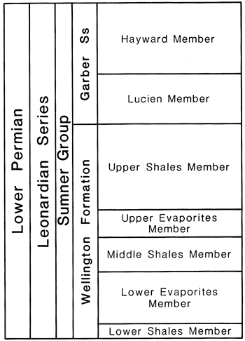
The Milan Limestone Member is not recognized in Oklahoma. The Lucien Member of the Garber Sandstone overlies the Wellington Formation and consists mainly of red shale with some interbedded sandstones. The lowest recognizable sandstone on the surface is considered to be the contact. However, in the subsurface the contact is difficult to establish, partially because of the pinching out of these sand bodies to the north.
Cox (1978), in studying the copper occurrences in the subsurface in north-central Oklahoma, also came to the conclusion that a transition zone formed the boundary between the Wellington Formation and the overlying Garber Sandstone.
In Kansas the Permian rocks in question are not exposed at the surface north of the area studied, and no drill core is available to study these rocks in the subsurface.
The Stone Corral Formation is an excellent marker unit composed of dolomite, anhydrite, gypsum, and salt recognizable both in the subsurface and on the surface. It attains a thickness of about 10 m in the subsurface, but in outcrop it generally is no more than 2 m thick because of the dissolution of evaporite minerals. South of the Arkansas River the unit becomes progressively less developed and cannot be recognized south of Rice County. As discussed in the section on stratigraphy, Norton (1939) named the Runnymede Sandstone Member of the Ninnescah Shale as occurring directly below the Stone Corral Formation. It is a sandy unit that Norton (1939) recognized in a few places. He admitted that the character of the unit changes along strike, and in the type area be described the rocks as being in gradational facies. In later years, despite field work conducted by several geologists (Swineford, 1955; Bayne, 1960), the member has never been traced with any degree of certainty away from the type area. Examination of electric logs will readily convince anyone that the unit is not detectable in the subsurface. Therefore, it is doubtful that the unit can be traced southward into Oklahoma and northward in the subsurface as Norton (1939) believed. At the localities mentioned by Norton, sand or sandy siltstone beds are indeed exposed, but it is doubtful that they are the same bed. The only indication that one is dealing with the Runnymede Sandstone Member is that the rock occupies a position below the Stone Corral marker bed. In drill holes 15 and 16 the Runnymede Sandstone Member cannot be identified with any certainty 2 to 3 km west of the type area. Therefore, we suggest dropping the Runnymede Sandstone Member as a stratigraphic unit.
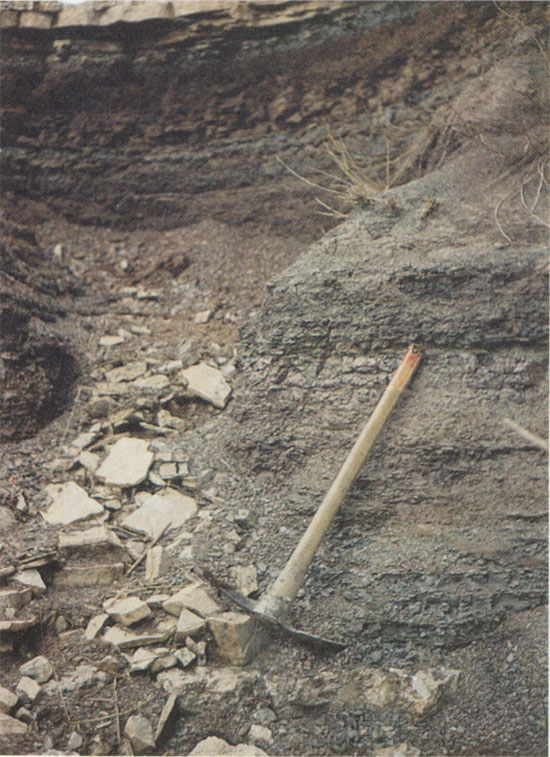
Subsurface information obtained from the drill holes allows a better evaluation of the contact between the Wellington Formation and the Ninnescah Shale. The type section measured by Swineford (1955) is reproduced as Table 2. It shows the three carbonate ledges within the 2.4 m shale interval. Two of the ledges are easily distinguishable in a photograph taken at the locality (Fig. 4). Drill hole 13 (elevation 378 m) was drilled approximately 1.6 km due south. Accounting for the difference in ground elevation and assuming no dip to the south of the beds, one might expect the Milan Limestone to occur at an approximate depth of 15.3 m. A core taken at that depth (see Appendix A) indeed shows a 7 cm-thick limestone unit at 14.99 m and a second 10 cm-thick dolomitic limestone unit at 15.67 m. The top unit also contains malachite grains and stains in vugs and along fractures. The red shale unit between the two carbonate beds is 61 cm thick, which is approximately the same as the distance between the lower two carbonate units in the type area. The third or upper carbonate unit, which Swineford (1955) reported at 2.04 m above the top unit, was not recorded in the cuttings. The rock recovered in this section of the core was reddish-brown.
Table 2--The type section of the Milan Limestone Member of the Wellington Formation in Sumner County, Kansas (SE SE, Sec. 30, T. 32 S., R. 3 W.), measured by Ada Swineford (1955).
| No. | Description | Thickness (feet) |
|---|---|---|
| Ninnescah Shale | ||
| 12 | Clay shale--blocky, noncalcareous, dark reddish-brown (2.5YT3/4) | 0.5 |
| 11 | Limestone--dolomitic, argillaceous, light-gray | 0.7 |
| 10 | Clay shale--calcareous, blocky, light greenish-gray | 0.4 |
| 9 | Clay shale--blocky, dark reddish-brown | 3.3 |
| 8 | Clay shale--blocky, maroon | 1.4 |
| 7 | Clay shale--dark-gray and dark-maroon | 1.6 |
| 6 | Limestone--very argillaceous, gray | 0.3 |
| 5 | Clay shale--blocky, dark-maroon | 1.1 |
| 4 | Clay shale--blocky, dark-green and some maroon | 0.7 |
| Wellington Formation--Milan Limestone Member | ||
| 3 | Limestone--dolomite, white or yellowish-gray (5Y8/1); contains malachite, pink celestite, and barite | 0.9 |
| 2 | Clay shale-grayish-green | 0.4 |
| 1 | Covered to stream | 10 |
Figure 4--The type location of the Milan Limestone Member of the Wellington Formation. The lower limestone bed is just below the pick. The middle limestone is at the top of the pick handle and the upper limestone bed can just be seen in the upper left hand corner of the photograph.
A second core was taken from 25.91 m to 29.87 m. Several thin carbonate units were encountered in the interval between the two cores. In the lower core, three additional carbonate units were encountered. The uppermost unit at 26.11 m consists of dolomite and is 28 cm thick. Sulfide mineralization is found throughout this unit. A gray shale unit 11 cm thick overlying the carbonate contains a "chalcocite-like" mineral phase that is a form of copper sulfide. (The nature of this copper sulfide is fully explained in Part 2 of this publication, which deals with the mineralogy.) The middle unit consists of a limestone bed 15 cm thick at 26.49 m and also contains copper mineralization. The lowermost unit at 28.80 m, 26 cm thick, consists of limestone containing pyrite and a "chalcocite-like" phase. In addition, barite mineralization is found in this interval. Gypsum was first observed in the core at 25.98 m and at several lower intervals. It occurs as satin spar bands, generally less than 2.5 cm thick, filling in fractures and as highly distorted, cloudy, felted masses or beds intermixed with varying amounts of shale. Again, most of the interval is oxidized. Thus, in summary, the following observations can be made at drill location 13, 1.6 km south along strike from the type locality:
Therefore, color of the rock, presence of carbonate units, and copper mineralization cannot be used in combination to establish the contact between the Wellington Formation and the Ninnescah Shale.
At drill location 10 (elevation 378.5 m), three cores were extracted (see Appendix A). The first carbonate unit encountered was a 10 cm limey dolomite at 32.16 m, containing sulfide mineralization. A second carbonate unit, 10 cm thick, consists of dolomite and occurs 1.95 m below the first. Sulfide mineralization is also present in this unit. Two more mineralized dolomite units were encountered in a core from 42.67 m to 47.09 m. At least three more thin carbonate units were logged between the second and third core; however, it was not established whether the units consisted of limestone or dolomite or whether they were mineralized. In the second and third core, gypsum in the form of thin (up to several centimeters) satin spar bands filling fractures and as highly distorted, cloudy, felted masses intermixed with shale makes up about the same volume as the carbonate. As a whole, because of their color, the rocks down to the total depth of 49.5 m can be considered oxidized. The shales on either side of the gypsum and carbonate beds are generally not oxidized and retain their gray color.
Drill location 12 (elevation 358 m) was spotted about 0.8 km west of the approximate contact between the Wellington Formation and the overlying Ninnescah Shale (Walters, 1961), and drill location 11 (elevation 372 m) was located 2.4 km west of the contact. Assuming a regional dip of the beds of about 4.5 m to the west, the first carbonate unit should occur at about 10.7 m depth in drill hole 12. Indeed, at 10.7 m, a 7 cm-thick dolomitic limestone was encountered containing malachite mineralization. At 11.30 m, a second carbonate bed is present, consisting of argillaceous dolomitic limestone 8 cm thick and showing malachite mineralization. Separation between the two units is 0.53 m. A third core showed an unmineralized dolomite bed 7 cm thick at 17.89 m. just above this dolomite bed some gypsum was encountered. Again, the rock section to the total depth of 19.8 m is oxidized.
At drill location 11 (elevation 372 m) we expected the first carbonate unit to appear at about 28.3 m. Instead, a comparatively thick (0.73 m), partially oxidized, non-mineralized dolomite bed occurs at 10.82 m. This unit also contains conchostracans (clam shrimp). A second non-mineralized carbonate unit of dolomitic limestone, 33 cm thick, occurs 1.62 m below the first unit. Three more cores were taken at greater depths to study additional carbonate beds. These units consist either of dolomitic limestone or dolomite, and only the dolomite unit at 31.77 m showed copper mineralization. Gypsum was found in all four cores and possible barite mineralization occurred in a gray shale at 13.81 m. Conchostracans (clam shrimp) also were found at 26.67 m in a gray shale containing dolomitic silty laminae. Again, except for the areas surrounding and including the carbonate and gypsum units, all of the material is oxidized to the total depth of the hole at 32.3 m.
Based on observations of cored material and cuttings from drill holes 10, 11, 12, and 13, we conclude that the color change from oxidized to non-oxidized material cannot be used to establish the contact. The Milan Limestone Member exposed in the type area may be recognized in drill hole 13, but cannot be recognized in the other holes with any degree of certainty.
In the following section the information gained from the drill holes farther to the north will be evaluated.
Drill hole 5 was started in the Wellington Formation based on mapping by Walters (1961). To a depth of 14.6 m the rocks are predominantly oxidized. Two non-mineralized carbonate beds were encountered in the core; one is an 8 cm-thick dolomitic limestone bed at 9.14 m and the other a dolomite and dolomitic limestone 23 cm thick at 9.40 m. Below 14.6 m, to the total depth of the hole at 41.1 m, only two thin red units were encountered. However, at least 16 thin carbonate beds occur below the cored interval. Unfortunately, it could not be established whether any of these units were mineralized. Assuming a regional dip of the beds of about 4.5 m to the west, we expect the contact between the oxidized and nonoxidized units at drill location 7 to occur at about 33.5 m; however, the change takes place at 18.9 m. Three cores were extracted from the hole and they contained six carbonate units. A 16 cm-thick limestone bed, showing copper mineralization, was encountered at 5.92 m. Two centimeters of non-mineralized limestone were found at 7.15 m, 1.23 m below the first unit. Two dolomitic limestone units, at 16.29 and 16.97 m depth, are both mineralized. Gypsum occurs in the section below 17.1 m.
Drill location 4 was located 7.2 km north and 1.6 km west of location 7, close to the mapped contact between the Wellington Formation and the Ninnescah Shale (Walters, 1961). Assuming that the oxidation boundary would not vary drastically, we expect it to occur at about 22.9 m depth. However, the hole was drilled to a total depth of 46.2 m and penetrated only oxidized material. Three carbonate units at 8.8 m, 14.0 m, and 14.6 m were recognized in the cuttings. Three more carbonates were sampled in the core. A 23 cm limestone bed containing mineralization was encountered at 36.78 m. The second and third carbonates are thin (7 cm) non-mineralized dolomitic limestones occurring close together at 38.01 m and 38.18 m. Highly distorted, cloudy, felted gypsum was recognized in the core and also occurs deeper in the section.
Drill hole 6 bottomed at 36.6 m and drill hole 8 at 45.7 m; both penetrated mainly oxidized shale. However, gypsum occurred throughout the section in both holes. No carbonate units were recognized in the cuttings.
Toward the north, drill location 1 was located 1.6 km west of the contact with the Ninnescah Shale. This is about 3.2 km south of the location mentioned by Norton (1939) as showing an excellent exposure of the Milan Limestone Member. At drill location 1 (elevation 411.5 m) the rocks are oxidized to a depth of 10.7 m. At 6.4 m, a thin carbonate bed was encountered during drilling. Two cores were recovered from this hole. At 8.75 m, a 47 cm-thick dolomite bed containing malachite mineralization is present. A second dolomite unit 8 cm thick was encountered at 9.52 m, only 30 cm below the upper dolomite. In the second core one limestone and two dolomite beds were sampled, neither containing copper mineralization. One additional carbonate bed was encountered between the two cores. Highly distorted, cloudy, felted gypsum mixed with shale and gypsum as satin spar in fractures is common in the unoxidized portion of the section below 10.7 m.
Drill hole 2 (elevation 408.4 m) was located 5.6 km west and 1.6 km south of drill hole 1. The rocks are oxidized to a depth of 19.5 m. Three cores were recovered from the hole. Two carbonate units occur just above the interval from which the first core was taken. In the first core a 16 cm non-mineralized limestone bed occurs at 12.34 m. A second non-mineralized dolomite bed, 1.24 m deeper and 9 cm thick, occurs at 13.74 m. A 1 cm-thick satin spar gypsum bed occurs above the dolomite unit. Below this interval gypsum is quite common in the section and in places makes up several percent of the rock. Between the first and second, between the second and third, and below the third cored interval, several additional carbonate beds were encountered. Two mineralized dolomite beds were sampled in the second core.
At drill location 3 (elevation 411.5 m), 7.2 km north of drill location 2, the change from oxidized to non-oxidized shale takes place at 14.3 m. One core containing four mineralized carbonate units was recovered from the hole. A 25 cm-thick dolomite occurs at 15.82 m, a 6 cm-thick dolomite bed at 18.57 m, and a 10 cm-thick dolomite at 19.15 m. Another carbonate bed was encountered 8.2 m above the cored interval. Gypsum is very common in the non-oxidized portion of the rock. Copper mineralization is not confined to the carbonate units, but also occurs in the non-oxidized shale or carbonaceous shale.
Drill hole 14 (elevation 427 m) was located about 1.6 km southeast of the town of Runnymede and penetrated 23 m of mainly oxidized shale and silty shale in the upper part of the Ninnescah Shale. A few hundred meters north of the drill location, Waugh and Brady (1976) reported copper mineralization in thin argillaceous dolomite beds exposed on the surface. No copper mineralization was recognized in the cuttings or with the aid of a binocular microscope in the core. Some calcareous shale was found in the core. Gypsum was seen in a couple of places in the cuttings, but was not seen in the core. However, solution cavities were apparent in the core.
Drill hole 15 (elevation 448 m) was located just west of the town of Runnymede. The hole reached a total depth of 49 m and was started in Pleistocene sedimentary material. It is not clear whether any Harper Sandstone was penetrated, but the rocks below 11 m probably belong to the Ninnescah Shale. The rocks are mostly oxidized except in the interval from 29 m to 46 m, where oxidized and non-oxidized rocks alternate, each making up about 50 percent. Shale and silty shale are the dominant rock types. Copper mineralization is associated with the non-oxidized bedded and reworked shale. The copper mineralization seen in the core may be equivalent to that described by Waugh and Brady (1976) in outcrop except that only secondary copper minerals are observed in outcrop. Gypsum occurring as satin spar, filling fractures, and as highly distorted, cloudy, felted masses and beds makes up several percent of the rock in the cored intervals. In the core, gypsum is found both in oxidized and non-oxidized shale.
Drill hole 16 (elevation 442 m) was started in Pleistocene sedimentary material and reached a total depth of 46 m. Very fine to fine-grained oxidized sandstone of the Harper Sandstone is found in the upper part of the hole and is sampled in the first core. Neither the Stone Corral Formation nor the Runnymede Sandstone were recognized in the cuttings. The upper part of the Ninnescah Shale was penetrated in the lower part of the hole. The rock consists mainly of oxidized silty shale with some gypsum. No copper mineralization was recorded.
The evaporite deposits of the Hutchinson Salt Member of the Wellington Formation formed in a relatively shallow, restricted, stable basin with little or no sediment input. In south-central Kansas the Sedgwick Basin (Moore and Jewett, 1942) originated in post-Mississippian time and extended south into Oklahoma where it merged with the much larger Anadarko Basin. The Anadarko Basin was bounded on the south by the positive elements of the Wichita and Arbuckle mountains. However, connections with the open sea farther to the south did exist between these positive elements. The nature of the openings, the configuration and depth of the shallow seas beyond, and the amount of evaporation were determining factors influencing the precipitation of the salt.
Still farther to the southwest the Anadarko Basin was bordered by the positive elements of the Amarillo Uplift, the Cimarron Uplift, and the Keyes Dome (Dixon, 1967). To the west the Wet Mountains and the Ancestral Front Range formed the boundary (Mudge, 1967). No major positive tectonic elements bounded the basin to the east and north. The area to the north is known as the Siouxia landmass (Mudge, 1967).
During the time of deposition of the upper Wellington Formation and the Ninnescah Shale, the major tectonic activity was associated with the downwarping of the Anadarko Basin along an asymmetrical northwestward trend, with the greatest movement taking place just to the north of the Wichita Mountains. The basin shallowed markedly in northern Oklahoma and south-central Kansas as evidenced by the observed facies changes. In Kansas fewer carbonate units occur farther to the south and the amount of sandstone in the section increases. South of the Oklahoma border the sediments are mainly derived from the Ouachita, Wichita, and Arbuckle Mountains; while farther north much of the fine sediment may have been derived from the low-lying landmass to the east and possibly the north. Swineford (1955) believed that the Wet Mountains and the Ancestral Front Range in Colorado were also important source areas for much of the sediment in Kansas, especially the coarser feldspathic debris that is more prominent in the red beds above the Ninnescah Shale. Swineford (1955) reported that the Wellington Formation contains no sandstone and only three percent siltstone. The Ninnescah Shale contains less than one percent sandstone and 15 percent siltstone. These figures agree well with what is shown by the cored material.
The rocks of the upper Wellington Formation consist primarily of gray shale with minor interbedded siltstone; thin carbonate ledges or beds; and gypsum in the form of highly distorted, cloudy, felted masses intermixed with shale or thin satin spar fracture fillings.
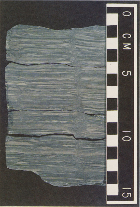
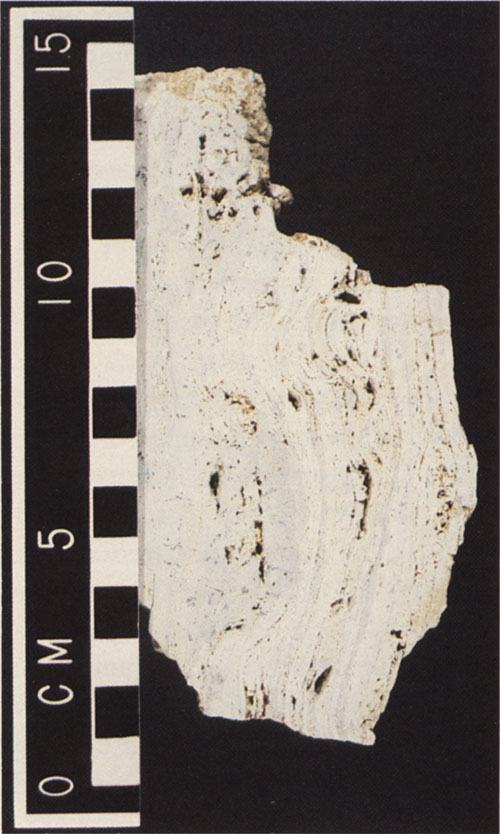
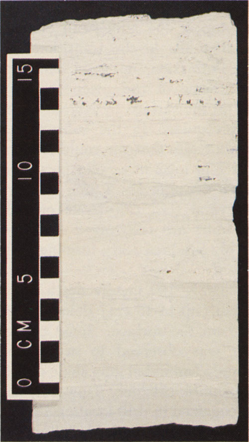
Shale is the dominant rock type. It occurs as massive beds up to 1 m thick showing no internal structure such as bedding, but giving the appearance of having been extensively reworked by organisms. Also common is finely laminated shale and siltstone with individual laminae ranging up to several millimeters thick. The lighter colored siltstone laminae thicken and thin rapidly and are not continuous over even the width of the core. Small-scale cross-bedding and scoured surfaces are commonly observed. Post-depositional higher energy events are evidenced by laminated shale that has been broken up and disturbed to varying degrees (Fig. 5).
Figure 5--Drill hole 3. Core from a depth of 16.77 to 16.90 m. Thinly laminated shale and siltstone. Individual laminae thicken and thin rapidly. Cross-bedding and scour surfaces are common. One large mud crack is shown.
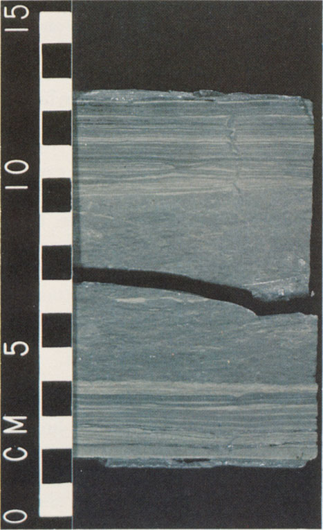
In three of the cores (drill locations 1, 4, and 10) evidence for cyclical deposition is found. At drill location 1 a laminated shale containing thin, discontinuous, lighter colored silty beds is overlain by a reworked shale in which pieces of laminated material are visible (Fig. 6). Both the top and bottom contacts are erosional, and six to seven cycles can be recognized. The units making up a cycle thicken toward the top. The whole interval is 76 cm thick.
Figure 6--Drill hole 1. Core from a depth of 18.63 to 18.75 m. A cyclic sequence of thinly laminated and reworked shale and siltstone. The cyclic sequence shown is one of seven cycles present in this core.
In a core from drill location 4, three cycles can be recognized; these cycles consist of a reworked massive shale 10 to 20 cm thick, overlain by a disturbed laminated shale unit consisting of shale and siltstone 5 to 15 cm thick. Six cyclic sequences can be seen in core from drill location 10. Here a unit consisting of laminated shale and siltstone, which is disturbed and broken up, is overlain by a thinly laminated unit of shale and lighter colored siltstone. The whole interval has a purplish-red color.
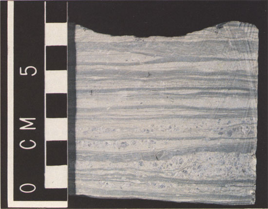
The carbonate beds, which consist dominantly of dolomite with lesser amounts of dolomitic limestone and limestone, contain varying amounts of argillaceous material. A carbonate unit commonly consists of three distinct parts with an upper and lower part that contain varying amounts of shale as stringers, laminae, or thin beds, normally having wavy bedding planes. The middle part of the unit is generally composed of a cleaner, very fine grained to lithographic carbonate. Carbonate clasts surrounded by shale are observed in several of the cores. Secondary vugs and veinlets are common in the carbonates. They are commonly rimmed with euhedral calcite grains and these grains are, in turn, surrounded and partially replaced by younger euhedral quartz crystals (Fig. 7). A second generation of very fine grained quartz is the most abundant mineral phase in the veinlets. This phase corrodes the surfaces of the older, larger euhedral quartz. Cox (1978) found much of the same sequence of minerals in the Wellington Formation of north-central Oklahoma. Algal structures are quite common in the carbonates, but are not recognized in the other sediments (Fig. 8).
Figure 7--Drill hole 11. Core from a depth of 18.79 to 18.92 m. Interbedded reddish-brown shale and creamy, silty, limey dolomite. Secondary porosity is developed Dear the top of the interval.
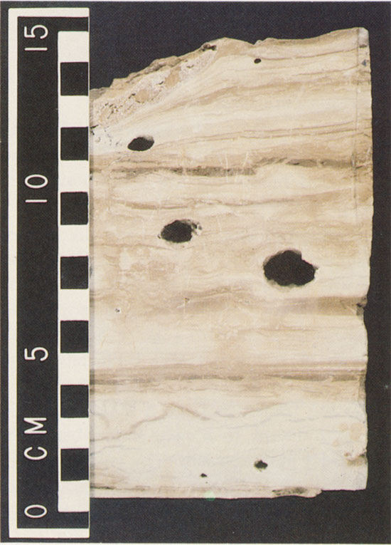
Figure 8--Algal structure in a carbonate unit. Specimen collected at the type locality of the Milan Limestone Member (SE SE Sec. 30, T. 32 S., R. 3 W.).
Copper mineralization is often associated with the vugs or veinlets in the carbonates (Fig. 9). Barite is another common secondary mineral found in the carbonate units, although it is not exclusively restricted to the carbonates.
Figure 9--Drill hole 10. Core from a depth of 44.12 to 44.30 m. Copper sulfide mineralization (dark mineral in the interval 10-15 cm) in a dolomite concentrated along bedding planes and filling small desiccation cracks. The copper sulfide is a "chalcocite-like" phase consisting of anilite-djurleite.
Gypsum is recognized in every core taken from a depth greater than 14 m. Primary gypsum occurs as highly distorted, cloudy, felted masses or beds intermixed with shale (Fig. 10) and is never found in the oxidized portion of the core. It also occurs as distinct small, rounded aggregates within some of the silty laminae where it is interpreted as having grown in situ after deposition of the rocks (Fig. 11).
Figure 10--Drill hole 3. Core from a depth of 17.22 to 17.43 m. A highly distorted, cloudy, felted mass of primary gypsum intermixed with shale. The gypsum formed at a time when a change in the environment of deposition took place as evidenced by the light-colored, more silty shale followed by the gypsum and much darker shale and siltstone.
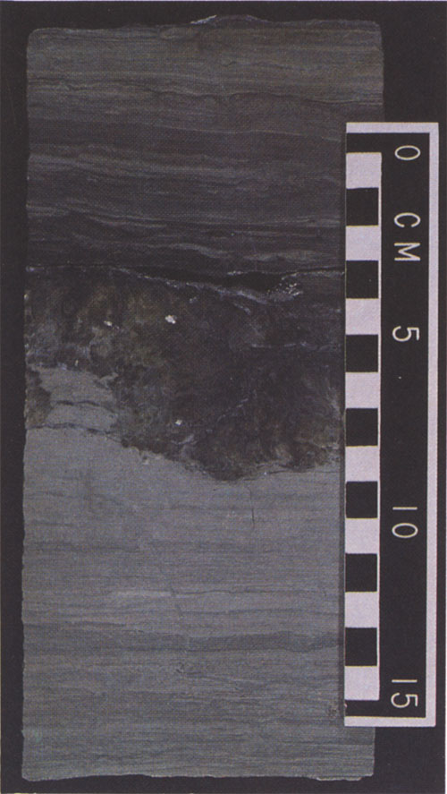
Figure 11--Drill hole 4. Core from a depth of 38.09 to 38.16 m. Small rounded aggregates of gypsum concentrated in the more silty portion of the core (0-3 cm). The gypsum grew in situ after deposition of the material.
Satin spar gypsum occurring as stringers and thin layers a few millimeters thick is interpreted as being of secondary origin. Some of these stringers were at a later time either plastically deformed or mechanically broken and displaced.
Clam shrimp (Cyzicus) were recognized at a depth of 10.8 m in a core from drill hole 11.
Shale that is salty to the taste is present in a core from drill location 2. Mud cracks, soft sediment deformation, and burrowing are also common features observed in the core (Fig. 10).
Only the upper half of the Wellington Formation above the Hutchinson Salt Member was penetrated. However, from examination of the core and cuttings and from descriptions of surface outcrops by Swineford (1955), a fairly good idea of the type of sediments and their environment of deposition can be deduced. This part of the section represents the transition from a highly saline, deeper marine environment to a near-shore, brackish-water, and supratidal environment.
The type of sediment brought into the basin, mainly shale, indicates that the surrounding landmass supplying the material was relatively flat and low in elevation. The average thickness of the individual laminae suggests that the amount of sediment supplied to the basin was relatively small and may have been influenced by cyclical events related to seasons. The water in which this material was deposited was relatively shallow and at times exposed to the air for short periods of time. Periodic storms generated higher energy levels, which caused the disruption and reworking of previously deposited sediment. At times carbonate deposition was initiated in parts of the shallow basin, either because the water became supersaturated with calcium carbonate or the environment became favorable for the proliferation of organisms (algae). Most of the carbonate is quite argillaceous and shale stringers commonly occur in the carbonate. These stringers could effectively stop the carbonate build-ups for short periods of time. At more or less regular intervals the water became supersaturated with respect to gypsum, which crystallized in shallow water intermixed with the soft mud. At times both the carbonate and the gypsum beds were broken up as a result of wave action generated by storms. Some of the broken material was reworked and deposited elsewhere (e.g., drill location 1--19.19 m). It is also not uncommon to find gypsum in the carbonate.
In summary, the sea in which the sediments were deposited was mostly shallow. At times the water retreated, leaving the sediments exposed to the air. The water must occasionally have become supersaturated with respect to gypsum and carbonate, probably as the result of high evaporation rates. Influx of fresh water from the land or of saline water from the open ocean to the south diluted the water enough to cause cessation of gypsum and carbonate precipitation. The primary carbonate deposited in this environment is believed to have been limestone, which was later dolomitized by magnesium-rich brines. These brines also created the secondary porosity. However the direct precipitation of proto-dolomite cannot be ruled out. The calcium released may have combined with the sulfate in the water to produce the secondary gypsum deposits that occur in the form of satin spar related to fractures and other open spaces. Similar textures have been described by Kendall (1979) in discussing facies models of subaqueous evaporites.
The rocks of the Ninnescah Shale consist primarily of reddish-brown oxidized shale. The degree of oxidation and the amount of iron present provide for a wide range of reddish-brown colors. Even though reddish-brown shale makes up 80 to 90 percent of the section, no continuous oxidized shale unit thicker than about I m was encountered in the core. The oxidized parts are interrupted by thin (up to 0.5 m), generally dolomitic or limey gray units. Silty shale and/or siltstone become more prominent toward the top of the Ninnescah Shale. Except for the carbonate units in the transition zone with the Wellington Formation, no good carbonate beds are recognized. None of the seven scarp-forming beds recognized on the surface by Norton (1939) can definitely be recognized in the subsurface. Swineford (1955) was not sure that she could recognize Norton's beds 1 and 2 in a 32 m section measured near Bluff Creek (Secs. 12 and 13, T. 35 S., R. 3 W.) in Sumner County. Several thin calcareous or dolomitic gray silty shale units are recognized in the core. These could possibly produce scarp-forming beds if exposed to the air.
Approximately 100 meters north of drill location 14 a few thin (up to 15 cm) dolomitic siltstone beds are exposed on the surface. Some copper carbonate (malachite) was observed to occur along bedding planes in thinly laminated gray shale closely associated with the dolomitic siltstone. However, no mineralization was recognized in drill location 14. Mineralization in the top of the Ninnescah Shale was recognized in cores from drill hole 15. Gypsum occurs all through the Ninnescah Shale as highly distorted, cloudy, felted masses or beds intermixed with shale and as satin spar filling fractures.
Examination of the drill cuttings and cores shows that the Ninnescah Shale contains less gypsum than the upper part of the Wellington Formation and that more gypsum occurs as satin spar. We believe that, as a result of oxidation, gypsum was removed from the rocks and some was subsequently precipitated as satin spar in fractures. It is not known how much gypsum was removed from the section; thus, not much can be said about the original gypsum content of the rocks. The textures observed in the cores of the Ninnescah Shale are consistently similar to those observed in the Wellington Formation. Thinly laminated, massive, reworked, or broken-up shale and siltstone are common. The laminae are made up of discontinuous and wavy siltstone and exhibit cross-bedding and scour features.
The environment of deposition for much of the Ninnescah Shale was the same as for the upper part of the Wellington Formation, except that water depths were probably even less. The rocks were laid down in a very shallow, possibly lagoonal environment. The amount of silt increases toward the top of the Ninnescah Shale, possibly indicating a different source of some of the material. Swineford (1955) suggested a western source in the Wet Mountains and the Ancestral Front Range of Colorado as a possibility. It was earlier noted that oxidation affected progressively older rocks in a southward direction. For several reasons, we believe that much of the oxidation is the result of post-depositional processes.
There are no primary bedding features, indicating that the red shales were deposited in an environment different from the gray shales. There is no difference between the mineralogy of the oxidized and nonoxidized beds. The shale, the predominant material, consists mainly of illite and chlorite with minor amounts of quartz and feldspar, indicative of deposition under marine conditions. Chemical analyses of red and gray shales (Swineford, 1955) show no difference in the amount of iron oxide (Fe2O3) present.
X-ray diffractometer patterns obtained from red shales did not show any hematite peaks (Lambert, 1979) but the shales did have a high background between 15° and 20° 2θ. X-ray diffraction reflections of some of the brightest red shales show weak hematite reflections on material of less than two microns (Swineford, 1955).
Consistently, we observed that in a laminated gray shale the slightly more porous silty laminae oxidized preferentially over the less porous adjoining gray shale laminae. Highly distorted, cloudy, felted masses of gypsum intermixed with shale, which is interpreted to be deposited in a shallow-marine environment, also are observed to be secondarily oxidized.
A secondary post-depositional oxidation process easily explains the presence of gray shale and gypsum beds at regular intervals throughout the top of the upper part of the Wellington Formation and the Ninnescah Shale. In the material examined, the gypsum beds and the surrounding shale generally are the last to be oxidized, and sulfide mineralization is restricted to non-oxidized shales. We suggest that the shales, at some time after deposition, were oxidized by meteoric water containing enough oxygen for the process to take place.
The Lower Permian Wellington Formation, stratigraphically above the Hutchinson Salt Member, and the Ninnescah Shale mainly represent a series of fine clastic sediments deposited in a slowly emerging basin. It is believed that the basin floor was not subjected to rapid fluctuations as a result of tectonic processes and that the rate of infilling by sediments slightly exceeded the general subsidence of the basin floor, resulting in the deposition of supratidal and continental-type sediments in middle Cimarronian time. The occurrence of thin carbonate beds that do not extend much beyond the Oklahoma border toward the south suggests that the sediment supply was not continuous throughout time.
There is no consensus of opinion on the source of the copper that gave rise to the numerous deposits associated with the Permian sediments in the Midcontinent region. La Point (1979) considered areas uplifted during Permian and Triassic time and underlain by Precambrian metavolcanics as possible sources for the sandstone copper deposits in New Mexico.
The copper deposits in north Texas and south Oklahoma have received much attention. The origin of the copper has been attributed to several sources such as the igneous rocks forming the core of the Wichita (Al-Shaieb and others, 1976) and Ouachita mountains (Cox, 1978; Fay, 1975), groundwater involved in an evaporative sabkha-like setting, or watery solutions having varying chloride concentrations from some deeper source, possibly driven by heat associated with anomalous geothermal gradients (Smith, 1974). These are by no means all the ideas put forward on the basis of the information available. However, a few characteristics common to most deposits stand out and are mentioned by most workers. They are:
The Kansas deposits are much the same except that they are zoned. The paragenetic sequence discussed in Part 2 of this bulletin indicates that there is a decrease in copper content of the mineralizing fluid as distance away from the source of copper increases (Ripley and others, 1980).
We offer a general descriptive explanation for the accumulation of anomalous copper concentrations in certain non-oxidized restricted sedimentary units. During the time of deposition of the Hutchinson Salt Member, the amount of copper dissolved in sea water may have been greater than normal because of the large chloride concentrations. As the salinity decreased with time, copper precipitated from solution and was adsorbed on the clays that were brought into the basin. Copper may also have been extracted by algal material that flourished in places in the shallow sea. Fluctuations in the amount of sediment input and the amount of fresh water flowing into the sea, coupled with the rate of evaporation, caused certain portions of the sedimentary package to be more copper-rich than other parts.
We view the subsequent process of concentrating copper in definite horizons as a late diagenetic process after lithification of the rocks, whose precise timing does not seem to be of critical importance. At some time after the rocks were deposited, the sea withdrew and the rocks were subjected to the action and reaction of meteoric water. The water carried enough oxygen to oxidize the sediments while dissolving chlorides and other salts present in the rocks. This solution also solubilized part or all of the adsorbed copper. According to Rose (1976), copper chloride complexes in a fluid at temperatures below 75°C probably played an important role in the formation of these types of copper deposits. A study by Ripley and others (1980) attempted to show, on the basis of theoretical calculations, that the observed mineralization may have resulted from the reaction of copper chloride solutions at near-neutral pH with pyrite. We propose that the oxygen present in meteoric water was used to oxidize the sediments and, as the oxygen was slowly depleted, the copper was precipitated at appropriate sites nearby. This explains why copper mineralization is only found in the non-oxidized parts of the section. This same solution probably also was responsible for the dolomitization of the limestone. The meteoric water traveling basinward or downdip through the sediments followed definite pathways. The more silty material is oxidized preferentially over the shaly material as a result of its higher pemeability. Vertical transport of materials was essentially nonexistent. The typical sequences of oxidized red units interbedded with thinner non-oxidized units (drill locations 6, 8, and 10) are the expected result. The observation that the copper concentrations diminished away or downdip from the presumed surface is also in accord with the proposed mechanism.
The ultimate source of the copper may well be the igneous rocks to the south and west of the Permian Basin. However, another possible source of the cop- per, which has not been considered before, is the Keweenawan basalt of the Central North American Rift System (CNARS). The mafic rocks of the CNARS are exposed in the Lake Superior region and can be traced at increasing depth into central Kansas. It is generally believed that the CNARS extends southward into Oklahoma. During Permian time the basaltic rocks in Kansas were covered by sediments up to 650 m thick. The mafic rocks could be the source of the copper. Saline solutions could have had access, along major faults, to the mafic rocks and could have leached copper from them. Alternatively, copper may have been leached from an existing copper deposit or deposits associated with the basaltic rocks. Any geothermal or hydrothermal activity that may have occurred, although we do not have any evidence of this, could have substantially assisted in the process of introducing copper-rich solutions into the Permian basin. Major copper deposits in the central United States associated with Keweenawan mafic rocks occur in northern Michigan (White, 1968; Ensign and others, 1968). Another reason that the Keweenawan mafic rocks are favored as a source is the monomineralic nature of the occurrences. If a variety of intrusive rocks such as those found in the Wichita Mountains were the source, one might expect the deposits to have more of a polymetallic nature. Associated with the CNARS are north-northeast- and northwest-trending major faults that show substantial movement into Late Pennsylvanian time. Geophysical evidence indicates that many of these faults are still active today (Berendsen and others, 1980).
The findings reported in this study are derived mainly from the examination of cores and cuttings obtained in a four-county area of south-central Kansas. However, most surface outcrops described in earlier reports were visited and examined. The main conclusions are as follows:
We thank the following persons for reading the manuscript and making helpful suggestions: Edward M. Ripley, Indiana University; Ada Swineford, Kansas State University; and Lawrence L. Brady, Kansas Geological Survey.
Roy E. Cox assisted with the drilling and spent long hours preparing samples and describing the core. The Kansas Geological Survey drill crew, under the able guidance of Melvin Kleinschmidt, did an excellent job drilling the necessary holes.
Al-Shaieb, F. Z., Hanson, R. E., and Adams, R., 1976, Geochemistry of Wichita Mountain igneous rocks as related to copper and uranium mineralizations in southwestern Oklahoma: Geological Society of America, Abstracts with Programs, v. 8, no. 9, p. 327.
Anderson, G. E., 1941, Origin of line of color change in redbed deposition: Geological Society of America Bulletin, v. 52, p. 211-216.
Bass, N. W., 1929, The geology of Cowley County, Kansas: Kansas Geological Survey Bulletin 12, 203 p.
Bayne, C. K., 1960, Geology and ground-water resources of Harper County, Kansas: Kansas Geological Survey Bulletin 143, 184 p. [available online]
Berendsen, P., Wilson, F. W., Yarger, H. L., and Steeples, D. W., 1981, New data on major fractures in the tectonic development of eastern Kansas; in, Proceedings of 3rd International Basement Tectonics Symposium, D. W. O'Leary and J. L. Earle, eds.: Basement Tectonics Committee, Denver, p. 227-240.
Cox, R. E., 1978, Subsurface geochemical exploration of stratabound copper in Lower Permian redbeds in north-central Oklahoma: M.S. thesis, Oklahoma State University, 117 p.
Cragin, F. W., 1896, The Permian system in Kansas: Colorado College Studies, Bulletin 6, 48 p.
Cragin, F. W., 1897, Observations on the Cimarron Series: American Geologist, v. 19, p. 351-363.
Dixon, G. H., 1967, Northeastern New Mexico and Texas-Oklahoma Panhandles; in, Paleotectonic investigations of the Permian system in the United States, E. D. McKee and S. S. Oriel, eds.: U.S. Geological Survey, Professional Paper 515, p. 65-80. [available online]
Ensign, C. O., Jr., and others, 1968, Copper deposits in the Nonesuch Shale, White Pine, Michigan; in, Ore deposits in the United States, 1933/1967, The Graton-Sales Volume, J. D. Ridge, ed.: New York, American Institute of Mining, Metallurgical and Petroleum Engineers, p. 460-488.
Fay, R. O., 1975, A possible origin for copper in Oklahoma: Oklahoma Geology Notes, v. 35, no. 4, p. 151-153.
Hagni, R. D., and Gann, D. E., 1976, Microscopy of copper ore at the Creta Mine, southwestern Oklahoma; in, Stratiform copper deposits of the Midcontinent region, a symposium, K. S. Johnson and R. L. Croy, eds.: Oklahoma Geological Survey, Circular 77, p. 40-50.
Hill, W. E., Jr., 1967, Copper in redbeds of south-central Kansas: Kansas Geological Survey, Bulletin 187, pt. 1, p. 13-14.
Kendall, A. C., 1979, Subaqueous evaporites; in, Facies models, R. C. Walker, ed.: Geological Association of Canada, Geoscience Canada Reprint Series 1, p. 159-174.
Kidwell, A. L., and Bower, R. R., 1976, Mineralogy and microtextures of sulfides in the Flowerpot Shale of Oklahoma and Texas; in, Stratiform copper deposits of the Midcontinent region, a symposium, K. S. Johnson and R. L. Croy, eds.: Oklahoma Geological Survey, Circular 77, p. 51-60.
Lambert, M. W., 1979, Copper sulfides in the Permian redbeds of Kansas: M.A. dissertation, Indiana University, 99 P.
Lane, C. W., 1960, Geology and ground-water resources of Kingman County, Kansas: Kansas Geological Survey Bulletin 144, 174 p. [available online]
La Point, D. J., 1979, Geology, geochemistry, and petrology of sandstone copper deposits in New Mexico: Ph.D. dissertation, University of Colorado, 333 p.
Maiklem, W. R., DeBout, D. G., and Glaister, R. P., 1969, Classification of anhydrite a practical approach: Bulletin of Canadian Petroleum Geology, v. 17, no. 2, p. 194-233.
Moore, R. C., 1920, Oil and gas resources of Kansas, part 2: Geology of Kansas: Kansas Geological Survey Bulletin 6, 98 p.
Moore, R. C., and Jewett, J. M., 1942, Oil and gas fields of Kansas: Mines Magazine, v. 32, no. 10, p. 481-488, 510-520, 524, 526, 538, 560.
Mudge, M. R., 1967, Central Midcontinent region; in, Paleotectonic investigations of the Permian system in the United States, E. D. McKee and S. S. Oriel, eds.: U.S. Geological Survey, Professional Paper 515, p. 97-123.
Norton, G. H., 1937, Lower redbeds of Kansas [abs.]: American Association of Petroleum Geologists Bulletin, v. 21, no. 12, p. 1557-1558.
Norton, G. H., 1939, Permian redbeds of Kansas: American Association of Petroleum Geologists Bulletin, v. 23, no. 12, p. 1751-1819.
Ripley, E. M., Lambert, M. W., and Berendsen, P., 1980, Mineralogy and paragenesis of redbed copper mineralization in the Lower Permian of south-central Kansas: Economic Geology, v. 75, no. 5, p. 722-729.
Rose, A. W., 1976, The effect of cuprous chloride complexes in the origin of redbed copper and related deposits: Economic Geology, v. 71, no. 6, p. 1036-1048.
Smith, G. E., 1974, Depositional systems, San Angelo Formation (Permian), north Texas-Facies control of redbed copper mineralization: Texas Bureau of Economic Geology, Report of Investigations 80, 73 p.
Stroud, R. B., McMahan, A. B., Stroup, R. K., and Hibpshman, M. H., 1970, Production potential of copper deposits associated With Permian redbed formations in Texas, Oklahoma, and Kansas: U.S. Bureau of Mines, Report of Investigations 7422, p. 103.
Swineford, A., 1955, Petrography of Upper Permian rocks in south-central Kansas: Kansas Geological Survey, Bulletin 111, 179 p. [available online]
Walters, K. L., 1961, Geology and ground-water resources of Sumner County, Kansas: Kansas Geological Survey, Bulletin 151, 198 p. [available online]
Waugh, T. C., and Brady, L. L., 1976, Copper occurrences associated with Permian rocks in south-central Kansas; in, Stratiform copper deposits of the Midcontinent region, a symposium, K. S. Johnson and R. L. Croy, eds.: Oklahoma Geological Survey, Circular 77, p. 7679.
White, W. S., 1968, The native-copper deposits of northern Michigan; in, Ore deposits in the United States, 1933/1967, The Graton-Sales Volume, J. D. Ridge, ed.: New York, American Institute of Mining, Metallurgical and Petroleum Engineers, p. 303-325.
Zeller, D. E., ed., 1968, The stratigraphic succession in Kansas: Kansas Geological Survey, Bulletin 189, 81 p. [available online]
Kansas Geological Survey, Stratigraphy of Copper Sulfides, Lower Permian Redbeds, South-Central Kansas
Placed on web May 18, 2010; originally published in Oct. 1981.
Comments to webadmin@kgs.ku.edu
The URL for this page is http://www.kgs.ku.edu/Publications/Bulletins/223_1/index.html