![]()
Prev Page--Description || Next Page--Mechanisms, Provenance
Depositional Environments of Longford Rocks
General Setting
Environments of deposition inferred for the Longford Member and associated Kiowa rocks are shown in Figure 15, a schematic and generalized composite section that is based on numerous exposures, no one of which spans the complete sequence of rocks represented in the figure. Longford sediments were deposited as corresponding Kiowa sediments belonging to parts of the Inoceramus comancheanus and I. bellvuensis zones of Scott (1970a, 1970b) accumulated in open-sea and sea-margin environments (Scott, 1970b; Franks, 1975), and as the epicontinental Kiowa sea spread northeastward across central Kansas (Fig. 2). Longford sediments were deposited mainly landward of the transgressing sea, before the onset of regressive conditions that heralded deposition of the nonmarine sediments of the Dakota Formation (Fig. 2). Accordingly, inferences about Longford depositional environments depend greatly on the framework of transgressive sedimentation established by facies-equivalent Kiowa rocks. Because Longford sediments accumulated near the shores of the Kiowa sea, two aspects of Kiowa sedimentation become especially important to analysis of Longford depositional environments: one is the nature of Kiowa shorelines; the other is the extent to which tidal forces influenced both Kiowa and Longford sedimentation. These two aspects of Kiowa shorelines will be reviewed in the pages that follow. Then, the major sedimentary environments indicated in Figure 15 will be taken up.
Linear clastic Kiowa shorelines
The Kiowa sea flooded the gentle topography that had been established on Permian bedrock. Although an embayed coast having drowned river valleys or estuaries can be inferred readily, barrier-bar or linear clastic shorelines (Selley, 1970) also were an important aspect of Kiowa sedimentation in north-central Kansas (Franks, 1966, 1975). Linear clastic shorelines are characterized by two high-energy zones, one of which is appreciably weaker than the other (Selley, 1970, p. 95). The highest energy zone is along the barrier-bar system where waves and tidal action may be intense; the weaker of the two high-energy zones is on coastal plains and along the inner shores of lagoons and bays formed behind the barrier system. There the intensity of waves and tides is reduced because of limited fetch and restricted connections to the open sea, and fluvial currents are reduced in intensity as streams approach the coast. The bulk of Longford sediments was deposited in the second, weaker, high-energy zone landward from Kiowa barrier systems: along the inner shores of lagoons or bays, in drowned valleys or estuaries, and in river valleys (Fig. 15).
Figure 15--Schematic, highly idealized, composite sequence of Longford and associated Permian and Kiowa rocks, showing inferred environments of deposition. Any single Longford rock type, or combination of rock types, beneath the capping siltstone (unit 5) can be omitted from the diagram to represent local sections of Longford rocks, or sequences that actually can be deciphered from a series of exposures. Specifically omitted from the diagram are lenses or tongues of Kiowa shale enclosed by Longford rocks beneath the capping siltstone. Graphic scale provides only a reasonable measure of the orders of magnitude of thicknesses that might be found in the field. Abbreviations explained in Table 4.
- SS. F-M. M- to S-scale wedge- to tab-planar and trough cross-strata sets; dips to SW, S, SE; L-scale low-angle cross-strata locally; dips to SW. Granules of quartz and clay pebbles locally concentrated on scour surfaces. 0-30 ft (0-9 m).
- Interlam ST, SS, and SH. LtGy-YwGy. Horizontally stratified; ripple lam and flaser bedding common. 0-10 ft (0-3 m).
- SH. M-DkGy; weathers OlGy. Thin-lam; fissile, plastic. Illitic and smectitic. Impure siderite concs locally. 0-30 ft (0-9 m).
- SH. Lt-DkGy. Commonly Sty. Lam to thin-lam; poor fissility; plastic. Smectitic, kaolinitic, and illitic; pyrite or marcasite common. 1-8 ft (0.3-2.4 m).
- Capping ST. M-C silt. VLtGy-GyOr. Mostly horizontally stratified; gently inclined sets of strata locally; ripple lam and S-scale cross-strata common; oscillation and current ripple marks, especially near middle and top of unit. Sp Planolites-like and vertical tubular burrows; imprints of and Cbnized plant debris common; reed (?) molds and casts locally; branching stems or rootlets and insect trails common where unit is within a few feet of lignite. Grades into next below. 3-15 ft (1-4.6 m).
- ST. VLtGy-GyOr. Commonly clayey and grading down to MS; commonly friable. Thin-bedded to thin-lam; wavy lam common; Sp S-scale cross-strata and transverse ripple marks; bedding commonly indistinct. Sp lenses or beds of Sty SH and F SS lacking sign of internal bedding. Cbnized macerated stem and leaf debris locally common; also Cbnized wood frags. Locally blotched by B. hematitic mottles. 0-20 ft (0-6 m).
- Plastic CS and lignite. BrBk. Grade laterally into each other. CS kaolinitic and smectitic. Lignite thin-lam; composed mainly of Cbnized wood macerels in Sty matrix. Grades into next below. 0-2 ft (0-0.6 m).
- MS and CS. BrGy-Gy. Kaolinitic and smectitic. Slickensided fracs and Cbn flecks throughout; Cbnized rootlets common near top. Locally encloses seams of lignite and Cbnaceous CS. 0-15 ft (0-4.6 m).
- MS and CS. R-mottled. Kaolinitic and smectitic. Blocky structure; slickensided fracs. Sp siderite spherules and Cbn flecks only locally present. May grade laterally or vertically to ST or BrGy clay rocks. 0.25 ft (0-7.6 m).
- 10. SS. M-C. Lenticular; M-scale tab- and wedge-planar cross-strata sets; dips to SW. 0-25 ft (07.6 m).
- MS. BrGy-Gy. Kaolinitic and smectitic; Sp RBr hematitic mottles. Locally laminated and enclosing seams and lenses of lignite and Bk plastic CS. Locally contains contorted clasts of weathered Permian rocks. Similar to 8 above. 0-15 ft (0-4.6 m).
- SS to ST. VF-silt. SH partings common; S-scale cross-strata and ripple lam. May contain A macerated Cbnized plant debris. Locally contains granules and pebbles of chert, quartzite, etc. 0-5 ft (0-1.5 m).
- Fossil soil at top of Permian rocks. Kaolinitic to smectitic. Variegated to pale GnGy. 0-5 ft (01.5 m).
- ST, Sty SH, and MS. RBr-OlGy and GnGy. Illitic and chloritic or vermiculitic.
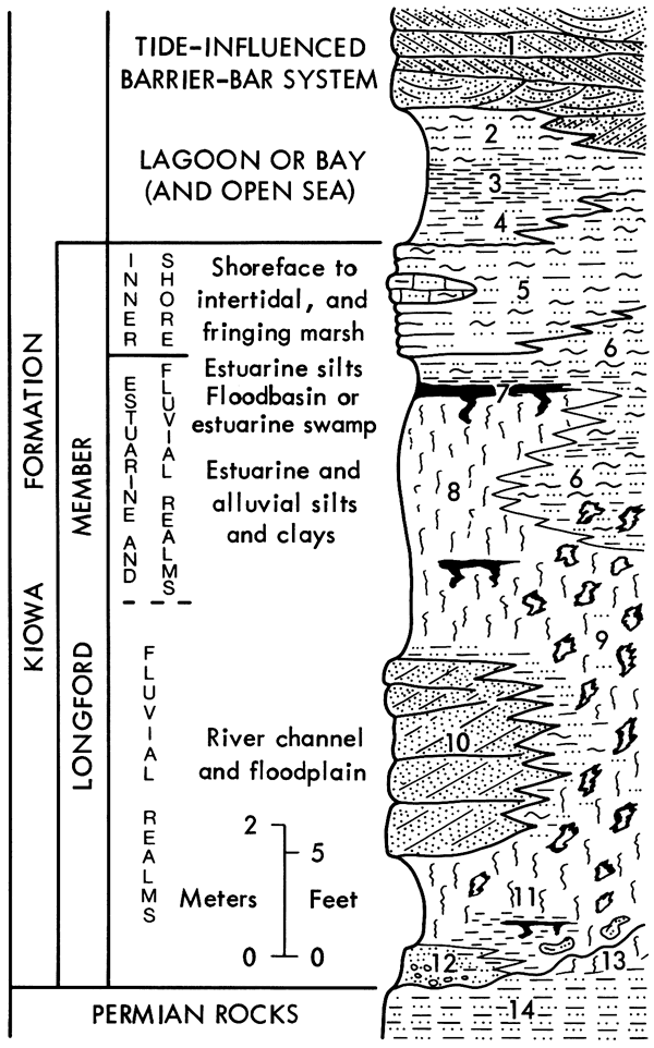
Table 4--Abbreviations used in Figure 15.
| A | abundant | Lt | light | |
| Bk | black | M | medium | |
| Br | brown | MS | mudstone | |
| C | coarse | N | north | |
| Cbn | carbon | Ol | olive | |
| Cbnaceous | carbonaceous | Or | orange | |
| Cbnized | carbonized | R | red | |
| concs | concretions | S | small, south | |
| CS | claystone | SE | southeast | |
| Dk | dark | SH | shale | |
| F | fine | Sp | sparse | |
| fracs | fractures | SS | sandstone | |
| frags | fragments | ST | siltstone | |
| Gn | green | Sty | silty | |
| Gy | gray | SW | southwest | |
| interlam | interlaminated | tab | tabular | |
| L | large | VF | very fine | |
| lam | laminae, laminated | Yw | yellow |
Several lines of evidence indicate that linear clastic shorelines characterized Kiowa sedimentation in north-central Kansas, and that thick, lenticular deposits of Kiowa sandstone (Franks, 1966, 1975) formed barrier systems. Upward coarsening gradations from typical Kiowa shale through sequences of interlaminated shale, siltstone, and sandstone, into the thick, lenticular deposits of sandstone (Fig. 15) accord with the depositional records of barrier bars (Davies and others, 1971). Flaser bedding, transverse ripple marks, interference ripple patterns, and U-shaped burrows within the interlaminated parts of the gradations also are in keeping with the interpretation. One articulated specimen of the mactrid clam Flaventia was found in a conglomeratic lens in one of the thick, lenticular deposits of sandstone (Franks, 1966, 1975). The diverse kinds and orientations of high-angle cross-strata within the thick, lenticular deposits and the presence of seaward-dipping, large-scale, low-angle cross-strata in the upper parts of some of the deposits also support the barrier-bar interpretation. Some of the high-angle cross-strata dip southwestward, parallel to the depositional slope of the Kiowa Formation, but much of the high-angle cross-stratification dips to the south and southeast, parallel to the length of many of the thick, lenticular deposits and parallel to the depositional strike of the Kiowa Formation (Fig. 1). The southward dipping cross-strata probably reflect longshore transport of sand in the shoreface zone. The low-angle cross-strata formed in beach-face sands.
Log-probability plots of grain-size distributions of samples from thick, lenticular deposits of Kiowa sandstone also point to deposition of the sand in barrier systems. The plots also contrast sharply with those from Longford sandstone. Curves A and B, Figure 13, are representative of the log-probability plots of size-analysis data from a large number of samples taken from thick, lenticular deposits of Kiowa sandstone. According to Visher (1969), the curves can be subdivided into nearly straight-line segments that reflect those parts of the grain-size distributions that were deposited as components of suspension, saltation, and traction grain populations. Washing of fines from the sandy sediment also influences segmentation of the curves (Stapor and Tanner, 1975). The fluid-dynamic regimes associated with particular depositional environments are thought to impart characteristic shapes to the grain-size curves despite such factors as source-area controls, inheritance of basic grain populations from pre-existing sediment, and post-depositional changes in the sediment (Visher, 1969; Kolmer, 1973; Stapor and Tanner, 1975). Admittedly, the curves must be evaluated with some care and cannot serve as the only basis for analysis of depositional environments inasmuch as post-depositional growth of interstitial clays and cements can have profound affects on their shapes (Wilson and Pittman, 1977). Nonetheless, Visher's empirical method has been employed with some success and may have greater reliability than other techniques of environmental analysis that depend on grain-size characteristics of sandstone (Siemers, 1976; Amaral and Pryor, 1977).
In curves A and B (Fig. 13), fine-grained saltation populations form steeply sloping, well-sorted, central parts of the distributions between 1.5 and 2.75 φ-units. The saltation populations amount to more than 95 percent of the distributions. Suspension populations are represented by the gently sloping, poorly sorted parts of the curves starting at about 2.75 0-units. Small, medium- to coarse-grained traction populations can be inferred from the segments between 0.5 and 1.5 φ-units.
Environmental interpretations based on the shapes of curves A and B (Fig. 13) are somewhat ambiguous because the curves have attributes of more than one of the nearshore depositional environments examined by Visher (1969), Visher and Howard (1974), and Walton and Goodell (1972). The large, well-sorted saltation populations, combined with the small traction populations truncated near 1.5 φ-units, may indicate that the sand accumulated in dune ridges adjacent to Kiowa beaches (Visher, 1969, p. 1083). On the other hand, the well-defined suspension populations associated with a 2.75 to 3 φ-unit break in slope suggest wave-zone sedimentation (Visher, 1969, p. 1083, 1087; Figs. 7, 9-B), but the curves lack the well-developed, coarse-grained traction populations generally found in sublittoral or shoreface, wave-zone sediments (Visher, 1969; Visher and Howard, 1974; Sanders and Kumar, 1975). Cross-stratification in the sandstone at both sample locales, however, is similar to that in other thick, lenticular deposits of Kiowa sandstone, and it is consistent with longshore transport and sublittoral or shoreface sedimentation of the sand (Franks, 1966, 1975). It includes trough and wedge-planar sets of high-angle cross-strata whose vector resultants are oriented S 35° E (curve A) and S 9° E (curve B), approximately parallel to the depositional strike of the Kiowa Formation (Fig. 1). The absence of large, coarse-grained traction populations in the curves may only mean that nearshore realms in the Kiowa sea generally lacked an abundant supply of coarse sediment (cf. Table 3 and Franks, 1966, 1975).
Evidence of tidal action
Whether or not tides affected Kiowa sedimentation also is important to the interpretation of Longford depositional environments, especially if intertidal sedimentation is invoked to account for parts of the capping siltstone (Fig. 15). The same may be true if estuarine environments are called upon (cf. Pritchard, 1967; Schubel and Pritchard, 1971). The extent to which tides influenced sedimentation in ancient epicontinental seas like the Kiowa sea has been questioned (Shaw, 1964), but tidal effects may have been marked (Ryer, 1976; Swift, 1969, p. DS-7-DS-14), especially in epicontinental seas that had "open connections to the oceans" (Curray, 1964, p. 196). The Early Cretaceous Kiowa sea had broad connections to the oceans in the general region that now forms the Texas Gulf Coast (Williams and Stelck, 1975), and evidence that progradational tidal deposits formed along the western borders of the Kiowa sea has been reported from Colorado (MacKenzie, 1972, 1975; Weimer and Land, 1972). Franks (1975) cited evidence from southwestern Kansas that tides also influenced estuarine deposition of parts of the Cheyenne Sandstone as the Kiowa sea transgressed into that area.
Longford rocks, however, contain little definitive evidence of tidal deposits, even though tides apparently affected the Kiowa sea. The rocks lack upward fining, progradational sequences of tidal deposits such as those that Klein (1971, 1972) proposed as models for estimating ancient tidal ranges. Nor do the rocks show many of the sedimentary features, or sequences of features, described from modern, tide-controlled environments (Ginsburg, 1975; Klein, 1976; Reineck and Singh, 1973; Reineck, 1972; Terwindt, 1971; Van Straaten, 1961; among others). For understandable reasons, studies of modern tidal environments have been concentrated along coasts where the tidal range is at least as great as 1 m, and commonly much greater, and where progradation of supratidal, intertidal, and subtidal deposits is active. Few studies have dealt with the records of tidal sedimentation produced during marine transgression, particularly in regions of small tidal range. Indeed, some studies (Fischer, 1961; Kraft, 1971; Ryer, 1977; Swift, 1968) indicate that records of tidal-flat sedimentation may largely be destroyed during transgression. That abundant evidence of tidal sedimentation should be lacking in Longford rocks, therefore, is not surprising, particularly if rates of supply of sediment did not allow extensive progradation of tidal deposits.
The best evidence that tides influenced Kiowa shorelines, and presumably, therefore, Longford sedimentation, is found in the thick, lenticular deposits of Kiowa sandstone that formed the barrier systems behind which Longford sediments accumulated. Locally, exposures of cross-stratified sandstone show elements of the bedding and grain-size sequences that are produced along barrier coasts by the migration of tidal inlets (Kumar and Sanders, 1974). Indications of tidal-channel, spit-platform, and beach deposits can be recognized. Reactivation surfaces (Klein, 1970) separate sets of cross-strata in places, and the surfaces of scour channels are marked by concentrations of shale pebbles as well as granules of quartz and chert (Franks, 1966, p. 75, 82). Sparse, shallow scour channels are filled by conglomeratic lenses, which, at one locality, contained a single specimen of the mactrid clam Flaventia. In places, scour channels at the bases of thick, lenticular deposits of sandstone are filled mainly by shale-pebble conglomerate, the imbricated pebbles of which were derived by reworking of shale and siltstone underlying the sandstone bodies. All of the above features are consistent with the action of tidal currents along barrier coasts. They imply that tides could well have influenced inner shore sediments of the Longford Member.
Additional evidence that tides influenced nearshore Kiowa sedimentation is seen in the grain-size distribution curves in Figure 14. Both curves are significantly different from curves A and B, Figure 13, even though all of the samples came from thick, lenticular deposits of sandstone. Curve A, Figure 14, is from sandstone in the lower parts of the Kiowa Formation, not far above the contact with the Longford Member. Curve B represents sandstone that is either in the upper parts of the Longford Member or in the lower part of the overlying Kiowa Formation. The sandstone caps an outlier of the Longford Member (sec. 27, T. 8 S., R. 2 E., Clay County, Pl. 1), but the exposures do not allow precise determination of the stratigraphic position of the sandstone. Both curves in Figure 14 are marked by the absence of traction populations, by moderately well sorted saltation populations extending from 0.5 to about 1.75 φ-units, and by well-defined, poorly sorted suspension populations finer than 2.5 or 2.75 φ-units. The suspension populations amount to nearly 10 percent of the samples. The saltation populations are less well sorted than those in curves A and B, Figure 13, but they are better sorted than the saltation populations in curves C and D. In contrast to the curves in Figure 13, the breaks between the suspension and saltation populations are not sharp. Rather, the breaks in Figure 14 consist of straight-line segments extending from about 1.75 to 2.5 or 2.75 0φ-units. The segments may stem from the mixing of fundamentally different grain-size distributions, or from the presence of a population of grains that behaved as part of a saltation population under one set of hydraulic conditions, and as part of a suspension population under higher energy conditions.
Curves A and B, Figure 14, have shapes that accord with deposition in tide-regulated or tide-influenced environments. Especially important are the gently sloping segments between 1.5 to 1.75 and 2.5 to 2.75 φ-units that connect the saltation and suspension populations. Grain-size curves showing such segments have been reported for sands from both modern and ancient tidal channels, tidal flats, tide-controlled estuaries, and tide-regulated marine shelves (Sindowski, 1957; Visher, 1969; Visher and Howard, 1974; Walton and Goodell, 1972). Especially striking is the similarity of curves A and B to some curves from sand waves in the tide-controlled Altamaha River estuary (Visher and Howard, 1974, Fig. 18) and to suites of curves from Bajocian tidal-flat and tidal-channel sediments, as well as some curves from modern tidal-flat sands from the Frisian coast (Sindowski, 1957, p. 257, Fig. 33; p. 259, Figs. 37, 38). Curves A and B also are similar to a curve plotted by Visher and Howard (1974, Fig. 23) to illustrate the effects of fractionation on sediment that might finally be trapped in the troughs of sand waves in the mouth of a tidal inlet. Interestingly, the sandstones represented by the curves in Figure 14 not only are cross-stratified, but vector resultants computed for each locality are oriented about S 40° W, approximately down the depositional slope of the Kiowa Formation, and at a large angle to cross-strata in the shoreface sands described in the preceding section (curves A and B, Fig. 13).
Fluvial and Estuarine Associations
Most sandstone, the red-mottled siltstone, the red-mottled clay rocks, and some brownish-gray and gray clay rocks below the siltstone that marks the top of the Longford Member are products of fluvial sedimentation. Most of the sandstone probably originated as channel deposits in streams that flowed along the gentle valleys eroded into Permian bedrock. The red-mottled siltstone and clay rocks, and many of the brownish-gray clay rocks, formed as overbank deposits of those streams. The lenticular beds of lignite and nearly black claystone low in the member are interpreted as products of deposition in marshy floodbasins, whereas those near the top of the member may have accumulated as either floodbasin or estuarine-marsh deposits. Much of the wavy-laminated to poorly bedded, light-gray siltstone and some of the gray to brownish-gray clay rocks may have formed as estuarine sediments (Fig. 15).
Sandstone
Log-probability plots of grain-size distributions afford evidence that sandstone in the lower part of the Longford Member originated as fluvial deposits. Curves C and D (Fig. 13) contrast sharply with those from Kiowa sandstone that apparently formed as wave-zone or tide-influenced deposits (curves A and B, Fig. 13; Fig. 14). Curves C and D are marked by poorly sorted suspension populations amounting to 10 percent or more of the samples and by better sorted saltation populations coarser than 2.75 φ-units. The shapes of the curves compare well with curves from modern fluvial sands (Visher, 1969, 1972). Southwesterly dipping, wedge-planar and trough cross -stratification in the sandstone outlier in T. 9 S., R. 2 E., Clay County (Pl. 1), is compatible with, but not diagnostic of, fluvial sedimentation. The sandstone does not show the kinds of upward fining sequences that characterize point-bar deposits or deposits formed by braided streams (Allen, 1965a; Harms and Fahnestock, 1965; Smith, 1970; Visher, 1965, 1972). Either the upper parts of point-bar sequences were not preserved, or the sand may have been deposited in the shifting channel of an unbraided, southwesterly flowing stream. Scour-fill contacts at the base of the sandstone and fragments of penecontemporaneously reworked clay rocks and siltstone incorporated in the sandstone are consistent with fluvial sedimentation. Lenses and layers of sandstone intercalated with red-mottled siltstone and clay rocks also suggest fluvial sedimentation (curve D, Fig. 13).
The Longford (?) sandstone that caps the outlier in sec. 27, T. 8 S., R. 2 E., Clay County (Pl. 1), was discussed in the section on evidence of tidal action. The precise stratigraphic position of the sandstone is not known, but it is near the top of the Longford Member or in the lower parts of overlying Kiowa strata. The sand may have accumulated in a tide-regulated part of a Kiowa barrier system, or conceivably in a subtidal channel close to the inner shore of a lagoon or bay, or as shoals near the mouth of an estuary, where ebb-oriented deposits may be common (Tucker, 1973). Whichever idea may be correct, each accords with the grain-size distribution, the southwesterly dipping cross-strata, and the location of the lens near the contact between the Longford Member and overlying parts of the Kiowa Formation. If the sandstone indeed is within the upper parts of the Longford Member, it indicates a complex interplay of estuarine and nearshore facies, not unlike that described along the South Carolina coast by Colquhoun and others (1972). The same is true for lenses of typical Kiowa shale locally enclosed by the Longford Member.
Red-mottled clay rocks and red-mottled siltstone
Red-mottled Longford claystone, mudstone, and siltstone (Pl. 2; Figs. 7, 12, 15) are inferred to be products of overbank sedimentation by the streams that deposited lenticular Longford sands as they flowed southwestward down broad, gentle valleys eroded into Permian bedrock. The red-mottled clay rocks and siltstone, however, lack the well-developed bedding and lamination of many modern overbank deposits (Allen, 1965b, p. 145-155). Instead, they form massive, lenticular bodies and are marked by small-scale slickensided fractures and by microscopic domain and plexoidal fabrics (Figs. 10, 11; Table 2). The lack of small-scale bedding features, the massive character, the slickensided fractures, and the microscopic fabrics can be interpreted in two ways: (1) as products of flocculation and dewatering (Meade, 1964) of overbank sediments (Franks, 1966, 1975), or (2) as products of soil-forming processes. The "clay skins" along the boundaries of detrital quartz grains (Fig. 11) and along fractures in the clay rocks (Fig. 10-C) strongly suggest a pedogenic origin for the fabrics (Brewer, 1964), and soil-forming processes do lead to the development of relatively homogeneous silts and clays from levee, floodplain, and floodbasin sediments (Allen, 1965b; Edelman and Van der Voorde, 1963).
Grain-size distributions provide added insight into the environments of deposition of some of the red-mottled siltstone. Curve E, Figure 13, is from the poorly sorted, coarse-grained, red-mottled siltstone shown in Figure 12. The siltstone encloses layers of fluvial sandstone represented by curve D (Fig. 13), and curve E can also be examined according to the methods of Visher (1969). The curve shows a weakly defined, poorly sorted saltation population that merges with a large, poorly sorted suspension population. The shape of the curve is markedly similar to the shapes of some curves for materials deposited by turbidity currents (Visher, 1969, p. 1100-1103, Figs. 20-B, 20-D). Curve E could well reflect deposition of suspended sediment as levee or other overbank accumulations of the fluvial system that deposited the sands represented by curve D (Allen, 1965b, p. 145). Alternatively, the shape of the curve might be attributed to post-depositional homogenization of overbank sediments by soil-forming processes, and the admixing of sand, silt, and clay from originally better sorted sediments. Either way, the grain-size distribution of the siltstone is compatible with overbank fluvial sedimentation.
The origins of the red, hematitic mottles in Longford clay rocks and siltstone (Figs. 7, 12) also are pertinent to considerations of Longford sedimentary environments. A genetic relationship between the red mottling and the fabrics shown by the clay rocks is suggested by the common concentration of hematite stain and coatings along slickensided and other small-scale fractures in and near the red mottles in the clay rocks (Fig. 10-C). Moreover, the mottles show striking similarity, both in gross aspect and in detail, to so-called soft plinthite or hematitic mottles that abound in a variety of lateritic tropical soils (Soil Survey Staff, 1960, p. 62; Mohr and others, 1972, p. 190). As is true for the fabrics shown by the clay rocks, the red mottles may also stem from soil-forming processes.
Franks (1966, 1975) suggested that the red mottles in Longford and Dakota clay rocks formed by way of early diagenetic, partial reduction and redistribution of iron oxides in sediments that initially were stained red or brown by iron oxides. The presence of reworked clasts of red-mottled claystone and mudstone in Dakota clay-pebble conglomerate (Franks, 1966, p. 211) and the presence of red mottles in subsurface Dakota rocks (Swineford and Williams, 1945) were cited as evidence that the mottles developed only shortly after deposition of the sediments. Evidence for partial reduction and redistribution of iron oxides in both Longford and Dakota rocks includes the light-gray to greenish-gray interareas between the mottles, the local presence of spherulitic siderite in the rocks, and the persistence of flecks of carbonaceous matter and trace amounts of pyrite in the light-gray to greenish-gray parts of some of the mottled rocks. An early diagenetic origin for the red mottles also is consistent with their generation by soil-forming processes operating in unconsolidated alluvial deposits.
Development of the red mottles in Longford clay rocks and siltstone most likely occurred during the initial stages of soil formation in alluvial sediments, during so-called soil ripening (Pons and Zonneveld, 1965), but red mottles also are characteristic of the B zones of groundwater laterites (Mohr and others, 1972). Soil ripening entails dewatering of sediments; oxidation and removal of organic matter; reduction, redistribution, and oxidation of iron compounds under the influence of fluctuating water tables (gley formation); consequent color mottling; and biological and physical homogenization of mineralogically and texturally immature soils before well-developed soil profiles can form. Color mottles are characteristic of gleyed hydromorphic soils developed in alluvial sediments (Buringh, 1970, p. 71; Edelman and Van der Voorde, 1963, p. 259-260), and gleyed soils are common in the floodplains, deltas, and estuaries of modern tropical rivers. One such river, along which mottled alluvial soils are well documented, is the Amazon in Brazil (Sombroek, 1966; Sioli, 1966). A shallow, fluctuating water table in low-lying tropical regions leads to the formation of immature gley soils, whereas groundwater laterites form in somewhat elevated materials where analogous reduction and oxidation of iron compounds are controlled by perched water tables, or by lateral flow of groundwater, to yield so-called pseudo-gley soils (Schlichting, 1973; Kovda, 1973; Mohr and others, 1972, p. 218-219, 229).
The red-mottled clay rocks of the Longford Member, as has been noted, closely resemble red-mottled clay rocks of the Dakota Formation, for which a fluvial origin generally has been accepted (Twenhofel, 1924; Tester, 1931; Plummer and Romary, 1942; Franks, 1975; Siemers, 1976). Thorp and Reed (1949), moreover, suggested that the red-mottled clay rocks of the Dakota Formation are similar to the red-mottled parts of lateritic soils, particularly the mottled zones of ground-water laterites that were described in the Amazon region of Brazil by Marbut (Marbut and Manifold, 1926?; Marbut, 1932?). They also likened "cellular, slaglike 'ironstone'" in the Dakota Formation to laterite duricrusts (the classical hardened laterite of Buchanan, 1807, or the hard plinthite of the Soil Survey Staff, 1960). Franks (1966, p. 163-165; 1975) noted, however, that materials interpreted as laterite duricrusts by Thorp and Reed were not products of penecontemporaneous lateritic weathering of Dakota sediments. Rather, geologically young (Pleistocene or Holocene) weathering of surface exposures of Dakota clay-pebble conglomerate and sandstone gave rise to the cellular and irregular, concretionary iron-oxide structures. Even so, Thorp and Reed (1949) may have been closer to the mark than Franks (1966, 1975) allowed inasmuch as soil-forming processes can account for the development of red-mottled Dakota and Longford rocks, and it might be tempting to assign a groundwater laterite origin to the red-mottled clay rocks and siltstone of the Longford Member.
The red mottles in Longford rocks do show a marked resemblance to mottled soft plinthite that characterizes the B horizons of groundwater laterites and other latosols of tropical regions (Mohr and others, 1972, Pt. 11, Chpt. 1). Important differences, however, seemingly exist between red-mottled Longford rocks and groundwater laterites, including those developed in the unconsolidated Tertiary and Quaternary terrace deposits along the Amazon River valley (Sombroek, 1966).
- Longford clay rocks lack vertical changes in color and texture that correspond to the A, B, and C horizons of groundwater laterites (Mohr and others, 1972, p. 198-232; Sombroek, 1966, p. 100-111). Particularly important is the absence from the Longford Member of layers of concretionary, hard plinthite in the upper parts of red-mottled clay sections and the absence of pallid zones beneath the red-mottled rocks.
- The clay-mineral assemblages in red-mottled Longford rocks are less mature than those in ground-water laterites, although both are kaolinitic. Even though ground-water laterite profiles developed in the terrace deposits along the Amazon River are not as intensely weathered as most of the laterite profiles described by Mohr and others (1972), their clay fractions contain no illite, smectite, chlorite, or other 2:1 clay minerals, and they do contain gibbsite (Sombroek, 1966, p. 109). In contrast, neither red-mottled Longford rocks nor soils developed on the modern floodplain of the Amazon River (Sombroek, 1966, p. 155-157) contain gibbsite, whereas they do contain 2:1 clay minerals. Indeed, although red-mottled Longford rocks tend to be more kaolinitic than other Longford clay rocks (Pl. 2), they commonly do contain as much illite, smectite, and chlorite or vermiculite as the unmottled rocks.
- Red-mottled Longford rocks probably formed in low-lying floodplains, whereas the terrains in which ground-water laterites form must have some relief, even if the soils are imperfectly drained (Mohr and others, 1972; Sivarajasingham and others, 1962; Sombroek, 1966).
Fluctuating ground-water tables, whether perched or not, seem to be essential to the generation of ground-water laterite profiles, and the range of fluctuation of water tables in Longford sediments most likely was insufficient to permit the required degree of weathering. Because Longford fluvial sediments accumulated as the Kiowa sea transgressed central Kansas, they probably were not raised appreciably above the general level of the main streams. No doubt, they were water logged much of the time, and were buried by new sediment before extensive weathering could take place. Whether or not the original coloration of the mottles was red, brown, or some shade of orange is problematic, but aging of hydrated iron oxides to hematite (Fischer and Schwertmann, 1975; Van Houten, 1968) could account for their present-day redness. The properties and occurrence of red-mottled Longford clay rocks and siltstone compare most favorably with their generation as gleyed alluvial soils and products of soil ripening, rather than as products of relatively intense weathering and the formation of groundwater laterites.
Lignite and dark claystone
Lenses and seams of lignite and nearly black, highly plastic claystone commonly are underlain by gray clay rocks in which carbonized rootlets are preserved (cf. top of unit 4, measured section 3, Appendix B and Pl. 2; Fig. 5). Such rocks occur both high and low in the Longford Member. Lignite and dark, plastic claystone in the lower parts of the member are judged to represent floodbasin deposits of Longford fluvial systems. Floodbasin sediments commonly are penetrated by abundant rootlets; may contain abundant, transported plant debris and other organic matter; and may be marked by homogenized soils rich in organic matter (Allen, 1965a, p. 152; Edelman and Van der Voorde, 1963, p. 261). The fragmental, abraded nature of the carbonized woody debris in Longford lignite, together with the wavy bedding shown by carbonaceous films and the silty to clayey matrix, indicates that the rock is of detrital origin. Rootlets preserved in underlying gray and carbonaceous clay rocks accord with deposition of the plant debris in low-lying floodbasins of streams. The detrital lignites and associated gray clay rocks near the top of the member, however, could represent deposits that accumulated in the marshy regions of estuaries (Gorsline, 1967). The detrital character of the lignite could stem from storms that drove woody debris into low-lying terrains along the shores of estuaries, or, more likely, the plant debris could have accumulated as flood deposits on delta plains that formed at the heads of estuaries where streams entered the drowned parts of their valleys.
Dark, nearly black, plastic, kaolinitic and smectitic claystone, into which some of the lignite beds grade laterally, shows abundant slickensided fractures, churned fabrics, and downward projections of the dark clay into underlying gray clay rocks. The fractures, churned fabrics, and projections are features that are characteristic of so-called vertisols (Soil Survey Staff, 1960, p. 124). Vertisols develop deep cracks during dry spells. Surface material sloughs into the cracks and becomes thoroughly churned into the soil during repeated wetting and drying. Although vertisols are not necessarily characteristic of tropical alluvial settings, they do develop in them (Buringh, 1970, p. 74-75, 79-87; Mohr and others, 1972, p. 308-339), and would form in floodbasins where smectite-bearing clays rich in organic matter underwent surface drying between floods while the subsoil remained wet. Such soils also develop in marshy estuarine settings that are subjected to periods of wetting and drying.
Other clay rocks and siltstone
The abundant gray and brownish-gray clay rocks in the Longford Member probably are products of sedimentation in a variety of environmental settings. Many of them contain appreciable carbonaceous matter and some are marked by sparse reddish-brown mottles. Many of them also show slickensided fractures and lack obvious signs of bedding. Such clay rocks, like the more intensely mottled rocks, probably represent floodbasin or other overbank deposits of streams. Others that lack color mottling and obvious signs of internal bedding may represent either stream deposits or sediments that accumulated in estuarine bays. Those that show good lamination and are intercalated with light-gray siltstone near the top of the member most likely stem from deposition on or near estuarine bay-head deltas. The scarce, local lenses or tongues of typical Kiowa shale enclosed within the siltier parts of the member in parts of Saline, Clay, and Ottawa counties may indicate either marine incursions or temporary shifts of lagoonal realms into more estuarine settings during transgression of the Kiowa sea.
Like the associated clay rocks, siltstone near the top of the Longford Member, but below the capping siltstone, probably stems from deposition of silty sediment in different environmental settings (units 12 through 16, measured section 1; unit 1, measured section 2; unit 5, measured section 3, Pl. 2). Some of the silt probably was deposited as overbank stream sediments, but much of it is inferred to have deposited in estuarine realms (unit 6, Fig. 15). Inference of estuarine depositional environments is based on a variety of considerations: (1) on the knowledge that, the Kiowa sea transgressed a mature erosion surface developed on Permian bedrock, and the likelihood that drowned valleys influenced by tides developed during the transgression; (2) on the fact that modern estuaries are traps for abundant silty sediment (Folger, 1972a, 1972b; Gorsline, 1967); and (3) on the stratigraphic position of the siltstone between fluvial sediments below and shoreline to open-sea sediments above (Tucker, 1973). Many of the siltstone beds and lenses show features that are consistent with estuarine sedimentation (Emery and others, 1957; Gorsline, 1967; Terwindt, 1971): locally, bedding surfaces show transverse ripple marks indicative of wave action; in places, ripple laminae, flaser bedding, and low-angle cross-strata are common; much of the siltstone is well sorted and nearly free of admixed clay; and carbonized plant debris and imprints of plant debris are common on bedding surfaces.
Where, within Longford estuarine systems, the silt was deposited is problematic inasmuch as the abundance and distribution of silty sediments in modern estuaries depends on a variety of factors: circulation patterns within the estuary, rates of supply and kinds of river-borne sediments, the extent to which sediment is transported into the estuary from the open sea, and tidal ranges within and without the estuary (Folger, 1972a, 1972b; Gorsline, 1967; Ryan and Goodell, 1972). Stratigraphic proximity of some of the siltstone beds to underlying fluvial deposits suggests that some Longford silt accumulated on or near deltas at the heads of estuaries, perhaps in a fashion analogous to silt near the head of Mobile Bay, Alabama (Ryan and Goodell, 1972, Fig. 17). Some of the coarse-grained silt that contains little interstitial clay, however, may have been deposited near estuary shores. Widespread, upward gradation of the silty rocks into the siltstone that caps the Longford Member seemingly marks a change from estuarine to lagoon or bay sedimentation, and a change from sedimentation dominated by fluvial processes to sedimentation dominated by coastal processes (Fig. 15).
Inner Shore Environments
The widespread, well-sorted, coarse-grained siltstone that marks the top of the Longford Member (unit 5, Fig. 15) shows a number of features that indicate deposition of the silt along the landward, inner shores of an embayed or lagoonal coast that developed behind protective barriers formed by thick, lenticular deposits of Kiowa sand. Chief among those features is the consistent stratigraphic position of the siltstone above highly varied lower Longford rocks and below Kiowa shale and thick, lenticular deposits of Kiowa sandstone (Pl. 2, Fig. 15). The presence of siltstone rather than sandstone in that stratigraphic position emphasizes that the depositional environment was one of low energy compared to the barrier system in which facies-equivalent, lenticular deposits of Kiowa sand accumulated. The good sorting of the siltstone, compared to most other Longford rocks and to the silty and clayey rocks that mark the base of the overlying Kiowa section (measured sections 2 and 3, Appendix B and Pl. 2), certainly accords with deposition of the silt along the inner shores of lagoon or bay systems. Even though fetch and tidal range were limited, wave action and currents were strong enough or persistent enough to bring about effective washing of clays from the silty sediment (Emery and others, 1957; Folger, 1972a, 1972b; Kraft, 1971; Koefeld and Gorsline, 1963; Nichols, 1964; Ryan and Goodell, 1972; Shepard and Moore, 1960). The common presence of transverse ripple marks and interference patterns on bedding surfaces shows that wave action influenced deposition of much of the silt, perhaps in shoreface or subtidal zones of that inner shore. The preservation of scattered low-angle cross-strata is suggestive of local swash-zone or beach-face sedimentation for some of the silt (Reineck and Singh, 1973, p. 301-304; Van Straaten, 1959, p. 204), although the low-angle cross-strata could stem from other causes. Small-scale cross-stratification produced by the migration of current ripples shows that weak currents also operated in the depositional system. In combination with asymmetric, transverse ripple marks and flaser bedding, the current structures imply deposition of some of the silt in tide-influenced, inner shore settings (Reineck, 1972; Reineck and Singh, 1973; Reineck and Wunderlich, 1968; Van Straaten, 1959).
Plants contribute appreciably to the sediments of tidal flats and marshes that fringe many bays and lagoons (Phleger, 1969). The carbonaceous matter and imprints of plant debris in the siltstone at the top of the Longford Member also accord, therefore, with deposition of some of the silt in intertidal to supratidal zones, even though the sediments are not as clayey as those of many modern tidal flats and salt marshes (Reineck and Singh, 1973). Repeated gentle wave agitation, however, can and does remove much clay from intertidal sediments at some locales (Van Straaten, 1961). The reed fossils preserved locally in the lower and middle parts of the capping siltstone are especially suggestive of intertidal or supratidal sedimentation. Likewise, the branching plant stems and rootlets that occur locally near the base of the siltstone impart textures that resemble those of modern, silty to sandy tidal and salt-marsh deposits studied by Bouma (1963). The presence of probable insect burrows and trails (Siemers, 1976, written communication) near the base of the siltstone certainly implies subaerial exposure of some of the silt during part of its depositional history.
The idea of tidal-flat sedimentation for part of the Longford cap siltstone might be even more convincing were there clear evidence of scour-and-fill structures produced by tidal creeks and by tidal channels in lower tidal-flat realms (Van Straaten, 1952, 1961). The size and abundance of tidal creeks, and presumably channels in lower tidal-flat realms, depend, however, on both tidal range and the breadth of tidal flats and marshes (Van Straaten, 1959, p. 198), as well as on the particle size (and permeability?) of the tidal flat sediment (Evans, 1965). In regions of low tidal amplitude where tidal flats and marshes are narrow, few, if any, tidal creeks and channels are apt to form.
The relative scarcity of burrows in the siltstone, especially in the lower parts of the unit, and the absence of macroinvertebrate fossils might also be disconcerting. Scarcity of burrows, however, is not unusual in intertidal deposits where frequent agitation of the sediment takes place (Van Straaten, 1959, p. 199-200). The absence of shelled fossils may reflect the generally brackish character of Kiowa sedimentary environments and the northeastward decrease in salinity detected by Scott (1970a, 1970b). Lagoons and bays bordering the Kiowa sea may well have been too brackish to support extensive populations of shelled invertebrates, and any shell material washed onto or indigenous to tidal flats may have been destroyed by post-depositional dissolution.
The gross sequence of sedimentary structures, trace fossils, and plant fossils that can be established in the siltstone from place to place is compatible with gradual submergence of inner shore deposits of lagoons or bays. Deposition of horizontally stratified to wavy-laminated, largely supratidal silts locally containing abundant plant debris, rootlets, reeds, and insect trails apparently gave way to deposition of intertidal sediments. The intertidal silts show both even stratification and current ripples and locally contain reed fossils, as well as low-angle cross-strata. The intertidal realm was succeeded by deposition of shoreface or subtidal silts showing transverse ripple marks and small-scale cross-strata and locally containing abundant rod-shaped burrows. The inner shore succession in turn is overlain by deposits that probably accumulated in deeper parts of lagoons or bays.
Lagoon or Bay to Open-sea Realms
Dominantly light-gray, silty to clayey shale (unit 3, measured section 2; units 7, 8, 9, measured section 3; Appendix B and Pl. 2) overlies the siltstone that marks the top of the Longford Member and is in sharply gradational contact with the siltstone. The shaly beds mark the base of the overlying parts of the Kiowa Formation. They are inferred to be products of lagoon or bay sedimentation that took place behind barriers represented by thick, lenticular deposits of Kiowa sandstone (unit 4, Fig. 15). The inference is based largely on the stratigraphic position of the beds between the capping siltstone below and characteristic Kiowa shale or thick, lenticular deposits of sandstone above. Pyritic nodules, together with "limonite" stain and gypsum aggregates produced by recent oxidation and weathering of iron sulfide, indicate that reducing conditions prevailed within the sediment. The lamination of the shaly beds does not accord with the churned and homogenized nature of lagoon or bay deposits in areas of abundant benthic life (Shepherd and Moore, 1960), but it does accord with the stratification in lagoon or bay deposits formed where benthic organisms are scarce owing to low salinity or other factors (Van Straaten, 1959). As was noted in the discussion of Longford inner shore deposits, the salinity of the Kiowa sea decreased northeastward. The water in Kiowa bays or lagoons may well have been brackish or nearly fresh and may account for the absence of shelled invertebrate fossils from the rocks.
Appreciable thicknesses of light-gray to medium-gray, silty, poorly fissile shale also occur near the base of the Kiowa Formation along the western fringes of the Longford outcrop belt in parts of Ottawa, Saline, and McPherson counties. These beds, which locally overlie or enclose brownish-gray clay rocks and shale containing appreciable carbonaceous matter, may be facies equivalents of Longford rocks. They may represent lagoon or bay deposits that formed behind Kiowa barrier bars as fluvial and estuarine Longford sediments accumulated to the north and east.
Typical, olive-gray to drab Kiowa shale overlies the light-gray shaly beds above the Longford cap siltstone in many places (unit 4, measured section 2; unit 10, measured section 3; Appendix B and Pl. 2). At least locally, typical Kiowa shale intervenes between the light-gray shaly beds and thick, lenticular deposits of Kiowa sandstone. Typical Kiowa shale is thought to represent open-sea or open-sound sediments. The shale might represent deposits that formed in the central parts of lagoons or bays, but its similarity, both physical and mineralogical, to the bulk of the shale in the Kiowa Formation suggests that the muds were deposited under conditions of more open circulation than those that might have obtained in restricted bays or lagoons (Franks, 1966, 1975; Scott, 1970a, 1970b). That the shale overlies lagoon or bay deposits and locally underlies sandstone that represents parts of barrier systems implies at least local complex shifting of shorelines and incursion of the sea into marginal-marine realms. Both the shale and the thick, lenticular deposits of Kiowa sandstone above the Longford Member indicate continued northeastward transgression of the Kiowa sea.
Prev Page--Description || Next Page--Mechanisms, Provenance
Kansas Geological Survey, Geology
Placed on web March 10, 2009; originally published November, 1979.
Comments to webadmin@kgs.ku.edu
The URL for this page is http://www.kgs.ku.edu/Publications/Bulletins/219/04_envi.html