Kansas Geological Survey, Bulletin 211, Part 2, originally published in 1976
Originally published in 1977 as Kansas Geological Survey Bulletin 211, Part 2. This is, in general, the original text as published. The information has not been updated. The publications is also available as an Acrobat PDF file (8.5 MB).
Cheyenne Bottoms, in east-central Barton County, Kansas, is a basin-like feature, elliptical in shape, the origin of which has not been satisfactorily explained. Several hypotheses have been presented to explain the origin of the feature. Haworth (1897) was the first to write on the origin of Cheyenne Bottoms and attributed the feature to stream erosion. Johnson (1901) advanced the theory that Cheyenne Bottoms was a basin of subsidence caused by removal of soluble masses of salt within the underlying rock. He noted that the gap in the rock wall on the southeast side of the basin did not favor this theory of origin. Bass (1926) prepared a map of salt thickness in western Kansas that shows thinning of the salt beds beneath Cheyenne Bottoms. He (Bass, 1926) believed that this tended to confirm Johnson's theory of salt solution as the cause of the basin-like feature. Latta (1950) indicated that salt solution and subsidence may have been in part responsible for the feature, but also indicated that stream erosion during the Pleistocene played an important part in its origin and present configuration.
This study was begun after the author had been involved in other studies of the salt beds in central Kansas and was in part prompted by the differences of opinion of previous authors as to the origin of the feature.
Cheyenne Bottoms is located near the center of Kansas in east-central Barton County. The basin-like feature occupies an area of about 64 square miles lying principally in Township 18 South and Ranges 12 and 13 West. The area of study includes Townships 17, 18, and 19 South and Ranges 11, 12, 13, and 14 West or an area of about 432 square miles (Plate 1, available as an Adobe Acrobat file).
Cheyenne Bottoms is a relatively flat, featureless basin. On the north, west, and south sides the basin walls are Cretaceous rocks which rise to an elevation above the basin floor of more than 100 feet in a distance of about one mile. On the northeast side, sand dunes rise to an elevation of about 100 feet above the basin floor. The east and southeast sides of the basin are comprised of alluvial deposits which rise 30 to 40 feet above the floor of the basin.
Blood Creek in the northwest and Deception Creek on the north are the two principal streams draining into the basin. These two streams have no discernible channels one-half to two miles after they enter the basin. Numerous small draws enter and spill onto the basin floor with no discernible channels. Surface drainage from the basin is through Cheyenne Creek on the southeast side of the basin. Some water leaves the basin by subsurface movement through the alluvial deposits on the east and southeast sides of the basin.
At the beginning of Paleozoic time, the Precambrian surface in this general area consisted of numerous more or less isolated hills projecting several hundred feet above a relatively flat lowland (Walters, 1946). Throughout much of Paleozoic time, this area was alternately submerged and elevated. During periods of submergence, marine sediments accumulated only to be partly or entirely eroded during subsequent periods when the area was above sea level. Early Paleozoic deposits consisted chiefly of marine limestone, shale, and sandstone. Prior to deposition of Mississippian sediments, upward warping of the pre-Mississippian sediments occurred along a northwest-southeast axis. This pre-Mississippian anticlinal structure has been called the Ellis Arch to differentiate this period of structural movement from later occurrences in this same area. Erosion which followed the elevation of the Ellis Arch truncated the earlier Paleozoic rocks and locally removed all of those that may have overlain the Precambrian hills. Following this period of elevation and erosion the sea again invaded the area and limestones and shales of Mississippian age were deposited. In latest Mississippian or early Pennsylvanian time, this area was again elevated and upwarped forming the Central Kansas Uplift. Erosion removed the Mississippian strata from this area. The area probably remained above sea level until Kansas City time since these rocks are the earliest Pennsylvanian strata in contact with the Precambrian on the Precambrian hills and are in contact with Arbuckle rocks in the lowland areas surrounding the Precambrian hills.
Following the post-Mississippian erosional period, the area was again submerged and remained submerged except for short periods until the latter part of early Permian time when the continental "red beds" were deposited. The area remained above sea level throughout the Triassic, Jurassic, and earliest Cretaceous time. Several hundred feet of Permian "red beds" were eroded during this period. During the latter part of the Early Cretaceous time, the Cheyenne Sandstone was deposited marginal to the advancing Cretaceous sea. This was followed by deposition of the marine Kiowa Formation which was followed by deposition of the Dakota Formation along the margins of the Cretaceous sea as it withdrew from the area. At the beginning of Late Cretaceous time, the area was again submerged beneath a shallow sea and many hundreds of feet of shale, limestone, chalky shale and chalky limestone were deposited. At the end of Cretaceous time, the sea again withdrew; the area has remained above sea level to the present.
During most of the Tertiary Period, the surface was subject to erosion and several hundred feet of Late Cretaceous rocks were eroded. Deposition of sediments of the Ogallala Formation occurred during the Pliocene epoch of the Tertiary. These deposits were thin in this area and have been largely removed by erosion during Pleistocene time. Much of the present topography of this area is the result of erosion which occurred in Tertiary time and erosion and deposition which occurred during the Pleistocene.
The Pleistocene history of this area is complex and interpretation is difficult. In early Pleistocene time the Arkansas River, which presently flows along the south edge of this study area, is believed to have flowed southeastward and eastward through south-central Kansas. The river has migrated northward through lateral shifting and stream captures and is now established in the "great bend" between Ford County, Great Bend, and Hutchinson. During early Pleistocene time, an ancient stream rising in eastern Barton County and following the general course of the present Cow Creek in Barton and Rice counties joined the ancestral Arkansas River in Reno County. This stream, called "Chase Channel" (Fent, 1950), did not directly drain Cheyenne Bottoms, but another stream draining northwestern Barton County and probably the upper Smoky Hill River (Bayne and Fent, 1963) flowed through Blood Creek and Cheyenne Bottoms and joined "Chase Channel" in Rice County near cen. sec. 9, T. 19 S., R. 10 W. Upper Smoky Hill River drainage was captured in early middle Pleistocene time, diverting drainage from the Blood Creek-Cheyenne Bottoms channel into the present Smoky Hill drainage. The present drainage area of that portion of the Smoky Hill River which was diverted from its flow through Cheyenne Bottoms is about 6500 square miles. The smaller volume of water flowing through the Blood Creek-Cheyenne Bottoms Channel caused the channel cutting phase to end and this channel and "Chase Channel" filled, the streams topped their banks and meandered over the area east and southeast of Cheyenne Bottoms. Cheyenne Bottoms was filled with fine-grained materials, probably at the same time the sand dunes east of the bottoms began to form.
The present distribution of the rock units exposed in the study area is a result of the events described in the preceding paragraphs. This distribution is shown on the areal geologic map (Plate 1, a PDF file). The most conspicuous feature shown on Plate 1 is the oval shape of Cheyenne Bottoms. Cretaceous rocks form the valley walls on the north, west, and south sides of the basin and alluvial deposits and sand dunes occur on the east and southeast sides. The Dakota Formation forms the lower basin walls in most of the area in which bedrock forms the basin walls; however, in sections 33 and 34, T. 17 S., R. 12 W. in a structurally low area, the Greenhorn Limestone forms the lower valley wall. On the south side of the basin, the low terraces or flood plains of Walnut Creek and the Arkansas River extend northward to within about two miles of the basin. A bedrock divide separates the two features.
Data on the subsurface geology and structure of the study area were obtained from test holes drilled by Latta (1950) and from gamma logs in the files of the Kansas Geological Survey. Additional information was obtained from publications which are cited in the appropriate places in the text.
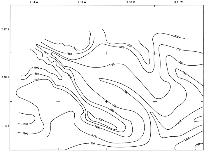
The test hole logs listed in Latta (1950) generally did not penetrate the bedrock more than a few feet and could not be used to determine the deeper structure of the area; however, they were used to construct the map showing the configuration of the bedrock surface (Fig. 1). Figure 1 shows the well-defined early Pleistocene Blood Creek-Cheyenne Bottoms erosional channel and the upper reaches of "Chase Channel." The basin walls rise abruptly on the north, west, and south sides. A bedrock ridge extends southward beneath the sand dunes on the east side of the basin. The Blood Creek-Cheyenne Bottoms channel slopes toward the southeast at about 7 feet per mile to a point just north of Ellinwood where it turns northeast. A bedrock high in the southeast corner of the study area probably caused this deflection. A bedrock channel beginning about midway between Great Bend and Ellinwood and just south of the mapped area trends southeastward at about the same elevation as the Blood Creek-Cheyenne Bottoms channel; however, this channel is believed to be associated with the channel cutting phase of the Arkansas River and is believed to have been cut much later than the Blood Creek-Cheyenne Bottoms channel.
Figure 1--Configuration of bedrock surface.
Using gamma ray logs of about 230 oil and gas wells drilled in the area, structure contour maps were prepared on the top of the Stone Corral Formation, the top of the Hutchinson Salt Member of the Wellington Formation, the base of the Hutchinson salt, the base of the Winfield Limestone, and the top of the Heebner Shale Member of the Oread Limestone. The Precambrian map was constructed from data contained in a publication on Precambrian wells in Kansas by Cole and Ebanks (1974).
Figure 2 shows contours on the top of the Stone Corral Formation. The general dip of the strata in this area is from southeast to northwest. The average dip is about 9 feet per mile. A basin with 20 feet of closure occurs in the western part of T. 18 S., R. 12 W. In the eastern part of T. 18 S., R. 13 W., almost in the exact center of Cheyenne Bottoms just to the west of the closed basin, a north-northeast, south-southwest trending anticlinal fold is present. In T. 19 S., Rs. 13 and 14 W. a rather sharp synclinal fold is present.
Figure 2--Contours showing structure at the top of the Stone Corral Formation.
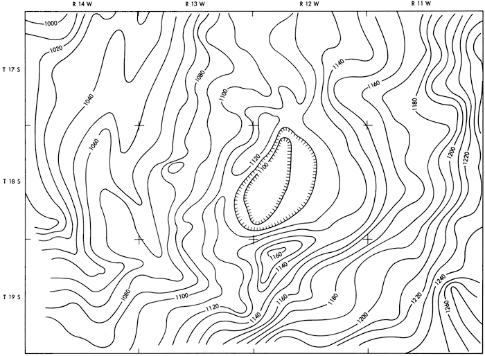
Figure 3 shows contours on top of the Hutchinson Salt Member of the Wellington Formation. This surface generally slopes from east to west at an average rate of 9 feet per mile. The same general features apparent on the Stone Corral structure map (Fig. 2) are present in this map. The closed basin indicated on Figure 3 is somewhat larger in area than that shown on Figure 2 and the anticlinal structure at the west side of the basin is less pronounced on the top of the salt map. The synclinal area in T. 19 S., Rs. 13-14 W. is a prominent feature on this map and Figure 2, as is the dome-like feature in the northwest part of T. 19 S., R. 12 W. Data in the Cheyenne Bottoms area is limited and the addition or elimination of data from one or two wells in this area could change the shape and extent of these features.
Figure 3--Contours showing structure at the top of the Hutchinson Salt Member of the Wellington Formation.
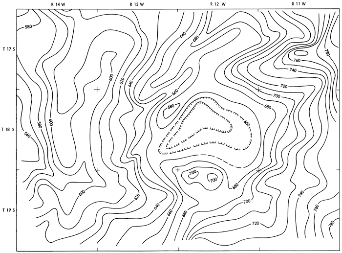
Figure 4 shows contours on the base of the Hutchinson Salt. At or near its base, the Hutchinson salt is interbedded with anhydrite and shale. The change from salt to anhydrite or shale was abrupt on many of the logs and change in lithologies could be clearly interpreted. On other logs, the interbedding occupied a larger interval and a change from salt to other lithologies could not be easily seen. Logs on which the base of the salt could not be clearly defined were not used in preparing Figure 4.
The same general features shown on the Stone Corral and the top of the salt maps are apparent on the base of the salt map. The synclinal area in T. 19 S., Rs. 13-14 W. is more pronounced. The small anticlinal structure just west of the basin-like feature at the center of the Cheyenne Bottoms is present but is larger and west of its usual location.
Figure 4--Contours showing structure at the top of the Hutchinson Salt Member of the Wellington Formation.
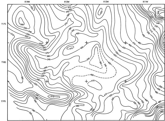
Figure 5 shows contours drawn at the base of the Winfield Limestone. The same features shown on the map of the base of the salt are apparent on this map. The basin-like area in the central part of the Cheyenne Bottoms is somewhat larger than on the map of the base of the salt and the anticlinal structure is apparent west of the basin area. The small dome-like structure in the NW part of T. 19 S., R. 12 W. is no longer apparent.
Figure 5--Contours at the base of the Winfield Limestone.
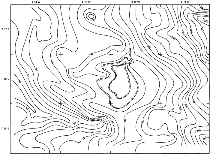
Figure 6 shows contours representing the top of the Heebner Shale. The same general features apparent on the contour maps of the younger beds are again present. The synclinal area in T. 19 S., Rs. 13-14 W. is more pronounced and shows closure in a part of the structure. A closed basin-like feature is present in the southeast part of T. 17 S., R. 14 W. On Figures 4 and 5, this basin was shown as a low synclinal area. This and other closed basin-like features on the map might prove to be synclinal areas rather than basins if additional data were available.
Figure 6--Contours at the top of the Heebner Shale Member of the Oread Limestone.
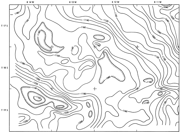
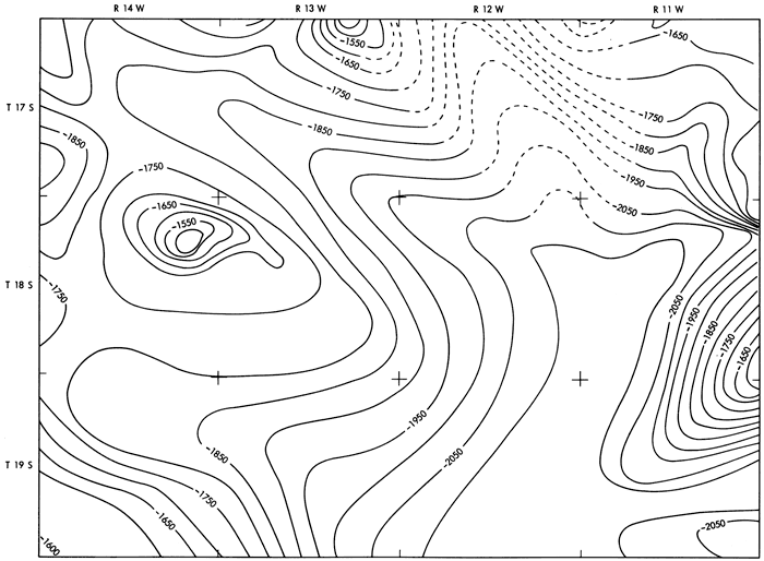
Figure 7 shows contours drawn on the Precambrian surface. Within the study area only a relatively few wells reach the Precambrian and within Cheyenne Bottoms proper only 3 wells reach the Precambrian. For this reason additional townships on the north and east sides of the study area were included in preparing Figure 7 (although they are not shown here). Although data within the area of Cheyenne Bottoms are sparse, the data to the north and east indicate that a low or synclinal area underlies the Cheyenne Bottoms area. The high areas on the east and north sides of the Cheyenne Bottoms have been called Precambrian hills by Walters (1946). Walters considers them erosional features capped by resistant quartzite. The "hills," in many instances, are directly overlain by rocks of Pennsylvanian age while in the low areas Arbuckle rocks of Cambrian and Ordovician age occur.
Figure 7--Contours on the Precambrian Surface.
It is apparent from Figures 4 through 6 that structural features found at shallow depths are also present at greater depths.
When only the map showing structure at the top of the Stone Corral (Fig. 2) and the map showing contours on top of the Hutchinson salt (Fig. 3) are considered, the origin of the Cheyenne Bottoms can be attributed to either solution and collapse or to structural movement. The only evaporite sequence thick enough to support the amount of solution necessary to cause the Cheyenne Bottoms is the Hutchinson salt member of the Wellington Formation. If solution and collapse were the cause of the Cheyenne Bottoms, beds below the Hutchinson salt would not be affected; however, Figures 4, 5, and 6 indicate movement in the beds below the Hutchinson salt. Because the feature is apparent in the deeper rocks, the cause of the Cheyenne Bottoms can only be attributed to structural movement. Rocks at least to the Heebner Shale are affected and although data on the Precambrian surface are quite limited within the Cheyenne Bottoms, the contour map on the Precambrian surface (Fig. 7) shows that the Cheyenne Bottoms overlies a structurally low area on the Precambrian surface. Additional data would probably show close correlation of structural features on the Precambrian with structural features in the rocks higher in the geologic section.
The structure maps, Figures 2 through 7, show that structural movement was the cause of the Cheyenne Bottoms. Using these maps and Plate 1 and Figure 1, an approximate time of the structural movement may be estimated. The time of structural movement could not have occurred before the deposition of the youngest rock unit affected by the structural movement. The map showing structure at the top of the Stone Corral Formation (Fig. 2) indicates movement. Therefore, the movement occurred after deposition of the Stone Corral. The areal geology map (Plate 1) indicates a low or synclinal area adjacent to the northeastern part of Cheyenne Bottoms. In this area, Greenhorn Limestone is found at the level of the flat basin floor of Cheyenne Bottoms. On either side of this area and on the west and south sides of Cheyenne Bottoms, the Dakota Formation is at the level of the basin floor. This map places the structural movement as occurring after deposition of the Greenhorn. The map showing contours on the bedrock surface (Fig. 1) indicates that the basin-like feature was present in the bedrock but the feature has been modified by subsequent erosion which occurred in early Pleistocene time. Since the channel cutting postdates the structural feature, the structural movement occurred before early Pleistocene time and, as shown earlier, after deposition of the Greenhorn Limestone.
This places the structural movement between early Late Cretaceous time and latest Pliocene time. It was during this period of time that other events occurred which affected the Paleozoic and younger rocks of Kansas. The kimberlites in Riley County and the intrusive rocks in Woodson County were also implaced at this time and it was during the later part of this period that regional tilting occurred in this area. No relation between these separate occurrences is implied other than the time factor.
Bass, N. W., 1926, Geologic investigations in western Kansas: Kansas Geol. Survey, Bull. 11, pp. 1-96. [available online]
Bayne, Charles K., and Fent, O. S., 1963, The Drainage history of the upper Kansas River basin: Kansas Acad. Sci., Trans., v. 66, no. 3, pp. 363-377.
Cole, Virgil B., 1962, Configuration of top of precambrian basement rocks in Kansas: Kansas Geol. Survey, Oil and Gas Inv., No. 26.
Cole, Virgil B., and Ebanks, W. J., Jr., 1974, List of Kansas wells drilled into Precambrian rocks: Kansas Geol. Survey, Subsurface Geol. Series 1, pp. 1-101.
Fent, O. S., 1950, Geology and ground-water resources of Rice County, Kansas: Kansas Geol. Survey, Bull. 85, pp. 1-142. [available online]
Haworth, Erasmus, 1897, Physiography of western Kansas: Kansas Univ. Geol. Survey, vol. 2, pp. 11-49.
Johnson, W. D., 1901, The High Plains and their utilization: U.S. Geol. Survey, 21st Annual Report, pt. 4, pp. 601-741.
Latta, Bruce F., 1950, Geology and ground-water resources of Barton and Stafford Counties, Kansas: Kansas Geol. Survey, Bull. 88, pp. 1-228. [available online]
Walters, Robert F., 1946, Buried Pre-Cambrian hills in northeastern Barton County, central Kansas: Am. Assoc. Petrol. Geol., Bull., v. 30, pp. 660-710.
Kansas Geological Survey, Geology
Placed on web Sept. 12, 2008; originally published in Jan. 1977.
Comments to webadmin@kgs.ku.edu
The URL for this page is http://www.kgs.ku.edu/Publications/Bulletins/211_2/index.html