![]()
Prev Page--Southeastern Kansas || Next Page--Appendix
Conclusions
Stratigraphic Considerations
1. Members--All five members of the Stanton Formation recognized in northeastern Kansas can be traced through the algal-mound facies belt into northern Montgomery County (Fig. 3). The Stoner Limestone Member is the first to disappear southward as its algal-mound development pinches out abruptly into fossiliferous shale at the north margin of the terrigenous detrital facies belt in central T. 32 S. (Fig. 4). The Captain Creek Limestone Member is traced out of the algal-mound facies belt as a thin sponge-rich calcilutite overlying an oolite in T. 33 S., R. 15 E.; it apparently correlates to the Tyro oolite bed which appears in northern T. 34 S. and is traced southward across the Oklahoma border. The South Bend Limestone Member is traced across the entire extent of the detrital facies belt exposed in Montgomery County as a thin but distinctive conglomeratic limy sandstone overlain much of the way by echinoderm- and calcisponge-rich calcilutite. The two shale members south of the Stoner pinchout can no longer be separated at a consistent stratigraphic horizon and so are separated arbitrarily by two beds of limestone and one of quartz siltstone, which lie at slightly different horizons within the Stanton interval. Defined in this way, the Eudora Shale Member thickens southward and consists mainly of shale that includes diversely fossiliferous strata equivalent to the Stoner near the top; the Eudora contains a mollusc-dominated fauna in the middle and lower parts, and a thin fissile black shale at the base. The Rock Lake Shale Member thickens southward into the detrital belt where it contains both great thicknesses of sandstone and thin fossiliferous limy horizons of different degrees of traceability. South of the disappearance of the intervening Bolton bed, the two shale members are inseparable as the Eudora-Rock Lake interval, which constitutes nearly all the Stanton Formation in southernmost Kansas.
2. Beds--One quartz siltstone bed and three thin limestone beds that appear at various positions in the Stanton interval in the detrital facies belt are newly named and described. The Timber Hill bed is a thin quartz siltstone that appears about 1 mile south of, and stratigraphically above, the Stoner pinchout. The Rutland bed, appearing above the south end of the Timber Hill bed, is a dull-orange-weathering, cross-bedded, abraded-grain skeletal calcarenite in which red- and green-algal debris dominates a diverse group of invertebrate fragments and scattered ooids. Southward and apparently stratigraphically, lower, the Bolton bed is a more yellowish-weathering skeletal calcarenitc with less abrasion of grains, very little red or green algae, but with some osagia coatings around the dominant invertebrate debris, and a greater though still subordinate amount of ooids. Appearing below the Bolton bed south of the disappearance of typical Captain Creek, and extending across the Oklahoma border, the Tyro bed is a largely quartz-nucleated oolite with thickly coated ooids and scattered invertebrate fragments.
Dominance of grain types in the three calcarenite beds trends southward from red and green algae nearest the mound belt through invertebrate debris to ooids with quartz nuclei. The Timber Hill, Rutland, and Bolton beds separate the Eudora and Rock Lake Members. The Tyro bed lies at the stratigraphic horizon of the Captain Creek Member and marks the base of the Stanton in the southern two townships in Kansas.
At least two thin limy zones within the Rock Lake Member and Eudora-Rock Lake interval in southern Montgomery County consist largely of oolitic and fossiliferous quartz sandstone typically with thinner oolitic coatings on a smaller proportion of the grains than in the Tyro. Much of the Rock Lake and Eudora-Rock Lake is characterized by two gross sandstone facies, thin-bedded and massive; one massive unit in T. 33 S. and adjacent sections of T. 32 S. seems well enough delineated to be termed the Onion Creek sandstone body.
3. Correlation into Oklahoma--Of all the distinctive traceable units in the Stanton Formation, only the Tyro bed and South Bend Member (and by definition the intervening Eudora-Rock Lake interval) are traced into Oklahoma, where both limestone beds were mapped as the Birch Creek Limestone and thus assumed to be the same horizon by Oakes (1940a) and ultimately by the Geological Map of Oklahoma (1954). Because the major outcrop trend extending northward from type Birch Creek Limestone west of Caney River on Oakes' map joins directly with the South Bend, that portion of the mapped Birch Creek east of Caney River should be removed from the Birch Creek and placed in the Tyro (in T. 29 N., R. 14 E. and eastern R. 13.E.) and probably also into higher limy zones in the Stanton (in western T. 29 N., R. 13 E.). More importantly, the thick sequence of post-"Birch Creek" (= post-Tyro) strata mapped in northern T. 29 N., R. 13 E. belong to the Eudora-Rock Lake interval and should be placed in the Stanton, which is mostly pre-Birch Creek in position. Nevertheless, final establishment of correlation of the South Bend Member of the Stanton to type Birch Creek Limestone should await availability of accurate 7.5-minute quadrangles in Oklahoma for detailed tracing of the horizon.
In the meantime, assuming that the South Bend-Birch Creek correlation is correct, it is suggested that the Wann Formation be redefined to include both the Birch Creek Limestone as a member marking its top and the Torpedo Sandstone as a member within its upper part, instead of picking the upper limit of the Wann at the base of the Torpedo, which probably has been mapped at several different horizons. This allows the Wann to be recognized as the exact Oklahoma equivalent of the Lane, Wyandotte, Bonner Springs, Plattsburg, Vilas, and Stanton Formations, instead of being limited upward at some ill-defined horizon or horizons within or possibly below the Stanton, as it is now. Furthermore, where the Tyro bed is present, it conveniently divides the Wann Formation into two subequal parts: the lower Wann, which is equivalent to the Lane-Vilas Shale, and the upper Wann, which is equivalent to the Stanton Formation.
4. Sedimentary break at Rock Lake-South Bend contact--Occurrence of widespread evidence for regression in the upper Rock Lake, erosion at the contact, and transgression during deposition of the South Bend throughout eastern Kansas marks a significant regional sedimentary break. Attempts should be made to trace the break farther across the Midcontinent Basin. If it has an underlying tectonic cause, the nature of the event it signifies may aid in unraveling the history of mountain-building going on at this time in southern Oklahoma.
The break occurs just below the Missourian-Virgilian boundary as now recognized. If a sedimentary break is considered desirable for a stage boundary, then lowering the boundary to the base of the South Bend would seem appropriate. Such a decision, however, should be left to biostratigraphic investigations. In any case, detailed study of the biotas on either side of the break, particularly of environmentally equivalent biotas in the South Bend and Stoner Limestone Members, is warranted in order to evaluate the time significance of the sedimentary break at the contact.
Depositional Considerations
5. General sequence of environments--In the phylloid-algal mound facies belt of Northern Montgomery County, the sediment surface during deposition of the limestone members was being kept close to sea level by phylloid-algal production of sediment at a rate sufficient to compensate for subsidence of the sea bottom. Only during deposition of shale members did terrigenous detrital influx encroach into this region enough to deposit a few feet of Eudora shale above the Captain Creek mound and a few feet of Rock Lake shale and sandstone, particularly in local lows, above the Stoner mound. Following the regression that closed Rock Lake deposition, the transgression that initiated South Bend deposition stabilized sea level rise at shallow enough depths over the thickest part of the Stoner mound for algal-mound development to continue locally during South Bend deposition.
To the south in the detrital facies belt (Fig. 4), however, too much influx of terrigenous detritus, combined with more subsidence than could be easily compensated by phylloid-algal proliferation, inhibited much growth of phylloid algae. After the detrital influx that dominated earlier deposits lessened, Stanton deposition was initiated in central and southern Montgomery County by local developments of ooids, presumably on small shoals. On the southern shoal, ooids nucleated mainly around quartz sand grains and moved in megaripples southwestward off the shoal, apparently accreting as they moved, to form the Tyro bed. On the northern shoal, ooid formation was succeeded over a broader area by proliferation of calcisponges and other invertebrates in a quiet environment of accumulation of fine detritus that was followed by carbonate mud to form the thin southern end of the Captain Creek Member. Much of this carbonate mud may have been derived from the growing Captain Creek algal mound to the north. While continuing subsidence combined with extremely low detrital influx caused deepening of the sea bottom, an episode of bottom stagnation that affected only deeper water resulted in the thin black shale that marks the base of the Eudora over both the Captain Creek sponge calcilutite and the Tyro oolite. Then fine clastics flooded in again in greater quantities to form most of the Eudora of central Montgomery County. This influx of fine clastics brought about environments of high turbidity and soft substrate like those that had preceded Stanton deposition; they now produced gray shales with a molluscan fauna in the Eudora that is similar to those of the Lane-Vilas Shale, below, and much of the Wann Formation to the south.
While fine clastics dominated the thicker Eudora to the north, greater amounts of quartz sand flooded in over the basal dark shale in the south. This coarser influx advanced northward to the point in northern T. 34 S. where invertebrate growth replaced the previous fine detrital influx on a large enough scale to produce the Bolton bed. Farther northward toward the mound edges, fine clastics flooded in throughout deposition of the Stoner mound and ceased only long enough locally for invertebrate and algal debris from various sources to be swept up into the Rutland bed just after a pulse of coarser detritus left the Timber Hill siltstone bed spread over part of the sea bottom. In the meantime, the continuing flood of quartz sand from the south more strongly inhibited carbonate formation in the southern region throughout the remainder of Stanton deposition. Only at a few times was detrital influx reduced enough in limited areas to allow the oolitic coating of sand grains and growth of conspicuous numbers of shelled organisms (locally encrusted by osagia-like stromatolites), which formed the discontinuous third and fourth limy zones within the Eudora-Rock Lake interval. In higher parts of the sandy sequence, facies resembling channel and interchannel deposits suggest that deltaic complexes became established in this region. One of these advancing fronts of sand entered T. 33 S. at an angle to the present outcrop belt just after the Bolton bed was formed and dominated deposition of the Rock Lake Member in this region as the Onion Creek sandstone body. This body finally advanced northward over the remaining area of fine clastic deposition above the Rutland bed and encroached onto parts of the Stoner mound before a general regression terminated deposition of Rock Lake clastics over much of eastern Kansas.
The ensuing transgression first reworked a variety of eroded and residual materials in a number of micro-environments on the irregular surface to produce the coarse sandy, conglomeratic base of the South Bend. Then deepening of the sea inundated all of the surface, and lime mud was spread uniformly over the sandy conglomerate in the areas that were submerged below wave base. Stanton carbonate deposition was finally ended over the entire outcrop area by the beginning of the immense influx of terrigenous detritus that formed the succeeding Douglas Group.
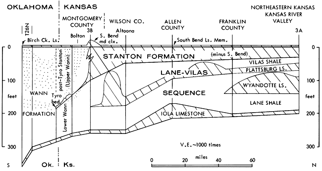
6. Significance of the sequence--Because the phylloid-algal buildups represent nearly continual near-surface water depths, the thickness of the standard section (Fig. 3B) in northern Montgomery County, which they dominate, provides a fair estimate of the net amount of subsidence undergone by the south end of the algal-mound facies belt during Stanton deposition. This amounts to 120 feet for the entire Stanton and 100 feet for the pre-South Bend-Stanton interval, which was terminated by the regression. Thicknesses of the equivalent stratigraphic interval to the south show that greater subsidence was taking place in the detrital facies belt, on the order of 130 to 140 feet around Bolton and in places as much as 160 to nearly 200 feet south of Bolton for the pre-South Bend-Stanton (Fig. 4, 26). Even if 10 or 20 feet is subtracted from detrital belt thicknesses to account for greater elevation than the algal mounds of a possible subaerial delta near the end of Rock Lake deposition in the detrital belt, this would be more than offset by the greater compaction undergone by shales in the detrital belt compared to what is generally observed for lime muds, which dominate the mound belt.
Figure 26--Generalized cross section along strike of upper Missourian units from northeastern Kansas to northern Oklahoma showing complementary thickness relations between Stanton Formation and underlying Lane-Vilas sequence. Datum is base of South Bend Limestone Member and probably correlative Birch Creek Limestone. Dominant lithologies are generalized with limestone lined, sandstone dotted, and shale left blank. Thicknesses averaged from ranges obtained from following sources: Kansas River Valley--Crowley (1969), Moore and Merriam (1965, p. 12-13); Franklin County--Ball and others ( 1963); Allen County--Miller (1969); Wilson County (Altoona)--Wagner ( 1961); Montgomery County--Figure 4 in this paper; northern Oklahoma--Oakes (1940a, p. 76).
The great increase in sand upward through the Stanton interval and progressively northward across the clastic belt represents an expected vertical sequence of fine to coarse detrital filling of a basin from the south. Nevertheless, this was not just a simple overwhelming of the subsiding basin by nonmarine clastics in subaerial environments. The presence of relatively diverse marine fossil assemblages at several horizons in the detrital Stanton interval reflects periodic establishment of subtidal, relatively open marine environments and signifies that sedimentation was not keeping up with subsidence continually in the detrital belt. It is also possible that the water was substantially deeper at times within the detrital facies belt than in the algal-mound facies belt. The molluscan fauna that characterizes both the Wann and Eudora has been considered "geosynclinal," and its particular biotic makeup seems to reflect a turbid-water, soft-substrate environment more than a near-shore regime with fluctuating salinity; thus it would be compatible with relatively deep water. [Note: 7 Presence of osagia-like coatings consisting mainly of encrusting foraminifers and micrite on some fossils at one locality (near NW cor 32-34-15) might argue against very deep water because such coatings supposedly are formed largely by blue-green algae; however, as in osagia coatings in many Kansas limestones, no definite remains of blue-green algae are yet apparent in thin section.] Considering both the possible intermittency and localized nature of rapid detrital influxes, deeper water on the order of several tens of feet could have been established periodically during continual subsidence within the detrital facies belt.
It can be shown that sedimentation caught up with subsidence only if subaerial deltas are definitely identified or if the oolite beds represent the areas in which their component ooids were generated. The shoreline environment suggested by the higher oolitic zones is compatible with the channelling suggested by the associated shale pebbles and by the possible deltaic sandstone facies present in this part of the section. On the other band, the apparently consistent westward to southwestward direction of movement indicated by cross-bedding dips in the Tyro oolite, along with increase in size of the ooids toward the southwest (Hafer Run), suggest the possibility that Tyro ooids were swept continually southwestward off a shoal and that they continued accreting in deeper water. Presence of such a shoal northeast of the Tyro outcrop is suggested by: (1) the substantially greater than regional westward dip of the Tyro in the northeasternmost prong of outcrop (see discussion of Tyro bed) and possibly also to the south (see note in Appendix 1 for est. sec. 39); and (2) the rather abrupt thickness increase in the pre-Tyro (= pre-Captain Creek) Lane-Vilas interval southeastward from southernmost T. 33 S. into northernmost T. 34 S. (Fig. 4).
7. Relation between sedimentation and subsidence--Thickness data show that the Lane-Vilas sequence of formations maintains an average of about 160 feet, from northeastern Kansas southward to northern Montgomery County (Fig. 26), where about 150 feet are measured below the Captain Creek mound complex in Table Mound (Fig. 4, est. sec. 5). [Note: 8 It ranges from about 100 to 200 feet, thinning over the Iola algal-mound complex in Allen County.] The Lane-Vilas then thins unevenly southward to 95 feet below the Tyro oolite at the Oklahoma border. This thinning stands in contrast to the regional trends of southward thickening that are detectable in most underlying Missourian combined clastic-carbonate units and particularly to that of the overlying Stanton interval, which thickens southward from about 35 feet in northeastern Kansas to 100 feet and greater in Montgomery County (Fig. 26). Combining the Lane-Vilas and Stanton thicknesses, however, shows them to be roughly complementary, giving a Lane-Stanton interval thickening somewhat from about 200 feet in northeastern Kansas to 250 feet or so in Montgomery County and to 300 to 350 feet as the Wann Formation (redefined to include the Torpedo and Birch Creek) in T. 26 N. in Oklahoma (Oakes, 1940a, p. 76). Thus the entire unit comprising the Wann and its correlatives does reflect the general trend of increasing thickness to the south. The differences in thickness trends of its two major components (Lane-Vilas and Stanton) may be explained by considering possible relationships of rates of subsidence and compensation by influx of terrigenous clastics or by generation of carbonate sediment.
One hypothesis calls for subsidence increasing southward at the same rate at any place throughout the entire Lane-Stanton sequence. In this model, the thin Lane-Vilas sequence of central and southern Montgomery County reflects insufficient sedimentation to compensate for subsidence, thus resulting in deeper water in this region until detrital influx increased enough in the Stanton interval to get ahead of subsidence and finally fill up the basin by the end of Stanton deposition. Compatible with this are the finer detritus and Wann-Eudora molluscan fauna suggesting turbid marine and possibly deeper water in the lower part of the sequence which then was followed upward by increasing amounts of coarser clastics with probable delta development toward the top. The Stanton algal mounds also are compatible because they lie upon the thicker (thus higher) part of the Lane-Vilas detrital sequence facing on the south a slightly deeper basin that was trapping the southerly detrital influx in deeper water. The Tyro oolite, however, is not compatible with this hypothesis if it occurs today upon the area where the ooids were generated because it would require a shoal in the part of the sequence where water was supposedly still deep before most of the basin filling occurred. On the other band, if the Tyro today represents ooids transported off a shoal on the east, it would be compatible. A shoal on the east would require a thicker sequence of pre-Tyro sediments east of the main line of outcrop, which is suggested both in the steeper than regional westward dip of the Tyro off its northeasternmost prong of outcrop and in the local southward thickening of the Lane-Vilas into this area. Such a shoal would indicate that the detrital influx involved lobes of detrital sediment coming in at a variety of directions, which is compatible with the model for Missourian deposition outlined by Cocke (1968).
A hypothesis involving different rates of subsidence at different times, nearly completely compensated by sedimentation would involve less subsidence in the south than in the north for the Lane-Vilas sequence followed by much greater subsidence in the south relative to the north for the Stanton. Both the Tyro oolite remaining upon its shoal of generation, and the stromatolite-rich deposits around the south and west sides of the Captain Creek oolite are more compatible with this hypothesis. The Stanton algal mounds would seem compatible also because their south ends would lie along a hingeline of greater southward subsidence during this phase of deposition. At least the Captain Creek mound, however, is more compatible with the first hypothesis because the lack of shale within the mound indicates a fairly long time when it stood substantially higher than incoming clastics, which implies deeper water to the south that trapped the detrital influx coming from that direction.
It is probable that the interplay of rates of subsidence and amount of compensation by sedimentation lay somewhere between these two models for this sequence of rocks. Thus, further detailed work along with consideration of the roles of compaction and eustatic sea-level change, is needed to more definitely assess the history of sedimentation. Formulating such models as multiple working hypotheses, however, helps determine along what lines further work might be undertaken.
Acknowledgments
I gratefully acknowledge the following people for aid that substantially facilitated completion of this project: J. M. Cocke, D. E. Freeman, and several colleagues and students for field accompaniment; H. G. O'Connor for allowing use of a preliminary map of formational units in Montgomery County; F. W. Wilson for showing me several localities in Montgomery County; J. F. Baesemann and R. H. Wood for providing conodont information on the Eudora Shale in Wilson and Montgomery counties; J. L. Pfalser of Caney, Kansas, for pointing out the South Bend locality on the Kansas-Oklahoma border; S. M. Ball for locating the Mont Ida section in Anderson County; H. L. Strimple and D. F. Toomey for faunal information; Leo Reavis for drilling hole D; J. W. Harbaugh, D. F. Merriam and W. W. Hambleton for introduction to the region, stimulation, and continuing support on the project; C. D. Conley and W. J. Ebanks for reviewing the manuscript; and S. Hagen for supervising the drafting.
Prev Page--Southeastern Kansas || Next Page--Appendix
Kansas Geological Survey, Geology
Placed on web Jan. 20, 2009; originally published May 1975.
Comments to webadmin@kgs.ku.edu
The URL for this page is http://www.kgs.ku.edu/Publications/Bulletins/210/07_conc.html