![]()
Prev Page--Contents || Next Page--Typical Limestone
Introduction
General Setting
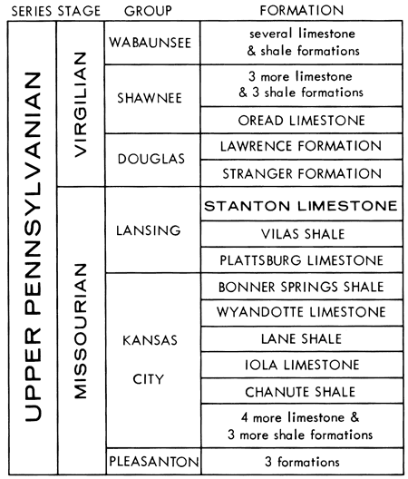
The Stanton Limestone forms the top of the Lansing Group (Fig. 1) and thus is the youngest formation of the Missourian Stage in its type region in midcontinent United States. It overlies the Vilas Shale and underlies the Weston Shale Member of the Stranger Formation (Douglas Group, Virgilian Stage). The outcrop of the Stanton Limestone extends from the Platte River Valley of eastern Nebraska through southwestern Iowa, northwestern Missouri and eastern Kansas to the Oklahoma border. Continuous exposures are limited mainly to Kansas south of the limit of Pleistocene glaciation (Fig. 2).
Figure 1--Position of Stanton Limestone in Upper Pennsylvanian sequence (after O'Connor, 1963; Zeller, ed., 1968).
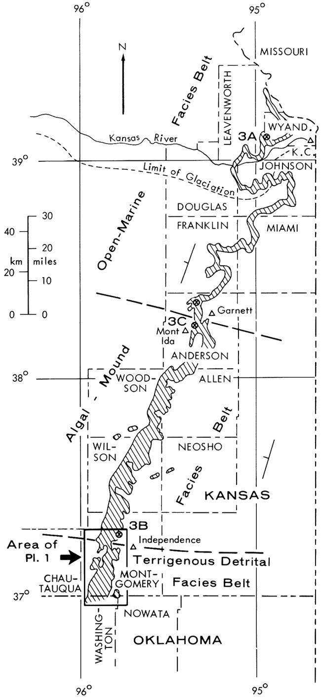
Like most other Missourian limestone units, the Stanton exhibits the regional pattern of facies belts described by Heckel (1968) and Heckel and Cocke (1969, p. 1069). Where the Stanton is developed in the northern tidal-shoreline and open-marine facies belts throughout the northern three-quarters of its outcrop as far south as east-central Kansas (Fig. 2), the formation is readily divisible into five members: three limestones separated by two shales. In southeastern Kansas, the Stanton enters the algal-mound facies belt where the three limestone members thicken into phylloid algal-mound complexes (Heckel and Cocke, 1969), while the shale members become thin and rarely exposed. Approaching the Oklahoma border in central Montgomery County, Kansas, the Stanton passes into the terrigenous detrital facies belt, where the limestone members thin abruptly and wedge out over various distances within the thickening sequence of quartz sandstone and shale. Thin limestone beds occur within the Stanton sequence in the detrital facies belt, and several do not seem to be continuous along outcrop with the familiar named members of the north.
Figure 2--Outcrop trace of Stanton Limestone (lined) in eastern Kansas (highly generalized north of Allen County), adapted and modified from State Geological Map (1964). Although boundary separating Terrigenous-Detrital Facies Belt from Algal-Mound Facies Belt is sharp (nearly coinciding with valley of Elk River at outcrop), boundary separating Algal-Mound Facies Belt from Open-Marine Facies Belt is transitional, thus only generally located. More northern Tidal-Shoreline Facies Belt does not extend into Kansas. Circled X symbols labeled 3A, 3B, 3C mark locations of measured sections in Fig. 3.
Purpose
Because wide traceability along outcrop of thin, named rock units has been shown for several Upper Pennsylvanian formations and members in the Midcontinent, continuity along outcrop has been generally assumed for many others. Such an assumption might be expected to result in a certain amount of miscorrelation. Detailed field work since 1966 has shown that misapplication of names and a certain amount of confusion have been introduced into the previous stratigraphic literature with respect to several thin limestone beds in the Stanton Formation in the detrital facies belt of Montgomery County, Kansas and adjacent Washington County, Oklahoma. [Note: Although officially named Stanton Limestone where limestone predominates throughout most of eastern Kansas, the name Stanton Formation is permissible for units of this rank and is preferable for this unit where limestone is subordinate and shale and sandstone predominate in southern Montgomery County, Kansas.] The purpose of this report, therefore, is (1) to corroborate and update the general stratigraphic framework of previously named members across southeastern Kansas, (2) to establish a more detailed stratigraphic framework of both the previously named members and newly recognized beds in the detrital facies belt at the southern extent of the Stanton Formation, (3) to trace and correlate this portion of the Upper Pennsylvanian sequence into northernmost Oklahoma where different names are in use, (4) to present general petrographic descriptions of the limestone beds that are marker units across this southern region of many diverse rock types, and (5) to describe generally the depositional regime responsible for the various units and facies. Establishing the stratigraphy, general petrography and depositional significance of identifiable Stanton units in this region provides a framework for future detailed paleontologic investigation of the well-preserved fossil assemblages in this area and for more exact interpretation of depositional environments of individual units and facies. Both procedures are necessary for further testing of suggested depositional models relating subsidence and sedimentation.
Finally, this report presents general geologic information that can be investigated in more detail by those involved in developing specific economic resources of the region. For example, it shows where lenticular sandstones and thin limestones, which often provide reservoirs and marker beds in the search for petroleum, can be studied on outcrop in order to evaluate their probable nature when encountered in the subsurface.
Prev Page--Contents || Next Page--Typical Limestone
Kansas Geological Survey, Geology
Placed on web Jan. 20, 2009; originally published May 1975.
Comments to webadmin@kgs.ku.edu
The URL for this page is http://www.kgs.ku.edu/Publications/Bulletins/210/02_intro.html