Kansas Geological Survey, Bulletin 170, part 6, originally published in 1964
Originally published in 1964 as Kansas Geological Survey Bulletin 170, part 6. This is, in general, the original text as published. The information has not been updated.
This report describes Upper Pennsylvanian rocks encountered in continuous cores taken from the Skelly Oil Company No. 1 Bartosovsky well in sec. 9, T 1 S, R 34 W, Cahoj oil field, Rawlins County, and the Stanolind Oil and Gas Company (now Pan American Petroleum Corporation) No. 3 Denker well in sec. 10, T 22 S, R 12 W, Max oil field, Stafford County, Kansas. Lithology and small-scale petrologic features of the limestones and calcareous siltstones in the cores are described in detail and illustrated in photographs.
Porosity and permeability data obtained from core analyses are shown graphically. Most porosity is related to sedimentary breccias, stylolites, masses of void-filling calcite, fractures, oolites, and fossils. Breccias and calcite masses are interpreted to have formed partly as a result of contraction of the sediment before final consolidation.
This report describes cores from the Skelly Oil Company No. 1 Bartosovsky well, SE SW SW sec. 9, T 1 S, R 34 W, Cahoj oil field, Rawlins County, and the Stanolind Oil and Gas Company (now Pan American Petroleum Corporation) No. 3 Denker well, NE NW SW sec. 10, T 22 S, R 12 W, Max oil field, Stafford County, Kansas (Pl. 1). These wells are of exceptional interest because coring was continuous in an interval from 3850 to 4245 feet in the Bartosovsky well and from 3293 to 3547 feet in the Denker well. The cored intervals span Upper Pennsylvanian rocks (upper Missourian and lower Virgilian) included in the Lansing and Kansas City Groups. In addition, rocks of the overlying Douglas Group and part of the Shawnee Group were cored in the Bartosovsky well. Long cores are seldom recovered in oil-well drilling operations in Kansas. Thus, cores of the Bartosovsky and Denker wells present an exceptional opportunity for detailed study of a sequence of limestones and siltstones, some of which serve as oil-reservoir rocks.
The goals in this study have been (1) to describe the lithology of the calcareous rocks of the cores and (2) to attempt to deduce the lithologic factors that influenced porosity and permeability in them. Improved understanding of these factors should be of help in exploring for oil in Kansas and elsewhere.
Limestones and highly calcareous siltstones in the cores were studied by means of vertically oriented acetate peels and negative photographic prints made by direct projection of the peels. The method of making peels has been outlined by Harbaugh (1959a). Peels were made from core specimens of limestones and calcareous siltstones at approximately one-foot intervals. The peels were examined with a low-powered binocular microscope. Shales and relatively non-calcareous siltstones were not studied.
Additional information about the cored intervals is provided by electric logs, which include spontaneous-potential, resistivity, and microlaterolog curves. These curves are reproduced on Plate 1. The Heebner Shale and Leavenworth Limestone are identified on the logs because of their importance as stratigraphic markers in the subsurface of central and western Kansas.
To facilitate description of the cores, depth intervals based on major lithologic changes have been assigned numbers from top to bottom. Features in the cores are described interval by interval in Tables 1 and 2.
H. O. Smedley, of the Skelly Oil Company, and H. L. Olson and G. A. Younie, of the Pan American Petroleum Corporation (formerly Stanolind Oil and Gas Company), made the cores and core analyses available for study. The cores are on file at the State Geological Survey of Kansas.
Limestones in the cores usually contain some argillaceous silty material (Fig. 1). Silt-free limestones are rare. Differentiation between silty limestone and calcareous siltstones is arbitrary because the proportion of silt is continuously variable. In spite of intergrading lithologies, different lithologic units may be readily recognized (Pl. 1).
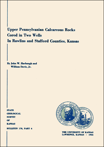
Figure 1--Calcareous siltstone. A, Denker core at 3303 feet. Laminated calcareous siltstone in which individual laminae are created by variations in silt content. Dark objects at top and bottom are calcite-filled shells. B, Bartosovsky core at 3893 feet. Calcareous siltstone containing small-scale cross-laminations. Large dark object is calcite-filled shell. Presence of high proportion of silt indicated by light tones on photograph. Arrow points to top of bed; negative peel prints, X 3 1/2 [Note: images enlarged for web use and magnification recalculated.].
Differences in rocks of the cored intervals between the two wells and between their stratigraphic equivalents at the outcrop belt in eastern Kansas (Pl. 1) are as follows: (1) Limestones in the Bartosovsky core are more silty than limestones in the Denker core; limestones in the Denker core are, in turn, more silty than limestones in the outcrop belt. (2) Limestones in the cores contain vern, small proportions of recognizable calcareous algae, whereas limestones in the outcrop belt, particularly in southeastern Kansas, are rich in calcareous algae (Harbaugh, 1959a, 1960). (3) Oo1itic limestones were not observed in the Bartosovsky core, but are present in the Denker core (Pl. 1,B) and are abundant in some stratigraphic units along the outcrop belt (Moore, et al., 1951, p. 63-90). (4) Limestones in the Bartosovsky core are more porous and permeable than those in the Denker core. (5) Limestones in both cores have numerous fine silty laminations and small-scale cross-laminations, whereas these features seem to be less common in the outcrop belt. It is probable that differences between rocks in the cores and the outcrop belt reflect major differences in environments of deposition.
Limestones in the cores display various types of small-scale sedimentary features, as follows:
Most of the limestones and calcareous siltstones have laminations created by variations in silt content. The laminations tend to be very irregular (Fig. 1,A), but some are distinctly cross-laminated (Fig. 1,B). Cross-laminations indicate deposition of discrete fine particles rather than precipitation in place (Harbaugh, 1959b).
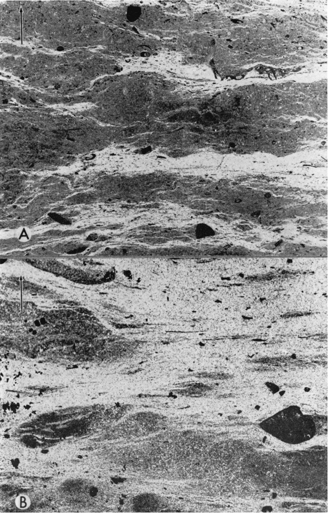
Oo1ites occur in nine zones in the Denker core (Pl 1,B), and at 3431-3432 feet in the Denker core, oolites form cross-beds (Fig. 2,A).
Figure 2--Cross-bedded oolitic limestone and sedimentary breccia in calcareous siltstone. A, Oo1itic limestone from Denker core at 3431-3432 feet. B, Calcareous siltstone from Bartosovsky core at 4093 feet. Breccia fragments do not appear to have been transported far. Fragments of relatively silt-free limestone (dark) are separated by calcareous siltstone (light). Arrow points to top of bed; negative peel prints, X 3 1/2 [Note: images enlarged for web use and magnification recalculated.].
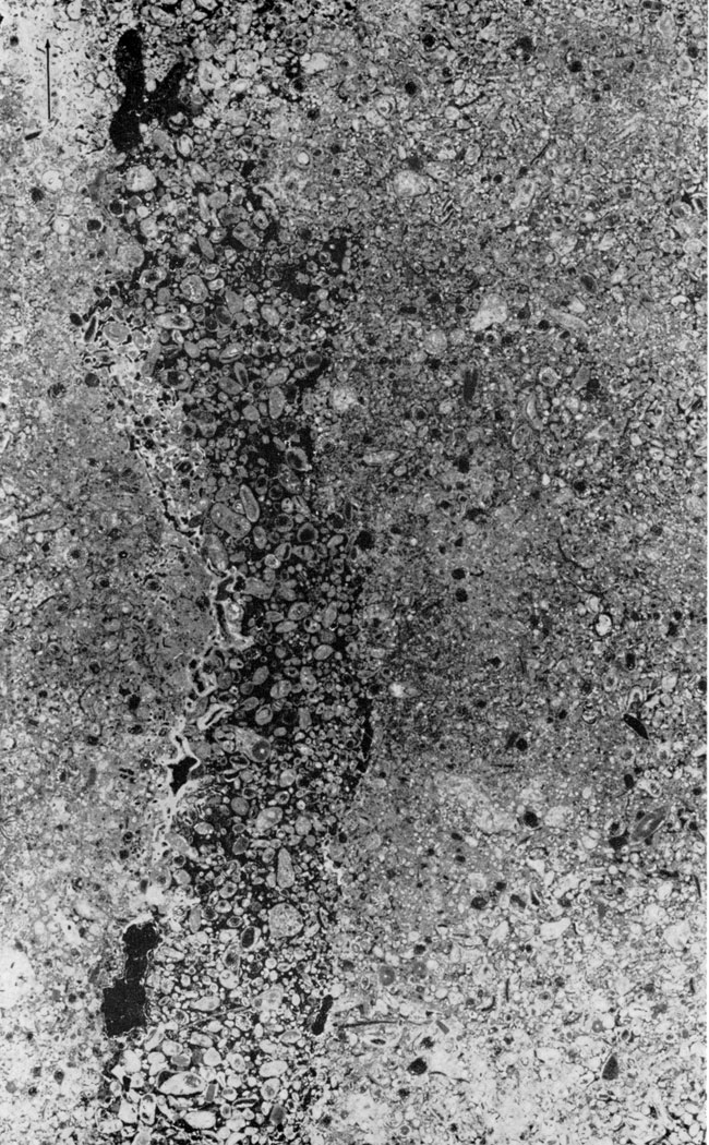
Limestone breccias occur at three horizons in the Bartosovsky core (Pl. 1,A) and at seven horizons in the Denker core (Pt. 1,B). The breccias (Fig. 2,B; 3) generally consist of subangular to highly angular fragments of low-silt limestone in a matrix of silty limestone or calcareous siltstone. The fragments are up to several inches long.
The origin of the breccias is not well understood. Some of them (Fig. 3) may have been formed by the breaking up and redeposition of weakly consolidated sediment by currents along the sea floor. If breccias were formed in this manner, however, the fragments were not appreciably rounded in the process of being transported and redeposited. Other breccias appear to have been formed as a result of the partial collapse of the sediment (,Fig. 2,B~). A cause of collapse may be contraction or shrinkage of the sediment before complete consolidation, due to the loss of interstitial water. Seemingly, this process could cause brecciation without solution of calcium carbonate. For example, if partly consolidated sediment had been exposed to the air, drying and cracking might have produced breccias. On the other hand, extensive solution of calcium carbonate probably caused other breccias. The close association of stylolites and breccias in some examples suggests that extensive solution along stylolitic boundaries may have caused local collapse and brecciation.
Figure 3--Limestone breccias. Subangular to angular fragments of low-silt limestone (dark) in silty limestone matrix (light). A, Bartosovsky core at 3975 feet. B, Denker core at 3428 feet. Arrow points to top of bed; negative peel prints, X 3 1/2 [Note: images enlarged for web use and magnification recalculated.].
Osagites, consisting largely of various sized particles coated with Osagia, occur in several beds in the Denker core. The Osagia laminae have been interpreted as representing a commensal relationship between an alga and Ammovertella, a foraminifer (Lane, 1958, p. 145).
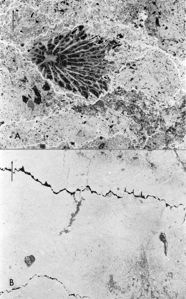
In places in the Denker core there are irregular, vertically oriented, tubelike features (Fig. 4) containing particles cemented with visibly crystalline, void-filling calcite (for a description of void-filling calcite, see Harbaugh, 1961). The tubes were probably formed by burrowing organisms before the sediment was consolidated.
Figure 4--Tubelike structure in calcarenite. Fusulinids and pellet-shaped particles which form calcarenite are relatively widely separated by void-filling calcite (dark) in tube. Denker core at 3442 feet.Arrow points to top of bed; negative peel print, X 3 1/2 [Note: images enlarged for web use and magnification recalculated.].
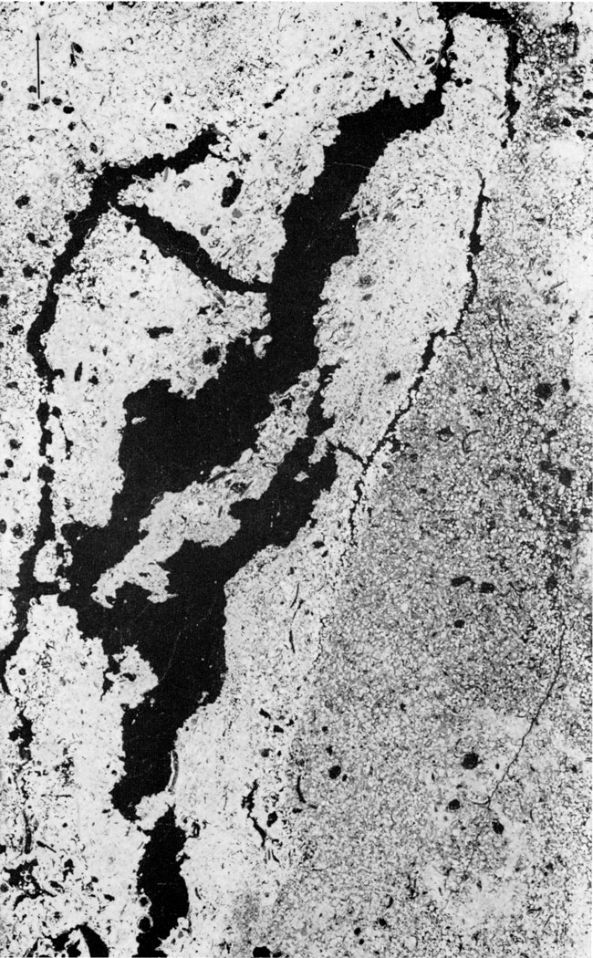
In both cores, masses of void-filling calcite locally form irregular-shaped, complexly interconnected masses (Fig. 5). The calcite is interpreted to be filling in voids produced by shrinkage and collapse of partially consolidated sediment.
Figure 5--Collapse structure filled with calcite (dark). Denker core at 3336 feet. Arrow points to top of bed; negative peel print, X 3 1/2 [Note: images enlarged for web use and magnification recalculated.]).
Irregular-shaped masses of void-filling calcite which probably formed as shrinkage-crack fillings are common in fine-grained limestones in both cores. Some of the crack or fracture fillings are narrow (Fig. 6,A), whereas others are broad (Fig. 6,B).
Figure 6--Calcite-filled fractures. A, Denker core at 3371 feet. B, Bartosovsky core at 4176 feet. Mottling may be result of burrowing organisms before sediment was consolidated. Arrow points to top of bed; negative peel prints, X 3 1/2 [Note: images enlarged for web use and magnification recalculated.].
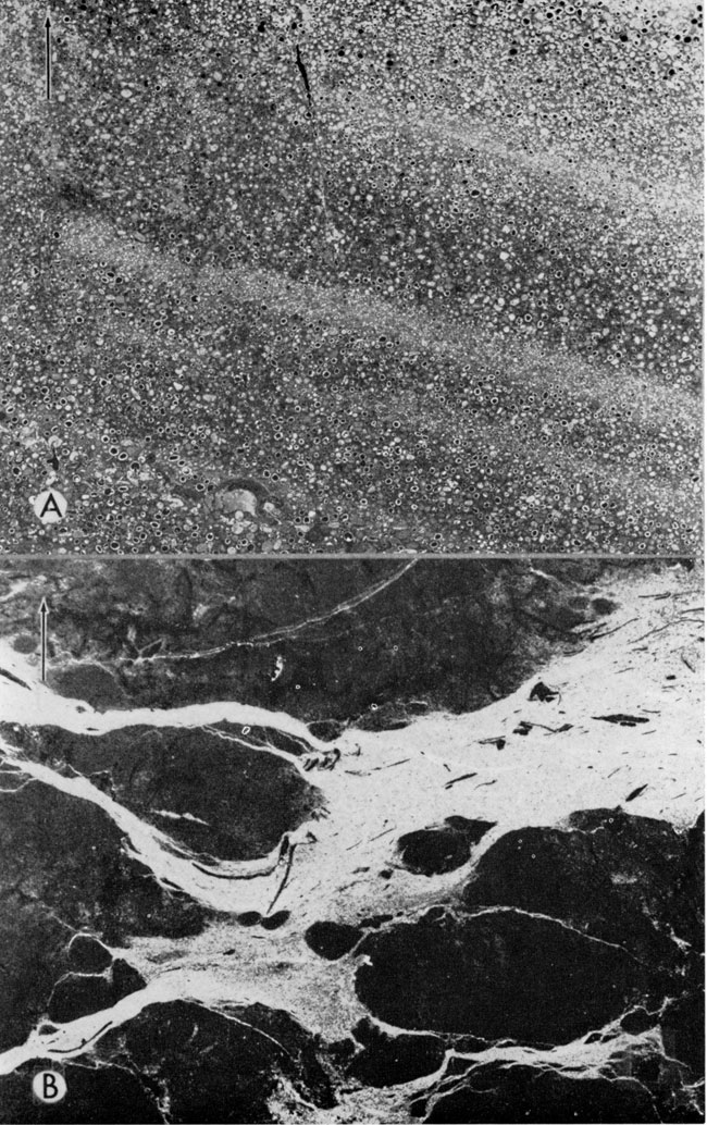
Irregular, small blebs of visibly crystalline calcite are abundant in some beds in both cores (Fig. 7). The origin of the blebs is poorly understood. Some of the blebs may be of fragmental origin (Fig. 7,A), but others (Fig. 7,B) may be fillings of gas pockets (Cloud, 1960).
Figure 7--Blebs and other small irregular masses of visibly crystalline calcite. A, Bartosovsky core at 3984 feet. Irregular masses of coarse calcite (dark) and pores (black), X 3 1/2 [Note: images enlarged for web use and magnification recalculated.]. B, Denker core at 3523 feet. Small irregular calcite blebs (dark) may fill former gas pockets that may have existed in unconsolidated sediment, X 8.5 [Note: images enlarged for web use and magnification recalculated.]. Arrow points to top of bed; negative peel prints.
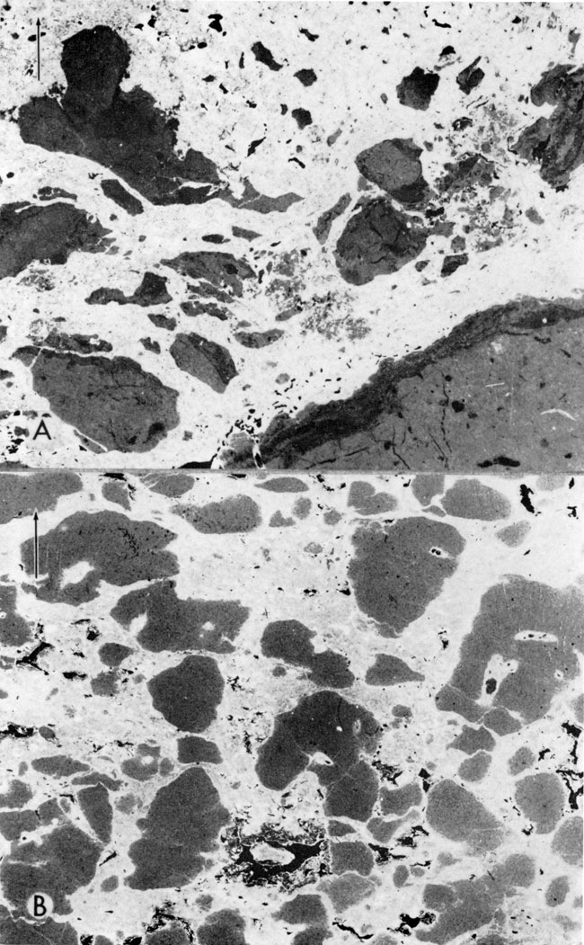
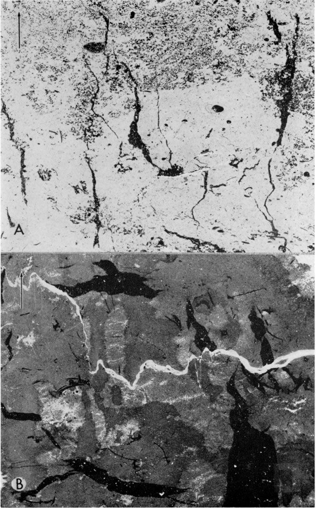
Stylolites are extremely common and in negative peel prints commonly appear as light-colored, irregular streaks (Fig. 8,A). Stylolites formed by solution of the calcium carbonate, leaving an accumulation of silt and clay, which was originally incorporated in the limestone. In some parts of the cores, the amount of carbonate material removed by solution appears to be relatively large-perhaps as much as 10 to 15 percent of the original rock volume. A rough measure of the effectiveness of solution along stylolites is provided by fossils that have been "eaten away" but whose original dimensions can be estimated (Fig. 8,A).
Figure 8--Stylolites. A, Denker core at 3324 feet. Intersecting stylolites. Note apparent loss of volume of coral due to solution along stylolite; X 8.5 [Note: images enlarged for web use and magnification recalculated.]. B, Denker core at 3400 feet. Pores (dark) associated with stylolites; X 3 1/2 [Note: images enlarged for web use and magnification recalculated.]. Arrow points to top of bed; negative peel prints.
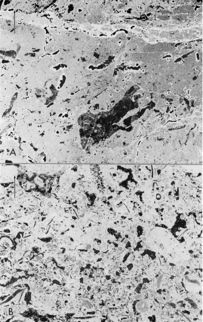
Limestones in both cores (Pl. 1) vary widely in porosity and permeability from specimen to specimen. Measured effective porosities range from 0.9 to 22.1 percent in the Bartosovsky well and from 1.6 to 17.8 percent in the Denker well. Permeabilities range from less than 0.1 to 2200 millidarcies in the Bartosovsky core, and from less than 0.5 to 34 millidarcies in the Denker core. Megascopic pores are confined principally to limestones that contain relatively small proportions of silt. Seven modes of pore occurrence may be distinguished: (11) pores of irregular size and shape that seem randomly located (Fig. 9,A) (2) pores associated with breccias; (3) those associated with stylolites (Fig. 8,B) ; (4) those associated with oolites (Fig. 2,A) ; (5) those in fractures (Fig. 9,B); (6) those occurring in places formerly occupied by void-filling calcite; and (7) those inside fossils. All of these modes intergrade with one another.
Figure 9--Porous limestones. A, Bartosovsky core at 4180 feet. Pores (dark) are mostly located at random, but some are associated with fossils. Pores are rimmed by thin residual aggregations of clay (light). B, Bartosovsky core at 3977 feet. Interconnected pores partly controlled by fractures. Residual aggregations of clay surround most pores. Arrow points to top of bed; negative peel prints, X 3 1/2 [Note: images enlarged for web use and magnification recalculated.].
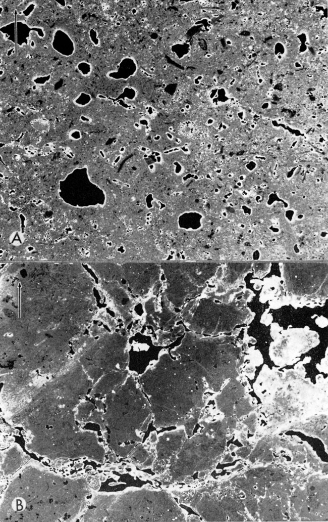
In the cores virtually all visible pores were formed by solution of calcium carbonate, as evidenced by aggregations of insoluble silt as rims around the pores. On negative peel prints the silt appears as light areas in Fig. 9).
Small interconnected pores must have been present after lithification and provided access for ground water that entered later. In some examples, factors that control distribution of pores are not readily apparent (Fig. 9,A), but in others (Fig. 9,B), small fractures seem to govern locations of pores. Perhaps fractures are actually more common than they appear to be. If so, pores whose locations seem to be random may actually be controlled by presence of minute fractures.
Pores located along stylolites (Fig. 8) and in breccias are common. Some breccias probably formed as a result of solution along stylolites. However, pore space gained through solution along stylolites has probably been much less than the volume of carbonate dissolved, because compaction and subsidence along stylolites probably has tended to destroy most of the porosity that might have otherwise been formed.
Pore size and permeability in the cores are closely related. The highest measured permeabilities in the Bartosovsky core occur in interval 18 and in the Denker core in interval 3. In these intervals the pores are up to one-half inch in maximum dimension.
Table 1--Description of Upper Pennsylvanian core from Skelly No. 1 Bartosovsky well, Rawlins County, Kansas. The core has been divided into 21 lithologic intervals, numbered from the top downward (Pl. 1,A). Stratigraphic names of intervals are given where correlations have been made.
Interval 1: 3850-3855 feet. Silty limestone and calcareous siltstone; abundant fossils include fragments of shells and crinoid stems; fossils are poorly sorted; dolomite rhombs present probably formed by replacement; megascopic pores not observed.
Interval 2: 3855 to 3875 feet. Calcareous siltstone; fossils are mostly fragments of shells and crinoid stems; small-scale cross-laminations common; porosity very low, although trains of small pores occur along fractures and within shells.
Interval 3: 3875-3890 feet. Silty, fine-grained limestone; fossils scarce, although fragments of crinoid stems are present; small-scale cross-laminations common; silty material aggregated in fine wisps along stylolites; visible pores few, but measured porosities range from 5 to 12 percent; measured permeabilities very low.
Interval 4: 3890-3923 feet. Calcareous siltstone; fossils scarce; most of rock extremely fine grained; small-scale cross-laminations common (Fig. 1,B) ; visible pores scarce although solution-enlarged fractures are present.
Interval 6: 3927-3933 feet. Silty limestone; contains some fine-grained calcarenite composed of fusulinids and fragments of crinoid stems; calcarenite is moderately sorted; sedimentary structures include small irregular-shaped pockets of calcarenite that protrude into fine, silty limestone; visible pores are mostly solution-enlarged fractures; core analyses show porosities from 1 to 17 percent, but permeabilities are very low.
Interval 7: 3933 to 3975 feet. Calcareous siltstone and silty sandstone; very few fossils; megascopic pores scarce.
Interval 8: 3975 to 3991 feet. Silty limestone; contains some fusulinid-bearing calcarenite and breccias composed of angular fragments of silt-free limestone in matrix of silty limestone (Fig. 3,A); stylolites bound some breccia fragments, suggesting that brecciation may have continued after deposition of sediment; porosities range from 3 to 13 percent, but permeabilities are very low; visible pores abundant in places, occurring at fractures (Fig. 9,B), within spaces formerly occupied by void-filling calcite, along margins of breccia fragments, and at stylolites.
Interval 9: 3991 to 4029 feet. Calcareous siltstone; contains minor proportions of calcarenite; fossils consist of fusulinids and crinoid stem fragments; visible pores scarce; measured porosities range from 3 to 19 percent, and permeabilities range from less than 1 to 35 millidarcies.
Interval 10: 4029 to 4038 feet. Silty limestone; fossils scarce, although scattered fusulinids, shells, and crinoid stem fragments are present; breccias, stylolites, and small-scale cross-laminations are present; breccias may have formed by local collapse of sediment, forming open spaces which were filled later with calcite; porosities range from about 2 to 11 percent; but permeabilities are very low.
Interval 11: 4038 to 4079 feet Calcareous siltstone; contains a single limestone bed from 4051 to 4053 feet; fossils scarce, although scattered fusulinids and crinoid stem fragments are present; visible pores scarce; porosities range from 1 to 11 percent, but permeabilities are very low.
Interval 12: 4079 to 4095 feet Silty limestone; fine-grained; fossils scarce, although scattered shells and crinoid stem fragments are present; contains breccia fragments of low-silt limestone in silty limestone matrix (Fig. 2,B); irregular-shaped masses of visibly crystalline calcite are interpreted to occupy former voids produced by shrinkage and collapse of partly consolidated sediment; visible pores scarce; porosities range from 3 to 16 percent, but permeabilities are very low.
Interval 13: 4095 to 4127 feet. Siltstone; not studied.
Interval 14: 4127 to 4139 feet. Silty limestone; fusulinids and fragments of crinoid stems are present; void-filling calcite occurs locally between breccia fragments; visible pores are abundant locally; some pores are associated with stylolites, but others appear randomly located; porosities range from 2 to 22 percent, and permeabilities from less than 0.1 to 211 millidarcies.
Interval 15: 4139 to 4145 feet. Shale; not studied.
Interval 16: 4145 to 4149 feet. Limestone; fine-grained, slightly silty; fusulinids, shells, and small crinoid stem fragments are present; visible pores are scarce; porosities range from 3 to 15 percent, and permeabilities from less than 1 to 23 millidarcies.
Interval 17: 4149 to 4168 feet. Siltstone; not studied.
Interval 18: 4168 to 4186 feet Limestone and silty limestone; fossils consist of Osagia-encrusted shell fragments; stylolites and breccia fragments are present; in places limestone is mottled; mottlings may represent burrowings; irregular-shaped small masses of void-filling calcite occur locally (Fig. 6,B). Visible pores are abundant, some up to one-half inch in long dimension; some pores occur along fractures and within fossils, but most seem randomly located (Fig. 9,A); porosities range from 2 to 20 percent, and permeabilities range from less than 0.1 to 2200 millidarcies.
Interval 19: 4186 to 4211 feet Calcareous siltstone; contains scattered shells; abundant stylolites are marked by aggregations of silt; visible pores common; some pores seem randomly located, although others are associated with stylolites.
Interval 20: 4211 to 4223 feet Silty limestone; fossils consist of small shells and fragments of crinoid stems; at 4222 feet, rock consists mostly of Osagia-coated shell fragments; porosities range from 1 1/2 to 21 percent, but permeabilities are less than 1 millidarcy.
Interval 21: 4223 to 4245.7 feet (base of core) Calcareous siltstone; low-silt limestone units occur at 4232-4236 and 4242-4244 feet; fossils are locally abundant and consist mostly of shells and fragments of crinoid stems; shell fragments coated with Osagia occur at 4242 feet.
Table 2--Description of Upper Pennsylvanian core from Stanolind Oil and Gas Company No. 3 Denker well, Stafford County, Kansas. The core has been divided into 23 lithologic intervals, numbered from the top downward (Pl. 1,B).
Interval 1: 3297 to 3315 feet Calcareous siltstone and silty limestone (Fig. 1,A) ; contains some shale at top of interval; fossils include corals, abundant crinoid stem fragments, scattered fusulinids and Osagia-encrusted shell fragments; fossil material is poorly sorted; at 3313 feet fusulinids tend to be oriented in same general direction; one-inch-thick chert layer occurs at 3307 feet; chert fills some shells, and others are filled with calcite; irregular-shaped, small masses of void-filling calcite occur throughout interval and may have formed through filling of open spaces formed by partial collapse of semi-consolidated fine-grained sediment; small-scale cross-laminations present; zones of calcareous shale up to one-half inch in thickness occur locally; visible pores not observed.
Interval 2: 3315 to 3318 feet. Shale; hard; micaceous; not studied.
Interval 3: 3318 to 3332 feet. Limestone; silty, fine-grained; calcarenite present in some zones; fusulinids are abundant at 3322 feet, crinoid stem fragments are extremely abundant at 3321 to 3329 feet, and Osagia-coated shell fragments occur at 3329 feet; pellets, fusulinids, and shells form calcarenite in interval 3321 to 3322 feet; fusulinid-rich calcarenite is moderately well-sorted, but sorting in other intervals is poor; sedimentary features include stylolites (Fig. 8,A); irregular fine laminations and small-scale cross-laminations; silt is aggregated in fine wisps along small stylolites; porosity is low except from 3326 to 3329 feet, where measured porosities are 8.8 and 16 percent, and permeabilities are near zero aDd 35 millidarcies, respectively.
Interval 4: 3332 to 3334 feet. Shale; dark gray; hard; not critically studied.
Interval 5: 3334 to 3353 feet. Limestone; silty, fine-grained; some calcarenite; small shale-filled fractures common near bottom interval; six-inch-thick unfossiliferous shale bed occurs at 3342 feet, and six-inch thick fossiliferous shale containing dense limestone nodules occurs at 3351 feet; fossils consist of shells and crinoid stem fragments; Osagia-encrusted shell fragments occur locally; sedimentary features include breccias, stylolites, collapse structures (Fig. 5), and small-scale cross-laminations; visible pores occur at fractures, within spaces formerly occupied by void-filling calcite, and at stylolites; porosities are al)out 13.5 percent at 3340 feet, but permeabilities are 3 to 4 millidarcies.
Interval 6: 3353 to 3357 feet. Siltstone; gray, hard, calcareous; dense limestone nodules are present; abundant fossils include fusulinids, bryozoans, brachiopods, and crinoid stem fragments; visible pores scarce.
Interval 7: 3357 to 3383 feet. Silty limestone; contains three, one-foot thick calcareous shale beds containing abundant shells and crinoid stem fragments; irregular-shaped patches of pyrite and scattered chert nodules occur in limestone; Osagia-encrusted shell fragments common; small-scale cross-laminations present; in places nearly vertical fractures (Fig. 6,A) are filled with calcite.
Interval 8: 3383 to 3385 feet. Shale; brown; not studied.
Interval 9: 3385 to 3418 feet. Limestone; fine-grained, dense, slightly silty; scattered fusulinids, bryozoans, shells, and crinoid stem fragments are present; stylolites common; solution-enlarged stylolites (Fig. 8,B) are marked by silty residues and pyrite crystals; locally in lower part of interval, scattered masses of pyrite and dolomite impart a mottled appearance; small chert nodules are present in lower part of interval; visible pores rare, except along some stylolites.
Interval 10: 3418 to 3423 feet. Limestone; fine-grained, silty; thin lenses of shale occur throughout interval; abundant fusulinids, and fragments of bryozoans, crinoid stems and shells occur in both shale and limestone; irregular patches of pyrite at 3421 feet impart mottled appearance to rock; oolites occur at 3422 feet, megascopic pores not observed.
Interval 11: 3423 to 3426 feet. Shale; not studied.
Interval 12: 3426 to 3443 feet. Limestone; silty, fine-grained; calcarenite containing shells and crinoid stem fragments occurs locally; sedimentary features include stylolites, irregular fine laminations, tubelike structures (Fig. 4), small-scale cross-laminations, breccias (Fig. 3,B), and cross-bedded oolite (Fig. 2,A) ; breccia fragments consist of silt-free, dense limestone; stylolites bound some breccia fragments; visible pores abundant in breccia and oolitic beds near top of interval, but porosities and permeabilities are low.
Interval 13: 3443 to 3445 feet. Shale; not studied.
Interval 14: 3445 to 3481 feet. Limestone; silty, fine-grained; unfossiliferous, dense limestones occur at 3445-3448, 3450-3452, 3460-3467, and 3478-3481 feet; calcarenite composed of fusulinids and shell fragments present in some beds; shell fragments coated with Osagia occur locally; sedimentary features include small-scale cross-laminations, stylolites, breccias, and irregular-shaped small masses of void-filling calcite; visible pores are as great as one-half inch in width; many pores appear randomly located, but some occur along fractures and stylolites; porosities range from 3 to 14 percent and permeabilities from near zero to 28 millidarcies.
Interval 15: 3481 to 3488 feet. Calcareous siltstone and silty calcarenite; fusulinids and crinoid stem and shell fragments abundant; visible pores locally abundant.
Interval 16: 3488 to 3505 feet. Limestone; fine-grained, lithographic, silty; scattered shells present; irregular-shaped, shale-filled stringers containing scattered pyrite crystals are common; mottlings from 3488 to 3493 feet may represent animal burrowings; porosities range from 1 to 5 percent, but permeabilities are very low.
Interval 17: 3505 to 3519 feet. Limestone; fine-grained, very silty; fossils include gastropods, bryozoans, and crinoid stem fragments; Osagia-encrusted shell fragments are common; some shells are filled with chert and others contain calcite; irregular fine laminations and small-scale cross-laminations are present; small megascopic pores occur in lower part of interval.
Interval 18: 3519 to 3522 feet. Siltstone; not studied.
Interval 19: 3522 to 3530 feet. Limestone; silty, fine-grained, dense; fossils most abundant near top of interval; small, irregular masses of visibly crystalline calcite (Fig. 7,B) common; stylolites and small fractures common.
Interval 20: 3530 to 3534 feet. Shale, brown, soft; not studied.
Interval 21: 3534 to 3543 feet. Limestone; silty, fine-grained; calcarenite composed of fusulinids, crinoid stem and shell fragments occur locally; small-scale cross-laminations and breccias present; irregular-shaped masses of silty limestone may be filled animal burrows; visible pores small, porosity and permeability low.
Interval 22: 3543 to 3546 feet. Shale; not studied.
Interval 23: 3546 to 3547 feet. Conglomerate; not studied.
Cloud, P. E., Jr., 1960, Gas as a sedimentary and diagenetic agent: Amer. Jour. Sci., v. 258-A, p.35-45.
Harbaugh, J. W., 1959a, Marine bank development in Plattsburg Limestone (Pennsylvanian), Neodesha-Fredonia Area, Kansas: Kansas Geol. Surv., Bull. 134, pt. 8, p. 289-331. [available online]
Harbaugh, J. W., 1959b, Small scale cross-lamination in limestones: Jour. Sed. Pet., v. 29, p. 30-37.
Harbaugh, J. W., 1960, Petrology of marine bank limestones of Lansing Group (Pennsylvanian), southeast Kansas: Kansas Geol. Surv., Bull. 142, pt. 5, p. 189-234. [available online]
Harbaugh, J. W., 1961, Relative ages of visibly crystalline calcite in late Paleozoic limestones: Kansas Geol. Survey Bull. 152, pt. 4, p. 91-126. [available online]
Lane, N. G., 1958, Environment of deposition of the Grenola Limestone (Lower Permian) in southern Kansas: Kansas Geol. Surv. Bull. 130, pt. 3, p. 117-164. [available online]
Moore, R. C., Frye, J. C., Jewett, J. M., Lee, Wallace, and O'Connor, H. G., 1951, The Kansas rock column: Kansas Geol. Surv. Bull. 89, p. 1-132. [available online]
Kansas Geological Survey, Upper Pennsylvanian Calcareous Rocks Cored in Two Wells In Rawlins and Stafford Counties, Kansas
Placed on web June 28, 2010; originally published in Dec. 1964.
Comments to webadmin@kgs.ku.edu
The URL for this page is http://www.kgs.ku.edu/Publications/Bulletins/170_6/index.html