Kansas Geological Survey, Bulletin 170, pt. 4, originally published in 1964
Originally published in 1964 as Kansas Geological Survey Bulletin 170, pt. 4. This is, in general, the original text as published. The information has not been updated. An Acrobat PDF version (3.1 MB) is also available.
A total of 63 wells drilled in Kansas during 1963 encountered buried Precambrian rock. Information on these wells, a list of completed projects, and the status of current projects of the Kansas Geological Society's Basement Rocks Committee are included in this report. The total number of wells known to have been drilled into Precambrian rocks in Kansas at the end of 1963 is approximately 2,400.
The Kansas Basement Rocks Committee was organized in 1958 in order to promote interest in Precambrian studies and to collect and preserve data on Precambrian rocks in Kansas. It functions under the auspices of the Kansas Geological Society in cooperation with the Kansas Geological Survey, with Virgil B. Cole as chairman. Much effort has been put forth to catalog all wells in the State that reached the Precambrian basement and to locate the well cuttings or cores taken from these wells. The task has been great, because to date almost 2,400 wells have encountered basement rock. This function of the Committee is nearly complete and the second phase—that of interpretation of the accumulated data—is underway.
This report is the third in a series of publications listing additions to the original list of wells, issued in 1961 as Bulletin 150 of the Kansas Geological Survey.
The Precambrian basement is of interest and importance for several reasons: (1) An understanding of the cause of geologic and tectonic developments now observable in the sedimentary rocks may be enhanced by more complete knowledge of the basement rocks. (2) Ore deposits of commercial value are known to occur in Precambrian rocks in areas surrounding Kansas, and there is no reason to doubt that similar ore deposits underlie Kansas. The search for buried ore deposits is extremely difficult, and it is best undertaken by geophysical investigations. The presence of the important iron ore deposits now being developed at Pea Ridge, Missouri, was indicated by geophysical tests. Petroleum is known to occur in weathered and fractured Precambrian rocks, especially along the Central Kansas Uplift. (3) Seismic investigations, involving the study of frequency dispersion of surface waves from quarry blasts and earthquakes, and gravity investigations, involving the measurement of very small changes in the earth's gravity field, have yielded significant information about basement rocks and depth to the Moho discontinuity.
The object of the basement investigations is twofold: to aid in the interpretation of the complex history of these rocks and the unraveling of subsequent geologic history, and to aid in the exploration for hidden mineral wealth. It is hoped that the dissemination of the collected data will benefit all serious students of Precambrian geology.
We would like to thank all companies and individuals who have supplied and checked information. Other members of the Committee, L. H. Cornell, P. C. Franks, P. L. Hilpman, and R. P. Lehman, have helped in various ways. A list of Precambrian wells maintained by the Kansas Survey's Oil and Gas Division, from information supplied by Data, Incorporated, and other sources, was helpful in preparing this report.
We would especially like to thank J. L. Kulp, of the Lamont Geological Observatory of Columbia University, and S. S. Goldich, of the U. S. Geological Survey, for age determinations performed on some Kansas core samples. E. G. Lidiak and R. E. Denison have coordinated with our work that of the Basement Rocks Project, directed by W. R. Muehlberger and supported by the Advanced Research Projects Agency. The U. S. Geological Survey, through the courtesy of H. C. Wagner, furnished the physical property analyses of Kansas rock samples. R. W. Scott, of The University of Kansas, has contributed information and graciously checked data on individual wells.
Several projects under the sponsorship of the Committee have been completed. The following reports have been published and are available:
These publications, for the most part, report only interim progress, and many aspects of the basement rocks need to be studied in greater detail.
Presently, several projects of the Committee are being completed. A list of wells producing from Precambrian rock has been compiled. The petrology of the basement rocks, as well as the overlying rocks, is being investigated in detail. The contact between the basement and the overlying Paleozoic rocks was cored in two wells in northwestern Kansas, and a study of this contact is the subject of a report soon to be published in a Kansas Geological Survey Bulletin.
For ease in updating data, the Precambrian well information will be transferred to punch cards as soon as possible. Keeping the list of wells current will be facilitated by data storage and retrieval methods utilizing high-speed electronic computers.
It is difficult to collect information and would be impossible without the cooperation of the petroleum industry in Kansas. Donations of Precambrian well cores or samples to the Committee are welcomed. Information on the Precambrian in Kansas is on file in the offices of the State Geological Survey of Kansas at The University of Kansas, Lawrence, and is available to anyone upon request.
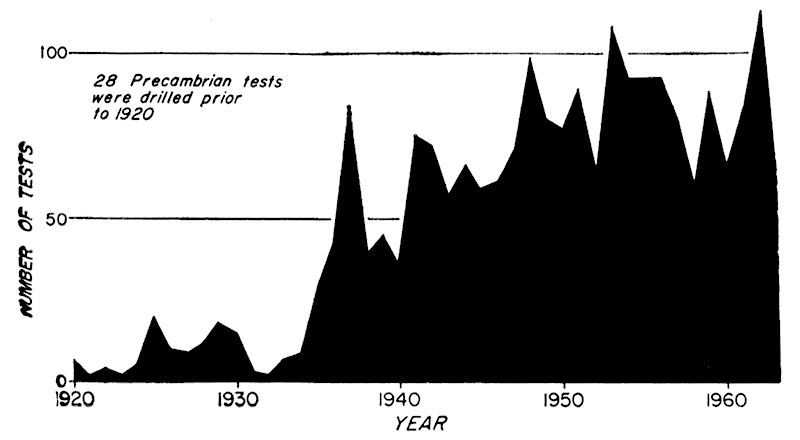
Few wells were drilled to the Precambrian before 1935, but since that time information has accumulated rapidly (Fig. 1). Since 1940, more than 50 wells to basement rock have been reported every year, and more than 100 wells were drilled to the basement in two of those years. This increase in basement wells, in spite of a decrease in explorational drilling, reflects the use of Precambrian and lower Paleozoic rocks for the permanent disposal of produced brines (E. D. Goebel, personal communication). Until the organization of this Committee in 1958 by the Kansas Geological Society, no serious attempt was made to assemble and preserve the information systematically.
Figure 1—Number of tests recorded as encountering Precambrian rocks in Kansas, by year.
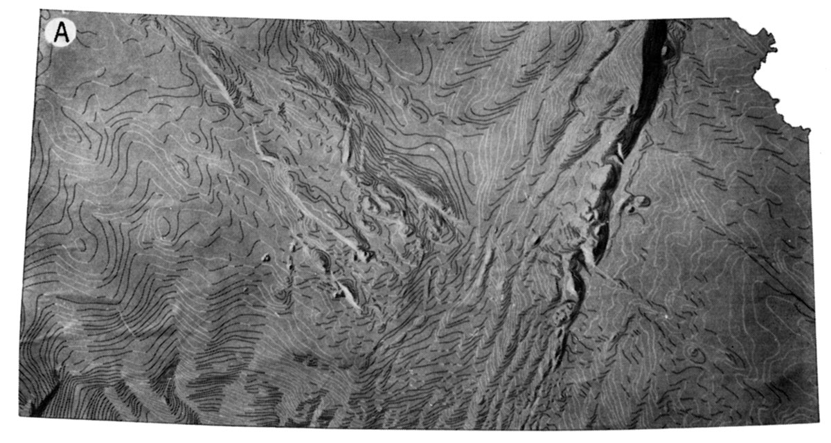
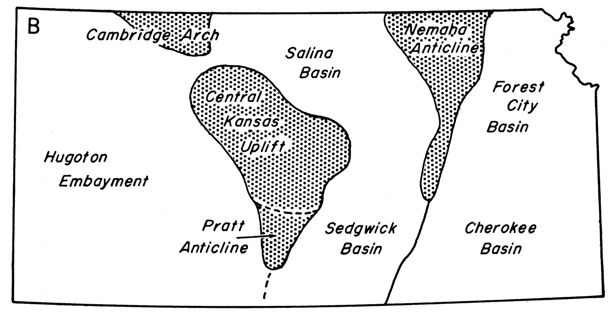
As more information accumulated, maps showing configuration of the basement surface improved in quality and included more of the State. Several maps showing configuration of the Precambrian surface have been published, and each map is an improvement over the preceding publication. The latest map, utilizing 2,200 wells, was prepared by V. B. Cole in 1962. All major late Paleozoic structural features in Kansas are recognizable on a map showing the surface configuration of the Precambrian basement (Fig. 2).
Figure 2—Maps showing: A, Configuration of buried Precambrian surface in Kansas (based on V. B. Cole, 1962, Configuration of top of Precambrian basement rocks in Kansas: Kansas Geol. Survey, Oil and Gas Inv. 26, map). The three-dimensional effect of the map is achieved by dark and light lines; positive structural features, such as the Nemaha Anticline, and negative features, such as the Salina Basin, seem to stand out in relief. The faults trending northeast and northwest, are accented. The cartographic work was done under the direction of George F. Jenks, Department of Geography, The University of Kansas; B. Major late Paleozoic structural features.
Several cores of Precambrian rock from Kansas have been dated by radioactivity methods, and the results are shown in Figure 3 at the well locations. These so-called "absolute" dates include those made by the potassium-argon and rubidium-strontium methods. Five of the dates (two in Rush County, two in Barton County, and one in Morris County) were reported by Cole, Merriam, and Hambleton in 1962. The results of six more age determinations are recorded here (Table 1).
Figure 3—Location of wells from which samples were obtained for dating by potassium-argon and rubidium-strontium methods. The age date in Woodson County is from granite exposed on Rose Dome. (Age of sample given in millions of years; age dates by rubidium-strontium in parens.)
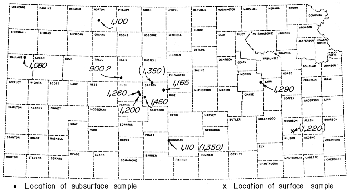
Table 1—Potassium-argon (K/A) and rubidium-strontium (R/S) dates of samples of Precambrian rocks from Kansas.
| Well name | Location | County | Rock type | Age, millions of years |
|---|---|---|---|---|
| Derby No. 4 Schoen |
sec. 35, T 3 S, R 24 W | Norton | altered metamorphic pegmatite | 1,100 (K/A) |
| quartz-feldspar schist | 1,240 (K/A) | |||
| Sinclair Prairie No. 2 Wallace |
sec. 28, T 11 S, R 39 W | Wallace | hematitic biotite schist | 1,080 (K/A) |
| Stanolind No. 1 Wann |
sec. 12, T 15 S, R 20 W | Ellis | altered granite gneiss | 900? (K/A) |
| Shell No. 4 Ehrlich |
sec. 18, T 16 S, R 13 W | Barton | biotitic quartzite | 1,350 (R/S) |
| Skelly No. 1 "A" Miles |
sec. 30, T 27 S, R 10 W | Kingman | chloritized granite | 1,100 (K/A) 1,350 (R/S) |
| Rose Dome (surface) |
sec. 13, T 26 S, R 15 E | Woodson | granite | 1,220 (R/S) |
Of special interest is a well (Skelly No. 1 "A" Miles) in Kingman County, from which two age dates were obtained by different methods, one of 1,110 million years by the potassium-argon method on biotite, and one of 1,350 million years by the rubidium-strontium method on feldspar. The age date in Ellis County is probably erroneous because the sample was extensively weathered, altering the minerals used for dating (R. W. Scott, personal communication).
An age determination made on the granite exposed at Rose Dome, in Woodson County, yielded a Precambrian date, raising speculation on the age of the intrusive and the relationship of the intrusive and granite. The granite previously had been thought to be Tertiary in age, or no older than late Cretaceous.
Table 2 reports magnetic properties and densities determined by the United States Geological Survey for Precambrian rock samples from several Kansas wells.
Table 2—Magnctic properties and densities of Precambrian rock samples from Kansas.
| Sample number* | Intensity, emu/cc | Susceptibility† | Density, g/cc | Rock type |
|---|---|---|---|---|
| 1 | 1.35 × 10⁻⁵ | .015 × 10-3 | 2.68 | muscovite quartzite |
| 2 | too weak to measure | .015 × 10-3 | 2.60 | biotite granite |
| 3 | too weak to measure | .012 × 10-3 | 2.35 | rhyolite |
| 4 | 1.35 × 10⁻⁴ | .030 × 10-3 | 2.37 | altered diabase |
| 5 | too weak to measure | .016 × 10-3 | 2.83 | andalusite schist |
| 6 | too weak to measure | .012 × 10-3 | 2.39 | altered granite gneiss |
| 7 | too weak to measure | .012 × 10-3 | 2.65 | quartz-feldspathic schist |
| 8 | too weak to measure | .014 × 10-3 | 2.70 | quartz-feldspathic schist |
| 9 | 3.61 × 10⁻⁶ | .015 × 10-3 | 2.58 | gneissic biotite granite |
| Data, courtesy H. C. Wagner, Fuels Branch, U.S. Geol. Survey, Menlo Park, California. *All samples are not oriented; sources of the samples are: 1. Skelly No. 6 "B" Buehler, sec. 33, T 18 S, R 10 W. 2. Skelly No. 1 "A" Miles, sec. 30, T 27 S. R 10 W. 3. Skelly No. 3 Miller. sec. 21. T 18 S, R 16 W. 4. Northern Natural No. 65 Otis, sec. 10, T 18 5, R 16 W. 5. Atlantic No. 10 "A" Patzner , sec. 36, T 17 S, R 11 W. 6. Stanolind No. 1 Wann, sec. 12, T 15 5, R 20 W. 7. Derby No. 4 Schoen, sec. 35, T 3 S, R 24 W. 8. Derby No. 4 Schoen, sec. 35, T 3 S, R 24 W. 9. Texas Trading No. 1 Probst, sec. 18, T 6 5, R 19 W. † Susceptibilities are directional. |
||||
Table 3 lists for each well the county, company and farm name, location, surface elevation, depth to Precambrian; Precambrian elevation and rock type, rock unit on basement, and total depth. The wells are arranged by township and range; west ranges are listed first. Information is presented in the same format as that used in earlier published lists.
These data have been collected from a variety of sources including electric and radioactivity logs, top cards, drillers logs, sample logs, and logs of the Kansas Sample Log Service. For verification, information was compared from at least two sources wherever possible. The list includes not only boreholes completed in 1963, but also some older wells inadvertently omitted from the previous lists. Additions to this list and corrections or omissions noted should be addressed to the State Geological Survey of Kansas.
All information has been forwarded to the American Association of Petroleum Geologists Basement Rocks Project Committee and to the Basement Rocks Project of the Advanced Re search Projects Agency.
Table 3—Additional boreholes drilled to Precambrian rocks in Kansas.
| County | Company, well number, and farm |
Location | Surface elevation, feet |
Depth to Precambrian, feet |
Elevation of Precambrian, feet |
Precambrian rock type |
Rock unit on basement |
Total depth, feet |
|---|---|---|---|---|---|---|---|---|
| Norton | Pentagon No. 1 Applegate |
29-1S-24W C SE SE |
2429 | 3654 | -1225 | 8 ft. granite wash on granite |
Pennsylvanian | 3670 |
| Decatur | Walker No. 1 Knutson |
11-1S-26W E2 SW NW |
2488 | 3605 | -1117 | granite | Reagan | 3606 |
| Decatur | Gulf No. 1 Huff |
16-1S-26W C SW NW |
2417 | 3516 | -1099 | granite | Pennsylvanian | 3527 |
| Decatur | Pubco No. 1-8 Ackman-Green |
8-1S-27W C NE SE |
2606 | 3657 | -1051 | 17 ft. granite wash on granite |
Reagan | 3680 |
| Decatur | Burch No. 1 Corcoran |
28-1S-27W C SE NE |
2452 | 3550 | -1098 | 31 ft. granite wash on granite |
Pennsylvanian | 3600 |
| Norton | D&D No. 1 Brown |
5-2S-23W SW SW SW |
2442 | 3722 | -1280 | granite | Reagan | 3766 |
| Norton | Pentagon No. 1 Miller |
30-2S-24W C NE SE |
2471 | 3750 | -1279 | granite wash | Reagan | 3787 |
| Norton | McLish & Petan No. 1 Miller |
31-2S-24W C SE NW |
2472 | 3745 | -1273 | 63 ft. granite wash on granite |
Pennsylvanian | 3809 |
| Norton | Sauvage No. 1 Preston |
23-2S-25W NW NW NW |
2507 | 3786 | -1279 | 7 ft. granite wash on granite |
Reagan | 3825 |
| Decatur | Waggoner Est. No. 1 Helmkamp |
6-2S-29W C SW NE |
2761 | 4411 | -1650 | 14 ft. granite wash on granite |
Reagan | 4445 |
| Rawlins | Pan American No. 1 Prochazka |
2-2S-35W C NW NE |
3227 | 5082 | -1855 | weathered granite | Arbuckle | 5104 |
| Norton | Pentagon No. 1 "B" Henderson |
3-3S-23W SW NW SW |
2249 | 3550 | -1301 | granite wash | Reagan | 3578 |
| Norton | Pentagon No. 1 Derks |
4-3S-23W C NW SE |
2276 | 3576 | -1300 | granite | Reagan | 3578 |
| Norton | Martin & Keller No. 1 Sleffel |
7-4S-22W C NE NE |
2380 | 3846 | -1466 | granite | Reagan | 3851 |
| Norton | Hansen No. 2 Dedrick |
26-5S-21W SE NE SW |
2268 | 3768 | -1500 | 22 ft. granite wash on granite |
Reagan | 3793 |
| Norton | Chief No. 1 Armstrong |
25-5S-22W C NW NE |
2264 | 3704 | -1440 | 6 ft. granite wash on granite |
Pennsylvanian | 3722 |
| Rooks | Pratt & Leben No. 1 Simons |
14-6S-20W SW SW NW |
2174 | 3630 | -1456 | 7 ft. granite wash on granite |
Pennsylvanian | 3640 |
| Graham | Continental No. 14 Trexler (twin) |
15-9S-21W SE NE NW |
2221 | 4096 | -1875 | granite wash | Arbuckle | 4100 |
| Russell | Sohio No. 4 Cook |
9-11S-15W NE SW NW |
1963 | 3471 | -1508 | granite wash | Pennsylvanian | 3480 |
| Ellis | Sinclair No. 8 Slimmer (OWWO) |
19-11S-16W NW NE SW |
1924 | 3947 | -2023 | granite wash | Arbuckle | 3950 |
| Russell | Home-Stake No. 0-4 "B" Baxter |
32-13S-15W C SW SE |
1907 | 3305 | -1398 | granite wash | Pennsylvanian | 3324 |
| Russell | Home-Stake No. 0-17 "C" Mermis |
32-13S-15W C NW SE |
1909 | 3353 | -1444 | granite wash | Reagan | 3355 |
| Russell | Meltzer No. 2 "B" Mermis |
32-13S-15W S2 SE NW |
1901 | 3309 | -1408 | granite wash | Pennsylvanian | 3346 |
| Russell | Home-Stake No. 0-27 "G" Carter |
33-13S-15W C SE SW |
1887 | 3291 | -1404 | granite wash | Pennsylvanian | 3313 |
| Russell | Leben No. 1 Krug |
9-14S-14W S2 SW SE |
1863 | 3282 | -1419 | granite wash | Pennsylvanian | 3285 |
| Russell | Leben No. 3 Rusch |
16-14S-14W NW NE NW |
1881 | 3298 | -1417 | granite wash | Pennsylvanian | 3303 |
| Russell | Home-Stake No. 0-34 "E" Witt |
3-14S-15W C SE SW |
1881 | 3314 | -1433 | granite wash | Pennsylvanian | 3329 |
| Russell | Home-Stake No. 0-18 Dortland |
4-14S-15W C NW NW |
1895 | 3292 | -1397 | granite wash | Pennsylvanian | 3340 |
| Russell | Home-Stake No. 0-31 "P" Witt |
4-14S-15W C SE SW |
1878 | 3267 | -1389 | granite wash | Pennsylvanian | 3290 |
| Russell | Home-Stake No. 0-33 "D" Witt |
4-14S-15W C NE SE |
1885 | 3279 | -1394 | granite wash | Pennsylvanian | 3290 |
| Russell | Home-Stake No. 0-6 "B" Mermis |
5-14S-15W C NW NE |
1905 | 3301 | -1396 | granite wash | Pennsylvanian | 3316 |
| Russell | Home-Stake No. 0-21 Dortland |
5-14S-15W C NW SE |
1895 | 3278 | -1383 | granite wash | Pennsylvanian | 3287 |
| Russell | Home-Stake No. 0-22 Dortland |
5-14S-15W C SE NW |
1886 | 3274 | -1388 | granite wash | Pennsylvanian | 3281 |
| Russell | Home-Stake No. 0-25 "C" Baxter |
5-14S-15W C NW NW |
1895 | 3290 | -1395 | granite wash | Pennsylvanian | 3302 |
| Russell | Home-Stake No. 0-26 "B" Mermis |
5-14S-15W C SW NE |
1901 | 3283 | -1382 | granite wash | Pennsylvanian | 3294 |
| Russell | Meltzer No. 2 Dortland |
5-14S-15W C SE SE |
1885 | 3267 | -1382 | granite wash | Pennsyl vanian | 3276 |
| Ellis | Petroleum Operating No. 1 Younker (OWWO) |
35-14S-19W SW SW NE |
2125 | 3990 | -1865 | granite | Reagan | 3991 |
| Barton | H-30 No. 4 "B" Schauf |
1-16S-12W SE SW SW |
1900 | 3437 | -1537 | granite? | Arbuckle | 3451 |
| Barton | NCRA No. 4 "A" Hofmeister (twin) |
5-16S-12W SW SW NW |
1823 | 3218 | -1395 | quartzite | Pennsylvanian | 3224 |
| Rush | Frontier No. 2 Lippert (twin) |
19-16S-17W SE NE SE |
2025 | 3480 | -1455 | quartzite | Pennsylvanian | 3518 |
| Rush | Frontier No. 1 Stramel |
29-16S-17W C SW NE |
2033 | 3668 | -1635 | quartzite | Arbuckle | 3676 |
| Rush | Continental No. 1 Suppes |
19-16S-l8W C NE SW |
2052 | 3642 | -1590 | 20 ft. granite wash on granite |
Reagan | 3668 |
| Barton | El Dorado No. 5 Ehler |
11-17S-11W NE SE SE |
1903 | 3544 | -1641 | quartzite | Arbuckle | 3575 |
| Barton | Raymond No. 2 Evenson |
33-17S-11W NE SW NE |
1803 | 3678 | -1875 | granite | Arbuckle | 3714 |
| Rush | Frontier No. 1 Brack |
5-17S-17W C NE |
2048 | 3580 | -1532 | granite wash | Pennsylvanian | 3617 |
| Rush | Frontier No. 1 "A" Kleweno |
16-17S-17W C SW NE |
2089 | 3576 | -1487 | granite wash | Pennsylvanian | 3599 |
| Rush | Continental No. 1 Scheuerman |
1-17S-18W SE NW SE |
2093 | 3643 | -1550 | 21 ft. granite wash on granite |
Pennsylvanian | 3668 |
| Rice | Glickman No. 1 Dohrman |
22-18S-10W NW SE NE |
1751 | 3252 | -1501 | granite wash | Pennsylvanian | 3275 |
| Rice | Chief No. 1 Sittner |
28-18S-10W N2 NE SW |
1744 | 3238 | -1494 | quartzite | Pennsylvanian | 3240 |
| Rush | Morrison No. 1 Weigt |
17-18S-16W NE SW NE |
1944 | 3457 | -1513 | 28 ft. granite wash on quartzite |
Pennsylvanian | 3489 |
| Rush | Morrison No. 2 Schneider |
17-18S-16W NE NE SW |
1950 | 3505 | -1555 | granite wash | Pennsylvanian | 3511 |
| Rush | Morrison No. 2 Pechanec |
18-18S-16W SE NE NW |
1952 | 3522 | -1570 | granite | Pennsylvanian | 3529 |
| Rush | Petroleum, Inc. No. 1 Crotinger |
12-18S-17W NE SW SE |
1959 | 3554 | -1595 | 6 ft. granite wash on granite |
Reagan | 3564 |
| Stafford | Virginia No. 2 Mueller (OWWO) |
29-21S-12W S2 NW SE |
1862 | 4220± | -2358± | granite | Arbuckle | 4230 |
| Pawnee | Alpine No. 2 Blasi |
2-21S-16W NW SE SE |
1983 | 4370 | -2387 | granite wash | Arbuckle | 4378 |
| Hodgeman | Pickrell No. 1 Hollenbeck |
13-21S-24W C NW SE |
2372 | 4777 | -2405 | rhyolite | Simpson | 4804 |
| Hodgeman | Texa No. 1 Lippoldts |
14-23S-23W C SE NW |
2294 | 5230 | -2936 | rhyolite | Arbuckle | 5232 |
| Marshall | Nelson No. 1 Brown |
29-1S-10E S2 SE SE |
1410 | 987 | +423 | 9 ft. granite wash on granite? |
Lansing-Kansas City | 1003 |
| Marshall | Continental No. 1 Neal |
5-4S-8E SW SE NE |
1443 | 1624 | -181 | granite wash | Simpson | 1715 |
| Pottawatomie | Ransopher No. 1 Washington Estate |
7-9S-8E Lot #13 NE cor. |
1315 | 2337 | -1022 | granite | Simpson | 2339 |
| Marion | CRA No. 33 Reamey |
17-21S-4E S2 NE SE |
1373 | 3070 | -1697 | granite | Lamotte | 3071 |
| Marion | Watchorn No. 26 Townsend |
5-22S-4E E2 NE SE |
1426 | 3200? | -1774? | granite | Lamotte | 3315 |
Kansas Geological Survey
Placed on web Dec. 7, 2018; originally published in August 1964.
Comments to webadmin@kgs.ku.edu
The URL for this page is http://www.kgs.ku.edu/Publications/Bulletins/170_4/index.html