
|
Original published in D.F. Merriam, ed., 1964, Symposium on cyclic sedimentation: Kansas Geological Survey, Bulletin 169, pp. 565-591 | |
U. S. Geological Survey, Menlo Park, California
Sedimentation during Pennsylvanian time in Wilson County was cyclic. Approximately 15 separate but generally incomplete transgressions and regressions of the sea are represented in the limestone, shale, and sandstone strata. Cyclothems recorded in these rocks are parts of six larger cyclic repetitions, megacyclothems. Characteristic environments prevailed during each part of the megacycle and resulted in the formation of sedimentary rocks with clearly different lithologic and faunal attributes. Ten depositional stages composing each megacycle are categorized as follows: A, fluviatile continental; B, continental to marine transitional; C, argillaceous transgressive-regressive marine; D, continental margin; E, rapid-oscillation marine; F, stagnant-water marine; G, normal transgressive-regressive marine; H, nearshore argillaceous marine; I, nearshore clearwater marine; and J, nearshore regressive marine. The sedimentary rocks that formed during these stages are described, and speculations concerning their depositional environments are given.
(Note: Publication authorized by Director, U. S. Geological Survey. The nomenclature and classification of the geologic units described in this report differ somewhat from the usage adopted by the U. S. Geological Survey.)
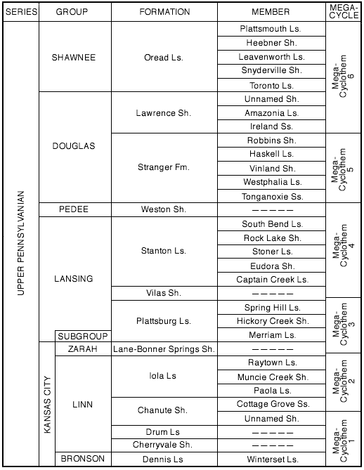
The Pennsylvanian System in Wilson County contains strata of 5 groups and 13 formations (Fig. 1). The system is characterized by sequences of limestone, shale, sandstone, and coal representing alternating marine and nonmarine depositional environments that were operative during successive advances and retreats of the Pennsylvanian sea. Each transgressive-regressive sequence defines a cycle of deposition, or cyclothem (Wanless and Weller, 1932, p. 1003), and several cyclothems are combined into larger cyclic sequences termed megacyclothems (Moore, 1936, p. 29, 30).
Figure 1--Nomenclature of exposed Pennsylvanian rocks of Wilson County.
The cyclic deposits of Pennsylvanian age in Kansas were thoroughly discussed by Moore (1936, 1949), who presented typical schemes of cyclic deposition for beds in different parts of the Kansas Pennsylvanian and Permian sequences. Although each distinctive rock type in the Pennsylvanian strata of Wilson County does not precisely fit into Moore's typical megacyclothems (1936, p. 30-34), most of the major rock units are present. Each rock type reflects deposition under different environmental conditions of water movement, water depth, water temperature, light abundance, salinity, hydrogen ion concentration, dissolved carbon dioxide, organic content, nutriment supply, abundance of land-derived matter, and other factors. On the basis of the lithologic and faunal characteristics of the strata exposed in Wilson County, 10 different sequential depositional environments, designated as stages, can be postulated as follows (Fig. 2): A, fluviatile continental; B, continental to marine transitional; C, argillaceous transgressive-regressive marine; D, continental margin; E, rapid-oscillation marine; F, stagnant-water marine; G, normal transgressive-regressive marine; H, nearshore argillaceous marine; I, nearshore clear-water marine; and J, nearshore regressive marine. Most of these 10 stages occur in each of the 6 megacyclothems into which the Pennsylvanian strata of the county are herein grouped (Fig. 3).
Figure 2--Depositional stages represented in Pennsylvanian megacyclothems of Wilson County.
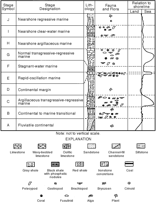
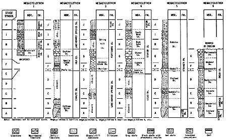
Figure 3--Megacyclothems represented in exposed Pennsylvanian rocks of Wilson County. A larger version of this figure is available.
The environmental significance of fossils and lithologies characteristic of the Pennsylvanian rocks of Wilson County are herein briefly discussed, the strata formed in each of the 10 stages are described, and their depositional environments reconstructed. In attempting reconstructions of the environments, a literature survey was made, and it was determined that opinions concerning the significance to be attached to faunal and lithologic elements in rocks are many and varied. (Note: The writer wishes at this point to express his appreciation for the constructive criticism and suggestions given by T.A. Hendricks and E.E. Glick whereby the manuscript was measurably improved.) Space does not permit a comprehensive summation of these opinions, and I have therefore made an arbitrary selection of the opinions that I feel best account for the faunal and lithologic characteristics displayed in the Pennsylvanian rocks of Wilson County. Because of the emphasis placed on Kansas rocks in his writings, I have drawn heavily on the works of R. C. Moore and his associates.
Sediments of stages A, B, D, and J contain the fossil remains of land plants; those of stage B contain pelecypods, gastropods, brachiopods, bryozoans, crinoids, and corals; and those of stages C, E, and G contain fusulinids and algae in addition to forms enumerated for stage B. Ostracodes and conodonts were found in sediments of many of the stages, but particularly those of stage F. Calcareous sponges are common in stages E, F, and G of megacyclothem 3; and cephalopods are found in stage E of megacyclothem 4.
Pelecypods and gastropods are adapted to many sorts of environments, but the vast majority are bottom dwellers in shallowmarine water (Moore and others, 1952, p. 277, 398). Myalinids and particularly Myalina (Orthomyalina) are believed to have been sedentary forms, but they were not necessarily attached by a byssus (Mudge and Yochelson, 1962, p. 105). Newell (1942, p. 19) suggested that these myalinids lived in the shallow, turbid waters of the shore zone, and could tolerate an unusually great amount of variation in the salinity of the water. Brachiopods prefer shallow water--many forms prefer very shallow water with solid objects available for attachment, others prefer muddy bottoms, and still others prefer shallow water of subnormal salinity (Moore, 1929, p. 469). Weller (1957, p. 351) suggested that the orbiculoid brachiopods found in the fissile black shale probably were attached to seaweed.
Bryozoans live mostly in shallow clear water, fairly close to shore. Some are found in water constantly agitated by waves and strong currents, and colonies are most numerous on rocky bottoms and in places where shells of other invertebrates afford places for attachment (Moore and others, 1952, p. 156). Elias (1937, p. 418-419) believed that Paleozoic encrusting bryozans lived in both the littoral and sublittoral zones, that fenestrate bryozoans were adapted for life in sublittoral regions where wave and current action were strong, and that ramose types of bryozoans were adapted for life in deep or sheltered water where wave action was absent and currents scarcely active. Concerning bryozoans, Moore (1929, p. 468-469) stated; "The nature of the enclosing sediments, perfection of preservation of delicate structures, and association with numerous crinoids, ...indicate quiet water... Presence of many shallow-water invertebrates and interdigitation of bryozoan-bearing beds and continental deposits may be interpreted as signifying depths of a very few fathoms rather than several tens of fathoms."
Modern crinoids, throughout life, generally are attached to the sea bottom by a stem, and their occurrence as fossils in Paleozoic rocks suggests a habitat of moderately shallow, quiet marine water (Moore, 1929, p. 470; Moore and others, 1952, p. 604). Crinoids need well-aerated water of relatively high minimum salinity and an abundance of suspended food matter (Clark, 1957, p. 1183). Reef corals are confined to marine water and are most abundant in clear, warm, shallow seas. They live in colonies between sea level and a depth of approximately 250 feet, but active building takes place in water less than 50 feet deep (Moore and others, 1952, p. 117-118; Wells, 1957, p. 1087-1088). Many solitary corals are firmly attached, others are loosely embedded in soft sediment, and some can endure a muddy environment (Moore, 1929, p. 468; Moore and others, 1952, p. 117). Sponges and echinoids indicate warm, clear, shallow seas (Moore, 1929, p. 468, 470).
Fusulinids are not found in direct association with fossil forms of invertebrates of the types that live today in brackish-water or nearshore environments (Thompson, 1948, p. 7); they presumably lived mainly in relatively unagitated water far from shore (Moore, 1929, p. 467-468; Thompson, 1948, p. 7). Occurrences of fusulinids in shale and sandstone suggest that they also lived in clayey and sandy environments, but the possibility should be considered that currents may have flushed the organisms into an unwholesome environment in which they died in great abundance. They were probably bottom dwellers and moved about on feeble pseudopodia; but late forms may have become adapted to a floating habit, the protoplasm in the inflated part of the shell having been distended by gaseous vacuoles (Dunbar, 1963, p. 30, 31, 41). The presence of algal incrustation in conjunction with fusulinids indicates that the water was less than 180 feet deep because below this depth photosynthetic processes essential for chlorophyll-containing algae are practically impossible, even in the clearest water (Elias, 1937, p. 425).
Ostracodes can be free swimming or bottom dwelling, and can live in foul, stagnant water as well as in water that is clear. Conodonts are apparently the remains of pelagic organisms--not bottom dwellers--and their greater abundance in shales rich in organic matter (Moore and others, 1952, p. 733) suggests life in an environment of unagitated, foul water, although the conodonts themselves may have lived near the surface where the water was better aerated (Moore, 1929, p. 472). Calcareous sponges live only in shallow water of full oceanic salinity and are most abundant at depths of less than 30 feet (deLaubenfels, 1957, p. 1083). Cephalopods, using Nautilus as an example, live in normal sea water at depths of about 10 to 2,000 feet, but generally at shallow depths. At night they migrate from deeper into shallower water and come quite close to shore. Nautilus is not pelagic, living near or on the bottom, but swims freely (Stenzel, 1957, p. 1137). It is possible that the empty shells, rising to the surface after death of the animal, were widely distributed by winds and currents (Moore and others, 1952, p. 341).
Faunas interpreted by Moore (1949, p. 81) as representing very nearshore conditions include inarticulate brachiopods, certain types of calcareous brachiopods (Derbyia, Juresania) in abundance, thick-shelled clams (especially Myalina) and radially ribbed scallops (Aviculopecten and other genera), more or less common snails (especially bellerophontids), and some bryozoans. He proposed also that offshore faunal assemblages are characterized by a varied group of marine invertebrates, particularly fusulinids, and that predominance of algae indicates shallow-water deposition during the retreating phase of a marine inundation.
The environments in which these faunas and floras lived and were buried ranged from fluviatile to marine water. The water may have been rich in quartz sand, or have contained abundant clay or silt, or have been clear and very saline. Dapples (1947, p. 9596) suggested that sandstone composed predominantly of quartz but also containing abundant muscovite on bedding planes accumulated chiefly in an environment associated with large alluviating rivers emptying into regions of extensive tidal flats.
Grim (1951, p. 231) summarized that red color in an argillaceous sediment probably is due to a supply of ferric iron oxide or hydroxide from the source area and to deposition in the absence of appreciable organic matter in an oxidizing environment where the higher state of oxidation could be preserved, or possibly to rapid burial under mild reducing conditions. Green, gray, or black shale probably formed under reducing conditions whereby the iron was changed to the ferrous state. Elias (1937, p. 428) concluded that red shale that separates marine phases of two neighboring cycles is a continental deposit and indicates emergence; he believed that green shale, which in places contains Lingula or which is mottled or interbedded with red shale, represents marine deposition within the zone of tides, the green color having formed through the reducing action of organic matter upon oxides of the original red silt (1937, p. 426427). The development of ironstone concretions in shale may, in part, occur during lithification after a considerable time lapse (Krumbein and Sloss, 1951, p. 217).
Moore (1929, p. 469) stated that black platy carbonaceous shale zones represent deposition in very shallow water that was acid because of accumulated humus and poor circulation. He suggested later (Moore, 1950, p. 15) that seaweeds may have furnished most of the carbonaceous material and have grown so thickly in this shallow water that disturbance of the bottom by wind and waves was nil. Weller (1957, p. 351) also suggested that the carbonaceous material in thin fissile black shale was derived from a prolific growth of seaweed which prevented circulation of the water and whose decaying remains exhausted the oxygen adjacent to the bottom. Phosphate in the black shale may have accumulated as a result of bacterial decomposition of organic debris (Barnes, 1957, p. 304-305).
Inorganic precipitates are formed when the solubility product of some substance is exceeded. Supersaturation may be induced by physical agencies such as temperature changes, it may be associated with the removal of carbon dioxide where photosynthesis occurs, or it may be related to changes in hydrogen-ion concentration or oxidation-reduction potential brought about by the organisms. In addition, precipitation may result from evaporation in isolated lagoons and seas (Sverdrup and others, 1942, p. 951).
Present-day oolites (forming in the Great Salt Lake, Utah; on the Great Bahama Bank, Florida; and at Laguna Madre, Texas) are restricted to areas of strongly agitated water near the shoreline or in tidal channels (Eardley, 1938, p. 1371; Illing, 1954, p. 43, 69; Freeman, 1962, p. 482). In the Bahamas the oolites are typically developed near the western ends of tidal channels and on the western beaches, where fresh oceanic water has been swept onto the shallow banks and has been sufficiently warmed and stirred up to become appreciably supersaturated with calcium carbonate (Illing, 1954, p. 43). Under the constant stirring movement induced by the tides and beach wavelets within the break-point, the calcium carbonate is precipitated as concentric oolitic sheaths of aragonite on sand grains (Illing, 1954, p. 69).
Twenhofel (1932, p. 860-862) pointed out that in epicontinental seas: (1) weak tidal action and tidal currents may lead to the presence of large areas of quiet water whose bottoms are covered with black mud rich in hydrogen sulfide; (2) shoreward the water may be so shallow as to destroy the erosional effectiveness of waves for distances of several miles from shore; (3) during times of large storms, the shallowness may allow the stirring up of previously deposited materials; and (4) bottoms adjacent to low shores without streams are apt to receive fine sediments, although some bottoms near such shores may have currents sufficiently strong to bring in coarse sediments. Moore (1948, p. 126) suggested that the marginal portions of very shallow advancing Pennsylvanian seas would be fresher than normal sea water by reason of the precipitation and runoff from the adjacent land and that the marginal portions of a retreating shallow sea may have had excess salinity because of evaporation in coastal lagoons and drainage of salt from connate water in the recently exposed salt-water sediments left behind by the retreating sea. Krumbein and Sloss (1951, p. 208) pointed out that the shoreline of a shallow advancing epicontinental sea becomes progressively submerged and that a sheet sand, which results from the sorting action of water in the zone between high and low tides, will develop without the production of a typical linear beach deposit.
The environmental data just presented have been arbitrarily selected, and it should be emphasized that other conditions of deposition have been proposed for each of these lithologic types and that more than one set of conditions may have operated during the deposition of anyone rock type. However, I consider the factors cited above as those most likely to have been effective in the Pennsylvanian seas of Wilson County and have used them in speculating on the conditions under which the various rocks were deposited. The reader should keep in mind also that:
(1) The strata in which fossils are found do not necessarily indicate their environmental habitats, but may merely be their final resting places inasmuch as the animals and plants may have been brought into the area by strong currents after death; or, the animals and plants may have died in great abundance in the area as a result of a radical change in the environment, and the strata in which they are found would then indicate the new environmental conditions which brought about their death rather than those under which they lived and flourished.
(2) The lithologic continuity and constant thickness of a sequence of thin units over many hundreds of square miles indicate environmental changes of continental magnitude and are not the result of structural movement in a local area such as Wilson County but of movement of worldwide significance. Movement in Wilson County and adjacent area must have been generally downward, however, in order to allow accumulation of a continuous sequence of sedimentary rock 2,700 feet thick containing alternating marine and nonmarine sediments. Small-scale structural movements in Wilson County are known to have modified the depositional environments locally during certain megacyclic stages, but the effects were of small areal and temporal significance and are not considered herein.
(3) The fauna and flora are influenced by water or air temperature, by salinity, depth, movement, or clarity of water, or by the nutrient content in the environment, so that their significance with regard to any one factor is not clear; the thickness and lithology of the units provide a crude measure of the time involved in their deposition.
(4) The distance from, and elevation of, exposed land as the source of terrigenous contamination may have influenced the environment to a greater extent than depth of water. A similar conclusion was reached by Mudge and Yochelson (1962, p. 115).
Because the strata of Pennsylvanian age in Wilson County are parts of repetitious sequences, members of different formations have had similar modes of origin and have the same or nearly the same lithologic and faunal characteristics. To describe each member or formation in detail would lead to much duplication. In the following sections, therefore, the stratigraphic unit that displays most completely the characteristics of each depositional stage is discussed in detail and any striking differences or similarities in thickness, lithology, or fauna displayed by correlative units are pointed out. The environment of deposition of the rocks deposited during each stage is reconstructed, and differences in the depositional environments of the correlative units are indicated.
In Wilson County, deposition during the fluviatile continental stage is represented by the lower parts of the Cottage Grove Sandstone Member of the Chanute Shale, Tonganoxie Sandstone Member of the Stranger Formation, and Ireland Sandstone Member of the Lawrence Shale (Fig. 3). The Ireland (megacyclothem 6) exhibits most completely the characteristics of the fluviatile continental stage and will be used as the example.
Physical Characteristics
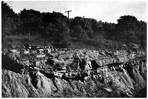
Inasmuch as megacyclothemic deposition terminates with a general withdrawal of the sea, the oldest beds in a new megacyclothem--those constituting the fluviatile continental stage--commonly are deposited upon irregular erosion surfaces. Sandstone of the lower part of the Ireland fills channels cut as much as 60 feet into the underlying shale and commonly is strongly cross-bedded. The basal part of such a channel fill is well shown in a roadcut on Kansas Highway 96 about 6 miles northwest of Fredonia (Fig. 4). At this locality abundant fragments of light olive-gray shale from the underlying strata occur in the medium- to fine-grained sandstone of the lowermost 2 inches of the Ireland. Irregularly distributed elongate pods of siltstone and sandstone that contain much finely broken carbonaceous matter and Calamites occur in the lower 2 feet of sandstone in the exposure. The sandstone in the upper 12 feet in the roadcut is composed almost entirely of grains of subrounded well-sorted, nearly equant, fine- to very fine grained quartz in beds that are both lenticular and truncated (Fig. 4). Correlation with adjacent outcrops indicates that as much as 50 feet of subaerially deposited fine- to medium-grained, slightly micaceous quartz-rich sandstone occurs above the sandstone of the roadcut. These continental deposits locally contain thin lenses of silty claystone and sandy siltstone and are overlain by sandstone that contains marine fossils in a few places.
Figure 4--Channel-filling sandstone of Ireland Sandstone Member of Lawrence Shale. Roadcut exposure about 6 miles northwest of Fredonia, Wilson County.
The Tonganoxie Sandstone Member of the Stranger Formation and the Cottage Grove Sandstone Member of the Chanute Shale differ from the Ireland in a few characteristics that presumably reflect minor environmental modifications. The Tonganoxie differs in that the quartz grains are more angular and relatively poorly sorted, and small white mica flakes are abundant. The Tonganoxie, however, is a channel-filling sandstone as much as 60 feet thick, is coarsest at the base, and locally contains wood fragments. The Cottage Grove differs slightly in that the lower part consists of yellowish-gray, slightly micaceous, very fine grained silty sandstone that overlies strata containing a minable coal bed. The sandstone is about 45 feet thick, however, and generally is thin- and even-bedded; logs of exploratory wells suggest that the Cottage Grove fills channels cut 50 or more feet into the underlying shale.
Environment
In Ireland time in Wilson County, the initial phase of megacyclic deposition presumably began when streams that flowed across the county deposited material in largely subaerial channels cut 30 to 60 feet deep into the underlying soft strata of the preceding megacyclothem. The seaward parts of the streams probably occupied sinuous channels on tidal flats and on the adjacent submarine shelf. Delta building and reduction in stream grade or velocity apparently resulted in deposition in the lower parts of the channels of medium and fine sand containing a high proportion of plant debris, including Calamites. As the streams continued to meander and spread across the flood plains and delta areas, much fine sand was deposited in locally broad cross-beds, in plane-surfaced layers, or in thick unbedded units. Thirty to 50 feet of fine to medium sand and silt accumulated thusly, and the channels were mostly filled before the transgressing sea terminated the continental deposition.
During Tonganoxie and Cottage Grove times, previously cut channels were apparently also available for subaerial filling. Somewhat different source rocks, however, presumably furnished the more angular and less well sorted quartz grains and abundant small white mica flakes deposited during early Tonganoxie time. In early Cottage Grove time the source area for the materials transported by the streams must have been more distant, or the stream gradient less, so that only very fine sand and silt were carried to the depositional environment.
The continental to marine transitional stage contains strata deposited under both nonmarine and marine conditions. The stage is represented by the upper part of the Ireland Sandstone Member and most of the strata in the overlying unnamed part of the Lawrence Shale, middle and upper parts of the Tonganoxie Sandstone Member of the Stranger Formation, and middle and upper parts of the Cottage Grove Sandstone Member of the Chanute Shale (Fig. 3). The Lawrence Shale (megacyclothem 6) will serve as the detailed example.
Physical Characteristics
The widespread sandstone beds of the upper part of the Ireland Sandstone Member of the Lawrence Shale are locally as much as 40 feet thick, but in many places they are separated into three units by two lenticular beds of shale 10 to 20 feet thick. These upper sandstone units of the Ireland are commonly grayish orange to moderate brown and are composed almost entirely of well-sorted, subrounded, very fine grained quartz. Small concentrations of limonite in many places cement the quartz grains and impart a speckled appearance to the rock; mica flakes are rare. The upper sandstone beds commonly have well developed ripple marks on which worm? tracks are locally abundant. Casts of crinoid stems, low-spire gastropods (Worthenia? and others) , pelecypods (Wilkingia, Nuculana, Schizodus?, and Aviculopecten), and brachiopods (Crurithyris and others) were found in a few places in the lower sandstone unit and locally in the upper sandstone beds. The intervening shale units generally are light olive gray, and silty or sandy.
The part of the Lawrence Shale above the sandstone consists of light-gray to light olive-gray generally silty shale that is overlain by fossiliferous limestone. This limestone, the Amazonia Limestone Member of the Lawrence Shale, consists of 5 to 18 inches of yellowish-gray to light brownish-gray, medium-grained, sparsely fossiliferous, sandy, slightly micaceous limestone or very light gray to very pale yellowish-brown, very fossiliferous limestone. The sand grains in the sandy limestone are mostly moderately well sorted, subangular, nearly equant fine-grained quartz. Fossils in the Amazonia include crinoid stems and calyx parts; encrusting, ramose, and fenestrate bryozoans; productid and echinoid spines; small horn corals; brachiopods (Juresania, Derbyia, and Chonetes); pelecypods (Aviculopecten) ; and many unidentified shell fragments. The Amazonia is overlain by about 6 feet of dark reddish-brown and moderate olive-gray slightly silty unfossiliferous claystone from which many small ironstone concretions weather. Above the concretionary claystone is a 4-foot dark reddish-brown claystone that has large irregular areas of pale-olive claystone throughout. Reddish-brown and nearly white calcareous nodules 1/8 inch to 6 inches in length, as well as small euhedral gypsum crystals, weather from this unit. The next overlying 8 feet of claystone is mottled light gray and moderate reddish orange and also is unfossiliferous. Immediately above the unfossiliferous reddish-orange claystone is a dusky-blue claystone about 12 inches thick. Although no root systems were found in place, the claystone is unbedded, has a marked plasticity, and probably represents the deeply weathered material of an underclay. The underclay? is overlain by 2 to 4 inches of coal that generally contains argillaceous layers at the middle and near the top. About one-third of the coal bed is vitrain and fusain, about one-third is attrital coal, and about one-third is argillaceous (bony) coal.
The middle and upper parts of the Tonganoxie Sandstone Member of the Stranger Formation consist of a sequence of alternating thin beds of ripple-marked micaceous siltstone and silty claystone. This sequence is missing in the southern part of the county and apparently is replaced by massive sandstone. Farther north in Kansas several coal beds occur in the upper part of the Tonganoxie (Moore, 1936, p. 149). None is present in Wilson County, however.
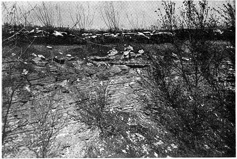
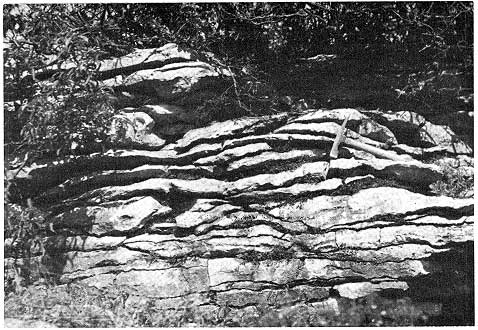
The middle part of the Cottage Grove Sandstone Member of the Chanute Shale consists of about 15 feet of very light gray, platy, carbonaceous siltstone in which the bedding locally dips northwest at about 10 degrees (Fig. 5). Many well-preserved fern leaves occur amid abundant small carbonized plant fragments on the finely micaceous bedding planes. The ripple-marked bedding surfaces and crossbedding at a few localities suggest currents moving from south to north. Three sequences of coal beds occur in the Chanute Shale, one at the top of the platy carbonaceous siltstone and two below. Each coal sequence is of small areal extent and consists generally of two or three thin coals separated by three or more inches of carbonaceous claystone.
Figure 5--Platy siltstone beds in upper part of Cottage Grove Sandstone Member of Chanute Shale. Dunbar strip pit about 6 miles southeast of Altoona, Wilson County.
Environment
In late Ireland time the sea seems to have moved across Wilson County leaving in its wake a shoreline to shallow-water blanket sand that completely filled any remaining channels and overtopped the intervening areas. Brachiopods, gastropods, and pelecypods presumably grew in the nearshore marine water while offshore, beyond the influence of strong wave and current action, clay and silt apparently formed the base for growth of a crinoid community. A few crinoidal remains were carried shoreward during times of storms. Local reduction in wave action, current movement, or size of material furnished by streams resulted in the nearshore deposition in many places of relatively thick layers of clay and silt interbedded with and overlain by sand. In early late Lawrence time the preponderance of clay and silt furnished to the sea created conditions inhospitable to marine plant and animal life in much of the area. A layer of barren silty clay many feet thick accumulated over most of Wilson County. In shallow water where temperature, salinity, and other factors were satisfactory, however, faunas rich in bryozoans, echinoids, solitary corals, brachiopods and pelecypods thrived locally and their remains were concentrated by wave and current action into thin, discontinuous coquinoidal limestone deposits. A very few organic remains were carried into carbonate-rich habitats lacking in nutrients, along with grains of fine quartz sand, and were enclosed in an iron-rich calcareous precipitate. As the sediments compacted, water highly charged with soluble iron moved through the silty clays along slightly more permeable zones, and the iron precipitated into beds and lenses of ironstone concretions.
Presumably the advance of the sea halted, and deeply weathered reddish silt and clay from the adjacent land area were spread subaerially across the broad coastal belt as the marine water withdrew from the county. Possibly some of the silt and clay that was then exposed upon poorly drained flats bordering the sea was subjected to considerable weathering and also developed a reddish color due to oxidation of the iron. Within the tidal zone in some places organic matter enclosed in the sediments presumably produced a reducing environment and small areas of greenish-colored muds formed. Water charged with calcium, sulfate, and carbonate ions provided materials that precipitated into crystals of gypsum and irregular nodules of limestone.
The deeply weathered land surface underlain by these extremely fine-grained materials probably continued to be a nearly level plain on which grassy and reedy plants grew in profusion. Intermittently, streams overflowed their banks and flooded large shallow depressions on the flood-plain surface. At times the streams carried large quantities of small branches and twigs of trees and much finely broken plant material into the low areas, where they settled into and covered thin accumulations of peaty matter derived from the indigenous vegetation. At other times clay and silt formed the chief constituents carried by the flooding streams. The clay and silt later became bony layers in coal, bark or small branches and twigs formed vitrain layers, and the finely broken plant material resulted in attrital coal. The fusain fragments possibly reflect oxidation in air prior to permanent submersion.
During late Tonganoxie time micaceous sand and silt accumulated on the shallow sea bottom adjacent to a low-lying land area, and gentle wave and current action time after time produced ripple-marked surfaces that were covered by thin accumulations of silty clay. Laterally, near the mouths of rivers, sand alone accumulated into thick deposits concurrently.
During middle Cottage Grove time, predominantly silt-size material was carried by sluggish streams to form broad deltas along a quiet shallow sea. The silt was spread laterally and formed into even-surfaced layers upon whose upper surfaces accumulated the finely broken remains of ferns and other plants that grew in profusion on the subaerial part of the delta and the adjacent coastal plain. During Cottage Grove time peat-filled swamps formed several times in local basins of small areal extent and relatively short duration. Each period of plant-debris accumulation was interrupted by an influx of clay from the adjacent land, possibly resulting from increased rainfall, from breaching of the basin border, or from both.
Deposition during the argillaceous transgressive-regressive stage is represented by fossiliferous argillaceous and calcareous sedimentary rocks in the upper parts of the Lane-Bonner Springs and Vilas Shales, Westphalia Limestone Member of the Stranger Formation, uppermost part of the Lawrence Shale, and Toronto Limestone Member of the Oread Limestone. This marine sequence is exemplified by the Westphalia Limestone Member of the Stranger Formation (Fig. 3, megacyclothem 5).
Physical Characteristics
The lower 1 to 2 feet of the Westphalia Limestone Member of the Stranger Formation consists of pale yellowish-brown fossiliferous limestone that contains an appreciable amount of iron-rich detrital material in the calcareous matrix. Impurities of clay size are most common in outcrops in the northern part of the county; silt- and sand-size impurities are most abundant in outcrops in the southern part of the county. In a few localities the clay and sand constituents are predominant, and the rock is an algal mudstone or sandstone.
Both small and large bean-shaped algae (Osagia?) are very abundant in the lower part of the Westphalia. The multiple-layered coatings that compose the algae consist of about 2 to 20 thin irregularly crenulated layers of calcium carbonate around shell fragments, oolites, small fossils, and elongate iron-oxide cores. Angular silt-size grains of quartz are abundant throughout the limestone matrix and within the algal growths and the outer chambers of fusulinids. Insoluble residues of samples contain numerous sand-agglutinated foraminifers including Tolypammina, Ammovertella, and Hyperammina amid limonite-cemented siltstone fragments, pitted grains of clear and cloudy quartz, and flakes of muscovite. Fossil fragments of echinoid spines and plates, ramose and fenestrate bryozoans, crinoid columnals, fusulinids, gastropods, pelecypods, and brachiopods locally form a large percentage of the lower part of the Westphalia. Identifiable forms include the brachiopods Composita, Crurithyris, Hustedia, Neospirifer, Punctospirifer, and Juresania; the pelecypods Astartella, Aviculopecten, and Nuculana; and the gastropods Bellerophon and Worthenia.
Six inches to 1 foot of limestone rubble, which consists of fragments of limestone covered with a white porous coating, locally separates the upper 2 to 3 feet of the Westphalia from the lower part. The upper part of the Westphalia is more widely distributed than the lower part and consists of moderate yellowish-brown impure fossiliferous limestone. Small Osagia and sparsely interspersed slender fusulinids (Triticites) show in relief on the moderate yellowish-orange weathered surface. The algal layers have formed around centers of echinoid spines and plates, ramose bryozoans, small shells and shell fragments, and quartz grains. Insoluble residues contain the foraminifers Ammodiscus, Ammovertella, Glomospira, and Tolypammina, as well as quartz grains and a few mica flakes. This stage extended into earliest Vinland time as indicated by the fusulinid-algal-brachiopod fauna in the lowermost foot of the Vinland Shale. Small gastropods, echinoid spines, bryozoans, and ostracodes are present also.
Correlative strata in the overlying megacyclothem (No. 6) locally contain a somewhat higher percentage of clayey material in the lower part of the sequence. The uppermost part of the Lawrence Shale consists of about 2 to 3 feet of medium light-gray to light olive-gray, very calcareous, fossiliferous, nodular claystone. The lower 18 inches is only sparingly fossiliferous, but concentrations of pelecypods occur locally. In the overlying part of the unit are found the identifiable remains of the brachiopods Chonetes and Dictyoclostus, fragments of other brachiopods, ramose bryozoans, crinoids, corals, and echinoids. Fusulinids, together with a few foraminifers of the genus Tetrataxis, are extremely abundant in the uppermost part where the claystone grades upward into the Toronto Limestone Member of the Oread limestone. The Toronto, in the lower part, is principally a fine- to medium-grained yellowish-gray argillaceous very fossiliferous limestone that weathers to wavy-bedded outcrop faces. Fossils occur throughout, but the fossil content varies in type and abundance both horizontally and vertically. This part of the Toronto is probably the lateral equivalent of the uppermost 3 feet of the Lawrence Shale, but exposures are too incomplete in the intervening area to provide proof of the equivalence. The fauna of the lower part of the Toronto contains pelecypods such as Myalina (Orthomyalina), Aviculopecten, and Aviculopinna; brachiopods such as Chonetes, Composita, Crurithyris, Derbyia, Dictyoclostus, Hustedia, Juresania, Meekella, Neospirifer, Punctospirifer, and Rhipidomella?; ostracodes such as Amphissites, Bairdia, and Hollinella; a lophophyllidid coral and the coral Syringopora; high- and low-spired gastropods; fenestrate, ramose, and encrusting bryozoans; the ubiquitous crinoid stems; and abundant fusulinids. In the uppermost part the Toronto has a brecciated appearance produced by angular fragments of dark yellowish-orange argillaceous limestone in a groundmass of very pale orange limestone. Cryptozoon-like algae surround crinoid columnals, horn corals, and fossil fragments.
In the rocks of megacyclothem 4, near the top of the Vilas Shale, a series of limestone beds that are intercalated in gray shale posribly represent stage C. The lower limestone beds and underlying and overlying shale contain an assemblage of pelecypods, gastropods, brachiopods, algae, corals, crinoids, and scattered fusulinids. The upper limestone beds have a brecciated appearance due to grayishorange limestone fragments surrounded by irregularly shaped seams of olive-gray calcite 1/25-inch thick.
Five to 10 feet below the top of the Lane-Bonner Springs Shale in Wilson County is a thin fossiliferous limestone bed that may represent an incomplete development of stage C in megacyclothem 3. The limestone bed and the overlying shale contain abundant crinoid stems and brachiopod fragments. These strata may, however, be representatives of other stages, for, farther north in Kansas, the Lane and Bonner Springs Shales and the intervening Wyandotte Limestone apparently contain most of the elements of an entire megacyclothem (Moore, 1949, p. 78).
Environment
In early Westphalia time abundant sand, silt, and clay apparently entered the Wilson County area from a low-lying land area to the south as the sea transgressed and the water deepened. Much soluble iron was included in this terrigenous material as it accumulated in the carbonate-rich shallow sea. Pelecypods, gastropods, brachiopods, and other shallow-water forms flourished and were buried near the shore in the sandy lime mud in the southern part of the county area. Somewhat farther north the debris from an algal-fusulinid community formed a thin deposit on the near-level sea floor. Such a community suggests that the water deepened rapidly but was very clear and high in the nutrients needed to support such a population. Presumably, as the water shallowed, the progeny of the fusulinid population retreated seaward. Bean-shaped algae, however, continued to flourish in the warm, hypersaline water of late Westphalia time, and their remains accumulated to form a thin, widespread, calcareous stratum.
In late Lawrence time streams or marine water seem to have supplied clay-size material to the shallow sea bottom. Mollusks, brachiopods, and other life presumably grew abundantly in a slightly calcareous muddy habitat. As the sea rapidly deepened, a fusulinid community rapidly populated the area of Wilson County, and their remains accumulated abundantly on the sea floor during latest Lawrence and early Toronto time. In late Toronto time, the water shallowed and Cryptozoon algae became a part of the life-community. At times the calcareous mud containing the remains of these algae, as well as crinoids, solitary corals, and other animals, was sufficiently compacted, desiccated by exposure above sea level, or cemented to permit it to break into discrete fragments when subjected to the extreme action of storm waves. The fragments were almost immediately redeposited in lime mud of slightly different character so that the fragment boundaries are well displayed in the resulting rock. Similar conditions apparently prevailed in late Vilas time. A partial oscillation of sea level may have occurred in Wilson County during Lane-Bonner Springs time, but the evidence is inconclusive.
Strata deposited at the continental margin are included in parts of the Vilas Shale, Vinland Shale Member of the Stranger Formation, and Snyderville Shale Member of the Oread Limestone. The Snyderville best typifies deposits of the continental margin stage.
Physical Characteristics
The lower two-thirds of the Snyderville consists predominantly of dark reddish-brown claystone in the lower 10 feet and pale greenish-gray silty claystone in the upper 25 feet. However, large irregular greenish-gray areas occur in the lower part, and discontinuous lenses and irregular dark reddish-brown areas occur in the upper part. Two, locally three, lenticular sandstone beds occur 10 to 15 feet above the base of the Snyderville. The beds are yellowish gray, commonly finely micaceous and calcareous, 6 to 10 inches thick, and are composed mainly of well-sorted, very fine grained quartz. Ripple marks and worm tracks? are locally common, and plant fragments were noted at one locality. About 35 and 45 feet above the base are other silty sandstone beds that are pale greenish gray to yellowish gray and very fine grained. The lower bed is locally 5 to 7 feet thick and is composed of well-sorted, very fine grained to silt size subangular quartz grains that are cemented with calcium carbonate in a few places. The upper bed is about 1 foot thick; its upper surface has markings that resemble mud cracks. Except for the uppermost foot, the upper 16 feet of the Snyderville consists predominantly of dark reddish-brown slightly silty claystone with lenticular interbeds of pale greenish-gray silty claystone. Dark yellowish-orange ironstone concretions, 1/2 to 3/4 inch in diameter, are common in some exposures. Irregular-shaped calcareous nodules, which are usually stained reddish brown on their outer surfaces and are brown, red, green, or white within, weather out of the reddish-brown claystone in local abundance. The uppermost foot consists of light olive-gray calcareous shale that contains a nearshore marine fauna consisting of pelecypods (Astartella), ostracodes (Amphissites, Bairdia, Cavellina, and Hollinella), brachiopods (Chonetes and Dictyoclostus), foraminifers (Tetrataxis and Triticites), algae (Osagia), gastropods, echinoid spines, crinoid columnals and plates, ramose bryozoan fragments, and unidentified conodont remains (Wagner and Harris, 1953).
The lower 2 to 14 feet of the Vinland Shale Member of the Stranger Formation consists predominantly of light olive-gray to yellowish-gray very slightly silty claystone. This part of the Vinland is unfossiliferous except for a few plant remains on bedding surfaces. The uppermost foot, however, is moderately calcareous and contains many large pelecypods of the genus Myalina (Orthomyalina) in conjunction with Chonetes and fragments of other small brachiopods, ramose bryozoans, corals, echinoid spines, crinoid columnals, and ostracodes. The uppermost 3 feet of the Vilas Shale is light grayish-orange fossiliferous calcareous shale containing crinoid columnals and sparse low-spired gastropods amid fragments of brachiopods, pelecypods and bryozoans. At the base of this uppermost 3 feet is a 6- to 12-inch medium-gray nodular algal (Osagia?) oolitic limestone bed. No distinct representative of the continental margin stage was recognized in the megacyclothemic sequences that include the Lane-Bonner Springs Shale and the Chanute Shale.
Environment
As the sea shallowed and receded from Wilson County during early Snyderville time, deeply oxidized material derived from the erosion of weathered rocks of the low-lying coastal-plain is thought to have accumulated as reddish silty clay upon the newly exposed land surface. Concentrations of plant remains brought about reducing conditions in small areas and the clay there became pale greenish-gray. Modification of the weather, possibly in the form of much greater rainfall, resulted in the spreading of relatively thin deposits of silt and very fine sand over the nearly level land surface, thus preserving the clay from further oxidation or reduction. Resumption of distribution of oxidized silty argillaceous material throughout Wilson County resulted in the accumulation of additional quantities of reddish clay. Again, where organic matter was concentrated, the reddish oxidized clay was reduced to a greenish color, and during short periods of excessive precipitation, layers of sand and silt were spread over the land. At times connate water saturated with calcium carbonate moved laterally through the more permeable beds, and the carbonate was precipitated in the form of calcareous nodules. Similarly, much soluble iron, which was subsequently deposited as oval-shaped ironstone concretions, may have been transported. Silty sandstone beds were cemented locally with calcite where percolating saline waters deposited their calcium carbonate between the quartz grains. Snyderville time closed with the Wilson County area again under water that prevented further oxidation or reduction of the iron in the clays and provided a habitat amenable to such shallow-water marine animals as the pelecypod Astartella and the brachiopods Chonetes and Dictyoclostus, as well as gastropods, echinoids, crinoids, and bryozoans.
During most of Vinland time the Wilson County area was possibly a coastal plain or tidal flat receiving fine silt and clay from streams draining the adjacent low-lying land area. Plant remains were brought into the area intermittently and in small quantity. Vinland time closed with the beginning of a general transgression of the sea and the establishment of a fauna consisting of large pelecypods, small brachiopods, solitary corals, echinoids, bryozoans, and ostracodes.
Land conditions apparently never prevailed during stage D in Vilas time. The sea was very shallow, however, and in latest Vilas time nearshore warm, continually agitated, relatively clear marine water made possible the growth and accumulation of abundant small oolites and Osagia? algae. Presumably the water deepened to such an extent that the sea floor was below the realm of wave or strong current action. A thick layer of clay then covered the accumulated oolites and algae, and the stage was set for the introduction of a fauna composed of pelecypods, brachiopods, crinoids, and bryozoans.
Five nearly identical limestone beds compose the representatives of the rapid-oscillation marine stage: the Paola Limestone Member of the Iola Limestone, Merriam Limestone Member of the Plattsburg Limestone, Captain Creek Limestone Member of the Stanton Limestone, Haskell Limestone Member of the Stranger Formation, and Leavenworth Limestone Member of the Oread Limestone. The Leavenworth exemplifies deposition during the stage.
Physical Characteristics
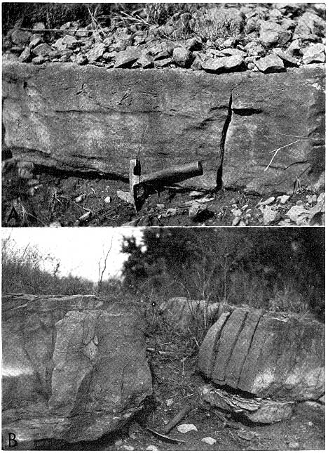
The basal 1 1/2 inches of the Leavenworth Limestone Member of the Oread Limestone consists of a fossiliferous granulite layer in which unbroken shells of brachiopods and large pelecypods are enclosed in a light brownish-gray matrix of subangular to rounded granules of limestone. Myalina (Orthomyalina) and Juresania are abundant in the matrix and are generally oriented concave side down. The remainder of the Leavenworth is medium dark-gray vertically jointed very finely crystalline fossiliferous limestone 1.2 to 1.6 feet thick (Fig. 6A). Fossil remains etch out in relief on the upper pale yellowish-brown weathered surface, and in many exposures the most distinctive feature of this surface is the presence of numerous dark oval-shaped algal bodies that range in length from 1/2 to 1 1/2 inches and in width from 3/8 inch to 5/8 inch. The algae consist of irregular concentric layers around brachiopod shell fragments, crinoid columnals, horn corals, and other shell fragments. Other fossils include echinoid spines and plates, gastropods, and brachiopods represented by the genera Marginifera, Derbyia, Composita, Juresania, and Linoproductus. Unbroken shells of small fusulinids (Triticites) are locally common in the middle and upper parts of the Leavenworth. Oolites, 1/50 to 1/10 inch in diameter, are also locally abundant near the top.
The thin vertically jointed Haskell Limestone Member of the Stranger Formation is a dense, crystalline limestone (Fig. 6B) that contains oolites, pelecypods such as Myalina (Orthomyalina), and fragments of brachiopods, fenestrate bryozoans, and crinoids in the lower part. In the upper part it is sparsely oolitic, dense, and crystalline and contains Cryptozoon? algae, brachiopod and other shell fragments, and long slender fusulinids. In the uppermost part is a veinlet-studded, brecciated-appearing, somewhat fossiliferous limestone. The entire Haskell is a single limestone bed that averages about 2 feet in thickness.
Figure 6--A, Leavenworth Limestone Member of Oread Limestone about 9 miles west of Fredonia, Wilson County. B, Haskell Limestone Member of Stranger Formation about 14 miles north of Fredonia, Wilson County.
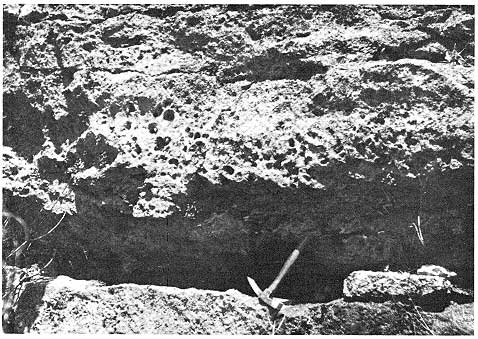
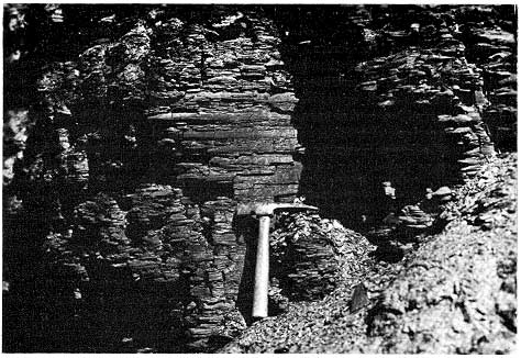
The Captain Creek Limestone Member of the Stanton Limestone consists of yellowish-gray finely crystalline algal (Osagia) and oolitic vertically jointed limestone in the lower 2 to 5 feet. Large nautiloid cephalopods are locally abundant. The remaining 5 to 10 feet of the Captain Creek is chiefly medium-gray, massive to thick-bedded cavernous limestone that weathers almost white, is deeply pitted with holes 1/2 inch to 2 inches in diameter (Fig. 7), and contains the locally abundant remains of crinoids, fenestrate bryozoans, brachiopods, corals, and fusulinids. At or near the top, the Captain Creek locally has an 8-inch zone of thin-bedded, somewhat argillaceous, red-blotched limestone that contains large pelecypods.
Figure 7--Weathered outcrop of Captain Creek Limestone Member of Stanton Limestone about 4 miles southeast of Fredonia, Wilson County.
Both the Merriam Limestone Member of the Plattsburg Limestone and the Paola Limestone Member of the Iola Limestone contain shallow-water faunas in their upper and lower parts and are single beds about 1 foot thick. The Merriam, however, is very argillaceous limestone throughout and lacks fusulinids, which are found near the middle of the Paola.
Environment
In early Leavenworth time granules and oolites of calcium carbonate presumably were oscillated back and forth in relatively clear, shallow, carbonate-rich water inhabited by large pelecypods and nearshore-dwelling brachiopods. Very shallow water, and wave or current action sufficient to move the granules were operative only long enough for a few inches of granulite to accumulate in the Wilson County area. Somewhat deeper water and more stable bottom conditions may have led to the introduction of a fauna containing brachiopods, gastropods, echinoids, crinoids, and solitary corals. Physicochemical conditions being optimum, the relatively shallow, clear water may have been warmed sufficiently to produce a gel-like calcareous precipitate on the sea floor. In such a precipitate collected the scattered remains of the indigenous animal and plant life throughout most of Leavenworth time. Calcareous algae, which formed multipIe-layered coatings around broken fragments of the remains of crinoids and other animals, as well as small fusulinids that had apparently formed local colonies on the sea floor for a short period of time when the water was deepest, were among the remains of the different life-types that were enclosed in the cryptocrystalline calcareous precipitate. Leavenworth time closed as conditions necessary for this limestone deposition became inoperative.
Haskell time also opened with a shallow-water marine environment well suited to oolitic development and growth of large nearshore-dwelling pelecypods. Bryozoans, brachiopods, and crinoids soon became the dominant faunal elements, oolitic growth virtually halted, and a precipitate similar to that postulated for Leavenworth time formed. Fusulinids became locally abundant in the fauna in late Haskell time just prior to a general shallowing of the sea. Algae (Cryptozoon) became the most abundant life form, and conditions that led to the brecciation and redeposition of semilithifled lime mud continued for a short time until Haskell deposition ended.
Captain Creek time also was a period during which the sea deepened and shallowed in a relatively short period of geologic time but probably over a somewhat longer time span and under more complex environmental conditions than operated during Leavenworth, Haskell, Merriam, or Paola times. The general deepening of the sea apparently started in late Vilas time, the water was highly charged with carbonate, was well lighted, and profuse small algae (Osagia) and oolites formed thin calcareous sediments. The algal-oolitic environment persisted, and in early Captain Creek time the unbroken shells of large nautiloid cephalopods were enclosed in a matrix of small oolites and Osagia. Laterally, in local depressions?, highly charged carbonate-rich waters formed thick flocculating masses of calcium carbonate into which the remains of brachiopods, crinoids, bryozoans, corals, and fusulinids were carried and settled. Large pelecypods that apparently lived in a nearshore environment formed the major part of the fauna in the shallow water of late Captain Creek time.
Throughout Merriam time the sea water apparently contained a high content of argillaceous material in suspension and iron in solution, and it is doubtful that the water ever attained much depth. Crinoids, sponges, brachiopods, horn corals, bryozoans, echinoids, and small and large algae either lived in the somewhat muddy water or were brought in from the clearer water of adjacent areas. The physical aspects of the sea water were, however, very similar to those that operated during the fossiliferous calcareous deposition in stage E of megacycles 2, 4, 5, and 6, and a calcareous precipitate enclosed the remains of the Merriam life-community. A marine environment well suited to invertebrate life existed in early Paola time, and bryozoans, corals, crinoids, and brachiopods grew in profusion. The water presumably deepened throughout the Wilson County area and fusulinids abounded in conjunction with a few algae. In the east-central part of the county the water remained fairly deep until near the end of Paola time, and fusulinids continued to dominate the sea bottom; but in the southern part of the county algal life alone flourished in the hypersaline shallowing water of latest Paola time and furnished abundant remains to the upper part of the dense, gel-like mass of calcium carbonate that presumably blanketed the sea floor.
Strata deposited under conditions of the stagnant-water marine stage (except for the Hickory Creek Shale Member of the Plattsburg Limestone) show the least lithologic variation of any rock type in the megacyclothem. Parts of the Heebner Shale Member of the Oread Limestone, Muncie Creek Shale Member of the Iola Limestone, Eudora Shale Member of the Stanton Limestone, and Robbins Shale Member of the Stranger Formation are typical of this stage.
Physical Characteristics
The lower 2 to 3 feet of the Heebner Shale Member of the Oread Limestone consists of nearly black fossiliferous conodont-bearing shale that breaks upon weathering into paper-thin laminae as much as 3 inches across. Finely comminuted plant remains are abundant on bedding planes in a few places. Small (1 to 2 inch) phosphatic concretions are found locally in the central part; the P2O5 content of the concretions is 32 percent (Runnels and others, 1953, p. 98). Conodonts identified by L. D. Harris (Wagner and Harris, 1953) from the Heebner in Wilson County and the immediately adjacent area include Cavusgnathus, Hindeodella, ldeognathodus, Lonchodus, Ozarkodina, Streptognathodus, and Trichognathus. Other microfossils identified are the foraminifers Ammodiscus, Cornuspira, and Tetrataxis, and the ostracodes Bairdia and Cavellina. Unidentified small fragments of bryozoans, brachiopods, and crinoids are present also.
The black shale part of the Muncie Creek Shale Member of the Iola Limestone is almost identical in character to the Heebner. It is 1 1/4 to 2 1/2 feet thick, is very fissile, breaks to paper-thin laminae, and contains abundant flattish, oval-shaped phosphatic concretions in the central part. The Eudora Shale Member of the Stanton Limestone locally contains 1 to 3 feet of almost black very fissile platy shale near the center. The black shale breaks to paper-thin laminae on whose surfaces flattened orbiculoid brachiopods are locally abundant. The lower few inches of the Robbins Shale Member of the Stranger Formation is dark gray and fissile and contains small phosphatic nodules in a few localities. The Hickory Creek Shale Member of the Plattsburg Limestone is yeIlowish-gray very fossiliferous calcareous shale in Wilson County; but farther north in Kansas the Hickory Creek has a thin carbonaceous platy shale in its lower part (NeweIl, 1933, p. 47).
Environment
The stagnant-water marine stage is thought to have been a time of poorly circulating, oxygen-poor sea water. Tidal or current movement was at a minimum, and the sea floor was a vast planar surface formed on the top of a thin layer of calcareous precipitate. GeneraIly, little or no land-derived debris reached Wilson County. Seaweed, possibly the dominant life form, essentiaIly fiIled the uppermost part of the shaIlow sea and probably had a dampening effect on wind-derived wave action. Abundant ostracodes and conodonts inhabited the water amid the seaweed, and smaIl orbiculoid brachiopods were probably attached to the seaweed and drifted to the sea floor along with the seaweed remains, there to rest in a humus-filled anaerobic environment. Phosphate accumulated as a result of bacterial decomposition of this organic debris, to be concentrated into concretions either concurrently or later during diagenesis. The small broken remains of crinoids, bryozoans, and other invertebrate life were occasionally swept into the area by unusually strong currents.
Deposits formed during the normal transgressive-regressive marine stage include the Winterset Limestone Member of the Dennis Limestone, Raytown Limestone Member of the Iola Limestone, Spring Hill Limestone Member of the Plattsburg Limestone, Stoner Limestone Member of the Stanton Limestone, very fossiliferous beds in the Robbins Shale Member of the Stranger Formation, Plattsmouth Limestone Member of the Oread Limestone, and parts of subjacent shale members as well. The upper part of the Eudora Shale Member and Stoner Limestone Member of the Stanton Limestone are typical of this depositional sequence.
Physical Characteristics
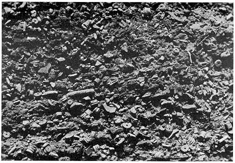
The upper 3 feet of the Eudora Shale Member of the Stanton Limestone consists of light greenish-gray calcareous shale that grades laterally into clayey limestone. Fossils include crinoid columnals, horn corals, encrusting bryozoans, echinoid spines, and brachiopod and mollusk fragments. The lower part of the Stoner Limestone Member, next above and as much as 15 feet in thickness, consists principally of blotchy-appearing medium-gray and yellowish-gray thin-bedded, wavy-bedded, and locally cross-bedded fossiliferous limestone. In many places thin beds within the Stoner are medium to coarsely crystalline coquinoid limestone made up entirely of crinoid columnals and plates (Fig. 8), echinoid plates, fenestrate bryozoans, or pelecypod and brachiopod fragments. Identifiable fossils include such genera as Meekoporella, Composita, Juresania, Neospirifer, Schizophoria, and Syringopora. In many places, relatively unfossiliferous very finely crystalline limestone predominates, and much of the Stoner is a brecciated-appearing rock consisting of angular areas of light brownish gray in a matrix of yellowish-gray limestone. Fusulinids occur locally near the top of this part of the member, and sinuous bodies of coarsely crystalline calcite, which closely resemble in form the alga Cryptozoon, are abundant in some areas. Vugs and fractures filled with sparry calcite are also conspicuous at many places.
Figure 8--Crinoidal coquina in Stoner Limestone Member of Stanton Limestone about 1 mile southwest of Fredonia, Wilson County.
The upper part of the Stoner is light-gray irregularly bedded, sparsely oolitic, finely crystalline limestone 5 to 15 feet thick. It contains fusulinids only locally in the lower part. A fauna collected from this part of the Stoner by Newell (1933, p. 136) and others at the cement plant quarry at Fredonia contained abundant remains of brachiopods, pelecypods, gastropods, corals, and crinoids.
The Plattsmouth Limestone Member of the Oread Limestone has a distinct wavy-bedded character (Fig. 9), contains brachiopods, pelecypods, gastropods, echinoid spines, and crinoid stems in the lower part, fusulinids in the upper part, and brecciated-appearing limestone in the uppermost part. The Spring Hill Limestone Member of the Plattsburg Limestone is irregularly bedded throughout and contains sponges (Heliospongia and Girtyocoelia), brachiopods (Neospirifer, Derbyia, Marginifera, Crurithyris, Echinoconchus, and Composita), solitary corals, bryozoans, and crinoids in the lower part, and Cryptozoon and bladelike? algae in conjunction with a few fossil fragments, oolites, and fusulinids in the brecciated. appearing crystalline middle part. The limestone of the Raytown is clayey, fossiliferous, locally algal, and oolitic. Oolites, algae (Osagia), brachiopods, pelecypods, and gastropods are abundant in the Winterset. During Robbins time there apparently was too much clayey contamination or insufficient calcium carbonate in the sea water to form thick limestone beds. The fauna in the shale of this part of the Robbins, however, contains pelecypods, gastropods, brachiopods, corals, etc., most of the elements found in the wavy-bedded limestones.
Figure 9--Wavy-bedded limestone of Plattsmouth Limestone Member of Oread Limestone about 9 miles west of Fredonia, Wilson County.
Environment
The normal transgressive-regressive marine stage seems to have started in Eudora time with muddy carbonate-rich water covering the Wilson County area. Bottom-dwelling pelecypods as well as horn corals, bryozoans, echinoids, and brachiopods formed much of the fauna whose remains collected in the lime-rich mud that accumulated on the sea bottom. In early Stoner time the water deepened somewhat and became clearer, and some small depressions and possibly some reeflike areas well suited to one or a few particular types of invertebrate life developed. In certain small areas the remains of crinoids formed the only faunal element in the carbonate-charged lime mud; in other places the remains were entirely those of fenestrate bryozoans or of echinoids. Physicochemical conditions suitable to calcium carbonate precipitation presumably occurred during much of middle Stoner time and thin irregularly surfaced lenticular calcareous precipitates formed overlapping wedges upon the sea floor. Very thin concentrations of clay apparently were deposited on many of these surfaces, and after lithification and exposure to weathering, the wavy-bedded character becomes apparent. Deepening of the water was probably responsible for the entry of a locally abundant fusulinid fauna, but in late Stoner time the water shallowed and algal? growth predominated as the life form in presumably hypersaline waters. Small particles were oscillated and oolites grew in the relatively shallow water in or near the habitat of a fauna consisting of pelecypods, gastropods, brachiopods, corals, and crinoids. Violent storm waves at times reached the sea floor and disrupted the semilithified bottom sediments which then settled as fragments into the unconsolidated calcareous mud that was being deposited.
The events recorded in Plattsmouth and Spring Hill times were very similar to those of Stoner time. During Raytown and Winterset time, the sea presumably deepened and then shallowed, but without reaching the depth of fusulinid activity. Robbins time was apparently dominated by argillaceous debris from the land, but not to the exclusion of faunas whose habitats ranged from shallow to relatively deep water.
Nearshore argillaceous marine deposition is represented by strata of the Cherryvale Shale, lower part of the Lane-Bonner Springs Shale, Rock Lake Shale Member of the Stanton Limestone, and middle part of the Robbins Shale Member of the Stranger Formation. The Cherryvale Shale (Fig. 3, megacyclothem 1) is considered typical.
Physical Characteristics
The Cherryvale Shale consists of as much as 40 feet of yellowish-gray to medium-gray finely micaceous, thin-bedded clayey siltstone and silty claystone. A light olive-gray hard unfossiliferous limestone bed, 9 inches thick, occurs about 14 feet above the base, and several 1/4 inch to 1/2 inch platy unfossiliferous limestone beds occur in the next overlying 2 feet. A few beds of small ironstone concretions occur below these limestone beds and also in the upper 5 feet. The lower 2 feet of the Cherryvale has current ripple marks locally.
The lower part of the Lane-Bonner Springs Shale consists of light olive-gray unfossiliferous silty claystone. Beds of unfossiliferous limestone concretions, 5 to 10 inches thick, are both underlain and overlain by claystone containing small moderately abundant ironstone concretions.
The Rock Lake Shale Member of the Stanton Limestone is poorly exposed in Wilson County but may represent this stage. It consists of locally calcareous claystone that is dark yellowish orange in the lower foot and very light olive gray in the upper foot. A marine fauna, consisting of several foraminifers and ostracodes as well as fragments of crinoids, bryozoans, echinoids, and brachiopods, was noted at a few localities.
The middle part of the Robbins Shale Member of the Stranger Formation consists of light olive-gray silty to sandy shale that characteristically contains abundant ironstone concretions. Two thin beds of moderate yellowish-brown very fine grained sandstone or sandy siltstone occur locally in this part of the Robbins.
Environment
In early Cherryvale time the Wilson County area was covered by a shallow sea whose water was presumably low in nutriments, was clouded by abundant clay and silt supplied by erosion of a nearby low-lying land area, and apparently was inhospitable to marine animal or plant life. Current action locally developed ripple marks on the surfaces of the silt and clay layers. Near the middle of Cherryvale time, the calcium carbonate content and other physical characteristics of the sea water were such that limy gels? collected on the bottoms of shallow depressions and precipitated as large discrete oval-shaped bodies or lenticular beds. Soluble iron became concentrated locally into ironstone concretions, possibly during diagenesis.
In Lane-Bonner Springs time almost identical conditions prevailed; but in middle Robbins time small amounts of sand-size detritus were distributed occasionally throughout the area and thin sandy beds accumulated upon the clayey mud. During Rock Lake time, physical and biological conditions remained locally suitable to marine life throughout this stage in the Wilson County area.
Sediments of the nearshore clear-water marine stage are found in the Drum Limestone, oolitic phase of the Spring Hill Limestone Member of the Plattsburg Limestone, South Bend Limestone Member of the Stanton Limestone, and limestone beds in the upper part of the Robbins Shale Member of the Stranger Formation.
Physical Characteristics
The lower 6 to 10 inches of the 18-inch Drum Limestone is composed of brownish-gray to medium-gray sparingly fossiliferous limestone. Broken crinoid stems are the dominant fossils and in conjunction with shell fragments of brachiopods, occur in a finely crystalline calcite matrix. The upper part is much more fossiliferous, generally is oolitic, and in the easternmost part of the county contains abundant Osagia and Cryptozoon-like algae. At a few localities the oolites, algae, and invertebrate fossil remains fill scour channels or large desiccation cracks that apparently formed in the lower part of the Drum prior to accumulation of the upper part. The oolites are much larger at the top of the bed than in the lower part and are concentrically banded; the outer rings in many are broken and stripped back or folded, possibly as a result of partial desiccation. The fauna of the upper part of the Drum consists of the brachiopods Composita, Derbyia, Echinoconchus, Hustedia, Juresania, Marginifera, Neospirifer, and Punctospirifer; horn corals and Syringopora; ramose, fenestrate, and encrusting bryozoans; crinoid stem segments and calyxes; small bellerophontid and high-spired gastropods; and Myalina (Orthomyalina) and small pelecypods.
The uppermost few feet of the Spring Hill Limestone Member of the Plattsburg Limestone consists principally of oolites and algae (Osagia?) that have diameters generally less than 1/8 inch but locally as much as 1/4 inch. The oolites are concentrated into pockets in a very finely crystalline limestone. In some of the oolites the concentric bands extend to the center of the oolite, but more commonly crinoid stem segments, shell fragments, or subangular microcrystalline limestone grains form the centers.
The South Bend Limestone Member of the Stanton Limestone is similar to the Drum and Spring Hill in being oolitic, but generally it is sandy, cross bedded, and contains a pelecypod-brachiopod fauna. It commonly contains brachiopods of the genera Rhipidomella, Punctospirifer, Hustedia, Meekella, Derbyia, Streptorhynchus, and Dielasma; and the pelecypods Streblopteria?, and Aviculopecten (Newell, 1933, Pl. 1, p. 140; 1937, p. 53). About 10 percent of the oolites have quartz grains at their centers. In a few areas, fusulinids were observed in the South Bend.
Three lenticular, locally developed limestone beds in the upper part of the Robbins Shale Member of the Stranger Formation consist primarily of the remains of Osagia? and crinoid stem segments, numerous large and small brachiopods, pelecypods, and gastropods. Small fusulinids were abundant in a thin bed in one exposure.
Environment
Early in Drum time the shallow clear sea that covered the Wilson County area apparently was not particularly suitable for marine life because of low nutriment content, excessive salinity or temperature, or some other important factor. Conditions for the precipitation of calcium carbonate, however, were apparently near optimum for a short period, and the remains of a scanty invertebrate fauna were enclosed in a viscous calcareous precipitate. In middle Drum time shallowing of the water may have brought this newly formed precipitate above low-tide level so that the upper surface became desiccated and was locally channeled by tidal-current action. Better conditions for marine life followed, as shown by the broken remains of brachiopods, corals, bryozoans, and crinoids that were carried into these desiccation cracks and tidal channels. There they were concentrated and, in conjunction with abundant oolites, were oscillated back and forth by small waves and shoreline or tidal currents. Continued oscillation and accretion during most of late Drum time led to the formation of a thin accumulation of oolites and fossil fragments throughout the Wilson County area. Occasional temporary exposure above low-tide level allowed many of the oolites to become partly desiccated and flattened. They were subsequently incorporated in the calcareous sediments of latest Drum time.
In latest Spring Hill time a shallow-water marine environment also prevailed in which small oolites and algae (Osagia) were being oscillated back and forth in carbonate-rich water by current or wave action. Time was sufficient for the oolites to form a thin, widely distributed calcareous deposit on the flat or gently undulating surface.
During South Bend time many fine-size quartz grains were carried into the shallow clear sea, were oscillated in water highly charged with calcium carbonate, and formed the nuclei of many oolites. Wave and wind action concentrated the oolites and grains of lime sand into locally cross-bedded deposits. A brachiopod-pelecypod fauna inhabited the marine water and nearshore lime mud, and their shells were added to the deposits formed during South Bend time. Fusulinids may have lived in a few scattered places in the Wilson County area, or their remains may have been brought into the area by current action.
During Robbins abundant time, the calcareous remains of marine plant and animal life formed a major part of several thin lenticular accumulations of lime mud on the shallow sea floor. Land-derived clay, however, was apparently the predominant material furnished to the sea and several times formed thick deposits upon which calcareous matter could accumulate.
The nearshore regressive marine stage brought to an end the marine phase of each megacycle; the sea then receded from the Wilson County area and erosion cut channels as deep as 60 feet into the newly deposited strata. Sediments laid down by nearshore regressive deposition occur in the lower part of the Chanute Shale, middle part of the Lane-Bonner Springs Shale, lower part of the Vilas Shale, much of the Weston Shale, and upper part of the Robbins Shale Member of the Stranger Formation. The Weston Shale will serve as the typical example.
Physical Characteristics
The Weston Shale is composed mainly of medium olive-gray claystone that is silty in the upper part, where it incorporates several beds of grayish-orange very fine grained micaceous thin-bedded sandstone. The sandstone beds are 1/8 inch to 6 inches thick and contain finely broken plant fragments. The claystone is vertically jointed and fissile and breaks readily into small rectangular fragments (Fig. 10). Ironstone concretions, one of which contained an unabraded marine gastropod, occur in lenticular beds and as separate oval bodies in the middle part of the Weston.
Figure 10--Weston Shale in brick plant quarry at West Mound, Fredonia, Wilson County.
The upper 20 to 50 feet of the Robbins Shale Member of the Stranger Formation is light olive-gray silty to sandy shale that characteristically contains abundant dark yellowish-orange oval ironstone concretions. A thin sandstone bed or sandy concretionary bed is present locally.
The lower part of the Vilas Shale is light olive-gray slightly silty claystone that locally contains thin yellowish-gray siltstone beds in the south-central part of Wilson County.
The middle part of the Lane-Bonner Springs Shale consists of medium olive-gray slightly silty claystone that contains two thin (1-inch thick) finely micaceous siltstone layers with plant fragments. Small ironstone concretions generally occur abundantly above the siltstone beds.
The lower part of the Chanute Shale consists mainly of medium-gray unfossiliferous slightly silty claystone. Near the top of this part of the Chanute is a moderate yellowish-brown spongy unfossiliferous limestone bed that becomes soft and porous on weathering.
Environment
Most of Weston time was a period of quiet, shallow marine water unaffected by strong current action. Thin even beds of clay, without ripple marks or other sedimentary structures, were the main depositional result. Paucity of nutriment and freshening of the water due to greater rainfall may have contributed to the general disappearance of the previously abundant marine fauna. However, marine gastropods which later became the nuclei for concentration of iron carbonate? were present in the muddy environment. In late Weston time the land area furnishing terrigenous debris presumably rose slightly and furnished silt and fine sand to the receding sea. An abundant land flora contributed small carbonaceous fragments to the sand and silt brought in by the rivers.
Very similar conditions probably prevailed during early Chanute time but an accumulation of iron-rich calcareous mud interrupted the clay deposition for a short period. Water and sediment conditions during parts of Lane-Bonner Springs, Vilas, and Robbins time were apparently very similar to those of Weston time.
The 13 formations of Pennsylvanian age that crop out in Wilson County may be grouped into 6 major repetitive cycles of sedimentation (megacycles) that seemingly reflect deposition in a sequence composed of 10 distinct stages. This megacyclic pattern is not perfect and all 10 stages are not represented in each of the 6 megacyclothems. Where complete, however, megacyclic deposition seems to have taken place under the conditions described below.
The megacycle began with stage A, in which fluviatile sand was deposited in deep erosional channels cut during the major period of erosion between each succeeding megacycle.
During stage B a blanket sand with a small nearshore marine faunal assemblage was deposited as the sea transgressed upon the land. Slight fluctuations in water depth and the amount of nutriments and land-derived sediments may have been the factors that led to the successive deposition of barren marine muds, sandy lime muds with crinoidal and other shallow-water remains, and silty marine clays. A slight regression presumably left the clays bared to weathering processes and oxidation for a short period during which an abundant land flora furnished materials to form a thin bed of peat.
Stage C began with a major transgression of the sea, and the peat was covered with gray silt and clay, abundantly supplied by streams from the adjacent land. The shallow nearshore water must have teemed with organisms whose remains formed a large part of the iron-rich clayey calcareous mud that accumulated on the sea floor. Apparently the water deepened very rapidly, and the remains of a shallow-water community that consisted of gastropods, pelecypods, algae, brachiopods, bryozoans, crinoids, and corals became mixed with the remains of a deeper water fusulinid fauna. Fusulinids became less abundant as the water shallowed and algae and nearshore invertebrates again were the predominant life forms.
In stage D shoreline marine and dry land conditions prevailed for a short period of time. Weathered, oxidized red clay and finegrained quartz sand from the adjacent lowlying land area formed the dominant depositional material.
As stage E began, the sea is presumed to have rapidly transgressed upon the land and covered it with a thin calcareous precipitate. This precipitate contained faunal elements that indicate a change from shallow water in which heavy-shelled pelecypods lived amid continually accreting calcareous granules and oolites, to locally fusulinid-rich deeper water, and then to shallow clear water of greater than normal salinity inhabited by abundant calcareous algae.
Stage F seems to have recorded a rather drastic change in the marine environment. Calm shallow water, which is presumed to have been low in oxygen and certain nutriments, covered the Wilson County area. Water motion was presumably reduced to a minimum by an extremely dense seaweed growth, and stagnant organic-rich bottom conditions appear to have resulted. As the seaweed died and fell to the bottom, an anaerobic resting place developed for the conodonts and ostracodes that lived in the water.
As stage G began, the calm, poorly aerated water was again subjected to tidal and wave action and a normal transgressive-regressive cycle of the sea was initiated. A fauna composed mainly of mollusks, crinoids, brachiopods, bryozoans, and corals flourished at the beginning of the stage. At about the middle, this fauna was augmented and largely replaced by a profuse fusulinid fauna and sparse algal flora, and calcareous precipitates formed irregularly shaped deposits upon the sea floor. Small amounts of clay intermittently fell to the wavy-surfaced top of the lime mud. Shortly, the water became shallower, algae became abundant, and the fauna changed again to corals, bryozoans, brachiopods, crinoids, and mollusks.
Stage H was a time of silty nearshore conditions, which, possibly as a result of very high rainfall and consequent freshening of the nearshore water, formed an environment inhospitable to marine life. Barren deposits of iron-rich clay and, locally, very calcareous silt and precipitated calcium carbonate accumulated in the shallow water.
During stage I saline water presumably drained from the compacting marine clay, adding its salt to that of the sea water; the nutriment content of the sea seemingly became higher than normal; and plant and invertebrate animal life again flourished in the Wilson County area. Brachiopod shells and crinoids, broken by strong wave action, accumulated in deposits rich in calcareous algae and oolites that formed in the continually agitated shallow water.
In stage J the megacycle closed with slight uplift in the land area and influx into the sea of sand and silt as well as clay. The marine population slowly migrated seaward, generation after generation, as its chosen habitat moved; the water shallowed and disappeared; and subaerial erosion cut deeply into the newly deposited clay as land conditions prevailed for the next protracted period in the Wilson County area.
Barnes, H., 1957, Nutrient elements, in Treatise on marine ecology and paleoecology: Geol. Soc. America, Mem. 67, v. 1, p. 297-344.
Clark, A. M., 1957, Crinoids, in Treatise on marine ecology and paleoecology: Geol. Soc. America, Mem. 67, v. 1, p. 1183-1185.
Dapples, E. C., 1947, Sandstone types and their associated depositional environments: Jour. Sed. Pet., v. 17, no. 3, p. 91-100.
deLaubenfels, M. W., 1957, Marine sponges, in Treatise on marine ecology and paleoecology: Geol. Soc. America, Mem. 67, v. 1, p. 1083-1086.
Dunbar, C. O., 1963, Trends of evolution in American fusulines, in Evolutionary trends in Foraminifera: Elsevier Publishing Co., Amsterdam, p. 25-44.
Eardley, A. J., 1938, Sediments of Great Salt Lake, Utah: Am. Assoc. Petroleum Geologists, Bull., v. 22. no. 10, p. 1305-1411.
Elias, M. K., 1937, Depth of deposition of the Big Blue (late Paleozoic) sediments in Kansas: Geol. Soc. America, Bull., v. 48, no. 3, p. 403-432.
Freeman, Tom, 1962, Quiet water oolites from Laguna Madre, Texas: Jour. Sed. Pet., v. 32, no. 3, p. 475-483.
Grim, R. E., 1951, The depositional environment of red and green shales: Jour. Sed. Pet., v. 21, no. 4, p. 226-232.
Illing, L. V., 1954, Bahaman calcareous sands: Am. Assoc. Petroleum Geologists, Bull., v. 38, no. 1, p. 1-95.
Krumbein, W. C., and Sloss, L. L., 1951, Stratigraphy and sedimentation: W. H. Freeman and Co., San Francisco, 497 p.
Moore, R. C., 1929, Environment of Pennsylvanian life in North America: Am. Assoc. Petroleum Geologists, Bull., v. 13, no. 5, p. 459-487.
Moore, R. C., 1936, Stratigraphic classification of the Pennsylvanian rocks of Kansas: Kansas Geol. Survey, Bull. 22, 256 p. [available online]
Moore, R. C., 1948, Remarks on environmental significance of dwarfed faunas: Jour. Sed. Pet., v. 18, no. 3, p. 126.
Moore, R. C., 1949, Divisions of the Pennsylvanian System in Kansas: Kansas Geol. Survey, Bull. 83, 203 p. [available online]
Moore, R. C., 1950, Late Paleozoic cyclic sedimentation in central United States: 18th Internat. Geol. Cong., pt. 4. London, p. 5-16.
Moore, R. C., Lalicker, C. G., and Fischer, A. G., 1952, Invertebrate fossils: McGraw-Hill Book Co., New York. 766 p.
Mudge, M. R., and Yochelson, E. L., 1962, Stratigraphy and paleontology of the uppermost Pennsylvanian and lowermost Permian rocks in Kansas: U. S. Geol. Survey, Prof. Paper 323, 213 p. [available online]
Newell, N. D., 1933, The stratigraphy and paleontology of the upper part of the Missourian Series in eastern Kansas: Unpub. doctoral dissertation, Yale Univ., 246 p.
Newell, N. D., 1937, Late Paleozoic pelecypods; Pectinacea: Kansas Geol. Survey, v. 10, pt. 1, 123 p.
Newell, N. D., 1942, Late Paleozoic pelecypods; Mytilacea: Kansas Geol. Survey, v. 10, pt. 2, 115 p.
Runnels, R. T., Schleicher, J. A., and Van Nortwick, H. S., 1953, Composition of some uranium-bearing phosphate nodules from Kansas shales: Kansas Geol. Survey, Bull. 102, pt. 3, p. 93-104. [available online]
Stenzel, H. B., 1957, Nautilus, in Treatise on marine ecology and paleoecology: Geol. Soc. America, Mem. 67, v. 1, p. 1135-1141.
Sverdrup, H. U., Johnson, M. W., and Fleming, R. H., 1942, The oceans, their physics, chemistry, and general biology: Prentice-Hall, Inc., New York, 1087 p.
Thompson, M. L., 1948, Protozoa; studies of American fusulinids: Univ. Kansas, Paleont. Contr., No. 4, art. 1, p. 1-184. [available online]
Twenhofel, W. H., 1932, Treatise on sedimentation: The Williams and Wilkins Co., Baltimore, 926 p.
Wagner, H. C., and Harris, L. D., 1953, Stratigraphy of the outcropping Pennsylvanian rocks of the Fredonia quadrangle, Kansas: U. S. Geol. Survey, Oil and Gas Inv. Chart OC-48.
Wanless, H. R., and Weller, J. M., 1932, Correlation and extent of Pennsylvanian cyclothems: Geol. Soc. America, Bull., v. 43, no. 4, p. 1003-1016.
Weller, J. M., 1957, Paleoecology of the Pennsylvanian Period in Illinois and adjacent States, in Treatise on marine ecology and paleoecology: Geol. Soc. America, Mem. 67, v. 2, p. 325-364.
Wells, J. W., 1957, Corals, in Treatise on marine ecology and paleoecology: Geol. Soc. America, Mem. 67, v. 1, p. 1087-1104.
Kansas Geological Survey
Comments to webadmin@kgs.ku.edu
Web version March 2003. Original publication date Dec. 1964.
URL=http://www.kgs.ku.edu/Publications/Bulletins/169/Wagner/index.html