
|
Original published in D.F. Merriam, ed., 1964, Symposium on cyclic sedimentation: Kansas Geological Survey, Bulletin 169, pp. 57-62 | |
Oklahoma Geological Survey, Norman, Oklahoma
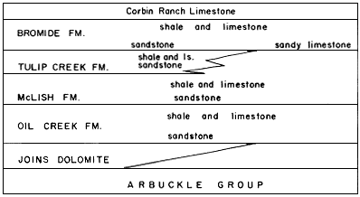
Repetition of rock types is recognizable in several systems in Oklahoma. Customarily the Simpson Group is thought of as consisting of four or five formations, each consisting of a basal sandstone, a middle shale, and an upper limestone, and each disconformably overlain by the succeeding formation. In fact, the sequence is not so regular nor is the existence of disconformities so certain. Ham (1955, Fig. 10) has shown that the Joins and Tulip Creek wedge out to the northeast and that the basal sandstones are not everywhere present. In subsurface, sections are known in which three sandstones occur in the McLish and two each in the Oil Creek and Bromide. It is probable that cyclicity in the Simpson is highly imperfect because of lateral facies changes (Fig. 1).Figure 1--Regional stratigraphy of the Simpson Group in Arbuckle Mountains (after Ham, 1955).
At the top of the section cyclical units are prominent in the Permian redbeds, primarily in the evaporite units (Jordan and Vosburg, 1963).
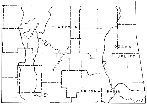
Well-developed cyclicity is so prominent in the Pennsylvanian System of the United States that in several areas, such as Missouri, Illinois, and Ohio, geologists divide the rocks into named cyclothems. Because Oklahoma has littIe platform area and much basinal area (Fig. 2), few cyclothems can be recognized in the state. Cyclicity however is apparent in the platform facies of the Desmoinesian and to a lesser extent in the Upper Pennsylvanian and Lower Permian (Gearyan).
Figure 2--Platform and basinal areas in part of northeastern Oklahoma.
Markers of cyclicity in the Desmoinesian disappear basinward. Of the principal platform coals, seven extend into the Arkoma Basin; no black fissile shale is persistent, but three caprock limestones have significant distribution in the basinal sediments (Fig. 3). Marmaton rocks in Oklahoma contain but one coal, known at two places, but one fissile black shale, and seven persistent limestones. One recognizable cyclothem is present in one county.
Figure 3--Extension of coals from platform into Arkoma Basin.
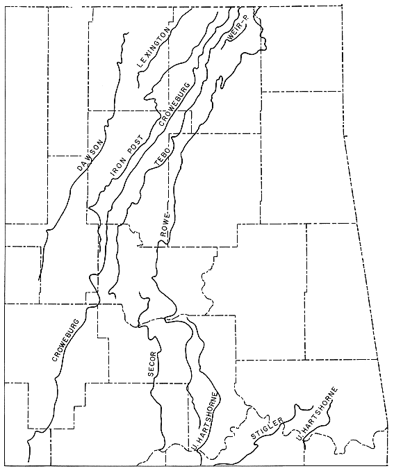
Table 1--Coal beds in the Krebs and Cabaniss Groups.
| Platform | Basin | |
|---|---|---|
| Cabaniss Group | Iron Post coal | |
| Bevier coal | ||
| Croweburg coal | Croweburg coal | |
| Mineral coal | ||
| Weir-Pittsburg coal | ||
| Krebs Group | Bluejacket coal | Secor coal |
| Drywood coal | Witteville coal | |
| Rowe coal | ||
| unnamed coal | Stigler coal | |
| unnamed coal | McAlester coal | |
| Riverton coal | U. Hartshorne coal | |
| unnamed coal | L. Hartshorne coal |
Sequences containing recognizable cyclical units together with coal and underclay are few.
| 1. | Spaniard Limestone | (in Savanna Fm.) |
| unnamed coal, local, thin | (in McAlester Fm.) | |
| underclay | ||
| 2. | Doneley Limestone | (in Savanna Fm.) |
| Rowe coal | ||
| underclay | ||
| 3. | caprock limestone, one locality | (in Savanna Fm.) |
| Drywood coal | ||
| underclay | ||
| 4. | Inola Limestone (lowest, fusulinid-bearing) | (in Boggy Fm.) |
| Secor? coal | ||
| underclay | ||
| 5. | black shale with ironstone concretions | (in Boggy Fm.) |
| lnola Limestone (upper, marginiferid-bearing) | ||
| coal | ||
| underclay | ||
| 6. | black shale with ironstone concretions | (in Senora Fm.) |
| Tiawah Limestone | ||
| black fissile shale | ||
| Tebo coal | ||
| underclay | ||
| 7. | Verdigris Limestone | (in Senora Fm.) |
| black fissile shale | ||
| shale, siltstone, sandstone | ||
| Croweburg coal | ||
| underclay | ||
| McNabb Limestone (underlime position, but marine) | ||
| 8. | Excello black shale | (in Senora Fm.) |
| Breezy Hill Limestone | ||
| marine shale | ||
| caprock limestone | ||
| Iron Post coal | ||
| underclay | ||
| 9. | Mine Creek Limestone | (in Marmaton Group) |
| Anna Shale, black fissile | ||
| caprock limestone | ||
| Lexington coal (two exposures) | ||
| underclay | ||
| underlime (marine) | ||
| 10. | caprock limestone | (in Seminole Fm.) |
| black fissile shale | ||
| Dawson coal | ||
| underclay | ||
| 11. | Hogshooter Limestone | (in Skiatook Group) |
| thin coal | ||
| local underclay |
No other sequence has significant distribution, and of the above only the Croweburg coal cycle occurs in as many as five counties; most occur in but one. The dominantly marine "cycles" of Osage and Pawnee Counties (Virgilian and above) are baffling in that many elements are local.
In Missourian rocks the Seminole Formation contains the Dawson coal and its overlying black fissile shale and concretionary caprock limestone. This unit is a cyclothem recognizable for 40 miles along strike. Above the Dawson coal cyclothem is no other unit which is of sufficient development or distribution to be considered a cyclothem. A few coal beds occur. The unnamed coal below the Hogshooter Limestone and the Cedar Bluff coal 11 to 40 feet below it are not in a recognizably cyclic sequence. The coal below the Paola Limestone and that below the Bowring Limestone are of extremely local distribution. In the Virgilian rocks a thin coal beneath the Turkey Run Limestone is known at but two localities. The Ralston coal, below the Brownville Limestone, is distributed across two counties.
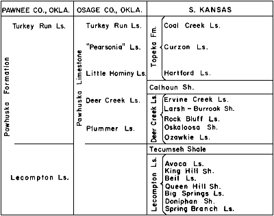
The unit which is in Oklahoma called the Pawhuska Formation is in part in Kansas incorporated into a megacyclothem (Moore, 1949, Fig. 31). The rocks of the basin margin of the platform in Oklahoma show no pattern which could be considered that of a megacyclothem; indeed, beyond repetition of fusulinid limestones they have no discernible cyclic pattern (Fig. 4).
Figure 4--Nomenclature of some equivalent Pennsylvanian rock units in southern Kansas and northern Oklahoma.
The Higginsville Limestone is nowhere in Oklahoma underlain by the Summit coal or its caprock, but grades southward from a 30-foot fusulinid limestone with black shale partings to a fossiliferous gray shale in a black-shale section.
The Hogshooter Limestone is discontinuous and no more than 6 inches thick at Sapulpa, 40 feet thick at Lost City, 14 feet thick at Ramona where it contains a coral reeflike buildup, 10 feet in Nowata County, and 4 feet of sandy limestone in Cedar Bluff, Montgomery County, Kansas.
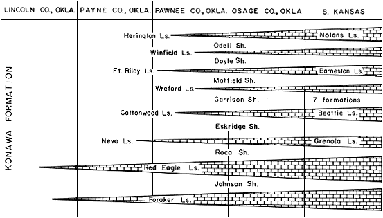
Basinward facies changes are rapid and profound. From Kansas southward the change in the rocks is reflected by the progressively simpler nomenclature. In the "Gearyan" the 19 formations of Kansas nomenclature are 14 in northern Oklahoma and one in central Oklahoma. The 26 Kansas Virgilian formations are 10 in northern Oklahoma and two in central Oklahoma. Many of these units have been considered cyclothems in Kansas (Fig. 5).
Figure 5--Upper Pennsylvanian rock units in north-central Oklahoma.
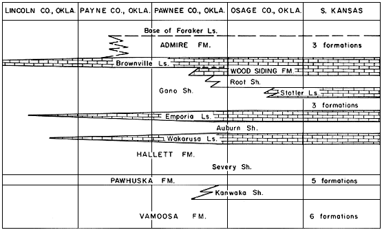
Figure 6--Lower Permian (?) rock units in north-central Oklahoma.
Ham, W. E., 1955, Geology of the Arbuckle Mountain region: Oklahoma Geol. Survey Guidebook 3, p. 161.
Jordan, Louise, and Vosburg, D. L., 1963, Permian salt and associated evaporites in the Anadarko Basin of the western Oklahoma-Texas Panhandle region: Oklahoma Geol. Survey Bull. 102, p. 1-76.
Moore, R. C., 1949, Divisions of the Pennsylvanian System in Kansas: Kansas Geol. Survey Bull. 83, p. 1-203. [available online]