![]()
Prev Page--Wells used in construction of cross sections
Appendices, continued
Appendix G--Road Logs
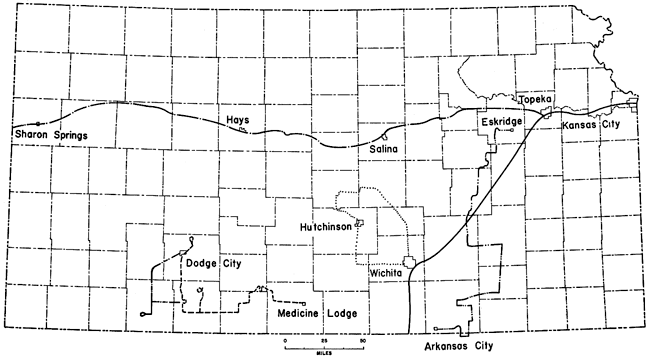
Road logs are available for various parts of Kansas, especially from the Kansas Geological Society. The following logs (Fig. 147), most of which were prepared for Kansas Geological Society field conferences, are in many ways general enough that they can be used along with a geologic map of the state as a guide for the traveler. Mr. C. K. Bayne, Dr. L. F. Dellwig, Dr. J. M. Jewett, Mr. W. S. Johns, Mr. W. D. Johnson Jr., Mr. Charles Lane, Mr. B. F. Latta, Dr. R. C. Moore, Mr. H. G. O'Connor, Mr. G. F. Stewart, and Dr. Ada Swineford helped prepare and check the logs.
Figure 147--Map of Kansas showing locations of selected road logs given in Appendix G.
Kansas Turnpike--Kansas City to South Haven
| Milepost | Tenths | |
|---|---|---|
| 0 | 18th Street Expressway, Kansas City, Kansas | |
| 0.2 | Drum Limestone underlain by Cherryvale Shale | |
| 1 | ||
| 0.2 | K-32 overpass | |
| 0.4 | Loess on Lane Shale on north | |
| 0.9 | Lane Shale-Iola Limestone on both sides of road | |
| 2 | ||
| 0.4 | Wyandotte Limestone on Lane Shale | |
| 0.7 | View of Kansas River | |
| 3 | Iola Limestone on both sides of road | |
| 0.1 | Drum Limestone on north | |
| 0.4 | Overpass | |
| 0.8 | Loess on both sides of road | |
| 0.9 | 61st Street underpass (Bridge 303) | |
| 4 | ||
| 0.4 | 65th Street underpass | |
| 0.5 | Pleistocene on Lane Shale | |
| 0.7 | Loess on both sides of road | |
| 5 | US-40 Interchange underpass (Bridge 300-A) | |
| 0.3 | Argentine Limestone on north | |
| 0.4 | 72nd Street underpass (Bridge 300) | |
| 0.5 | Farley Limestone on north | |
| 0.6 | Farley Limestone on both sides of road | |
| 0.7 | Kansas City Toll Station | |
| 6 | ||
| 0.1 | Overpass | |
| 0.7 | Loess on Argentine Limestone below road on north | |
| 7 | ||
| 0.1 | 86th Street underpass | |
| 0.2 | Pleistocene on Bonner Springs Shale | |
| 0.8 | Plattsburg Limestone on Bonner Springs Shale | |
| 8 | Vilas Shale to Stoner Limestone | |
| 0.1 | Bridge | |
| 0.2 | Bonner Springs Shale and Plattsburg Limestone | |
| 0.4 | Wyandotte Limestone to Plattsburg Limestone | |
| 0.6 | Overpass | |
| 0.7 | Farley Limestone on north | |
| 9 | ||
| 0.2 | Plattsburg Limestone to Stoner Limestone on both sides of road | |
| 0.3 | Pleistocene on South Bend Limestone (Stanton Formation) | |
| 10 | ||
| 0.1 | 110th Street (K-107) underpass (Bridge 294) | |
| 0.5 | Tonganoxie Sandstone on north | |
| 0.7 | Pleistocene on Tonganoxie Sandstone | |
| 0.8 | Tonganoxie Sandstone on both sides of road | |
| 11 | ||
| 0.1 | Tonganoxie Sandstone on north | |
| 0.2 | Overpass | |
| 0.3 | Pleistocene on both sides of road | |
| 0.5 | Tonganoxie Sandstone on both sides of road | |
| 0.8 | Riverview Road underpass (Bridge 291) | |
| 12 | South Bend Limestone in ditch on right | |
| 0.5 | Bonner Springs Interchange (Bridge 290-A) | |
| 0.7 | K-7 underpass (Bridge 290) | |
| 13 | ||
| 0.3 | Overpass | |
| 0.4 | Tonganoxie Sandstone on north | |
| 0.8 | South Bend Limestone to Wyandotte Limestone | |
| 14 | ||
| 0.3 | 142nd Street underpass (Bridge 288) | |
| 0.6 | Santa Fe Railroad overpass | |
| 0.7 | Wolf Creek overpass 15 | |
| 0.1 | Kansas Avenue underpass | |
| 0.2 | Bonner Springs Shale and Plattsburg Limestone | |
| 0.3 | Bonner Springs Shale and Plattsburg Limestone | |
| 0.9 | Tonganoxie Sandstone on both sides of road | |
| 16 | Tonganoxie Sandstone on north | |
| 0.3 | De Soto Road underpass (Bridge 284) | |
| 17 | ||
| 0.4 | Underpass (Bridge 283) | |
| 18 | ||
| 0.4 | Underpass (Bridge 282) | |
| 19 | ||
| 0.1 | Pleistocene on Tonganoxie Sandstone | |
| 0.3 | Underpass (Bridge 281) | |
| 20 | ||
| 0.2 | Underpass (Bridge 279) | |
| 0.7 | Stranger Creek overpass | |
| 21 | ||
| 0.7 | Stoner Limestone on both sides of road | |
| 0.8 | Tonganoxie Sandstone | |
| 22 | ||
| 0.3 | Glacial drift | |
| 0.6 | Underpass (Bridge 277) | |
| 0.7 | Stranger Formation on north | |
| 0.9 | Stranger Formation | |
| 23 | ||
| 0.2 | Stranger Formation | |
| 0.5 | Haskell Limestone Member on north | |
| 0.7 | Underpass (Bridge 276) | |
| 24 | Stranger Formation | |
| 0.6 | Pleistocene on Stranger Formation | |
| 0.8 | Eudora Road underpass (Bridge 275) | |
| 25 | Sandstone in Stranger Formation | |
| 0.1 | Massive sandstone in Stranger Formation | |
| 0.9 | Bridge | |
| 26 | ||
| 0.3 | Pleistocene on north | |
| 0.6 | Sandy shale in Stranger Formation | |
| 0.9 | Tonganoxie Sandstone | |
| 27 | ||
| 0.1 | Haskell Limestone on north | |
| 0.3 | Underpass | |
| 0.6 | Lawrence Service Area | |
| 28 | ||
| 0.2 | Underpass (Bridge 272) | |
| 0.7 | Pleistocene on both sides of road | |
| 29 | ||
| 0.1 | Stranger Formation | |
| 0.5 | Stranger Formation on both sides of road | |
| 30 | ||
| 0.3 | K-32 underpass (Bridge 270) | |
| 0.6 | Mud Creek overpass | |
| 0.9 | Union Pacific Railroad overpass | |
| 31 | River floodplain and low terraces | |
| 0.8 | Overpass | |
| 32 | ||
| 0.1 | Sand pit on south | |
| 0.8 | East Lawrence Interchange | |
| 33 | ||
| 0.3 | US-40 and US-24 overpass | |
| 0.5 | East end of Kansas River bridge | |
| 0.9 | West end of Kansas River bridge | |
| 34 | ||
| 0.2 | Union Pacific Railroad overpass | |
| 0.4 | Michigan Street underpass | |
| 0.7 | West Lawrence Interchange underpass (Bridge 261) | |
| 0.9 | Country Club Road underpass (Bridge 260) | |
| 35 | ||
| 0.1 | Oread Limestone scarp on south and ahead | |
| 0.9 | Lakeview Alternate Road underpass (Bridge 259) | |
| 36 | ||
| 0.5 | Road on Menoken terrace | |
| 0.9 | Baldwin Creek bridge | |
| 37 | ||
| 0.7 | Lawrence Shale and Oread Limestone on both sides of road. East end of exposure of Lawrence to Plattsmouth | |
| 38 | Harrison Well Road underpass | |
| 0.1 | Kereford Limestone | |
| 0.5 | Oread Limestone | |
| 0.7 | Plattsmouth Limestone | |
| 39 | ||
| 0.8 | Lecompton Limestone | |
| 40 | Kanwaka Road underpass (Bridge 256) | |
| 0.1 | Lecompton Limestone | |
| 0.3 | Lecompton Limestone on both sides of road | |
| 0.7 | Lecompton Limestone | |
| 41 | ||
| 0.5 | Tecumseh Shale and base of Deer Creek Limestone | |
| 0.7 | Sandstone in Tecumseh Shale | |
| 42 | ||
| 0.1 | Robert Steel Highway overpass | |
| 0.7 | Upper part Tecumseh Shale and Deer Creek Limestone | |
| 43 | ||
| 0.1 | Overpass | |
| 0.4 | Upper Tecumseh Shale and lower Deer Creek Limestone | |
| 0.9 | Deer Creek Limestone | |
| 44 | ||
| 0.1 | Ervine Creek Limestone | |
| 0.2 | Rock Bluff Limestone and Queen Hill Shale | |
| 45 | ||
| 0.1 | Lecompton Alternate Road underpass (Bridge 250) | |
| 46 | ||
| 0.1 | Topeka Limestone | |
| 0.4 | Topeka Limestone | |
| 0.6 | Big Springs Road underpass (Bridge 249) | |
| 0.8 | Calhoun Shale | |
| 47 | ||
| 0.1 | Bridge | |
| 0.2 | Upper Calhoun Shale and Topeka Limestone | |
| 0.6 | Pleistocene deposits on north | |
| 48 | ||
| 0.1 | Upper Calhoun Shale and Topeka Limestone | |
| 0.2 | US-40 overpass | |
| 0.7 | Upper Calhoun Shale and Topeka Limestone | |
| 49 | ||
| 0.2 | Miliken Road underpass (Bridge 246) | |
| 0.3 | Topeka Limestone | |
| 0.6 | Topeka Limestone | |
| 50 | Calhoun Shale | |
| 0.3 | Ozawkie Limestone to Ervine Creek Limestone | |
| 0.8 | Rock Bluff Limestone to Ervine Creek Limestone | |
| 51 | ||
| 0.1 | Calhoun Shale and Topeka Limestone | |
| 0.2 | Earl Hall Road underpass (Bridge 243) | |
| 0.4 | Ervine Creek Limestone | |
| 0.7 | Rock Bluff Limestone to Ervine Creek Limestone | |
| 52 | ||
| 0.1 | Deer Creek Limestone | |
| 0.3 | Calhoun Shale on both sides of road | |
| 0.4 | Sandstone in Calhoun Shale | |
| 0.7 | Topeka Limestone on both sides of road | |
| 0.8 | Tecumseh Road underpass (Bridge 242) | |
| 0.9 | Calhoun Shale and Hartford Limestone | |
| 53 | ||
| 0.3 | Ervine Creek Limestone | |
| 0.7 | Calhoun Shale and Topeka Limestone | |
| 0.8 | Topeka Service Area | |
| 54 | ||
| 0.3 | Croco Road underpass (Bridge 241) | |
| 0.9 | East Topeka Interchange underpass (Bridge 240) | |
| 55 | Topeka Limestone and upper Calhoun Shale | |
| 0.1 | Calhoun Shale | |
| 0.4 | Wittenberg Road underpass (Bridge 239) | |
| 56 | ||
| 0.1 | 29th Street underpass (Bridge 238) | |
| 0.2 | Topeka Limestone and Calhoun Shale | |
| 0.4 | Topeka Limestone | |
| 0.6 | Topeka Limestone | |
| 0.9 | Overpass | |
| 57 | ||
| 0.6 | Overpass | |
| 58 | ||
| 0.1 | Sandstone in White Cloud Shale | |
| 0.3 | Overpass | |
| 0.7 | Howard Limestone | |
| 59 | Nodaway coal and Church Limestone | |
| 0.2 | US-75 and Santa Fe and Missouri Pacific Railroad overpass | |
| 0.5 | South Topeka Interchange underpass (Bridge 230) | |
| 60 | ||
| 0.1 | White Cloud Shale | |
| 0.2 | Church Limestone | |
| 0.5 | Howard Limestone | |
| 0.7 | Glacial deposits | |
| 0.8 | Overpass (Bridge 228) | |
| 61 | Nodaway coal to Utopia Limestone | |
| 0.7 | Burlingame Road underpass (Bridge 227) | |
| 62 | ||
| 0.1 | White Cloud Shale | |
| 0.6 | White Cloud Shale | |
| 0.8 | Burlingame Limestone on both sides of road | |
| 63 | Pauline Road overpass (Bridge 226) | |
| 0.1 | Burlingame Limestone | |
| 0.4 | Burlingame Limestone | |
| 0.8 | Happy Hollow Limestone to Rulo Limestone | |
| 64 | ||
| 0.1 | Clark Road underpass (Bridge 224) | |
| 0.3 | White Cloud Shale | |
| 0.9 | Happy Hollow Limestone? | |
| 65 | ||
| 0.3 | Wanamaker Road underpass (Bridge 223) | |
| 66 | ||
| 0.5 | Burlingame Limestone | |
| 67 | ||
| 0.1 | Auburn Road underpass (Bridge 220) | |
| 0.8 | Burlingame Limestone | |
| 68 | ||
| 0.3 | Wakarusa Road underpass (Bridge 218) | |
| 0.8 | Wakarusa Creek overpass (Bridge 217) | |
| 69 | ||
| 0.2 | Burlingame Limestone and Soldier Creek Shale | |
| 0.5 | Auburn-Osage Road underpass (Bridge 216) | |
| 0.6 | Limestone in Soldier Creek Shale | |
| 0.7 | Limestone in Soldier Creek Shale | |
| 70 | ||
| 0.6 | Poor exposure of Reading Limestone | |
| 71 | ||
| 0.1 | Elmont Limestone | |
| 0.5 | Elmont Limestone and Willard Shale | |
| 0.8 | Willard Shale to Maple Hill Limestone | |
| 72 | Tarkio Limestone to Maple Hill Limestone | |
| 0.4 | Sandstone in Pillsbury Shale | |
| 0.5 | Sandstone in Pillsbury Shale (Bridge 215) | |
| 0.8 | Maple Hill Limestone | |
| 0.9 | Tarkio Limestone | |
| 73 | ||
| 0.1 | Tarkio Limestone | |
| 0.9 | Prairie Center Road underpass (Bridge 213) | |
| 75 | ||
| 0.6 | Tabor Road underpass (Bridge 211) | |
| 76 | ||
| 0.5 | Switzler Road underpass (Bridge 210) | |
| 0.7 | Sandstone in Pillsbury Shale | |
| 77 | Sandstone in Pillsbury Shale | |
| 0.7 | Underpass (Bridge 209) | |
| 0.9 | Dover Limestone | |
| 78 | ||
| 0.8 | Dover Limestone overlying Pillsbury Shale | |
| 79 | ||
| 0.5 | Santa Fe Railroad overpass (Bridge 207) | |
| 0.6 | Dragoon Creek bridge | |
| 0.9 | Dover Limestone and underlying shale | |
| 80 | ||
| 0.1 | Underpass (Bridge 205) | |
| 0.2 | Dover Limestone | |
| 81 | ||
| 0.1 | K-31 underpass (Bridge 204) | |
| 0.3 | Soldier Creek bridge | |
| 0.7 | Underpass (Bridge 202) | |
| 82 | ||
| 0.3 | Underpass (Bridge 201) | |
| 83 | ||
| 0.3 | Pillsbury Shale and Dover Limestone | |
| 0.5 | Underpass (Bridge 200); sandstone in Pillsbury Shale | |
| 0.7 | Sandstone In Pillsbury Shale overlain by Dover Limestone | |
| 84 | ||
| 0.9 | Harveyville Road underpass (Bridge 197) | |
| 86 | ||
| 0.1 | Underpass (Bridge 196) | |
| 88 | ||
| 0.1 | Underpass (Bridge 194) | |
| 0.7 | Marais des Cygnes River bridge; Maple Hill Limestone under bridge | |
| 89 | Pillsbury Shale to Jim Creek Limestone | |
| 0.6 | US-56 underpass (Bridge 192) | |
| 0.8 | Admire Interchange (Bridge 192-A) | |
| 90 | ||
| 0.4 | French Creek Shale and Grayhorse Limestone | |
| 91 | Underpass (Bridge 190) | |
| 0.4 | Missouri Pacific Railroad overpass | |
| 0.7 | Dover Limestone | |
| 0.9 | Underpass (Bridge 188) | |
| 92 | ||
| 0.5 | Hundred and Fortytwo Mile Creek bridge | |
| 0.7 | Dover Limestone and Pillsbury Shale | |
| 93 | ||
| 0.2 | Underpass (Bridge 184) | |
| 0.5 | Hill Creek bridge | |
| 0.7 | Dry Shale and Grandhaven Limestone | |
| 94 | ||
| 0.5 | Underpass (Bridge 182) | |
| 95 | ||
| 0.2 | Nebraska City Limestone and underlying beds | |
| 0.9 | Brownville Limestone and Grayhorse Limestone | |
| 96 | ||
| 0.3 | K-99 underpass (Bridge 178) | |
| 97 | ||
| 0.1 | Underpass (Bridge 177) | |
| 0.7 | Falls City Limestone? | |
| 98 | ||
| 0.4 | Underpass (Bridge 176) | |
| 99 | ||
| 0.1 | Falls City Limestone | |
| 0.6 | Underpass (Bridge 174) 100 | |
| 0.9 | Dows Creek bridge | |
| 101 | ||
| 0.7 | K-99 underpass (Bridge 170) | |
| 103 | ||
| 0.7 | K-99 underpass (Bridge 168) | |
| 104 | ||
| 0.4 | Underpass (Bridge 167) | |
| 105 | Emporia Service Area | |
| 0.5 | Underpass (Bridge 166) 106 | |
| 0.3 | Allen Creek bridge | |
| 0.5 | Missouri, Kansas, and Texas Railroad overpass (Bridge 163) | |
| 0.7 | Troublesome Creek bridge | |
| 0.9 | Underpass (Bridge 161) 107 | |
| 0.5 | Neosho River bridge | |
| 0.8 | Nebraska City Limestone and adjacent beds | |
| 108 | ||
| 0.2 | Underpass (Bridge 159) | |
| 0.5 | Americus Road underpass (Bridge 158) | |
| 109 | ||
| 0.3 | Underpass (Bridge 157) | |
| 0.7 | Emporia Interchange underpass (Bridge 156) | |
| 0.9 | US-50 overpass (Bridge 155) | |
| 110 | ||
| 0.5 | Overpass | |
| 0.8 | Santa Fe Railroad overpass | |
| 112 | Cottonwood River bridge | |
| 113 | ||
| 0.5 | Bridge | |
| 0.9 | Wood Siding Formation | |
| 114 | ||
| 0.1 | Bridge 146 | |
| 0.2 | Brownville Limestone | |
| 116 | ||
| 0.2 | Pipe Township Road (Bridge 144) | |
| 0.4 | Hamlin Shale | |
| 0.7 | Hamlin Shale | |
| 117 | ||
| 0.1 | Americus Limestone | |
| 0.2 | Hughes Creek Shale | |
| 0.5 | Red Eagle Limestone | |
| 0.7 | Grenola Limestone | |
| 118 | ||
| 0.1 | Red Eagle Limestone | |
| 0.2 | Johnson Shale | |
| 0.4 | Johnson Shale | |
| 0.7 | Johnson Shale | |
| 0.8 | Center Township Road (Bridge 140) | |
| 119 | ||
| 0.1 | Upper Johnson Shale and lower Red Eagle Limestone | |
| 0.2 | Howe Limestone | |
| 0.3 | Lower Grenola Limestone | |
| 0.8 | Burr Limestone | |
| 0.9 | Legion Shale and Sallyards Limestone | |
| 120 | Roca Shale | |
| 0.2 | Red Eagle Limestone | |
| 0.7 | Johnson Shale to Grenola Limestone | |
| 121 | ||
| 0.1 | Neva Limestone | |
| 0.5 | Cottonwood Limestone overlain by Florena Shale | |
| 0.9 | Easly Creek Shale overlain by Crouse Limestone | |
| 122 | Tea Pot Mound Road underpass (Bridge 138); Crouse Limestone overlain by Blue Rapids Shale | |
| 0.2 | Blue Rapids Shale | |
| 0.6 | Speiser Shale and Threemile Limestone | |
| 0.9 | Funston Limestone and underlying Blue Rapids Shale | |
| 123 | ||
| 0.1 | Crouse Limestone | |
| 0.5 | Crouse Limestone | |
| 0.9 | Bader Limestone and overlying Easly Creek Shale | |
| 124 | ||
| 0.3 | Bader Limestone | |
| 0.7 | Bader Limestone | |
| 0.9 | Blue Rapids Shale to Speiser Shale on east side of road | |
| 125 | ||
| 0.2 | Speiser Shale and Threemlle Limestone | |
| 0.5 | Threemile Limestone and Havensville Shale | |
| 0.7 | Havensville Shale and Schroyer Limestone | |
| 0.8 | Bazaar cattle crossing (Bridge 137) | |
| 126 | ||
| 0.1 | Havensville Shale and Schroyer Limestone | |
| 0.4 | Havensville Shale | |
| 0.6 | Threemile Limestone | |
| 0.8 | Havensville Shale and Schroyer Limestone | |
| 127 | ||
| 0.7 | Wymore Shale and overlying Kinney Limestone | |
| 128 | ||
| 0.4 | Schroyer Limestone | |
| 0.9 | Schroyer Limestone | |
| 129 | Schroyer Limestone | |
| 0.6 | Kinney Limestone | |
| 130 | Florence Limestone | |
| 0.2 | Kinney Limestone | |
| 0.6 | Threemile Limestone and Speiser Shale | |
| 131 | Funston Limestone | |
| 0.3 | Funston Limestone and Blue Rapids Shale | |
| 0.4 | Sharps Creek bridge | |
| 0.7 | Funston Limestone | |
| 132 | Speiser Shale and overlying Threemile Limestone | |
| 0.4 | Matfield Green cattle crossing; Wymore Shale | |
| 0.6 | Schroyer Limestone | |
| 0.8 | Threemile Limestone and Speiser Shale | |
| 133 | ||
| 0.2 | Funston Limestone and Speiser Shale | |
| 0.4 | Funston Limestone and Speiser Shale | |
| 134 | ||
| 0.4 | Shaw Creek Road | |
| 0.9 | Little Cedar Creek Road underpass (Bridge 133) | |
| 135 | Blue Rapids Shale | |
| 0.3 | Overpass | |
| 0.5 | Funston Limestone and Speiser Shale | |
| 0.8 | Wreford Limestone | |
| 136 | ||
| 0.1 | Speiser Shale and Funston Limestone | |
| 0.3 | Funston Limestone | |
| 0.4 | Crouse Limestone | |
| 0.6 | Overpass | |
| 137 | ||
| 0.1 | Underpass (Bridge 130) | |
| 0.3 | Blue Rapids Shale and Funston Limestone | |
| 0.7 | Speiser Shale and Threemile Limestone | |
| 138 | ||
| 0.2 | Kinney Limestone | |
| 0.3 | Florence Limestone and underlying Matfield Shale | |
| 0.7 | Florence Limestone | |
| 0.9 | Florence Limestone | |
| 139 | ||
| 0.7 | Matfield Green Service Area | |
| 140 | ||
| 0.8 | Quarry in Fort Riley Limestone on west | |
| 141 | ||
| 0.3 | Lower part of the Doyle Shale | |
| 142 | ||
| 0.6 | Santa Fe Railroad overpass | |
| 144 | ||
| 0.3 | K-13 underpass (Cassoday) | |
| 0.8 | Underpass | |
| 146 | ||
| 0.1 | Harsh Road underpass | |
| 147 | ||
| 0.4 | Oakdale Road underpass (Bridge 122) | |
| 148 | ||
| 0.1 | Towanda Limestone | |
| 0.8 | Hursh Road underpass (Bridge 121) | |
| 149 | ||
| 0.5 | Towanda Limestone | |
| 150 | ||
| 0.1 | Underpass (Bridge 120) | |
| 0.5 | Fort Riley Limestone | |
| 151 | ||
| 0.4 | Fort Riley Limestone | |
| 0.5 | Fort Riley Limestone | |
| 152 | Fort Riley Limestone | |
| 0.1 | Ellis Road underpass (Bridge 119) | |
| 0.4 | Fort Riley Limestone | |
| 0.6 | Benson Road underpass (Bridge 118) | |
| 153 | Upper part of Fort Riley Limestone | |
| 0.3 | Upper part of Fort Riley Limestone | |
| 0.6 | Quarry in Fort Riley Limestone on west | |
| 154 | ||
| 0.3 | Fort Riley Limestone | |
| 0.6 | Holmesville Shale and Towanda Limestone | |
| 0.9 | Fort Riley Limestone | |
| 155 | ||
| 0.1 | Bridge | |
| 0.5 | Chelsea Road underpass (Bridge 117) | |
| 0.9 | Bridge | |
| 156 | ||
| 0.5 | Towanda Limestone | |
| 157 | ||
| 0.5 | Putnam Road underpass (Bridge 114) | |
| 161 | ||
| 0.2 | Upper part of Doyle Shale | |
| 0.3 | US-77 underpass (Bridge 112) | |
| 0.5 | Towanda Limestone | |
| 0.7 | Bridge | |
| 162 | ||
| 0.3 | Bridge | |
| 0.8 | Winfield Limestone | |
| 163 | ||
| 0.1 | Winfield Limestone | |
| 0.5 | Winfield Limestone | |
| 164 | ||
| 0.1 | Oil Hill Road | |
| 0.4 | Bridge | |
| 165 | Cresswell Limestone | |
| 0.3 | Bridge | |
| 0.6 | El Dorado Township Road underpass (Bridge 106) | |
| 166 | ||
| 0.1 | El Dorado Interchange underpass (Bridge 104) | |
| 0.3 | K-196 underpass | |
| 0.9 | Underpass (Bridge 102) | |
| 168 | ||
| 0.2 | Florence Limestone | |
| 0.4 | Kechi Road underpass (Bridge 100) | |
| 169 | ||
| 0.5 | Cresswell Limestone | |
| 0.8 | Cresswell Limestone | |
| 0.9 | Underpass (Bridge 98) | |
| 171 | ||
| 0.1 | Ohio Street underpass (Bridge 97) | |
| 0.7 | Cresswell Limestone | |
| 0.8 | Towanda Service Area | |
| 172 | Cresswell Limestone | |
| 0.2 | Cresswell Limestone | |
| 0.7 | Lower part of Winfield Limestone and Gage Shale | |
| 0.8 | Towanda Road underpass (Bridge 95) | |
| 173 | ||
| 0.2 | Whitewater River bridge | |
| 0.9 | Underpass (Bridge 92) | |
| 174 | ||
| 0.5 | Winfield Limestone | |
| 175 | ||
| 0.1 | Odell Shale | |
| 0.4 | Santa Fe Lake Road underpass (Bridge 90) | |
| 0.7 | Herington Limestone | |
| 176 | ||
| 0.6 | 29th Street underpass (Bridge 88) | |
| 177 | ||
| 0.4 | Indianola Road underpass (Bridge 87) | |
| 178 | ||
| 0.3 | Bridge | |
| 179 | ||
| 0.2 | 21st Street underpass | |
| 0.9 | 162nd Street underpass (Bridge 84) | |
| 180 | ||
| 0.7 | Bridge | |
| 181 | ||
| 0.1 | 160th Street underpass (Bridge 82) | |
| 0.2 | Main Street underpass (Bridge 81); Wellington Shale | |
| 0.3 | 13th Street underpass; Wellington Shale | |
| 0.4 | Wellington Shale | |
| 182 | ||
| 0.2 | 159th Street underpass (Bridge 79) | |
| 183 | ||
| 0.2 | Bridge | |
| 0.4 | 143rd Street underpass (Bridge 76) | |
| 184 | ||
| 0.6 | Wellington Shale | |
| 0.7 | 127th Street underpass; Wellington Shale | |
| 0.8 | US-54 and Kellogg Road underpass (Bridge 74) | |
| 0.9 | Wellington Shale | |
| 185 | ||
| 0.8 | Bridge | |
| 186 | ||
| 0.8 | Webb Road underpass (Bridge 72) | |
| 187 | ||
| 0.1 | East Wichita Interchange underpass (Bridge 71) | |
| 0.9 | Bridge | |
| 188 | ||
| 0.4 | Bridge | |
| 189 | Wellington Shale | |
| 0.3 | Bridge | |
| 0.9 | Bridge | |
| 190 | ||
| 0.6 | Bridge | |
| 0.8 | Fees Avenue underpass (Bridge 61) | |
| 191 | ||
| 0.3 | Hamilton Road underpass (Bridge 60) | |
| 0.9 | K-15 Interchange underpass (Bridge 59) | |
| 192 | ||
| 0.1 | K-15 overpass | |
| 0.2 | Santa Fe Railroad overpass | |
| 0.3 | Arkansas River bridge | |
| 0.5 | Bridge 193 | |
| 0.8 | Bridge | |
| 194 | ||
| 0.2 | Bridge | |
| 0.6 | South Wichita Interchange overpass | |
| 195 | ||
| 0.2 | Bridge | |
| 196 | ||
| 0.2 | Bridge | |
| 0.6 | Bridge | |
| 197 | ||
| 0.2 | Haysville Road underpass (Bridge 45) | |
| 198 | ||
| 0.2 | Derby Road underpass (Bridge 43) | |
| 199 | ||
| 0.2 | Underpass (Bridge 42) | |
| 200 | ||
| 0.2 | Waco Road underpass (Bridge 41) | |
| 201 | ||
| 0.2 | Clearwater Road underpass (Bridge 40) | |
| 202 | ||
| 0.1 | Bridge | |
| 0.3 | Underpass (Bridge 39) | |
| 203 | ||
| 0.3 | Bridge | |
| 204 | ||
| 0.1 | Underpass (Bridge 37) | |
| 205 | ||
| 0.1 | Underpass (Bridge 36) | |
| 206 | ||
| 0.1 | Underpass (Bridge 35) | |
| 0.7 | Terrace deposits | |
| 207 | ||
| 0.1 | Underpass (Bridge 34) | |
| 0.6 | Bridge | |
| 208 | ||
| 0.1 | Underpass (Bridge 32) | |
| 209 | ||
| 0.1 | Bridge | |
| 0.6 | Sand dunes | |
| 0.8 | Ninnescah River bridge | |
| 210 | ||
| 0.1 | Underpass (Bridge 30) | |
| 0.3 | Bridge | |
| 211 | Wellington Service Area | |
| 0.1 | Underpass (Bridge 28) | |
| 0.6 | Wellington Shale | |
| 0.9 | Bridge | |
| 213 | ||
| 0.3 | Underpass (Bridge 26) | |
| 214 | ||
| 0.4 | Underpass (Bridge 25) | |
| 215 | ||
| 0.5 | Underpass (Bridge 24) | |
| 216 | ||
| 0.5 | Underpass (Bridge 23) | |
| 217 | ||
| 0.3 | Wellington Shale | |
| 0.5 | South Haven Toll Station (Bridge 22) | |
| 0.8 | Wellington Shale | |
| 218 | ||
| 0.2 | Bridge | |
| 0.5 | Bridge | |
| 219 | ||
| 0.5 | Underpass (Bridge 19) | |
| 220 | ||
| 0.5 | Underpass (Bridge 18) | |
| 221 | ||
| 0.6 | Bridge | |
| 222 | ||
| 0.4 | Wellington Shale | |
| 0.5 | Underpass (Bridge 16) | |
| 223 | ||
| 0.5 | Underpass (Bridge 15) | |
| 225 | ||
| 0.5 | Underpass (Bridge 13) | |
| 226 | ||
| 0.5 | Underpass (Bridge 12) | |
| 227 | ||
| 0.2 | Wellington Shale | |
| 228 | ||
| 0.5 | Underpass (Bridge 10) | |
| 0.9 | Wellington Shale | |
| 230 | ||
| 0.5 | Underpass (Bridge 8) | |
| 0.6 | Wellington Shale | |
| 231 | ||
| 0.4 | Bridge | |
| 232 | ||
| 0.4 | Bridge | |
| 0.9 | Wellington Shale | |
| 233 | ||
| 0.4 | Wellington Shale | |
| 0.6 | Underpass (Bridge 4) | |
| 234 | ||
| 0.6 | Underpass (Bridge 3) | |
| 235 | ||
| 0.6 | Underpass (Bridge 2) | |
| 0.7 | Wellington Shale | |
| 0.9 | Wellington Shale | |
| 236 | ||
| 0.7 | Oklahoma state line and underpass (Bridge 1) |
I-70 and US-40-Topeka to Sharon Springs
| Cumulative mileage |
Mileage | |
|---|---|---|
| 0.0 | 0.0 | South Topeka Interchange, Kansas Turnpike, and I-470 and US-75 bypass |
| 0.9 | 0.9 | Burlingame overpass; Howard Limestone and Nodaway coal |
| 2.5 | 1.6 | Gage underpass |
| 2.8 | 0.3 | White Cloud Shale |
| 3.3 | 0.5 | 29th Street underpass |
| 4.4 | 1.1 | Sandstone in White Cloud Shale |
| 4.6 | 0.2 | 21st Street underpass |
| 5.7 | 1.1 | Wanamaker Road overpass |
| 6.1 | 0.4 | Bern Limestone underlain by Scranton Shale |
| 7.2 | 1.1 | I-70 and US-40 overpass |
| 7.8 | 0.6 | Silver Lake Shale overlain by Burlingame Limestone |
| 8.8 | 1.0 | Underpass |
| 9.1 | 0.3 | Auburn Road underpass |
| 9.4 | 0.3 | Auburn Shale and Emporia Limestone |
| 10.0 | 0.6 | Emporia Limestone |
| 10.4 | 0.4 | Bern Limestone overlying Scranton Shale |
| 10.8 | 0.4 | Blacksmith Creek bridge |
| 11.0 | 0.2 | Scranton Shale and overlying Bern Limestone |
| 11.4 | 0.4 | Mission Creek bridge |
| 12.2 | 0.8 | Valencia Road underpass |
| 12.7 | 0.5 | Auburn Shale |
| 13.1 | 0.4 | Zeandale Limestone and Willard Shale (below) |
| 13.4 | 0.3 | Tarkio Limestone on both sides of road |
| 13.7 | 0.3 | Tarkio Limestone underlain by Willard Shale |
| 14.0 | 0.3 | Upper part of Emporia Formation |
| 14.1 | 0.1 | Emporia Limestone and Auburn Shale on left |
| 14.5 | 0.4 | West Union Road underpass |
| 14.8 | 0.3 | Willard Shale overlain by Tarkio Limestone |
| 15.5 | 0.7 | Buffalo Mound ahead on skyline |
| 16.0 | 0.5 | Willard-Dover Road underpass |
| 16.5 | 0.5 | Zeandale Limestone |
| 16.7 | 0.2 | Tarkio Limestone |
| 17.1 | 0.4 | Dover Limestone on north side of road |
| 17.3 | 0.2 | Dover Limestone underlain by Pillsbury Shale |
| 17.6 | 0.3 | Dover Limestone on both sides of road |
| 17.8 | 0.2 | Dover Limestone on both sides of road |
| 19.3 | 1.5 | Stotler Limestone |
| 19.9 | 0.6 | Stotler Limestone |
| 20.0 | 0.1 | Stotler Limestone and Pillsbury Shale on both sides of road |
| 20.4 | 0.4 | Bridge |
| 21.1 | 0.7 | K 30 underpass |
| 21.7 | 0.6 | Brownville Limestone (Pennsylvanian) overlain by Towle Shale (Permian) |
| 22.9 | 1.2 | Falls City Limestone overlain by West Branch Shale |
| 23.8 | 0.9 | Aspinwall Limestone |
| 24.1 | 0.3 | Vera Road underpass |
| 26.9 | 2.8 | Bridge |
| 27.5 | 0.6 | Roadside park |
| 28.3 | 0.8 | Hughes Creek Shale exposure with Long Creek Limestone at top |
| 28.5 | 0.2 | Hamlin Shale overlain by Foraker Limestone |
| 28.7 | 0.2 | Mill Creek bridge |
| 29.0 | 0.3 | Rock Island Railroad overpass |
| 29.2 | 0.2 | K-138 overpass |
| 29.6 | 0.4 | Bridge |
| 29.9 | 0.3 | Chert gravel hills (buried Pleistocene valley) on north |
| 31.8 | 1.9 | Bridge |
| 32.0 | 0.2 | K-185 underpass |
| 33.3 | 1.3 | Rock Island Railroad overpass |
| 33.5 | 0.2 | Bridge |
| 34.0 | 0.5 | Grenola Limestone to Cottonwood Limestone |
| 34.3 | 0.3 | Cottonwood Limestone |
| 34.5 | 0.2 | K-99 overpass; Florena Shale and Morrill Limestone |
| 35.4 | 0.9 | Bader Limestone |
| 35.9 | 0.5 | Threemile Limestone and underlying Speiser Shale |
| 36.3 | 0.4 | Wreford Limestone and underlying Speiser Shale |
| 36.5 | 0.2 | Funston Limestone on south side of road |
| 36.8 | 0.3 | Funston Limestone, Blue Rapids Shale, Crouse Limestone, and Easly Creek Shale (below) |
| 37.1 | 0.3 | Crouse Limestone on both sides of road |
| 37.3 | 0.2 | Bader Limestone |
| 37.5 | 0.2 | Beattie Limestone |
| 37.8 | 0.3 | Cottonwood Limestone |
| 38.3 | 0.5 | Bridge |
| 40.3 | 2.0 | Funston Limestone on south |
| 40.5 | 0.2 | Wreford Limestone |
| 40.9 | 0.4 | Schroyer Limestone |
| 42.3 | 1.4 | Limestone in Havensville Shale above Threemile Limestone |
| 42.9 | 0.6 | Bader Limestone |
| 43.6 | 0.7 | Eskridge Shale |
| 43.9 | 0.3 | Bridge; Neva Limestone |
| 45.0 | 1.1 | Eskridge Shale overlain by Beattie Limestone |
| 45.6 | 0.6 | Eskridge Shale to Bader Limestone |
| 45.8 | 0.2 | Bridge |
| 46.0 | 0.2 | Bader Limestone |
| 46.3 | 0.3 | Funston Limestone, Speiser Shale, and lower part of Wreford Limestone |
| 46.5 | 0.2 | Wreford Limestone |
| 46.7 | 0.2 | Schroyer Limestone |
| 46.9 | 0.2 | Schroyer Limestone |
| 47.4 | 0.5 | Florence Limestone and underlying Matfield Shale |
| 47.8 | 0.4 | Florence Limestone |
| 48.1 | 0.3 | K-13 overpass |
| 48.3 | 0.2 | Florence Limestone and Matfield Shale |
| 49.0 | 0.7 | Florence Limestone |
| 49.7 | 0.7 | Wreford Limestone |
| 50.4 | 0.7 | Florence Limestone |
| 51.9 | 1.5 | Wreford Limestone |
| 52.6 | 0.7 | Kinney Limestone |
| 53.0 | 0.4 | McDowell Creek |
| 54.5 | 1.5 | Florence Limestone and Matfield Shale |
| 55.2 | 0.7 | Ft. Riley Limestone |
| 56.2 | 1.0 | Florence Limestone |
| 57.1 | 0.9 | Kinney Limestone? |
| 57.7 | 0.6 | Clark Creek |
| 58.8 | 1.1 | Ft. Riley Military Reservation; Wreford Limestone |
| 59.1 | 0.3 | Funston Limestone |
| 60.4 | 1.3 | Marshall Field underpass |
| 62.2 | 1.8 | Florence Limestone and underlying units |
| 62.7 | 0.5 | Smoky Hill River |
| 63.5 | 0.8 | Junction City; K-207 overpass |
| 64.9 | 1.4 | US-77 overpass |
| 65.9 | 1.0 | Roadside park |
| 69.5 | 3.6 | Ft. Riley-Milford Road bridge |
| 70.6 | 1.1 | Dickinson County |
| 73.2 | 2.6 | K 206 overpass |
| 73.5 | 0.3 | Winfield Limestone |
| 77.6 | 4.1 | Nolans Limestone |
| 78.5 | 0.9 | K-43 overpass |
| 81.9 | 3.4 | Buckeye Road underpass |
| 83.4 | 1.5 | Wellington Shale (poorly exposed) |
| 84.4 | 1.0 | K-15 overpass |
| 87.1 | 2.7 | Talmage underpass |
| 93.3 | 6.2 | K 221 underpass |
| 93.8 | 0.5 | Saline County |
| 94.6 | 0.8 | Roadside park |
| 99.9 | 5.3 | New Cambria (K 220) underpass |
| 100.4 | 0.5 | Dakota Group (poorly exposed) |
| 103.7 | 3.3 | Dakota rocks poorly exposed |
| 106.4 | 2.7 | Camp Webster Road |
| 107.5 | 1.1 | US-81 overpass, turn left (south) on US-40 and 81 |
| 109.8 | 2.3 | Turn right on US-40 |
| 111.3 | 1.5 | US-81 bypass |
| 118.0 | 6.7 | Bavaria |
| 124.2 | 6.2 | Brookville |
| 128.5 | 4.3 | Ellsworth County |
| 129.8 | 1.3 | Sandstone in Dakota at left (south) capping small hill |
| 131.1 | 1.3 | K-141 intersection |
| 131.3 | 0.2 | Dakota sandstone on both sides of road |
| 134.5 | 3.2 | Carneiro |
| 135.6 | 1.1 | Dakota sandstone on both sides of road |
| 141.2 | 5.6 | K III intersection |
| 144.8 | 3.6 | K-45 intersection |
| 145.3 | 0.5 | K-14 intersection |
| 145.5 | 0.2 | Ellsworth |
| 151.1 | 5.6 | Cross-bedded sandstone in the Dakota Group |
| 160.8 | 9.7 | Wilson |
| 161.8 | 1.0 | Russell County |
| 167.5 | 5.7 | Dorrance |
| 174.3 | 6.8 | Greenhorn Limestone (poor exposure) |
| 183.0 | 8.7 | Russell |
| 192.6 | 9.6 | Gorham |
| 193.7 | 1.1 | Ellis County |
| 195.8 | 2.1 | Walker |
| 199.7 | 3.9 | Victoria |
| 208.8 | 9.1 | Stay left on bypass US-40 |
| 209.0 | 0.2 | Hays |
| 210.5 | 1.5 | Roadside park |
| 210.8 | 0.3 | US-183 intersection |
| 211.0 | 0.2 | Old Fort Hays |
| 212.8 | 1.8 | Business US-40 intersection |
| 217.1 | 4.3 | Upper part of Carlile Shale overlain by Fort Hays Limestone |
| 222.8 | 5.7 | Abandoned quarry in Fort Hays Limestone (south side) |
| 223.0 | 0.2 | Fort Hays Limestone on left (south) |
| 224.4 | 1.4 | Ellis |
| 226.7 | 2.3 | Trego County |
| 229.9 | 3.2 | I-70; keep left |
| 231.0 | 1.1 | Ogallala Formation in road cut |
| 231.5 | 0.5 | Ogallala Formation in road cut |
| 231.8 | 0.3 | K-147 overpass |
| 234.5 | 2.7 | Rest area north side of road |
| 235.4 | 0.9 | Rest area south side of road |
| 239.2 | 3.8 | US-283 north |
| 240.2 | 1.0 | US-283 south |
| 252.4 | 12.2 | Veda underpass |
| 257.4 | 5.0 | K-198 overpass |
| 259.5 | 2.1 | Gove County |
| 265.2 | 5.7 | K-212 overpass |
| 273.0 | 7.8 | K-211 overpass |
| 276.2 | 3.2 | Rest area |
| 279.1 | 2.9 | K-23 |
| 279.5 | 0.4 | US-40 keep right |
| 287.4 | 7.9 | Grinnell |
| 297.5 | 10.1 | Logan County |
| 297.7 | 0.2 | Roadside park |
| 299.4 | 1.7 | Oakley |
| 299.6 | 0.2 | US-383 and US-83 |
| 308.3 | 8.7 | Monument |
| 310.8 | 2.5 | K-25 (north) |
| 318.2 | 7.4 | K-25 (south) |
| 321.7 | 3.5 | Winona |
| 328.1 | 6.4 | Pierre Shale overlain by Pleistocene deposits |
| 328.6 | 0.5 | North Fork Smoky Hill River |
| 330.1 | 1.5 | McAllaster Buttes, Pierre Shale exposures |
| 331.0 | 0.9 | McAllaster |
| 335.4 | 4.4 | Turtle Creek |
| 337.2 | 1.8 | Wallace County |
| 339.7 | 2.5 | Fort Wallace museum and park |
| 340.2 | 0.5 | Wallace |
| 349.8 | 9.6 | Sharon Springs |
| 350.0 | 0.2 | K-27 (north) |
| 350.1 | 0.1 | K-27 (south) |
| 362.4 | 12.3 | Weskan |
| 366.9 | 4.5 | Colorado state line |
US-166, K-38, US-160, K-99, US-54, US-56, K-4, and county roads, Arkansas City to Eskridge (from Kansas Geological Society 24th Field Conference Guidebook)
| Cumulative mileage |
Mileage | |
|---|---|---|
| 0.0 | 0.0 | Arkansas City, east side of town on south side US-166 (Madison Avenue) just east of Santa Fe Railroad underpass |
| 0.1 | 0.1 | Walnut River |
| 0.5 | 0.4 | Winfield Limestone in road cut |
| 0.8 | 0.3 | Loess overlying Odell Shale |
| 3.2 | 2.4 | Winfield Limestone capping hill on left. Leave US-166; go straight ahead, curve right on old US-166 |
| 3.4 | 0.2 | Intermediate (Illinoisian) terrace |
| 3.8 | 0.4 | Lower (Wisconsinan) terrace |
| 4.8 | 1.0 | Winfield Limestone overlain by loess |
| 5.6 | 0.8 | Winfield Limestone scarp |
| 6.9 | 1.3 | Poor exposure of Ft. Riley Limestone |
| 7.2 | 0.3 | Silverdale Road |
| 7.3 | 0.1 | Ft. Riley Limestone |
| 7.5 | 0.2 | Upland (Early Pleistocene) chert gravels on Ft. Riley Limestone |
| 8.0 | 0.5 | Grouse Creek. Kinney Limestone exposed on left in creek bank |
| 8.5 | 0.5 | Kinney Limestone |
| 9.2 | 0.7 | Florence Limestone (about 12 feet thick in this area) |
| 10.0 | 0.8 | Upland capped with Ft. Riley Limestone; note numerous quarries in Ft. Riley Limestone |
| 14.2 | 4.2 | Base of Barneston Limestone |
| 15.3 | 1.1 | Maple City |
| 16.2 | 0.9 | Curve right (east) |
| 19.2 | 3.0 | Otto; turn right (south) |
| 20.3 | 1.1 | Wreford Limestone |
| 20.9 | 0.6 | Wreford Limestone scarp |
| 21.7 | 0.8 | Wreford Limestone scarp |
| 24.1 | 2.4 | Crouse Limestone on left in creek bank |
| 24.6 | 0.5 | Oklahoma state line |
| 26.6 | 2.0 | Spring Creek |
| 27.0 | 0.4 | Turn left (east) |
| 27.3 | 0.3 | Cattle guard |
| 27.6 | 0.3 | Cattle guard |
| 28.1 | 0.5 | Turn right (south) |
| 28.7 | 0.6 | Morrill Limestone bench |
| 29.1 | 0.4 | Bader Limestone outlier |
| 30.4 | 1.3 | Turn right (west) |
| 32.2 | 1.8 | Beaver Creek |
| 32.9 | 0.7 | Pass over cattle guard and turn around to head east |
| 33.1 | 0.2 | Beattie Limestone exposure in gully just west of unimproved road on Murphy Ranch |
| 33.6 | 0.5 | Beaver Creek |
| 34.0 | 0.4 | Sandstone in Eskridge Shale |
| 34.6 | 0.6 | Morrill Limestone |
| 37.4 | 2.8 | Oklahoma 18 intersection, turn left (north); Grainola to right (south) |
| 41.4 | 4.0 | Kansas state line (Cowley County Road 7) |
| 43.4 | 2.0 | Grenola Limestone |
| 45.9 | 2.5 | Cottonwood Limestone |
| 46.6 | 0.7 | Intersection Cowley County Road 6, continue straight ahead |
| 49.4 | 2.8 | Intersection US-166, turn right; Funston Limestone |
| 49.8 | 0.4 | Crouse Limestone on right |
| 50.0 | 0.2 | Crouse Limestone |
| 50.3 | 0.3 | Bader Limestone |
| 50.8 | 0.5 | Cross railroad and turn left on Cowley County Road 7 |
| 53.0 | 2.2 | Hooser; Beattie Limestone in stream gully northeast of road |
| 57.1 | 4.1 | Wreford Limestone in road cut |
| 57.8 | 0.7 | Wreford Limestone in road cut |
| 58.2 | 0.4 | Basal part of Wreford Limestone |
| 60.1 | 1.9 | Intersection Kansas 38, turn left (west) |
| 62.3 | 2.2 | Wreford Limestone |
| 62.7 | 0.4 | Crouse Limestone |
| 63.2 | 0.5 | Wreford Limestone and Speiser Shale |
| 63.5 | 0.3 | Top of Wreford Limestone |
| 64.0 | 0.5 | Turn right (north) on gravel road |
| 65.3 | 1.3 | Grouse Creek |
| 69.2 | 3.9 | Intersection of US-160, turn right (east) |
| 69.4 | 0.2 | Grouse Creek |
| 70.4 | 1.0 | Cambridge |
| 73.3 | 2.9 | Crouse Limestone |
| 74.0 | 0.7 | Crouse Limestone |
| 78.0 | 4.0 | Crouse Limestone |
| 79.0 | 1.0 | Crouse Limestone |
| 79.2 | 0.2 | Morrill Limestone in road ditch on right |
| 79.4 | 0.2 | Elk County |
| 79.5 | 0.1 | Grenola Limestone |
| 81.2 | 1.7 | Foraker Limestone |
| 81.6 | 0.4 | Brownville Limestone on north in road ditch |
| 82.5 | 0.9 | Nebraska City Limestone and sandstone in French Creek Shale in road ditch on righ, |
| 82.6 | 0.1 | Caney River |
| 83.6 | 1.0 | Intersection road to Grenola |
| 88.3 | 4.7 | Emporia Limestone |
| 91.4 | 3.1 | Moline; stay on US-160 |
| 92.8 | 1.4 | Topeka Limestone |
| 93.0 | 0.2 | Junction Kansas 99 and US-160, continue straight ahead |
| 93.5 | 0.5 | Elk Creek; Deer Creek Limestone in creek bank |
| 93.6 | 0.1 | Topeka Limestone |
| 93.7 | 0.1 | Turn left (north) on Kansas 99 |
| 97.3 | 3.6 | Topeka Limestone |
| 99.6 | 2.3 | Elk River |
| 100.3 | 0.7 | Howard |
| 103.7 | 3.4 | Howard Limestone |
| 104.9 | 1.2 | Howard Limestone |
| 109.7 | 4.8 | White Cloud Shale in road cut at top of hill |
| 110.0 | 0.3 | Greenwood County |
| 112.0 | 2.0 | Severy road, continue on Kansas 99 |
| 113.0 | 1.0 | Intersection Kansas 96 |
| 113.1 | 0.1 | Howard Limestone |
| 116.2 | 3.1 | White Cloud Shale |
| 117.6 | 1.4 | Howard Limestone |
| 118.3 | 0.7 | Otter Creek |
| 119.3 | 1.0 | Climax Road |
| 120.4 | 1.1 | Howard Limestone on hill to left, Severy Shale in road cut, and upper Topeka Limestone |
| 122.8 | 2.4 | Severy Shale |
| 123.6 | 0.8 | Fall River |
| 125.0 | 1.4 | Howard Limestone |
| 126.4 | 1.4 | Junction US-54, curve left (west) |
| 129.1 | 2.7 | Eureka |
| 130.2 | 1.1 | Leave US-54, continue straight ahead (South) |
| 130.3 | 0.1 | City park |
| 130.6 | 0.3 | Junction US-54, turn left on River Street (west) |
| 130.8 | 0.2 | Fall River |
| 131.6 | 0.8 | Happy Hollow Limestone |
| 132.3 | 0.7 | Silver Lake Shale |
| 132.6 | 0.3 | Wakarusa Limestone, Soldier Creek Shale, and Burlingame Limestone |
| 132.8 | 0.2 | Emporia Limestone and Auburn Shale |
| 133.6 | 0.8 | Reece oil field |
| 137.4 | 3.8 | Brownville Limestone, Pony Creek Shale, and Wood Siding Formation |
| 138.5 | 1.1 | Admire Group |
| 139.2 | 0.7 | Brownville Limestone and Pony Creek Shale |
| 139.9 | 0.7 | Spring Creek |
| 140.4 | 0.5 | Foraker Limestone |
| 141.0 | 0.6 | Roca Shale |
| 141.4 | 0.4 | Lower Grenola Limestone and upper Roca Shale. Note folded and truncated beds in upper Roca Shale in south road cut |
| 142.2 | 0.8 | Sallyards oil field. Grenola Limestone; note oil-saturated zone near middle |
| 142.5 | 0.3 | Eskridge Shale |
| 142.8 | 0.3 | Cottonwood Limestone and upper Eskridge Shale |
| 143.0 | 0.2 | Beattie Limestone in road cut |
| 143.2 | 0.2 | Turn left (south) across field to old US-54 |
| 143.3 | 0.1 | Turn right (west) on old US-54; Butler County |
| 144.0 | 0.7 | Wreford Limestone, Kinney Limestone blocks on hillside |
| 144.4 | 0.4 | Florence Limestone |
| 148.4 | 4.0 | Turn right (north) into Rosalia, stay on blacktop next 16 miles |
| 164.7 | 16.3 | Cassoday |
| 165.1 | 0.4 | Intersection Kansas 13 (straight ahead) |
| 165.7 | 0.6 | Kansas Turnpike overpass |
| 169.3 | 3.6 | Chase County |
| 172.0 | 2.7 | Florence Limestone, Kinney Limestone blocks on hill ahead |
| 172.4 | 0.4 | Wreford Limestone |
| 175.5 | 3.1 | Matfield Green |
| 183.3 | 7.8 | Rock Creek |
| 183.7 | 0.4 | Turn right (east) to Bazaar |
| 184.1 | 0.4 | Bazaar |
| 184.5 | 0.4 | Turn right (south) |
| 185.1 | 0.6 | Cross South Fork Cottonwood River, and turn left |
| 188.4 | 3.3 | Turn around at road corner |
| 188.6 | 0.2 | Beattie Limestone in stream bank |
| 191.2 | 2.6 | Beattie Limestone in stream bank |
| 192.2 | 1.0 | Straight ahead (north) |
| 193.5 | 1.3 | Turn right (east) |
| 194.0 | 0.5 | Turn left (north) |
| 197.0 | 3.0 | Turn right (east) |
| 200.9 | 3.9 | Turn left (west) and cross Cottonwood River |
| 201.2 | 0.3 | Turn right (east) at intersection |
| 201.5 | 0.3 | Turn left (north) |
| 202.1 | 0.6 | Cross railroad and old US-50, continue straight ahead |
| 202.8 | 0.7 | Turn north |
| 203.3 | 0.5 | Neva Limestone |
| 203.6 | 0.3 | Neva Limestone |
| 203.8 | 0.2 | Cross US Highway 50, continue north |
| 208.2 | 4.4 | Wreford Limestone on hilltop |
| 210.1 | 1.9 | Florence Limestone |
| 211.6 | 1.5 | Wreford Limestone at creek |
| 212.2 | 0.6 | Turn right (east) |
| 212.7 | 0.5 | Jog right |
| 213.5 | 0.8 | Cattle guard |
| 213.9 | 0.4 | Cattle guard; Morris County |
| 216.1 | 2.2 | Straight ahead |
| 216.3 | 0.2 | Cottonwood Limestone and underlying Eskridge Shale in spillway of Lake Kahola dam |
| 217.1 | 0.8 | Turn right (east) |
| 219.1 | 2.0 | Turn left (north) |
| 220.1 | 1.0 | Grenola Limestone |
| 220.3 | 0.2 | Neosho River |
| 221.8 | 1.5 | Dunlap |
| 221.9 | 0.1 | Intersection with blacktop, continue north |
| 222.3 | 0.4 | Rock Creek |
| 222.8 | 0.5 | Cross abandoned railroad, continue north on gravel road |
| 225.0 | 2.2 | Grenola Limestone |
| 227.6 | 2.6 | Comiskey NE oil field |
| 228.7 | 1.1 | Intersect US-56, turn right (cast) |
| 229.4 | 0.7 | Rock Creek |
| 229.6 | 0.2 | Crouse Limestone |
| 229.7 | 0.1 | Lyon County |
| 229.9 | 0.2 | Funston Limestone and Speiser Shale |
| 230.3 | 0.4 | Funston Limestone |
| 231.1 | 0.8 | Crouse Limestone |
| 232.3 | 1.2 | Rock Creek; Cottonwood Limestone in creek bank |
| 232.8 | 0.5 | Crouse Limestone |
| 233.1 | 0.3 | Upper part of Funston Limestone and Speiser Shale |
| 233.4 | 0.3 | Wreford Limestone |
| 233.7 | 0.3 | Turn left (north) |
| 234.4 | 0.7 | Speiser Shale |
| 234.7 | 0.3 | Crouse Limestone |
| 238.9 | 4.2 | Wabaunsee County |
| 239.9 | 1.0 | Wreford Limestone |
| 240.4 | 0.5 | Wreford Limestone |
| 240.9 | 0.5 | Turn left (west) |
| 241.8 | 0.9 | Turn right (north) |
| 243.8 | 2.0 | Intersection, continue straight ahead |
| 246.7 | 2.9 | Florence Limestone bench |
| 247.7 | 1.0 | Wreford Limestone |
| 247.9 | 0.2 | Speiser Shale and Funston Limestone |
| 248.9 | 1.0 | Junction Kansas 4; Funston Limestone in cut |
| 249.3 | 0.4 | Funston Limestone |
| 250.3 | 1.0 | Crouse Limestone |
| 250.7 | 0.4 | Middle Branch of Mill Creek |
| 252.4 | 1.7 | Crouse Limestone and Easly Creek Shale |
| 253.4 | 1.0 | Speiser Shale and Threemile Limestone |
| 253.6 | 0.2 | Schroyer Limestone |
| 254.0 | 0.4 | Threemile Limestone |
| 255.1 | 1.1 | Beattie Limestone, Eskridge Shale, and Grenola Limestone |
| 255.3 | 0.2 | Bridge |
| 255.9 | 0.6 | Entrance to Lake Wabaunsee |
| 256.4 | 0.5 | Wreford Limestone |
| 257.8 | 1.4 | Eskridge |
US-81, US-56, K-14, K-96, K-61, K-17, US-54, and county roads--Wichita to Lyons and Hutchinson and return (from Kansas Geological Society 24th Field Conference Guidebook)
| Cumulative mileage |
Mileage | |
|---|---|---|
| 0.0 | 0.0 | Intersection US-81 and Kechi Road |
| 0.1 | 0.1 | Low (Wisconsinan) terrace of Little Arkansas River |
| 1.3 | 1.2 | Wellington Formation (Permian) with thin Pleistocene cover |
| 2.8 | 1.5 | Division Headquarters, Kansas Highway Patrol on right (east) |
| 3.0 | 0.2 | Valley Center Road |
| 5.0 | 2.0 | Goodrich oil field on right (east) |
| 8.0 | 3.0 | Harvey County |
| 11.0 | 3.0 | Kansas 196 |
| 15.5 | 4.5 | Stay left on US-81 to Newton |
| 15.9 | 0.4 | Newton; stay on US-81 through town |
| 18.6 | 2.7 | Continue left on US-81 |
| 19.4 | 0.8 | "Equus beds." Highway is along eastern edge of "Equus beds" to Conway |
| 22.2 | 2.8 | Zimmerdale |
| 25.3 | 3.1 | Hesston |
| 29.1 | 3.8 | McPherson County |
| 31.6 | 2.5 | Moundridge |
| 40.2 | 8.6 | Elyria |
| 41.0 | 0.8 | Voshell oil field |
| 44.0 | 3.0 | Crossroads; continue on US-81 |
| 44.8 | 0.8 | NCRA refinery |
| 47.0 | 2.2 | Intersection US-81 and US-56 at west edge of McPherson. Turn left (west) on US-56 |
| 49.0 | 2.0 | McPherson channel, "Equus beds." Approximately 260 feet to bedrock |
| 51.5 | 2.5 | Ninnescah Shale (Permian) |
| 51.7 | 0.2 | Propane storage in Hutchinson Salt Member of Wellington Formation to left (Security Underground Storage) |
| 52.4 | 0.7 | LPG storage in Hutchinson Salt to right (NCRA) |
| 52.5 | 0.1 | Conway. Thin Pleistocene cover on Ninnescah Shale |
| 53.5 | 1.0 | LPG storage to left (Skelly) |
| 56.5 | 3.0 | Kiowa Shale |
| 59.2 | 2.7 | Windom junction. Windom oil field |
| 60.2 | 1.0 | Turn left (south) on Rice County line |
| 62.2 | 2.0 | Turn right (west) |
| 62.6 | 0.4 | Welch-Bornholdt oil field |
| 63.2 | 0.6 | Stone Corral Formation in road ditch on north |
| 63.3 | 0.1 | Ninnescah Shale |
| 64.9 | 1.6 | Little Arkansas River |
| 65.2 | 0.3 | Crossroads |
| 65.6 | 0.4 | Kiowa Shale |
| 67.2 | 1.6 | Intersection US-56 Detour |
| 76.1 | 8.9 | Turn left (south) |
| 77.1 | 1.0 | Turn right (west) |
| 77.5 | 0.4 | Turn left (south) |
| 77.8 | 0.3 | American Salt Company mine |
| 78.1 | 0.3 | Turn left (west) |
| 78.7 | 0.6 | Turn left (south) on Kansas 14 and 96 |
| 79.0 | 0.3 | Late Pleistocene terraces |
| 86.3 | 7.3 | Sterling |
| 87.6 | 1.3 | Turn left (east) on E. Garfield |
| 88.0 | 0.4 | Rest stop, turn around |
| 88.3 | 0.3 | Turn left (south) on Kansas 14 and 96 |
| 90.5 | 2.2 | Arkansas River |
| 91.3 | 0.8 | Reno County |
| 91.7 | 0.4 | Stabilized sand dunes. Sterling oil field |
| 95.9 | 4.2 | Wisconsinan terraces |
| 97.1 | 1.2 | Arkansas River |
| 98.2 | 1.1 | Nickerson; stay on Kansas 96 |
| 110.2 | 12.0 | Hutchinson |
| 110.9 | 0.7 | Turn right (south) on Adams Street |
| 111.0 | 0.1 | Intersection US-50 and Kansas 96; continue straight ahead |
| 111.5 | 0.5 | Turn left (east) on Avenue B |
| 113.2 | 1.7 | Turn right (south) on Laramie Street |
| 113.3 | 0.1 | Turn left (cast) on Carey Road |
| 114.2 | 0.9 | Halstead Avenue; continue straight ahead on Carey Road |
| 115.0 | 0.8 | Carey Salt Company mine |
| 115.9 | 0.9 | Turn left (south) on Halstead Avenue |
| 116.3 | 0.4 | Turn right (west) on Avenue G |
| 116.6 | 0.3 | Carey wells to right |
| 117.7 | 1.1 | State Reformatory on right |
| 118.1 | 0.4 | Barton Salt Company to left. All production from wells |
| 118.9 | 0.8 | Turn left (south) on Main Street |
| 119.2 | 0.3 | Arkansas River, South Hutchinson |
| 119.7 | 0.5 | Stay right |
| 120.0 | 0.3 | Intersection Kansas 17 and 61; turn left (south) |
| 120.1 | 0.1 | Turn right (west) on Kansas 61 |
| 122.0 | 1.9 | Leave highway and continue straight ahead on gravel |
| 122.1 | 0.1 | Turn right (north) and cross railroad tracks |
| 122.2 | 0.1 | Cities Service Hutchinson LPG terminal |
| 122.4 | 0.2 | Railroad crossing; turn left (east) |
| 122.5 | 0.1 | Intersection with Kansas 61 |
| 123.7 | 1.2 | Hutchinson |
| 124.3 | 0.6 | Turn right (south) on Kansas 17 |
| 126.1 | 1.8 | Cross early Pleistocene channel containing 140 to 150 feet of fill |
| 126.9 | 0.8 | Kansas sheet deposit about 60 feet thick |
| 127.3 | 0.4 | U.S. Naval Air Station |
| 129.0 | 1.7 | Ninnescah Shale |
| 130.3 | 1.3 | Haven Road |
| 132.3 | 2.0 | Castleton Road |
| 134.8 | 2.5 | Thin Pleistocene on Ninnescah Shale |
| 136.1 | 1.3 | Ninnescah Shale in valley on left |
| 136.8 | 0.7 | Pleistocene over Ninnescah Shale |
| 137.6 | 0.8 | Andale Road |
| 138.0 | 0.4 | Ninnescah Shale exposed to left |
| 138.6 | 0.6 | Pretty Prairie Road |
| 139.1 | 0.5 | Pleistocene on Ninnescah Shale |
| 141.6 | 2.5 | Kingman County |
| 142.6 | 1.0 | Mt. Vernon Road |
| 143.4 | 0.8 | Thick Pleistocene fill |
| 145.6 | 2.2 | Waterloo Road |
| 146.3 | 0.7 | Smoots Creek |
| 146.5 | 0.2 | Junction US-54 and Kansas 17; turn left (east) on US-54 |
| 146.8 | 0.3 | Smoots Creek. Pleistocene on Ninnescah Shale to county line |
| 153.6 | 6.8 | Sedgwick County, Ninnescah Shale |
| 153.9 | 0.3 | Bartholomew oil field |
| 155.1 | 1.2 | Cheney Road |
| 155.7 | 0.6 | Pleistocene terraces |
| 156.3 | 0.6 | Ninnescah River |
| 156.7 | 0.4 | Ninnescah Shale. Uplands capped with Pleistocene deposits |
| 160.0 | 3.3 | Garden Plain |
| 161.5 | 1.5 | Approximate contact Ninnescah Shale and Wellington Formation (covered) |
| 162.5 | 1.0 | Viola Road |
| 166.0 | 3.5 | Goddard |
| 168.3 | 2.3 | Colwich Road |
| 170.7 | 2.4 | "Equus beds" |
| 172.5 | 1.8 | Cowskin Creek |
| 174.6 | 2.1 | Airport Road. Pleistocene fill at airport approximately 180 feet thick |
| 174.9 | 0.3 | Wichita |
US-50, US-283, US-160, US-183, and county roads--Dodge City to Medicine Lodge (from Kansas Geological Society 18th Field Conference Guidebook)
| Cumulative mileage |
Mileage | |
|---|---|---|
| 0.0 | 0.0 | Head east on south side of highway at east limit of Dodge City on US-50, US-283,and K-45 |
| 0.6 | 0.6 | Arkansas River valley to right |
| 0.8 | 0.2 | Ogallala Formation in road cuts for next few miles |
| 4.3 | 3.5 | Junction US-50 bypass; continue ahead (east) on US-50 |
| 5.4 | 1.1 | Five Mile Creek |
| 6.1 | 0.7 | Junction US-283; turn left (north) on US-283 |
| 7.4 | 1.3 | High Plains surface. Thickness of the Ogallala Formation in this vicinity is about 100 feet |
| 10.7 | 3.3 | Valley of Sawlog Creek straight ahead |
| 13.6 | 2.9 | Ogallala Formation (Pliocene) and Graneros Shale (Cretaceous) on right. Dakota-Graneros contact exposed on left |
| 14.0 | 0.4 | Sawlog Creek. Turn left (west) on section road |
| 15.0 | 1.0 | Turn left (south) on section road |
| 15.3 | 0.3 | Sawlog Creek |
| 15.4 | 0.1 | "Turtle back," capped by Ogallala Formation which in turn is underlain by Graneros and Dakota rocks |
| 15.6 | 0.2 | Ogallala Formation in road ditch on left |
| 16.4 | 0.8 | Good Ogallala crops on right in valley side |
| 17.1 | 0.7 | Turn left (east) on section road |
| 18.1 | 1.0 | Junction US-283; turn right (south) on US-283 |
| 19.2 | 1.1 | Ogallala and Dakota exposures |
| 19.4 | 0.2 | Five Mile Creek |
| 21.1 | 1.7 | Building on left is made of Dakota siltstone |
| 24.6 | 3.5 | Junction US-50 and K-45; turn right (west) on US-50, US-283, and K-45 |
| 26.3 | 1.7 | Junction US-50 bypass; keep left on US-50, US-283, and K-45 |
| 27.5 | 1.2 | Dodge City municipal airport to southwest |
| 30.7 | 3.2 | Dodge City |
| 31.9 | 1.2 | Turn left (south) at Second Avenue and W. Chestnut on US-283 and K-45 |
| 32.0 | 0.1 | Santa Fe Railroad |
| 32.3 | 0.3 | Arkansas River |
| 32.7 | 0.4 | Rock Island Railroad |
| 33.1 | 0.4 | Junction US-283 and K-45; stay left on US-283 |
| 42.5 | 9.4 | Mulberry Creek |
| 47.4 | 4.9 | Kansas Power and Light Service installation on left. The surface in this area is underlain by the Pleistocene Kingsdown silt |
| 49.7 | 2.3 | Dodge Experiment Field of Kansas State University on right |
| 51.2 | 1.5 | Clark County |
| 51.5 | 0.3 | Large natural undrained depression |
| 53.0 | 1.5 | Minneola |
| 53.2 | 0.2 | Rock Island Railroad |
| 53.3 | 0.1 | Junction US-283 and US-54; continue straight ahead (south) on US-283 |
| 53.9 | 0.6 | Undrained depression |
| 55.5 | 1.6 | Large undrained depression |
| 60.6 | 5.1 | Large undrained depression to left |
| 62.2 | 1.6 | Ogallala Formation in stream valley to left |
| 63.6 | 1.4 | Ogallala Formation in road cut |
| 65.2 | 1.6 | Junction US-160; continue straight ahead (south) on US-283 and US-160 |
| 67.5 | 2.3 | North rim of Big Basin. Ogallala Formation in road cut |
| 67.8 | 0.3 | Contact of Ogallala Formation with Permian "Taloga Formation" in road cut |
| 68.1 | 0.3 | Note the slump structure in the Ogallala beds around the edge of Big Basin |
| 69.0 | 0.9 | Turn left (west) at top of south rim of basin; go through gate |
| 70.1 | 1.1 | Lower Cretaceous Cheyenne Sandstone overlying "Taloga Formation" in draw on right |
| 70.3 | 0.2 | Cross creek bottom |
| 70.7 | 0.4 | Turn around in field. St. Jacob's Well. On the far side of Little Basin (southeast side) is the Cheyenne Sandstone (yellow) overlain by Kiowa Shale (dark gray) and Ogallala rimrock |
| 71.1 | 0.4 | Cross creek bottom |
| 71.3 | 0.2 | Southeast side of Big Basin |
| 72.4 | 1.1 | Turn left (south) on US-283 and US-160 |
| 74.5 | 2.1 | Antelope Creek |
| 75.2 | 0.7 | Junction US-160 and US-283; stay left (east) on US-160 |
| 77.8 | 2.6 | Whitehorse Formation (Permian) |
| 78.6 | 0.8 | Slump structure in upper Whitehorse Formation |
| 78.9 | 0.3 | Kiger Creek |
| 80.6 | 1.7 | Little Sandy Creek |
| 83.6 | 3.0 | Whitehorse Sandstone |
| 84.4 | 0.8 | Redhole Creek |
| 86.4 | 2.0 | Ashland oil field on left |
| 86.8 | 0.4 | Ashland |
| 87.5 | 0.7 | Intersection Main and E. 4th |
| 87.8 | 0.3 | Bridge |
| 87.9 | 0.1 | Turn left (north) to Clark County State Park |
| 88.5 | 0.6 | West Branch Bear Creek |
| 89.0 | 0.5 | Whitehorse Formation on right and left |
| 89.8 | 0.8 | Ashland oil field to left |
| 90.4 | 0.6 | Day Creek Dolomite capping knoll to right |
| 91.8 | 1.4 | Cattle guard |
| 92.2 | 0.4 | Ahead and to the right is Kiowa Shale overlying Permian redbeds |
| 92.8 | 0.6 | Ogallala Formation to the right and ahead |
| 93.0 | 0.2 | Ogallala Formation on both sides of road |
| 93.2 | 0.2 | Cattle guard |
| 94.6 | 1.4 | Cattle guard |
| 95.6 | 1.0 | Cattle guard |
| 95.8 | 0.2 | Bluff Creek valley ahead |
| 97.1 | 1.3 | Cattle guard |
| 97.3 | 0.2 | Day Creek Dolomite on both sides of road |
| 97.5 | 0.2 | Kiowa Shale exposed to right of road |
| 97.8 | 0.3 | Kiowa Shale in road cut |
| 98.0 | 0.2 | Kiowa Shale on right side of road; "Taloga Formation" on left |
| 98.6 | 0.6 | Day Creek Dolomite in road |
| 98.9 | 0.3 | Bluff Creek |
| 99.1 | 0.2 | Cattle guard |
| 99.4 | 0.3 | Cattle guard |
| 99.7 | 0.3 | Road crosses Day Creek Dolomite |
| 100.7 | 1.0 | Ogallala Formation in road cut on the right |
| 101.4 | 0.7 | Cattle guard |
| 103.4 | 2.0 | Cattle guard |
| 103.9 | 0.5 | Cattle guard |
| 104.3 | 0.4 | Cattle guard |
| 104.4 | 0.1 | Turn left (west) at the State Park sign |
| 105.6 | 1.2 | Stay left (south) |
| 105.7 | 0.1 | Clark County State Park and lake on right |
| 106.4 | 0.7 | Turn right (west) |
| 106.7 | 0.3 | Turn left |
| 106.8 | 0.1 | Stay left at edge of lake |
| 106.9 | 0.1 | Pavilion. Turn around and proceed back on same route to US-160 at east edge of Ashland |
| 125.8 | 18.9 | Turn left (east) on US-160 |
| 126.2 | 0.4 | Bear Creek |
| 130.8 | 4.6 | Day Creek |
| 132.0 | 1.2 | Junction US-183 and K-34; continue ahead (east) on US-160, US-183, and K-34 |
| 132.1 | 0.1 | Whitehorse Sandstone in road cuts |
| 134.3 | 2.2 | Whitehorse Sandstone in road cuts |
| 137.4 | 3.1 | Santa Fe Railroad |
| 138.1 | 0.7 | Comanche County |
| 140.3 | 2.2 | Bluff Creek |
| 141.4 | 1.1 | Junction US-160, US-183, and K-34; straight ahead (east) on US-160 and US-183. Protection is 1/4 mile to the left (north) |
| 142.3 | 0.9 | Kiowa Creek |
| 142.8 | 0.5 | Cavalry Creek |
| 147.0 | 4.2 | Whitehorse Sandstone |
| 147.5 | 0.5 | Sand dune topography |
| 150.2 | 2.7 | Junction K-1; turn left (north) on US-160 and US-183 |
| 154.8 | 4.6 | Coldwater |
| 155.4 | 0.6 | Santa Fe Railroad |
| 156.3 | 0.9 | Junction US-160 and US-183; turn right (east) on US-160 |
| 157.6 | 1.2 | Santa Fe Railroad |
| 158.0 | 0.5 | Old stabilized sand dunes |
| 162.4 | 4.4 | Turn left (north) on old US-160 to Wilmore |
| 166.2 | 3.8 | Turn right (east). "Meade Formation" (Pleistocene) in road cut on the right |
| 166.6 | 0.4 | Wilmore |
| 166.8 | 0.2 | Turn left (north) and cross Santa Fe Railroad |
| 167.1 | 0.3 | Turn right (east) |
| 167.3 | 0.2 | Mule Creek. Cross bridge and turn left (north) |
| 169.7 | 2.4 | Turn left (north) |
| 171.3 | 1.6 | Turn right (cast) |
| 172.7 | 1.4 | "Meade Formation" in the road cuts |
| 173.7 | 1.0 | Turn left (north) before railroad crossing. Kiowa County |
| 174.6 | 0.9 | Slow; dangerous corner |
| 174.9 | 0.3 | "Meade Formation" underlain by Kiowa Shale in road cut |
| 175.5 | 0.6 | Kiowa Shale outcrops |
| 176.4 | 0.9 | Cheyenne Sandstone on left and Kiowa Shale on right |
| 177.0 | 0.6 | Mephistopheles Quarter Acre. Cheyenne Sandstone on left and Kiowa-Cheyenne contact on right |
| 179.0 | 2.0 | Good exposures of Cheyenne Sandstone on far side of valley to the left |
| 179.9 | 0.9 | Belvidere |
| 180.3 | 0.4 | Turn right (south) on private road immediately east of railroad section house and cross railroad track |
| 180.6 | 0.3 | Cattle guard |
| 180.8 | 0.2 | Turn off road and stay right on faint old trail in pasture. A small grove of trees is on the right along Cheyenne Sandstone outcrops |
| 181.0 | 0.2 | Kiowa Shale outcrops in the flat on the left |
| 182.2 | 1.2 | Turn right (east) on the Belvidere road |
| 182.7 | 0.5 | Marlow Member of the Whitehorse Formation on the right |
| 182.9 | 0.2 | Medicine Lodge River |
| 183.6 | 0.7 | Turn right (south) and cross Santa Fe Railroad; stay right on main road |
| 185.9 | 2.3 | Bridge. Medicine Lodge Gypsum and Dog Creek Shale on the left |
| 186.0 | 0.1 | Dog Creek Shale |
| 186.4 | 0.4 | Dog Creek Shale |
| 186.7 | 0.3 | "Meade Formation" on small hill |
| 187.1 | 0.4 | Barber County |
| 187.8 | 0.7 | Old gypsum quarry to the left |
| 188.9 | 1.1 | Turkey Creek oil field |
| 189.6 | 0.7 | Flowerpot Shale exposed along bluff to the left |
| 191.0 | 1.4 | Sun City oil field on the left. Cross Santa Fe Railroad |
| 191.2 | 0.2 | Medicine Lodge River |
| 191.9 | 0.7 | Flowerpot Shale on the right |
| 192.3 | 0.4 | Turn left (east) |
| 192.6 | 0.3 | Sun City oil field to left (north) |
| 193.1 | 0.5 | Medicine Lodge River |
| 193.5 | 0.4 | Santa Fe Railroad |
| 193.7 | 0.2 | Turkey Creek |
| 194.0 | 0.3 | Turn right (south) |
| 194.3 | 0.3 | Sun City |
| 194.4 | 0.1 | Santa Fe Railroad. Turn left (east) and cross railroad track again |
| 194.5 | 0.1 | Turn right (south) at service station and cross railroad track |
| 195.2 | 0.7 | Medicine Lodge River |
| 195.5 | 0.3 | Gypsum-capped hills |
| 195.7 | 0.2 | Flowerpot Shale with gypsum on right in road cut |
| 196.4 | 0.7 | Stay left. Road to right leads to Pioneer gypsum mine |
| 196.6 | 0.2 | Cattle guard |
| 196.7 | 0.1 | View of gypsum-capped hills |
| 196.8 | 0.1 | Cattle guard |
| 197.2 | 0.4 | Stay right |
| 197.7 | 0.5 | Cattle guard |
| 197.8 | 0.1 | Bear Creek |
| 198.0 | 0.2 | Gypsum-capped Flowerpot Shale on left |
| 200.0 | 2.0 | Turn left (east), cross cattle guard into field |
| 200.7 | 0.7 | Former Natural Bridge. Turn cars around and proceed back to Sun City road |
| 201.4 | 0.7 | Turn left (south) on Sun City road |
| 203.8 | 2.4 | Junction US-160; turn left (east) on US-160 |
| 204.9 | 1.1 | Junction with the Deerhead road; continue straight ahead (east) on US-160 |
| 207.1 | 2.2 | Flowerpot Shale |
| 207.3 | 0.2 | Medicine Lodge Gypsum for the next 0.7 mile |
| 208.6 | 1.3 | Dog Creek-Marlow contact on left |
| 210.1 | 1.5 | Junction Lake City road; continue straight ahead (east) on US-160 |
| 210.2 | 0.1 | Flowerpot Shale |
| 211.1 | 0.9 | Little Bear Creek gas field on right |
| 211.2 | 0.1 | Little Bear Creek |
| 211.5 | 0.3 | Flowerpot Shale with the Medicine Lodge Gypsum on top |
| 212.2 | 0.7 | Medicine Lodge Gypsum |
| 212.9 | 0.7 | Flowerpot Shale |
| 213.7 | 0.8 | Bitter Creek |
| 215.2 | 1.5 | View of Twin Buttes (in Flowerpot Shale) on right ahead |
| 218.6 | 3.4 | Cedar Creek |
| 219.0 | 0.4 | Cedar Hills Sandstone on right |
| 219.3 | 0.3 | Cedar Hills Sandstone |
| 220.9 | 1.6 | Cedar Hills Sandstone |
| 221.3 | 0.4 | National Gypsum Company plant ahead on left |
| 222.7 | 1.4 | Junction US-160 and US-281; continue straight (east) on US-160 and US-281 |
| 223.0 | 0.3 | Medicine Lodge River |
| 223.2 | 0.2 | Gypsum plant on left |
| 223.5 | 0.3 | Medicine Lodge |
K-45, K-23, K-98, and US-160--Dodge City to Junction of US-160 and US-283 (from Kansas Geological Society 18th Field Conference Guidebook)
| Cumulative mileage |
Mileage | |
|---|---|---|
| 0.0 | 0.0 | Junction US-283 and K-45 at southern city limits of Dodge City. Stay right on K-45 |
| 0.2 | 0.2 | Hummocky sand dune topography to left |
| 2.6 | 2.4 | Driving through sand dune area |
| 3.2 | 0.6 | Bridge |
| 12.6 | 9.4 | Gray County |
| 13.3 | 0.7 | Ensign |
| 17.4 | 4.1 | High Plains undrained depression |
| 18.4 | 1.0 | Haggard |
| 19.9 | 1.5 | Junction K-23; turn left (south) on K-23. Undrained depression at junction |
| 20.9 | 1.0 | Two undrained depressions |
| 30.7 | 9.8 | Meade County |
| 32.6 | 1.9 | Crooked Creek |
| 32.9 | 0.3 | Kingsdown silt on both sides of the road |
| 34.1 | 1.2 | Meade Artesian Basin to left (east) in distance |
| 35.7 | 1.6 | Sappa Formation silt |
| 36.9 | 1.2 | Junction K-98; continue straight ahead on K-23 |
| 37.0 | 0.1 | Purex volcanic ash pit on left |
| 37.9 | 0.9 | Turn left (east) on section road |
| 38.5 | 0.6 | Turn left (north) on access road |
| 39.1 | 0.6 | Purex, Ltd., volcanic ash mine. Pearlette Ash bed of the Sappa Formation |
| 40.3 | 1.2 | Turn left (south) on K-23 |
| 40.8 | 0.5 | Sappa Formation silt in road cut |
| 43.2 | 2.4 | Sappa Formation silt in road cut |
| 45.9 | 2.7 | Meade, Rock Island Railroad |
| 46.4 | 0.5 | Junction K-23, US-54, and US-160; continue straight ahead (south) on K-23 |
| 49.2 | 2.8 | Crooked Creek |
| 49.8 | 0.6 | Mid-Co Products Company volcanic ash pit (abandoned) on skyline to left |
| 54.3 | 4.5 | Undrained depression |
| 54.8 | 0.5 | Turn right (west) on K-98 |
| 55.9 | 1.1 | View of Crooked Creek valley ahead |
| 57.2 | 1.3 | Turn around at bridge that crosses Crooked Creek. Ogallala gravel (pit to south) overlain by Ogallala sandy silt (fossiliferous Ash Hollow Member). Crooked Creek Fault (200 feet displacement in Permian) between Crooked Creek channel and Ogallala bluffs. Ogallala sand and sandy silt (Ash Hollow) overlain by Grand island gravel in road cut |
| 58.0 | 0.8 | "Meade Formation" type locality as designated by Frye and Hibbard in 1941 in canyons to south and in road cut |
| 59.6 | 1.6 | Junction K-23; turn left (north) on K-23 |
| 62.5 | 2.9 | Slow; sharp turn ahead |
| 62.7 | 0.2 | Turn right (cast) on country road |
| 63.7 | 1.0 | Turn left (north) on country road |
| 65.1 | 1.4 | Mid-Co Products volcanic ash pit (abandoned) on left |
| 65.5 | 0.4 | "Meade Formation" in road cuts |
| 65.7 | 0.2 | Stay left |
| 66.6 | 0.9 | Pearlette Ash bed in road cut and in small pit on left |
| 67.2 | 0.6 | Meade Salt Sink 1/4 mile to the southwest. This sinkhole developed suddenly in March 1879 and is just east of Crooked Creek Fault |
| 67.9 | 0.7 | Crooked Creek |
| 68.9 | 1.0 | Junction US-160. Meade city park on left. Turn right (east) on US-160. |
| 69.0 | 0.1 | Crooked Creek |
| 69.1 | 0.1 | "Meade Formation" |
| 69.5 | 0.4 | Junction US-54; turn right (east) on US-160 |
| 75.5 | 6.0 | Large undrained depression elongated east-west on the right |
| 79.2 | 3.7 | Ogallala Formation on right |
| 79.5 | 0.3 | Ogallala Formation exposed along unnamed tributary to North Branch of Sand Creek |
| 80.8 | 1.3 | North Branch of Sand Creek. Ogallala well exposed on both sides of the stream and for the next few draws to the east |
| 82.1 | 1.3 | Clark County |
| 83.1 | 1.0 | Johnson Creek. Ogallala Formation exposed in valley sides |
| 85.2 | 2.1 | "Taloga Formation" (uppermost formation of Permian redbeds) in valley wall of Indian Creek on right |
| 87.2 | 2.0 | Junction US-283 and US-160 |
Prev Page--Wells used in construction of cross sections
Kansas Geological Survey, Geologic History of Kansas
Comments to webadmin@kgs.ku.edu
Web version April 2006. Original publication date Dec. 1963.
URL=http://www.kgs.ku.edu/Publications/Bulletins/162/10_app_g.html