![]()
Prev Page--Stratigraphy 1 || Next Page--Depositional Environment
Stratigraphy, continued
Carlile Shale, continued
Blue Hill Shale Member
Name and definition--The name "Blue Hill" was first applied to tipper Carlile strata by Logan (1897, p. 217). A type section has never been designated, but the term was probably derived from the Blue Hills of western Mitchell County, Kansas (Pl. 16A). Curiously, Logan (1897, p. 219) included in the Niobrara a sequence of concretion-bearing shale that he (Logan) called "Septaria"; yet farther on in the same paper Logan (1897, p. 234) clearly included the concretionary beds in the Benton Group. This part of the section was classed as Benton by all subsequent workers including Williston (1897, p. 237), whose paper appeared in the same volume as that of Logan. The name "Blue Hill" replaced Cragin's name "Victoria," which was preoccupied. Rubey and Bass (1925, p. 33) defined the Blue Hill as gray fissile concretionary clay shale lying between the chalky shale of the Fairport, below, and the Fort Hays Member of the Niobrara Chalk, above. These authors subdivided the unit into an upper sandstone division and a lower shale and concretion division.
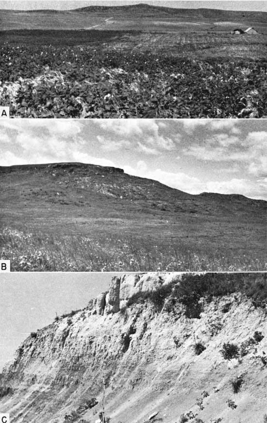
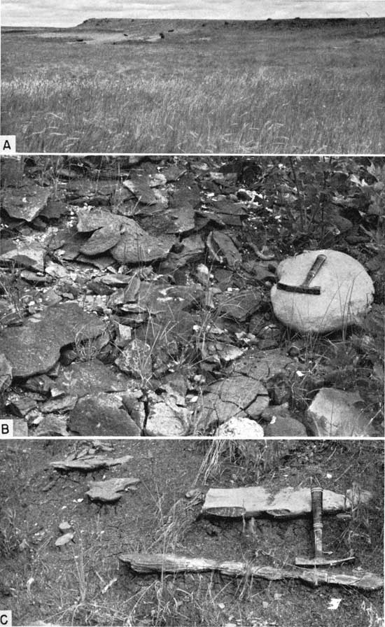
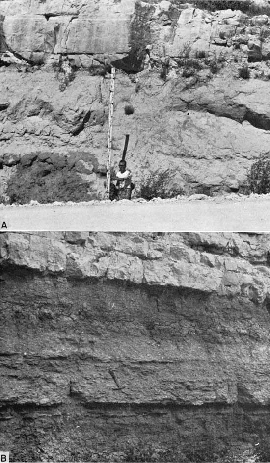
Plate 16--Topography and exposures in Blue Hill outcrop belt. A, Niobrara-capped butte in southwestern Blue Hills, sec. 21, T. 9 S., R. 10 W., Mitchell County. Measured section 31 is located on north (left) side of butte. B, Reference section of Blue Hill Member exposed on Fort Hays escarpment, sec. 29, T. 11 S., R. 16 W., Ellis County (Loc. 25). C, Blue Hill-Codell contact (top of rod) at type locality of Codell Member, sec. 3, T. 11 S., R. 17 W.. Ellis County (Loc. 28). Note sandy beds in uppermost Blue Hill and very thick ledge of Codell near top of photograph.
When the sandstone division, later named Codell, was elevated to member status, the term Blue Hill was thus restricted to the lower shale and concretion division. This change was adopted temporarily by the Kansas Geological Survey (Moore and others, 1944, p. 152); however, Moore and others (1951, p. 24) reverted to the original definition of the Blue Hill Member and included the Codell as a zone within the Blue Hill. Still more recently, Merriam (1957a, p. 8) and Jewett (1959) ranked the Codell as a member and used the term Blue Hill in the restricted sense, and that usage is followed in this report.
As reference section of the member I herewith designate the beds exposed at locality 25 (inset, Pl. 1; Pl. 16B), where the full thickness of the Blue Hill Shale Member is exposed in a linear distance of about 0.5 mile.
Contacts--The contact of the Blue Hill Shale Member with the underlying Fairport Member is easy to determine in the field, and criteria for recognizing it have been outlined above. The boundary between the Blue Hill and Codell, on the other hand, offers some problems in recognition because of the commonly transitional junction of these units. In many exposures, including the reference section of the Blue Hill Shale Member (Loc. 25) and the type section of the Codell Sandstone Member (Loc. 28), a sharp change in slope or road-cut color, from gray to grayish yellow or dusky yellow, is observed where the section changes upward from chiefly silty shale to chiefly sandstone or siltstone. Where marked in this way, the contact between the members can be recognized with little difficulty (Pl. 16C). At many places, however, as at localities 15, 17, 22, and others, the proportion of sand and silt below the Codell is great enough to impart a grayish-yellow color to the slope, even though the rock is predominantly argillaceous shale and is clearly assignable to the Blue Hill Shale Member. Naturally, in some sections the boundary must be placed somewhat arbitrarily because transitional strata are thick. As much as 17 feet of such rock is exposed at locality 47 in Trego County. Before one can attempt to determine the contact, the section must be ditched so as to expose fresh strata. In such a ditch, the transitional strata show a color that is generally either predominantly medium to medium dark gray or predominantly light olive gray (5Y6/1). The former colors indicate a chiefly argillaceous rock, the latter, chiefly siltstone or sandstone. I have followed the practice of placing the contact where the fresh-rock color changes upward from mostly gray to predominantly light olive gray.
Lithology--Most of the Blue Hill Shale Member is blocky to fissile, slightly silty, clayey shale that weathers into small brittle flakes (Pl. 17A). Bedding planes are poorly defined in most fresh exposures. Very fine carbonaceous matter is scattered throughout the shale. The predominant color of the shale is dark gray, but locally the rock is light to dark olive gray. In most exposures, deeply weathered rock is uncommon, but many flakes of partly weathered shale are medium gray. In the lowermost 20 to 25 feet of the member, the shale weathers to light olive gray (5Y6/1) at some places. Concretionary nodules of finely to very coarsely crystalline pyrite are common in some exposures, notably at localities 18 and 32. The nodules are generally an inch or two in greatest dimension. At locality 18, many fossils, particularly Scaphites, are filled with finely crystalline pyrite and even partly or wholly surrounded by this mineral. Very small grains of crystalline pyrite are disseminated in the shale locally. At nearly all exposures the shale is stained along joints and bedding planes by pale-yellow, powdery iron sulfate. Limonitic staining along joints and bedding planes is common also, and is generally concomitant with the iron sulfate stains; indeed, the limonite undoubtedly originated by oxidation of the iron sulfate. At a few places, especially at locality 32, a strong melanterite taste can be detected locally in the gray shale. Calcium sulfate in the form of selenite is especially abundant at many exposures, occurring as minute aggregates along planes of fissility, as coarsely crystalline platy masses in partly weathered shells of Inoceramus, and as large individual or fishtail-twinned crystals several inches in length. At a few places, slopes of the shale glitter by reflection of sunlight from thousands of large selenite crystals. Gypsum and barite occur locally as fossil-replacement minerals.
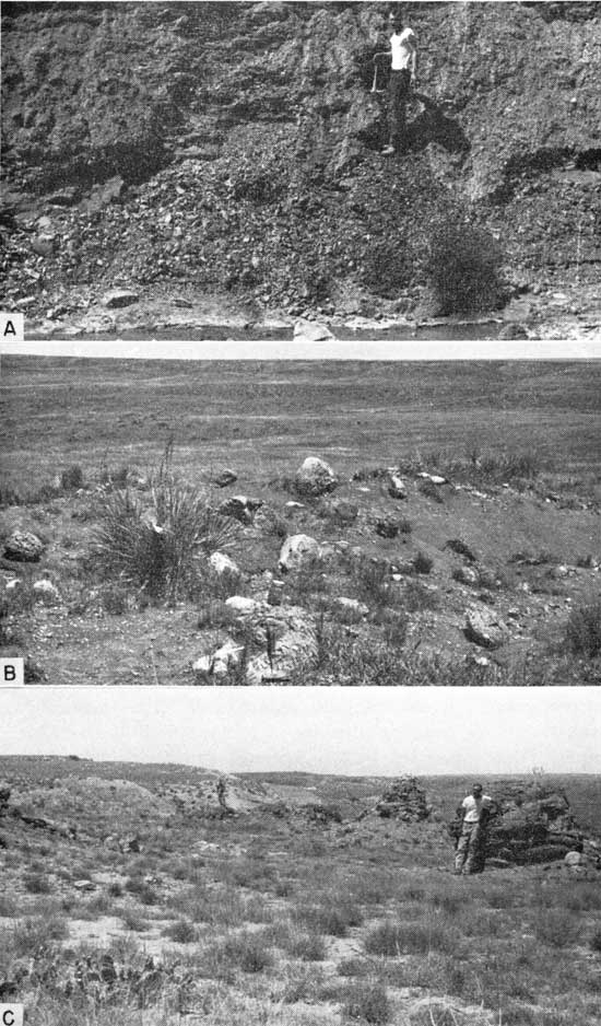
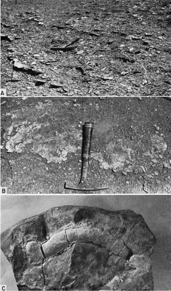
Plate 17--Exposures of Blue Hill Member. A, Typical exposure of unweathered Blue Hill beds, sec. 4, T. 11 S., R. 18 W., Ellis County (Loc. 18). B, Septarian-concretion-studded exposure of Blue Hill Member, sec. 22, T. 15 S., R. 20 W., Ellis County (Loc. 17). C, Gigantic concretions in upper part of Blue Hill Member, sec. 25, T. 22 S., R. 42 W., Hamilton County (Loc. 22).
X-ray study was made of five representative samples of the Blue Hill Shale Member from selected exposures along the Saline River valley. Two additional samples from Jewell County were studied because the field appearance of the rock is not "typical" for the member. Despite the different appearance of the last two samples, the mineral content is harmonious with other analyzed samples. In all samples, quartz is the dominant mineral, and in all but two samples nonclay constituents exceed the total clay-mineral content. In the field, all of the samples were described as being very slightly to slightly silty clayey shale, except sample 28-L, which is very sandy. Thus, most of the quartz is seemingly of very fine silt size or smaller. Kaolinite is the dominant clay mineral in five of the samples and is present in the other two. Montmorillonite, or illite and montmorillonite are dominant in the two samples where kaolinite is not, and occur in nearly equal quantities in all samples. Results of x-ray study of the Blue Hill samples are summarized below. According to Swineford and others (1954, p. 163), minerals in the upper part of the Blue Hill of Ness County are, "in rough order of abundance, montmorillonite, quartz, kaolinite, illite, feldspar, muscovite, and traces of chlorite and gypsum." Except for dominance of montmorillonite, rather than quartz, the Ness County analysis is in accord with those of the present report. The upper part of the Blue Hill is seemingly more bentonitic in Ness County than where the tabulated samples were collected.
| Clay mineral analyses of clayey shale | |||||||
|---|---|---|---|---|---|---|---|
| Sample | Clay minerals | Nonclay | Dominant mineral assemblage |
Dominant mineral |
|||
| Dominant | Moderate | Minor | Dominant | Minor | |||
| 18-B | Kaolinite | Montmorillonite Illite |
Chlorite | Quartz | Dolomite | Nonclay | Quartz |
| 19-Y | Kaolinite | Illite Montmorillonite |
Chlorite | Quartz | Feldspar Gypsum |
Nonclay | Quartz |
| 25-0 | Montmorillonite | Illite Chlorite |
Kaolinite | Quartz | Mica | Clay | Quartz |
| 28-F | Illite Montmorillonite |
Kaolinite | Chlorite | Quartz | Mica | Nonclay | Quartz |
| 28-L | Kaolinite | Illite Montmorillonite |
Quartz | Feldspar | Nonclay | Quartz | |
| 40-P | Kaolinite | Illite Montmorillonite |
Quartz | Clay | Quartz | ||
| 43-A | Kaolinite | Illite Montmorillonite |
Quartz | Calcite | Nonclay | Quartz | |
Beginning as much as 75 feet or as little as 15 feet below the Niobrara, the Blue Hill Member becomes, progressively upward, more silty and finally very sandy at the top. In the lower part of this transition to the overlying Codell Sandstone Member, the quantity of silt grains disseminated in the shale gradually increases. Upward, the shale is interbedded with thin to thick laminae and lenses of light-olive-gray (5Y6/1), very fine grained quartz sand and silt. The small lenses of sand commonly impart a mottled appearance to this part of the shale. Still higher, thin to very thin beds of very fine grained quartz sand or silt alternate with thicker layers of silty or very fine sandy shale. As the quantity of sand increases, the blocky structure of the shale is less prominent, and the weathered rock is only partly flaky. The predominant color of this part of the section is medium dark gray on fresh surfaces, medium gray where weathered. The thickness range of the sandy upper part of the Blue Hill Member in part reflects intergrading facies at the Codell-Blue Hill boundary. Rocks in stratal continuity are assigned to one member or the other, depending on the percentage of coarse silt and sand content. Where the Codell is thickest, the part of the Blue Hill Member that is sandy is generally much thinner than at places where the Codell is poorly developed. X-ray analysis of a sandy shale sample (28-L) is given above.
At several localities in Finney, Ness, Ellis, Hamilton, Osborne, and Mitchell counties one or two thin beds of hard, resistant sandstone or sandy siltstone lie just above or just below the base of the sandy upper portion of the Blue Hill Member. The beds are generally no more than 0.3 foot thick, are gently cross laminated locally, and commonly contain worm? trails or worm castings. Calcareous sandstone or sandy siltstone is exposed in the upper part of the Blue Hill at localities 1, 6, 15, 17, 31, 32, and 39; the calcite may maintain optical continuity through several cubic centimeters of the rock. Most of the sandstone is light gray to medium light gray or light olive gray and weathers to grayish orange, dark yellowish orange, or moderate yellowish brown. Large concretionary masses of gently cross laminated sandstone lie about 35 feet below the top of the Carlile Shale in the sandy part of the Blue Hill Member at locality 39. A layer of sandy calcareous concretions lies in calcareous sandy siltstone about 24 feet below the top of the Carlile at locality 32. Similar concretions, some as much as 8 feet in diameter and mostly of irregular shape, are exposed at several localities in southern Osborne County and lie about 25 feet below the top of the Carlile. At the same horizon in the SW sec. 3, T. 10 S., R. 13 W., Osborne County, a 1.2-foot bed of calcareous siltstone is gently cross laminated and oscillation ripple marked. The ripples have a spacing of approximately 0.2 foot and amplitude of 0.02 foot.
Thin sections were prepared of a calcareous, very fine sandy siltstone (Loc. 17), a noncalcareous siltstone (Loc. 17), and a sandy calcareous concretion (Loc. 32). The first of these contains the following minerals, listed in approximate order of abundance: quartz, feldspar, chert, limonite, and biotite. The cement consists of a small quantity of calcite. The second thin section contains quartz, feldspar, chert, biotite, glauconite. and tourmaline. The rock is cemented by a very fine grained silt and clay matrix, which is dark under crossed nicols. The sandy concretion consists of finely crystalline calcite through which are scattered abundant fine grains of subangular quartz.
Even the most casual observer cannot fail to be impressed by the number and size of the concretions that stud the slopes of every large exposure of Blue Hill Shale (Pl. 17B). Three kinds occur: calcareous septarian concretions (most abundant), noncalcareous clay-ironstone concretions, and sandstone concretions (least common). The concretions are arranged mostly in zones, some of which are useful as marker beds because they can be traced for many miles.
Calcareous septarian concretions are found through a greater stratigraphic range than the other kinds. The position of the lowest septarian-concretion zone of the member ranges from 30 feet above the base, in Osborne County, to about 70 feet above the base, in Finney County. In sections located geographically between, the distance of the lowest concretion zone above the base increases from north to south. Generally, the highest septarian concretions are in the lowest few feet of the fine sandy shale that makes up the upper part of the Blue Hill Shale Member and are correspondingly sandier than other septaria; but concretions lie high in the sandy zone in Osborne, Mitchell, and Hamilton Counties. The vertical interval between the base of the Fort Hays Limestone Member and the highest concretion zone ranges from 22 feet at locality 31, in Mitchell County, to 40 feet at several other localities. Despite the fact that many of the concretions lie in widespread zones, a great number are distributed randomly throughout the shale, and some are arranged in local zones that cannot be traced even to nearby exposures. North of Mitchell and Osborne counties, the number and size of calcareous septarian concretions decreases considerably.
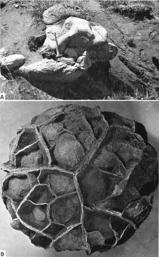
The largest septarian concretions are in Hamilton County, where unbroken specimens as large as 12 feet in diameter and 6 feet in thickness are exposed at locality 20 and at locality 22 (Pl. 17C); some may have been even larger, although most are now partly broken by weathering. In west-central Kansas, the largest concretions seen are at locality 2 in Ness County, where one specimen is 8 feet in diameter and 5 feet in thickness. Complete gradation in size between such gigantic concretions and those only an inch or two in diameter is observed. Many septarian concretions less than 0.5 foot in diameter are nearly spherical, but most larger ones are more or less oblate spheroidal. Many have a smooth, unbroken exterior and some are oddly shaped because of wartlike or ridgelike tuberosities (Pl. 18A). In other specimens, calcite septa project conspicuously from the weathered surface, thus imparting a coarse honeycomb appearance to the concretion, but these are sparse (Pl. 18B). At many places, notably locality 28, adjacent septarian concretions coalesce into irregular rock masses. In southern Osborne County and southwestern Mitchell County, sandy septarian concretions that lie in a zone approximately 40 feet below the top of the Carlile are smooth, nearly spherical, as much as 3.5 feet in diameter, and, because septa are not so extensively developed as in typical septaria, weather concentrically in the outer part.
Plate 18--Blue Hill concretions. A, Warty concretion, marker bed 6, middle part of Blue Hill, sec. 29, T. 11 S., R. 16 W., Ellis County (Loc. 25). B, Weathered septarian concretion, approximately x1, from middle part of Blue Hill, sec. 29, T. 11 S., R. 16 W., Ellis County (Loc. 25).
The unweathered matrix of the concretions is olive gray, dark gray, or medium dark gray or less commonly olive black or medium gray. The weathered surface is yellowish gray (5Y8/1), dark yellowish orange, or grayish orange and less commonly grayish yellow, light gray, or shades of brown. At many exposures one or two zones of vivid dark-yellowish-orange-weathering concretions stand out conspicuously on the slopes. Some of these concretions are stained grayish red, moderate reddish brown, or light brown (5YR5/6). The matrix is very hard, brittle, and calcareous, and ranges in texture from very fine grained to micrograined. Many concretions have an outer "crust" with cone-in-cone structure. Where weathered, such a crust breaks into large numbers of tapered, pencil-like fragments. In other concretions, the outer surface becomes coarsely granular upon weathering.
The septa are mostly grayish brown or moderate brown, less commonly dusky brown, dark yellowish brown, or various shades of yellow and orange. They may be as much as an inch thick and consist of slender fibers of calcite oriented perpendicular to the enclosing walls of concretionary matrix. From the centers of the concretions outward, the septa taper gradually to a wedge edge. Most concretions contain interior-shrinkage cavities lined with the same prismatic calcite that forms septa. Second-generation calcite of white, grayish yellow, or pale yellow generally encrusts the walls of the cavities. This calcite has assumed various crystal habits. Under the effects of long mechanical weathering, the concretions break along septal planes and form heaps of angular fragments.
Pyrite has been described in septarian concretions from northeastern Ness County by Swineford and others (1954, p. 161) but I did not find this to be a usual constituent of septaria.
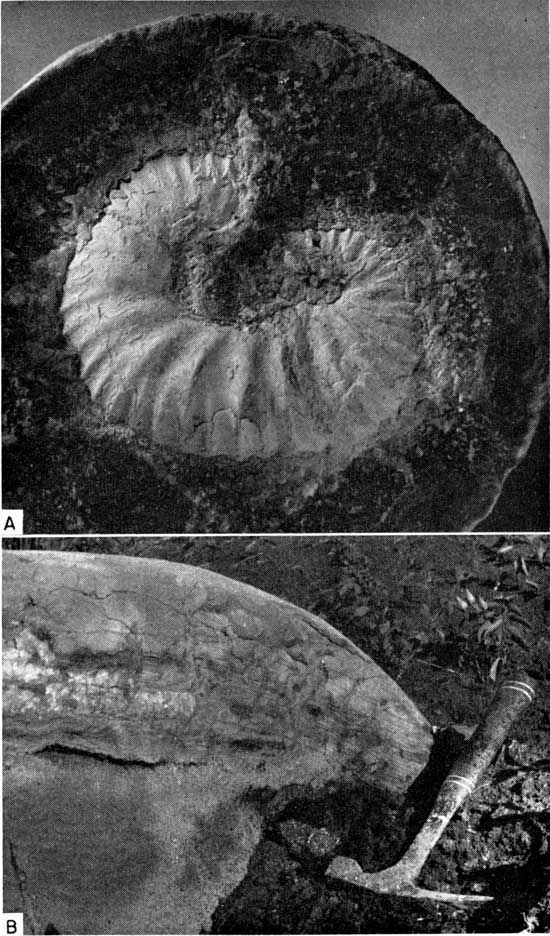
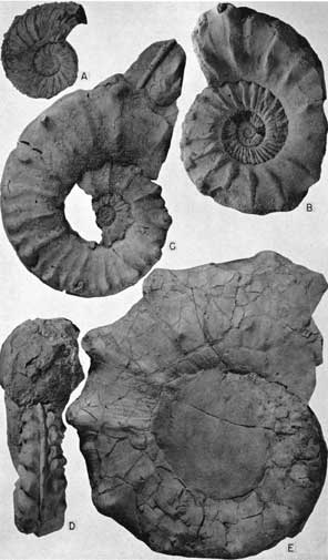
Fossils are common in septarian concretions at some localities and are preserved little damaged in the smaller concretions (Pl. 19A), which break along laminae of the nacreous layers so that the fossils show an iridescence where freshly exposed. Internal shrinkage of larger concretions has shattered most of the contained fossils, but at locality 25 I broke open a large concretion that contained a fairly complete specimen of Collignoniceras hyatti about 1.5 feet in diameter. The most common species preserved in the concretions are C. hyatti, Inoceramus flaccidus, and Scaphites carlilensis.
Plate 19--Blue Hill concretions. A, Small septarian concretion that contains well-preserved Scaphites, x2.7, from middle part of Blue Hill, sec. 24, T. 7 S., R. 14 W., Osborne County (Loc. 49). B, Laminated sandstone layer in septarian concretion in middle part of Blue Hill, sec. 20, T. 9 S., R. 10 W., Mitchell County (Loc. 31). Note uparched condition of sand in center of photograph.
Shale bordering the concretions laterally is commonly sandy or silty. A thin layer of very fine grained sandstone passes through concretions in the sandy upper part of the Blue Hill Shale Member at localities 15, 25, and 31. The sand layer bends downward in the concretion margins at the last two localities, probably as a result of upward expansion of the concretions during growth (Pl. 19B). At several places, including localities 13, 18, 25, and 31, the surrounding shale arches over and is depressed beneath some of the concretions.
Swineford and others (1954) described nodules of hydrated halloysite and alunite from three localities in Ness and Trego counties, Kansas. The nodules are peripheral to the septarian concretions at the concretion-shale contact, and are associated with gypsum.
The second major group of concretions is the noncalcareous clay-ironstone type. These are known from Osborne County, northern Ellis County, and southeastern Smith County. Along the south side of the Saline River valley a zone of such concretions, 1.4 to 1.9 feet thick, caps a low but prominent bench (Pl. 20A). The zone lies 27 to 33 feet above the base of the member. At localities 32 and 45 in Osborne and Smith counties, respectively, clay-ironstone concretions lie in a discontinuous zone of nonuniform thickness approximately 45 to 55 feet above the base of the member. The concretions occupy part of a 10-foot section of shale beneath a marker zone of conspicuous, warty, dark-yellowish-orange-weathering septarian concretions. Presumably the same clay-ironstone zone is exposed at locality 18, in northern Ellis County, where it lies approximately 85 feet above the base. At locality 45, the clay-ironstone concretions are abundant (Pl. 20B) and contain numerous well-preserved fossils.
Plate 20--Blue Hill concretion zones. A, Bench capped by clay-ironstone marker bed 1, lower part of Blue Hill Member, sec. 29, T. 11 S., R. 16 W., Ellis County (Loc. 25). Black spots are cattle. B, Clay-ironstone concretions from marker zone 4, middle part of Blue Hill, sec. 27, T. 5 S., R. 13 W., Smith County (Loc. 45). Hammer lies on septarian concretion from top of zone. C, Calcareous concretion (hammer handle) and clay-ironstone concretion (hammer head) in marker zone 4, middle part of Blue Hill, sec. 27, T. 5 S., R. 13 W., Smith County (Loc. 45).
The clay-ironstone concretions are very flat oblate spheroids and have a narrowly elliptical vertical cross section. Most of the concretions are less than 1.5 feet in diameter and less than 0.25 foot thick, but at locality 18, in northern Ellis County, there is a continuous bed of such concretionary rock. The prevailing color is olive gray; the prevalent weathered colors are grayish red (10R4/2), moderate reddish brown, light brown (5YR5/6), and dark yellowish orange. Most of the concretions are very hard, brittle, resistant to weathering, and fossiliferous. Most common of the fossils are Inoceramus flaccidus, Collignoniceras hyatti, and small gastropods. A few concretions contain thin calcite-filled fractures quite unlike those of the septarian concretions.
In thin section, a typical clay-ironstone concretion consists of uniformly microgranular matrix containing abundant disseminated pyrite, some crystalline aggregates of pyrite, a few very small grains of angular quartz, and limonite. X-ray analysis of a concretion from locality 45 shows a dominance of nonclay minerals, chiefly siderite, and a subordinate quantity of quartz. Clay minerals constitute a maximum of 15 percent of the entire sample and include illite, montmorillonite, and chlorite in almost equal amounts. The same specimen was analyzed chemically and the following percentages were determined:
| Chemical analysis of a clay-ironstone concretion | ||||||||||||
|---|---|---|---|---|---|---|---|---|---|---|---|---|
| Locality | Unit | SiO2 | Al2O3 | Fe2O3 | TiO2 | CaO | MgO | P2O5 | S | CO2 | Loss 140°C |
Total loss, as-rec'd basis |
| 45 | D | 11.9 | 5.08 | 37.4 | 0.094 | 5.70 | 7.36 | 0.095 | 0.12 | 31.4 | 1.11 | 31.4 |
Small sandy concretions can be observed at a few localities in Mitchell, Osborne, and Smith counties, where they occur in close association with clay-ironstone concretions. The sandy concretions are mostly olive gray and weather to moderate yellowish brown, pale to dark reddish brown, or, where very limonitic, dark yellowish orange. Most of the specimens are less than 1 foot in diameter and less than 0.3 foot thick. The rock is composed chiefly of fine quartz sand, silt, and clay, is softer than the ironstone concretions, and generally is weakly calcareous. A few fossil fragments are preserved locally. Such concretions are surrounded by soft, very argillaceous, fine-grained quartz sandstone in some sections and by silty argillaceous shale in others. Sandy concretions that lie near the top of the Blue Hill Member in Osborne County have been noted above.
Probably also of concretionary origin are wall-like masses of calcareous siltstone that lie 23 to 35 feet below the top of the Carlile Shale in sec. 3 and 10, T. 10 S., R. 13 W., Osborne County. Individual structures are as much as 12 feet high, 5 to 6 feet wide, and several hundred feet long. Study of these structures has not been completed.
Bentonite is uncommon in the Blue Hill Member and has been observed at only a few localities. Two varieties are evident, biotitic and nonbiotitic. The former is known from a single horizon in Osborne, Mitchell, and Ellis counties and is light olive gray (5Y6/1), medium gray, or medium olive gray; weathers dark yellowish orange; and contains pyrite nodules as much as 0.4 foot in diameter and 0.15 foot thick at locality 38. Very fine flakes of biotite are scattered throughout, and the bentonite at localities 31 and 38 is gritty. The greatest thickness of the biotitic bentonite seam is 0.15 foot. The nonbiotitic bentonite is like that in the Fairport Member and has been observed at two horizons, the lower of which seems to be widespread in north-central Kansas (Pl. 1). The color ranges from light olive gray (5Y6/1) to yellowish gray (5Y8/1) or very pale orange, and the weathered bentonite is dark yellowish orange. The higher of the two seams of this kind of bentonite is known only at locality 32, where it contains small nodules of pyrite. Seemingly, neither seam of nonbiotitic bentonite reaches a greater thickness than 0.04 foot. At most localities, the bentonite seams are not exposed on weathered slopes but must be located by trenching the section.
Chemical analysis of a bentonite sample from the lower part of the Blue Hill Member is shown below. The large weight loss is due to the expulsion of water from clay minerals that dominate the sample.
| Chemical analysis of a Blue Hill bentonite | ||||||||||||
|---|---|---|---|---|---|---|---|---|---|---|---|---|
| Locality | Unit | SiO2 | Al2O3 | Fe2O3 | TiO2 | CaO | MgO | P2O5 | S | CO2 | Loss 140°C |
Total loss, as-rec'd basis |
| 31 | B | 46.9 | 21.8 | 5.20 | 0.56 | 2.66 | 3.92 | 0.29 | 0.68 | 0.10 | 0.28 | 18.5 |
X-ray analysis was made on samples of biotitic bentonite from localities 25 and 31. In both samples the dominant mineral is montmorillonite; very small quantities of illite and kaolinite are present. Among the nonclay minerals biotite is dominant; small quantities of quartz and possibly feldspar were recorded. The sample from locality 31 also contains some gypsum. Both samples are bentonite in the strict sense of the word.
Marker beds--The large number of septarian-concretion zones and monotonous aspect of most Blue Hill strata make especially desirable the description of key beds that can be used as stratigraphic markers. Fortunately, concretions in all zones are not alike, and two bentonite seams can be traced for a considerable distance. Beds that serve as markers are described below in numbered order, upward from the base of the section (Pl. 1).
1. Clay-ironstone concretions. Lowest of usable marker beds in the Blue Hill Shale Member is a 1.4- to 1.9-foot zone of clay-ironstone concretions that lies 27 to 33 feet above the base of the member along the Saline River valley in northern Ellis County (Loc. 19, 23, and 25). The zone can be recognized by the conspicuous topographic bench that it upholds (Pl. 20A). Inoceramus flaccidus, a finely ribbed Collignoniceras, and a small gastropod are common fossils in the zone.
2. Septarian concretions. A few feet above the clay-ironstone concretions lies a 4.0- to 8.6-foot zone of small, oblate-spheroidal septarian concretions that weather dark yellowish orange to yellowish gray (5Y8/1). The zone lies about 38 feet above the base in sections along the Saline River valley in northern Ellis County (Loc. 19, 23, and 25). A large Inoceramus and a small finely ribbed ammonite, like those in the clay-ironstone-concretion zone, are characteristic fossils, together with minute gastropods and the small thick-shelled clam Lucina. Most of the concretions are less than 0.5 foot thick by 1.5 feet in diameter, but a few reach 3.5 feet in diameter. At locality 38, in eastern Osborne County, a single 0.15-foot layer of similar concretions lies 18.4 feet above the base of the Blue Hill Member. Proximity of both this layer and the calcareous concretion zone of Ellis County to the next higher marker bed, a biotitic bentonite layer, suggests that the Osborne County concretions represent marker bed 2 of Ellis County.
3. Bentonite. The third major marker bed in the Blue Hill Member lies 4.0 feet to 10.8 feet above the calcareous concretion zone and is a 0.1- to 0.15-foot medium-gray to light-olive-gray biotitic bentonite. This layer has been observed in Mitchell and Osborne counties and northern Ellis County at localities 23, 25, 31, and 38. At locality 38 it rests 22.4 feet above the base of the Blue Hill and at locality 25 is 54.0 feet above the base. A conspicuous layer of nearly spherical, dark-yellowish-orange-weathering calcareous septarian concretions lies at or near the bentonite level along the Saline River valley in northern Ellis County. The concretion zone is the 47- to 50-foot zone reported by Rubey and Bass (1925, p. 35).
4. Concretions. The fourth useful marker zone has been identified in Osborne and Mitchell counties (Loc. 31, 32, 38, and 45) and possibly in northern Ellis County (Loc. 18). Small oblate-spheroidal concretions of varied composition form a zone that ranges from 2.3 (Loc. 31) to 10.4 feet thick (Loc. 45, Pl. 20C) and lies 29.5 (Loc. 38) to 43.6 feet (Loc. 31) above the biotite-bearing bentonite seam. At locality 38, the zone lies 52 feet above the base of the member. Three kinds of concretions are included: (1) clay ironstone (Loc. 18 and 45), (2) calcareous septarian concretions (Loc. 45 and 38), and (3) moderately calcareous, ferruginous, sandy concretions (Loc. 31, 32, 38, and 45). Most of the concretions are not more than 0.3 foot thick and 2 feet in diameter. One layer at locality 18 is continuous throughout its exposure.
5. Septarian concretions. The fifth useful marker bed above the base of the Blue Hill Shale Member is a zone of calcareous septarian concretions that can be traced from locality 17 in southwestern Ellis County to locality 44 in northeastern Jewell County, a distance of approximately 110 miles along the trend of outcrop. Chief characteristic of the unit is the extremely irregular shape of most of the concretions. Except at locality 17, the concretions have large wartlike or rounded ridgelike tuberosities that are especially prominent and serve to set this zone apart from others stratigraphically near it (Pl. 18A). The concretions are predominantly olive gray and weather yellowish gray or a very conspicuous dark yellowish orange. The zone ranges from 1.0 foot thick at locality 44 to 4.8 feet thick at localities 23 and 25 in northeastern Ellis County. The zone lies 55 feet above the base of the member, at locality 38 in eastern Osborne County, to 101.6 feet above the base, at locality 23 in northeastern Ellis County.
6. Bentonite. A very thin bentonite seam that can be traced from locality 44 in northeastern Jewell County to locality 38 in southeastern Osborne County lies 4.1 to 7.2 feet above the zone of warty concretions. The seam ranges in thickness from 0.02 to 0.04 foot, is light olive gray to yellowish gray, and weathers dark yellowish orange. A bentonite that is 0.01 foot thick and that lies at or near the base of the warty concretion zone (marker bed 5) at localities 23 and 28 in northeastern Ellis County may be equivalent. If so, the warty concretions in Jewell, Mitchell, and Osborne counties are somewhat older than those in Ellis County (see Pl. 1).
7. Septarian concretions. In the upper 50 feet of the Blue Hill, seemingly only one lithologic zone can be recognized with ease over a broad area. A zone of very large oblate-spheroidal calcareous septarian concretions lies at or near the base of the silty and fine sandy upper part of the member in Finney, Ness, and Trego counties, and southwestern Ellis County. The zone can be recognized by its proximity to the transitional beds, and by the large size and vivid dark-yellowish-orange weathering of the concretions that permits field recognition of the zone even from long distances. The largest concretions are at locality 2, Ness County, and are as much as 8 feet in diameter and 5 feet high. Thickness of the zone ranges from 3.5 feet at locality 6 in Finney County to 10.5 feet at locality 1 in northeastern Ness County. The vertical distance below the Fort Hays Limestone Member of the Niobrara Chalk ranges from 33.1 feet at locality 48 to 46.1 feet at locality 15. Near the base of the transition between the lower clayey shales and upper sandy beds of the Blue Hill Member in Hamilton County a zone of gigantic calcareous septarian concretions lies about 25 feet below base of the Niobrara (Pl. 17C). These concretions are oblate spheroids, weather grayish orange to dark yellowish orange, and are as much as 12 feet in diameter by 6 feet in thickness. Stratal continuity of this zone with that just described from Finney, Ness, Trego, and Ellis counties seems probable. A similar zone of giant concretions, lying in nearly the same stratigraphic position in Baca County, Colorado (McLaughlin, 1954, p. 121), is probably the same as that in Hamilton County. Dane and others (1937, p. 216) reported a zone of septarian concretions, individually as much as 10 feet in diameter, from near the top of the Blue Hill equivalent in Prowers and Bent Counties in easternmost Colorado. This zone averages 10 feet in thickness and terminates vertically at the transition between dark-gray clayey shale and gray sandy shale. At least a part of the zone is equivalent to that in Hamilton County.
From locality 13 in west-central Ellis County to locality 39 in north-central Osborne County a layer of septarian concretions lying approximately 40 feet below the Fort Hays Limestone is probably the northern equivalent of the widespread zone described above, but the conspicuous coloration is lacking. At most localities the layer is only one concretion in thickness, and the concretions are not so numerous as southwestward. The layer may be recognized by the larger average size of the concretions than those in adjacent zones, position with respect to the Fort Hays Limestone and base of the sandy upper part of the Blue Hill Shale Member, and the smoothly ellipsoidal or even cannonball-like appearance of the unbroken concretions.
Thickness and distribution--There are few places in Kansas where the entire thickness of the Blue Hill Member is exposed and can be measured accurately. The minimum thickness is 72 feet at localities 20 and 22 in Hamilton County, and at locality 44 in Jewell County the thickness of the member is estimated to be 215 feet, of which 192 feet is exposed. Generally, the member thins gradually southwestward across Kansas.
According to Condra and Reed (1959, p. 17), the Blue Hill Shale Member in Nebraska is about 80 feet thick in the east, 100 feet in the southwest, and 400 to 500 feet thick in the northwest. Well records published as Reports of Investigations of the South Dakota Geological Survey are, for the most part, insufficiently detailed to permit widespread recognition of the Blue Hill in that state. In a few South Dakota sections the Carlile sequence includes, in upward order, chalky or calcareous shale, gray shale, and sandstone, which probably can be classed as Fairport, Blue Hill, and Codell equivalents, respectively. In these few sections the calcareous strata are only 10 to 20 feet thick. In other sections, however, calcareous strata lie between sandstone of the Codell above and noncalcareous shale below. Furthermore, the sub-Codell section contains prominent sandstone locally. In general, dark-gray clay and silty shale make up part of the section below the Codell in every South Dakota subsurface section, but relation of these shales to the Blue Hill is obscure. Despite the difficulties attending recognition of a Blue Hill equivalent in the South Dakota subsurface, gray noncalcareous concretionary shale lies between fine-grained sandstone above and calcareous strata below, as far north as southwestern Manitoba. Here the shale is the lower part of the Vermilion River Formation. This shale is homotaxial with the Blue Hill Member and is undoubtedly its lithogenetic equivalent.
On the north flank of the Black Hills (Cobban, 1951, p. 2187) the Blue Hill equivalent consists of as much as 140 feet of dark-gray shale, including two bentonite layers near the base of the shale, and clay-ironstone and calcareous septarian concretions in the upper part. The shale is bounded below by 13 feet of gray shale with calcareous partings and above by sandstone of the Turner Sandy Member of the Carlile. Southwestward, these lithologic units pass laterally into the Colorado Shale of the Powder River Basin (Haun, 1958). Farther northwest, in central Montana, the Blue Hill Member is probably represented by two lithologic units within the Colorado Shale, (1) a lower dark-bluish-gray fissile shale, and (2) an upper dark-gray shale containing clay-ironstone and some calcareous concretions (Cobban, 1951, p. 2190). Concretion-bearing shale lies in a similar stratigraphic position in the Sweetgrass Arch of north-central Montana, but the shale can be compared with the Blue Hill Member better by its fossils than by specific lithologic characters.
In southeastern Wyoming, divisions of the Carlile are not generally recognized, but septarian-concretion-bearing gray shale continuous with the Blue Hill is known as far west as Carbon County (Cobban and Reeside, 1952a, p. 1942), where it intertongues with sandstone of the Frontier Formation. Essentially the same relations at the south end of the Powder River Basin of Wyoming are shown graphically by Haun (1958).
According to Merriam (1957a), the Blue Hill Shale Member can be traced throughout the western Kansas subsurface, but the concretion zones are not recognizable. Westward through northeastern Colorado, the divisions of the Carlile are lost, and in the Golden Quadrangle, Colorado (Van Horn, 1957), the Carlile equivalent consists wholly of siltstone and sandstone. Farther south, however, along the north side of Arkansas River in southeastern Colorado, the Blue Hill equivalent has been described by Dane and others (1937, p. 215). No complete section was measured by them, but at one locality, 56 feet of the member was exposed. South of Arkansas River, more than half of the 85 feet of Carlile in Baca County (McLaughlin, 1954, p. 121) is lithologically and stratigraphically equivalent to the Blue Hill Shale Member. Mann (1958, p. 158) reported 93 feet of dark to black, platy, clayey shale between the Fairport and Codell Members in Fremont County, Colorado, but he made no mention of concretions or lack of them. In the Model Anticline of Las Amimas County, Colorado, Bass and others (1947) reported 70 to 100 feet of dark-gray fissile shale, the tipper half of which contains septarian concretions, between limy and chalky shale below (Fairport) and sandstone (Codell) above.
In northeastern New Mexico, dark-gray concretionary shale forms the middle part of the Carlile in Colfax County (Griggs, 1948, p. 29) and makes up most of the Carlile in San Miguel County (Griggs and .Hendrickson, 1951, p. 31). Westward from the longitude of Las Vegas, New Mexico, the Carlile contains the Juana Lopez Sandstone, which Cobban and Reeside (1952) correlated with the Codell. The section beneath the Juana Lopez and above the Greenhorn is nearly all black, fissile, sandy shale that generally contains calcareous concretions in the upper half (Rankin, 1944). At least the upper half of this shale is laterally continuous with the Blue Hill Member, but the lower part probably grades eastward into the Fairport. In the San Juan Basin of northwestern New Mexico, the Blue Hill Member is represented by dark-gray, fissile, sandy and concretionary shale within the Mancos Shale.
Fossils and correlation--At most exposures, the Blue Hill Member is poorly fossiliferous, but at a few places in Ellis, Osborne, Mitchell, and Smith counties, fossils are not only abundant but also exceptionally well preserved. The best fossils come from part of the section adjacent to the marker zone of warty concretions, described above. Well-known localities are those here numbered 18, 31, 45, 49, and 50. Other good fossil-collecting areas include localities 9, 19, 23, 25 (Pl. 21A, B), 32, 38, 40, and 48. At some localities, such as 31, 32, and 38, the best-preserved fossils are in small septarian concretions (Pl. 19A); at locality 45, most of the fossils are in ferruginous claystone concretions (Pl. 21C); at locality 18, some fossils are enclosed in nodules of pyrite; elsewhere most of the fossils are enclosed in the shale. Most are preserved as original material, are nearly white, and have a dull luster, but iridescence of the nacreous layers is common in many ammonites and pelecypods. In such fossils purple, green, red, and gold colors predominate and some specimens are truly objects of great beauty. Locally, as at localities 19 and 23, specimens of Inoceramus flaccidus are replaced by gypsum. At locality 44 and elsewhere in Jewell County, fragments of I. cuvieri have been replaced by barite. Internal molds of I. flaccidus, Scaphites, and Collignoniceras are common where fossils have lain exposed to weathering, because the shell matter is fragile and flakes off readily.
Plate 21--Blue Hill fossils. A, Fragments of Inoceramus cuvieri in lower part of Blue Hill, sec. 29, T. 11 S., R. 16 W., Ellis County (Loc. 25). B, Close view of large I. cuvieri showing typical preservation, same locality. C, Clay-ironstone concretion that contains cylindrical phosphatic structure of probable organic origin, x1.3, middle part of Blue Hill, sec. 27, T. 5 S., R. 13 W., Smith County (Loc. 45).
Chief among the Blue Hill fossils are mollusks, especially pelecypods and ammonites. The following list includes the macrofossils collected during the present investigation. The most abundant and characteristic fossils are preceded by an asterisk. Guide fossils are preceded by a dagger. Rare forms are followed by an asterisk. The ranges are plotted in Table 2 and the more common forms are illustrated in Plates 22 through 25.
| Fossils observed in the Blue Hill Member | ||
|---|---|---|
| Mollusca | ||
| Pelecypoda | ||
| *Inoceramus flaccidus White | ||
| Inoceramus latus Sowerby | ||
| Inoceramus cuvieri Sowerby | ||
| †Lucina juvenis Stanton | ||
| Ostrea congesta Conrad | ||
| Yoldia subelliptica Stanton | ||
| Yoldia n. sp. | ||
| Gastropoda | ||
| †Bellifusus willistoni (Logan) | ||
| Gastropods, gen. et sp. indet. | ||
| Gyrodes sp. | ||
| Oligoptycha n. sp.* | ||
| Tessarolax n. sp. | ||
| Cephalopoda | ||
| †Binneyites aplatus (Morrow)* | ||
| †*Collignoniceras hyatti (Stanton) | ||
| Collignoniceras (Selwynoceras)? sp.* | ||
| Proplacenticeras pseudoplacenta (Hyatt) | ||
| †*Scaphites carlilensis Morrow | ||
| Arthropoda | ||
| Crustacea | ||
| Linuparus canadensis (Whiteeaves)* | ||
| Raninella? sp.* | ||
| Vertebrata | ||
| Chondrichthyes | ||
| Isurus appendiculata (Agassiz) | ||
| Ptychodus whipplei Marcou* | ||
| Scapanorhynchus raphiodon (Agassiz) | ||
| Scapanorhynchus sp. cf. S. raphiodon (Agassiz) | ||
| Squalicorax falcatus (Agassiz) | ||
| Osteichthyes | ||
| Teleost bones, teeth, scales | ||
| Incertae sedis | ||
| Coprolites | ||
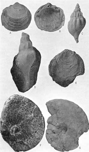
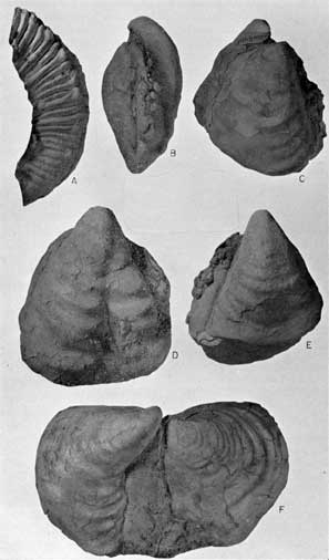
Plate 22--Blue Hill fossils. A, B, Lucina juvenis Stanton, both x2. A, Exterior, left valve; B, Interior, same valve, middle part of Blue Hill (Loc. 45), hypotype, KU10542P1. C, D, Bellifusus willistoni (Logan). C, Well-preserved conch of young individual, middle part of Blue Hill (Loc. 45), x2, hypotype, KU10542G1. D, Somewhat weathered conch of mature individual, partly embedded in concretion, middle part of Blue Hill (Loc. 45), x1, hypotype, KU10542G2. E, Inoceramus latus Sowerby, interior view (Loc. 52), x1, hypotype, KU10544P1. F, G, Proplacenticeras pseudoplacenta (Hyatt). F, Internal mold, middle part of Blue Hill (Loc. 49), x1, hypotype, KU10538A1; G, Exterior view of specimen from middle part of Blue Hill (Loc. 18), x1/2, hypotype, KU10533A1. This plate available in higher quality in an Adobe Acrobat PDF file containing several plates.
The ammonite Collignoniceras hyatti has been suggested by Cobban and Reeside (1952, p. 1018) as a zonal index for strata here referred to the Blue Hill Member. They stated, "This zone is widely distributed in the Great Plains and in eastern Utah." To Western Interior strata containing C. hyatti, Reeside (1957) assigned a late middle Turonian age. The species is known generally throughout the area where the Carlile is recognized as a formal subdivision of the Upper Cretaceous sequence. Westward, the zone can be traced into the Mancos Shale of eastern Utah. In Wyoming and northern Utah, C. hyatti is distributed widely in the Frontier Formation (Cobban and Reeside, 3-952a). Northwest of the Black Hills, C. hyatti has been collected from the Colorado Shale on the Sweetgrass Arch of northwestern Montana (Cobban, 1951, p. 2191). In Canada, C. hyatti is known as far north as northwestern Alberta, where it has been collected from the Kaskapau Formation (MeLearn, 1937, p. 115). Moreman (1942, p. 213) reported this species from the Arcadia Park Formation of the Eagle Ford Group of Texas. Several authors have reported its occurrence in the Mancos Shale of New Mexico. In Kansas, a specimen of C. hyatti was collected from the basal 3.5 feet of the Blue Hill Member at locality 20, and at locality 9 a specimen was found in the basal 10 feet of the member. Juvenile specimens of Collignoniceras, probably C. hyatti, have been observed in the lower 25 to 30 feet of the member at localities 9, 17, 19, 25, and 38. At locality 40, poorly preserved specimens probably referable to this species were collected from shale less than 20 feet below the top of the member. The species ranges seemingly throughout the Blue Hill Member but is most abundant and best preserved in beds adjacent to the warty concretion marker zone at localities in northern Ellis County, southwestern Mitchell County, Osborne County, and southeastern Smith County.
Most abundant of all Blue Hill species in my collections is Scaphites carlilensis, which was thought by Cobban and Reeside (1952) to be restricted to the zone of Collignoniceras hyatti. The type specimen is from the Blue Hill Member in southeastern Mitchell County (Loc. 50). This species has a much smaller reported geographic distribution than C. hyatti, and according to Cobban (1951a, p. 21), is known outside of Kansas only from the north flank of the Black Hills, on the Cat Creek Anticline of central Montana, and on the Sweetgrass Arch of north-central Montana. Scaphites morrowi (=S. pygmaeus), described originally from the same locality as S. carlilensis, differs from the latter mostly in size. I have compared the types of these species and have examined, from the same stratigraphic horizon, specimens ranging in size from less than half the length of S. morrowi to considerably larger than the holotype of S. carlilensis. The two are undoubtedly conspecific. On this basis, recognition of S. pygmaeus in the Arcadia Park Formation of the Texas Eagle Ford Group by Moreman (1942, p. 216) extends the geographic range of S. carlilensis considerably. Kansas specimens are from beds adjacent to the warty concretion zone in northern Ellis County, Osborne County, southwestern Mitchell County, and southeastern Smith County. Poorly preserved scraps of Scaphites from sandstone 10 feet below the top of the member at locality 22 and from the basal 10 feet of the member at locality 9 may belong to this species.
Only one other species, Inoceramus flaccidus, is truly abundant in the Blue Hill Shale Member. The type material is from the Niobrara beds near Pueblo, Colorado (Stanton, 1899, p. 634). This species has received little attention but has been reported from the Niobrara of Kansas by Logan (1898, p. 485) and from the upper part of the Colorado Shale of Wyoming and Montana. Matsumoto has examined many of the Blue Hill specimens and identified several as I. flaccidus and a few as I. sp. cf. I. flaccidus. The Kansas species exhibits a wide range of form, showing gradation from coarsely and irregularly wrinkled specimens with a well-defined posterolaterally directed furrow to others with quite smooth shells in which the furrow is only faintly depressed. The latter form is very similar in appearance to I. howelli. I. flaccidus is abundant adjacent to the warty concretion zone (marker bed 5) at most exposures in northern Ellis County, southwestern Mitchell County, Osborne County, and southeastern Smith County. In addition, it is common in the zone of ferruginous claystone concretions that lies 27 to 33 feet above the base of the member along the Saline River valley in northern Ellis County. A single poorly-preserved internal mold from the lowest 10 feet of the member at locality 9 may belong to this species.
Of the other invertebrate species that range beyond Kansas, only Lucina juvenis is restricted to the Carlile. It was described originally by Stanton (1893, p. 98) from the "Pugnellus sandstone" in the upper part of the Colorado Carlile and seemingly has a narrow geographic distribution.
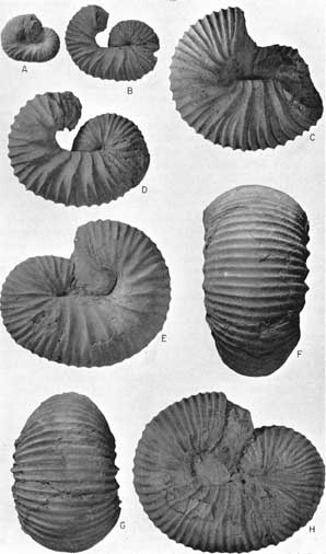
Plate 23--Fossils from middle part of Blue Hill. A-H, Scaphites carlilensis Morrow, all x1. A, Internal mold (Loc. 48), hypotype, KU10537A1. B, Locality 18, hypotype, KU10533A2. C, Locality 18, hypotype, KU10533A3. D, Locality 18, hypotype, KU10533A4. E, Locality 50, holotype, KU7802-3. F-H, Ventral, end, and side views of specimen (Loc. 31), hypotype, KU10540A1. This plate available in higher quality in an Adobe Acrobat PDF file containing several plates.
Widespread, long-ranging invertebrate species in the Blue Hill Shale Member include Ostrea congesta, Inoceramus cuvieri, Proplacenticeras pseudoplacenta, Yoldia subelliptica, and Linuparus canadensis. The first two of these have been discussed with the Fairport fauna. P. pseudoplacenta ranges geographically from Kansas to Utah and from Texas to northwestern Alberta. Moreman (1942, p. 219) described P. pseudoplacenta var. occidentale from the Britton Formation of the Eagle Ford Group of Texas. These beds are of Greenhorn age. The species ranges upward to beds of Niobrara age in the Cody Shale (Reeside, 1927, p. 2). Y. subelliptica ranges geographically from New Mexico to Alberta and has been reported from beds as old as Cenomanian in the latter area by Warren and Stelck (1940, p. 145). L. canadensis is known from Tennessee to British Columbia and has been collected from several horizons, ranging from as low as the Eagle Ford of Louisiana and the Carlile of the Black Hills area to as high as the Ripley Formation of Tennessee (Rathbun, 1935, p. 36).
Species not reported from outside of Kansas include Binneyites aplatus and Bellifusus willistoni. Blue Hill invertebrates that cannot be identified specifically, because of poor or incomplete preservation, include Gyrodes sp., gastropods, gen. et sp. indet., Collignoniceras (Selwynoceras)? sp., and Raninella? sp. Specimens of Selwynoceras have hitherto been reported only from the lower Turonian, and accordingly the discovery of a specimen in the zone of C. hyatti would extend considerably the known geologic range of the subgenus, because the Blue Hill Member has been assigned a late middle Turonian age by Reeside (1957). Previously undescribed species of the Blue Hill fauna assignable to the genera Tessarolax, Oligoptycha, and Yoldia will be treated fully in a separate paper.
Apparently only one Blue Hill invertebrate species is both short ranged and intercontinental in geographic distribution. This form, Inoceramus latus, has been discussed in connection with the Fairport fauna, of which it is more typical. The abundance of I. latus in the lowermost 10 feet of the Blue Hill Member at locality 9 might be interpreted as an indication that the strata there are of Fairport age but of Blue Hill lithology, but presence of imperfect specimens of Collignoniceras hyatti, I. flaccidus, and unidentified gastropods (molds), as well as lack of reaction by the shale to acid, show that the beds are correctly classed as Blue Hill.
To the above list of macrofossils may be added Ostrea lugubris. A single specimen of this species from Mitchell County, Kansas, was collected and identified by J. B. Reeside, Jr.
Plate 24--Fossils from middle part of Blue Hill. A-E, Collignoniceras hyatti (Stanton). A, Internal mold (small amount of shell material adhering) of juvenile specimen (Loc. 31), x1, hypotype, KU10540A2. B, D, Well-preserved immature specimen (Loc. 18), x1, hypotype, KU10533A5. C, Internal mold (some shell material adhering) of nearly mature individual (Loc. 49), x1/2, hypotype, KU10538A2. E, Mature individual (Loc. 45), x3/8, hypotype, KU10542A1. This plate available in higher quality in an Adobe Acrobat PDF file containing several plates.
Among shark teeth found in the Blue Hill Member, all but Ptychodus whipplei have intercontinental geographic distribution and great geologic range. P. whipplei has been reported only from South Dakota, Wyoming, Colorado, Kansas, New Mexico, and Mexico and is seemingly restricted to beds of Carlile and Niobrara age.
Morrow (1934) discovered no Foraminifera in the strata here referred to the Blue Hill Member. Griffith (1947, p. 20), in an unpublished master's thesis, listed 36 species (eight undescribed previously) from the Blue Hill strata of the Republican River valley of Kansas and Nebraska. Five of the species are known also from the Fairport, and four of the five are known in the Niobrara. A total of eight Blue Hill species range into the Niobrara. Griffith (1947) noted that 23 Blue Hill species are known from the Texas Upper Cretaceous, but most of these come from formations younger than Eagle Ford, the upper part of which is correlative with the Blue Hill Member of Kansas. Of stratigraphic and paleoecological significance is the fact that the Blue Hill Member is marked by the presence of arenaceous Foraminifera, whereas the Fairport is known only to contain calcareous species (Griffith, 1947, p. 22). The part of the unnamed member of the Carlile Shale near Belle Fourche, South Dakota, that contains the C. hyatti fauna contains eight species of Foraminifera, according to Fox (1954. p. 101). Although several forms have been reported by Griffith and Fox, none of the published species is restricted to strata equivalent to the Blue Hill. Other papers in which Carlile species are listed are insufficiently detailed stratigraphically to warrant discussion here. Knowledge of Upper Cretaceous Foraminifera from the Western Interior region is not yet extensive enough to permit correlation of the Blue Hill Shale Member by its microfauna.
Plate 25--Blue Hill and Codell fossils. A, Prionocyclus wyomingensis Meek, rubber cast of external mold, topmost Codell (Loc. 22), x1/2, KU12058. B-F, Inoceramus flaccidus White. B, C, E, Views of anterior, right valve, and left valve, respectively, of specimen that has only faint concentric folds, middle part of Blue Hill (Loc. 18), x1/2, hypotype, KU10533P1. D, Left valve of specimen that has pronounced concentric folds, middle part of Blue Hill (Loc. 48), x1/2, hypotype, KU10537P1. F, Paired valves of specimen that has moderately developed concentric folds, middle part of Blue Hill (Loc. 18), x1/2, hypotype, KU10533P2. This plate available in higher quality in an Adobe Acrobat PDF file containing several plates.
Codell Sandstone Member
Name and definition--Bass (1926, p. 28) gave the name "Codell sandstone bed" to sandstone lying at the top of the Blue Hill Shale "in the bluffs along the Saline Valley in Ellis County, 5 miles south and a little west of Codell" (Pl. 16C). The original description characterizes the Codell as consisting of two very thick beds of sandstone separated by a foot of shaly sandstone and including at the top a few inches of clayey rock that weathers to produce a notch below the Fort Hays Member. The lower sandstone bed grades downward into the shale below. A thickness of sandstone that ranges from 3.5 to 22 feet was recorded in Ellis County by Bass (1926, p. 28), and he included in the Codell a few feet of sandy shale that lies below the sandstone at Yocemento (locality 13 of this report) and in southwestern Ellis County (vicinity of locality 17 of this report). In Hamilton County, likewise, about 23 feet of gritty shale beneath 2 feet of sandstone was included in the Codell by Bass (1926, p. 63).
In 1933, Dane and Pierce elevated the Codell to member status, but this change in rank did not appear in publications of the Kansas Geological Survey until 1943 (McLaughlin, 1943, p. 133). This use was continued until 1951 when Moore and others (p. 24) relegated the Codell to the informal rank of zone within the Blue Hill Shale Member of the Carlile. This usage prevailed until recently, when Merriam (1957a, p. 8) and Jewett (1959) re-elevated the Codell to member status. As presently conceived, the Codell consists of sandstone, silty sandstone, or sandy siltstone lying above the Blue Hill Member. A boundary between the Blue Hill and Codell is difficult to select because of the completely gradational nature of the contact at many localities. Criteria for recognition of this contact have been described above under the heading "Blue Hill Shale Member".
Contacts--The contact of the Codell and Blue Hill Members is generally abrupt in Smith and Jewell counties, where the Codell is less than 1 foot thick, and is fairly sharp at localities 25 and 28 (Pl. 16C), where the Codell is well developed. In most other areas, however, the contact is gradational, and the boundary between chiefly shaly strata of the Blue Hill and chiefly sandy strata of the Codell is best marked by a change in slope color, as described above.
The contact between the Codell Member and overlying Fort Hays Member of the Niobrara Chalk is generally very even and knife-edge in sharpness; chalky limestone of the Fort Hays rests on noncalcareous sandstone (Pl. 26A) or argillaceous shaly sandstone of the Codell (Pl. 26B). At locality 25, the contact, though abrupt, is distinctly and irregularly undulatory. Locally, the topmost part of the Codell is calcareous, as at locality 24, probably because of local downward percolation of lime-rich water from the Fort Hays. At some localities, the bottom-most inch or two of the Fort Hays is sandy, undoubtedly consisting in part of reworked Codell, but the sandiness diminishes upward abruptly. At locality 40, the base of the Fort Hays is so sandy that the contact between Carlile and Niobrara seems to be transitional. Locality 22, in Hamilton County, displays the most puzzling conditions. Here, typical sandstone of the Codell is overlain by 0.1 foot of silty and sandy chalk that resembles Fort Hays in lithology. The sandy chalk, in turn, is overlain by a discontinuous bed of hard, Inoceramus-prism-limestone lenses that contain molds of Prionocyclus wyomingensis, a typical Carlile species. Above the hard limestone is sandy and chalky limestone that contains polished, black phosphate pebbles 0.2 foot above the base. The lenses of hard limestone seemingly lie within the Niobrara, but the ammonite P. wyomingensis, which is typical of the Codell in eastern Colorado, bespeaks a Carlile age for them. The sand in the limestone above the lenses is undoubtedly reworked Codell.
Plate 26--Exposures of Codell Member. A, Upper part of Cbdell at type locality, sec. 3, T. 11 S., R. 17 W., Ellis County (Loc. 28). Note sharp contact (top of rod) with Niobrara Chalk. B, Codell Member on W line sec. 21, T. 15 S., R. 20 W., Ellis County. Lower part of Codell (hammer) very sandy; upper part very argillaceous, shaly, and in sharp contact with Niobrara Chalk (top of photo).
If the hard limestone lenses containing Prionocyclus wyomingensis are a part of the Codell Sandstone Member or have been derived from the Codell, then at least the upper part of the Codell Member in Kansas is obviously equivalent to part of the zone of P. wyomingensis, a zone that is widespread in the Great Plains. In the Black Hills, the P. wyomingensis zone is separated from the zone of Collignonicerashyatti by the zone of Scaphites warreni, which occurs in the Codell Member at Colorado City, Colorado, in association with P. wyomingensis (Dane and others, 1937, p. 218); the zone of S. warreni is not altogether lacking in the southern Great Plains region. S. warreni has not been identified in Kansas, perhaps owing to poor preservation; a scrap of Scaphites from the hard brownish-gray limestone at locality 22 is unidentifiable specifically. Despite the lack of evidence of the S. warreni zone in Kansas, the stratigraphic sequence from the Blue Hill Member through the Codell Sandstone Member is unquestionably conformable.
Much more significant is the total absence in the southern Great Plains region of the zones of Scaphites nigricollensis and S. corvensis, which lie, respectively, in the upper part of the Turner Member and in the Sage Breaks Member of the Carlile in the Black Hills area. Absence of these zones in the southern Great Plains was interpreted as evidence of a widespread disconformity in the region by Cobban and Reeside (1952, p. 1029). Johnson (1930) cited textural, lithologic, stratigraphic, ecologic, and paleontologic evidence for a disconformity between the Carlile and Niobrara in parts of eastern Colorado that border the Rocky Mountains. Chief among these are (1) conglomerate at the base of the Niobrara, (2) sharp change in lithology across the contact between the two formations, (3) considerable variation in thickness and character of the topmost beds of the Carlile, and (4) faunal differences above and below the contact that are too markedly different to be caused solely by change in environment of deposition. Dane and others (1937, p. 219) did not observe a conglomerate in lower beds of the Niobrara between La Junta, Colorado, and the Kansas state line. Indeed, these authors stated (1937, p. 219), "The hard brown limestone assigned to the Codell by the writers appears to grade upward into the overlying gray or white limestone, and locally lenses of hard brown limestone like the underlying rock also appear in the basal Niobrara." Variation in thickness of strata of Benton age in the La Junta area is greater than the maximum thickness of the Codell and was explained by Dane and others (1937, p. 220) as the result of differential sedimentation, rather than erosion of the uppermost Carlile strata. The improbability of significant erosion is demonstrated by the fact that the septarian concretion zone in the Blue Hill Shale Member of eastern Colorado persistently occurs at approximately the same distance below the Niobrara, even where there is no Codell sand. Dane and others (1937, p. 220) stated that the most convincing evidence of an unconformity between the Codell and Niobrara is faunal discontinuity, which they believed to be the result of nonaccumulation of sediments, rather than subaerial erosion of the upper part of the Carlile.
In Kansas, the evidence for a hiatus between the Codell and Niobrara comprises (1) a sharp lithologic break at most localities, (2) hard, brownish-gray limestone nodules of reworked Carlile in the basal Niobrara at locality 22, (3) variation in thickness between the highest Blue Hill marker bed (Pl. 1) and the base of the Niobrara, (4) irregularity of the Codell-Niobrara contact locally, (5) presence of phosphatic pebbles nearly at the base of the Niobrara at locality 22, and (6) faunal discontinuity at the contact between the Codell and Niobrara. At a few Kansas localities, as noted above, the contact between the Codell and Fort Hays is transitional through a small thickness of strata, but this has explanation in reworking of the topmost Codell during inception of Niobrara sedimentation. Hard, brownish-gray lenses of reworked Codell limestone in the basal Niobrara at locality 22 may be remnants of a once much more extensive bed, eroded fragments of which lay on the sea floor during a long interval of sedimentary still-stand or period of slight sublevation. Thus, the nodules could have been incorporated into the Fort Hays during early Niobrara sedimentation. Thickness differences of Carlile strata between the highest concretion marker zone and the base of the Niobrara may have been produced by erosion, but thickness differences occur also between marker beds throughout the Blue Hill Member. Such variations as the latter were produced by differential sedimentation on an unevenly subsiding sea floor. Thus, all factors considered, thickness variations in the uppermost Carlile may be explained by (a) subaerial erosion, (b) sublevation, or (c) differential sedimentation. Positive evidence for (a) is wholly lacking; evidence for (b) is good at locality 22, provided that the supposition regarding origin of the hard limestone lenses is correct. In my opinion, explanation (c) is most logical for the west-central Kansas area, where evidence for (b) is negative, because differential sedimentation can be demonstrated elsewhere in the Carlile Shale. Differences in stratal thickness between pairs of marker beds in some places is greater than the variation in thickness of the Carlile beds above the highest marker bed. Local, small-scale irregularities at the Codell-Fort Hays contact may be evidence of erosion, but are also explainable as load phenomena in unconsolidated sediments and thus not proof of a hiatus. Phosphatic pebbles that lie a few inches above the base of the Fort Hays Member at locality 22 may indicate intermittent sedimentation during an early stage of Niobrara sedimentation, but do not constitute concrete evidence of a prolonged pre-Fort Hays break in sedimentation. I agree with Dane, Pierce, and Reeside (1937, p. 220) that faunal discontinuity is the strongest evidence of a stratigraphic hiatus between the Codell and Fort Hays. The best supporting evidence is sharpness of the lithologic break at most localities and inclusion in the basal Niobrara, at locality 22, of eroded remnants of limestone from the Codell Member.
Lithology--Considerable range in lithology is characteristic of the Codell in Kansas. Essentially, the member consists of fine to very fine grained silty sandstone or sandy, commonly argillaceous, siltstone. Of several samples disaggregated in the laboratory, more than half consist chiefly of silt- and clay-size particles. At locality 22, a layer of calcarenite nodules that contain typical Carlile fossils and a few phosphate pebbles forms the top of the Codell Member.
Predominant color of the fresh rock is light olive gray (5Y6/1), and weathering produces colors ranging from dark yellowish orange, dusky yellow, and yellowish gray (5Y8/1, 5Y7/2) to light gray. Specks of disseminated limonite cause the dark-yellowish-orange coloration that is common at many exposures.
Bedding thickness in the Codell ranges from very thin (Pl. 26B) to very thick (Pl. 26A), the latter condition prevailing in the upper part of the section, especially along the Saline River valley in northern Ellis County, where the member reaches maximum thickness. In places, as at locality 25, the basal siltstone of the Codell is in part thinly interlaminated with gray silty clay shale. Codell bedding is everywhere even and seemingly lacks such structures as ripple marks and crossbedding, but the rock contains angular clay pellets in the top 0.4 foot at locality 47, Trego County, and numerous burrows, probably of worms, at localities 25 and 28, Ellis County. Much of the Codell is poorly cemented and very friable. At a few localities, including 15 and 17, the Codell is well cemented by calcite. Hardness of the rock is, of course, dependent upon the degree of cementation and the composition. of the cement. Most of the Codell, though coherent, is soft and breaks readily under the hammer into blocky fragments.
The Codell is usually well exposed at the base of cliffs capped by the Fort Hays Member of the Niobrara (Pl. 3C). Where softest, the Codell is a slope former, and such slopes are sparsely vegetated; where the rock is coherent, it is exposed in vertical faces. The latter condition is especially well displayed along the Saline River valley in northern Ellis County, where the member is exposed prominently in the lower part of a cliff capped by the Fort Hays. In this area, individual beds of the Codell become rounded by weathering, and a conspicuous notch in the uppermost 0.5 foot of the sandstone commonly marks the contact between the Fort Hays and Codell.
Several Codell samples were disaggregated and passed through a sieve series. Coarse-sand fractions make up only 0.05 to 0.55 percent of the samples and part of this amount is aggregates of finer grains. The coarse grains are mostly quartz and are generally subrounded and frosted, but a few are subhedral. A single quartz grain of granule size was observed in a sample from the type Codell. Fossils in coarse fractions include fragments of Inoceramus, shark teeth and dermal denticles, fecal pellets, and vertebrae. The vertebrate remains show effects of considerable transport and are polished, possibly by solutional effects of ground water. Fossils make up 30 percent of the coarse-sand fraction in a sample from Hamilton County (Loc. 22) but are virtually lacking in two samples. Medium-sand fractions make up 0.075 to 1.85 percent of the samples and consist of subangular to subrounded grains and in one sample, some subhedral grains. Fossils of medium-sand size include agglutinated and calcareous foraminifers, fragments of Inoceramus, bone fragments and vertebrae, teeth, and fecal pellets. Most samples contain only 1 percent or less fossils of medium-sand size, but the sample from locality 22 is 5 percent fossil matter. Fine-sand fractions make up 0.1 to 30 percent of the samples and consist chiefly of subangular grains, but angular grains occur in some samples, and subrounded grains are common in one sample. Fossils make up 2 percent or less of the fine-sand fraction and include calcareous and agglutinated Foraminifera, fecal pellets, spores, and fragments of teeth and bones. Very fine sand fractions make up 6.75 to 50.7 percent of the samples and consist chiefly of angular to subangular grains. In one sample some grains are subhedral, and in another sample some grains are shard-like. Fossils are very sparse or lacking in the very fine sand fraction but include calcareous and agglutinated foraminifers and fragments of bones and teeth.
Several thin sections were cut from representative samples of the Codell Member and one of these is illustrated (Pl. 9D). Strongly dominant among minerals in these sections is quartz, some grains of which show wavy extinction. Second in importance is feldspar; orthoclase, microcline, and plagioclase were identified in one or another of the thin sections. Chert grains are common in all thin sections. Biotite is seemingly the only other ubiquitous mineral but is present in quantities less than 5 percent. Less common minerals include pyrite, tourmaline, zircon, limonite, and glauconite. Some specimens have a cryptograined matrix, probably consisting of very fine silt and clay, which is dominant in one sample from the lower part of the member at the type locality. X-ray analysis of one sample showed a very high quartz peak, a moderate plagioclase peak, which may mask an orthoclase peak, and a series of low peaks that represent iron-bearing minerals. Quartz makes up 60 to 80 percent of the Codell sandstone and siltstone, and various feldspars constitute another 15 to 25 percent. About 5 to 10 percent of the samples is chert grains. Quantities of biotite, pyrite, and limonite are smaller than 5 percent. Tourmaline, zircon, and glauconite probably each make up less than 1 percent of a given sample.
A thin section of the calcarenite from the top of the Codell at locality 22 in Hamilton County consists of recrystallized "inoceramite" containing a few rounded quartz grains and a small amount of microcrystalline-calcite-ooze matrix (Pl. 9C).
A representative sample of sandstone from near the middle of the member at the type locality was analyzed chemically and results of this analysis are shown below. The second sample is from a very silty shale unit at the top of the Blue Hill Member at the same locality and is included for comparison.
| Chemical analyses of Codell sandstone and Blue Hill silty shale | ||||||||||||
|---|---|---|---|---|---|---|---|---|---|---|---|---|
| Locality | Unit | SiO2 | Al2O3 | Fe2O3 | TiO2 | CaO | MgO | P2O5 | S | CO2 | Loss 140°C |
Total loss, as-rec'd basis |
| 28 | N | 78.8 | 11.4 | 1.56 | 0.45 | 0.40 | 0.85 | 0.16 | 0.023 | N.D. | 1.12 | 3.63 |
| 28 | M | 72.2 | 13.5 | 2.40 | 0.52 | 0.27 | 1.08 | 0.11 | 0.094 | 0.09 | 1.61 | 5.63 |
| N.D. Not detected. | ||||||||||||
Thickness and distribution--At the type locality I measured 25 feet of Codell, including an upper silty sandstone and a basal argillaceous sandy siltstone. Below the Codell lie argillaceous blocky sandstone and sandy clay shale transitional beds 5.1 feet thick. These are included in the Blue Hill Shale Member because a sharp color change above them reflects a distinctive difference in rock composition, that is, chiefly clayey beds below, and predominantly quartz silt and sand above. Maximum development of the Codell exposed in Kansas is along the Saline River valley in northern Ellis County. From this area, the Codell thins in all directions. The greatest thickness is at locality 25, where 19 feet of thick and very thick beds of sandstone is underlain by 12 feet of thin to very thin bedded siltstone that contains some partings of slightly silty to very silty clay shale. At localities 18 and 24, the member is 18.2 and 19.7 feet thick, respectively. The four localities described above are along the Saline River valley (Pl. 1). Southwestward, the member is about 5 feet thick at locality 13, 5.7 feet at locality 17, 4.2 feet at locality 47, and 6.2 feet at locality 15. At localities 2 and 6, in Hodgeman and Finney counties, sandy shale constitutes the upper part of the Blue Hill Member, but such strata should not, in my opinion, be assigned to the Codell Sandstone Member. Northeastward from Ellis County the following thicknesses have been measured: locality 32, 2.4 feet; SW sec. 25, T. 8 S., R. 10 W., 3.7 feet; locality 39, 0.6 foot; locality 46, 0.6 foot; locality 40, 0.55 foot; and locality 43, 1.6 feet. In Hamilton County, at locality 22, I have assigned 13.4 feet of sandstone to the Codell (Pl. 1).
In Nebraska, the Codell ranges from 5 to 10 feet in thickness (Condra and Reed, 1959, p. 17) and "underlies southwestern, western, and northern Nebraska a few feet below the Niobrara formation." Numerous wells in southeastern South Dakota have penetrated sandstone at or just below the top of the Carlile, according to well logs published in Reports of Investigations of the South Dakota Geological Survey. Exposures of Codell are distributed widely over this area, according to Barkley (1952, p. 8), and the Codell is recognized as far east as the Sioux Quartzite ridge area of South Dakota. In wells where the Codell has been reported, the range in thickness is about 10 feet to at least 100 feet, but Barkley (1952, p. 8) reported the usual range to be 30 to 50 feet in southeastern South Dakota. Locally, as in Charles Mix, Brule, and Buffalo Counties, the Codell grades into clay (Barkley, 1952, p. 8; 1953, p. 18). Generally, a dark-gray shale separates the Niobrara and Codell throughout the state. In westernmost South Dakota, similar stratigraphic relations prevail, the upper shale being laterally contiguous with the Sage Breaks Member of the Carlile.
Northward from Beadle County, South Dakota, the Carlile subdivisions seemingly are not recognized, and Gries (1954, p. 449) stated that the Carlile is not subdivided in the subsurface in the Williston Basin. Kerr (1949, p. 27) reported 10 feet of "fine sand and silt beds interbedded with the shale" at the top of the Morden Member of the Vermilion River Formation. Because most of the Morden Member is lithologically similar to the Blue Hill Member and occupies a stratigraphically analogous position in the section, and because fossils in the underlying Favel Formation (Wickenden, 1945, p. 32) are typical Greenhorn and Fairport species, the Morden is seemingly equivalent to the Blue Hill, at least in part. Thus, the sandstone at the top of the Morden may be stratigraphically equivalent to the Codell.
In the Black Hills area, the name "Turner Sandy Member" of the Carlile is used for sands that are homotaxial, but only partly correlative, with the Codell, but the Turner is thicker and generally more shaly than the Codell. Westward from the Black Hills, the Turner Sandy Member passes into the Wall Creek Sandstone Member of the Frontier Formation (Haun, 1958, p. 87). Lee (1927, p. 23) stated that in most stratigraphic sections south of Douglas, Wyoming, sandstone a few feet thick lies at the top or just below the top of the Benton Shale. Near Douglas, 75 to 100 feet of such sandstone is separated from the Niobrara by about 375 feet of shale that probably is equivalent to the Sage Breaks Member of the Carlile. The sandstone, which is equivalent to the Turner Sandy Member and probably contiguous with at least part of the Codell in the subsurface of western Nebraska, was believed by Lee to represent the Wall Creek Sandstone of the Frontier Formation.
Westward from the outcrop in Kansas, the Codell Sandstone Member has been traced throughout the subsurface of western Kansas by Merriam (1957a), who recorded a thickness in this area of 2 to 40 feet. The Codell is as much as 20 feet thick in wells penetrating the Upper Cretaceous section on the west flank of the Denver Basin of Colorado (Clair, 1955, p. 35), but the unit is discontinuous. According to Mather and others (1928, p. 81), the Codell is recognized generally in the Front Range foothills region of northern Colorado, where it ranges from 3 to 20 feet in thickness and consists of soft shaly sandstone and uniformly fine grained sandstone. In south-central and southeastern Colorado, the Codell Sandstone Member ranges from 2.5 feet thick in Baca County, (McLaughlin, 1954, p. 121) to 40 feet in Fremont County (Mann, 1958, p. 158). The lithology in these areas ranges from quartzose sandstone to hard bituminous limestone that contains only a few grains of quartz sand. Where limestone and sandstone occur in the same section, the limestone forms the top of the Codell Member. Kauffman and Pope (1961, p. 1009) state that the Codell sequence in Huerfano Park, Colorado, includes a lower sandstone unit and an upper limestone and calcareous shale unit. Contrary to their belief, such a sequence is typical neither of the western Kansas Codell generally nor of the type section specifically. In Baca County (McLaughlin, 1954) and near La Junta (Dane and others, 1937, p. 217), the Codell is represented entirely by the hard limestone. A layer of hard, brownish-gray limestone nodules composed chiefly of Inoceramus prisms lies at the top of the Codell at locality 22 in Hamilton County, Kansas. This layer is probably lithogenetically related to the limestone in the Codell of southeastern Colorado and occupies an analogous stratigraphic position. Lenticular beds of dark-brownish-gray fine- to medium-grained bituminous limestone are interbedded with dark-gray shale in a zone 5 to 10 feet thick and occurring 10 to 20 feet below the top of the Carlile in Colfax County, New Mexico (Griggs, 1948, p. 28). These beds are the undoubted equivalent of the Codell; however, the Codell is not recognized farther west or south than Colfax County.
Fossils and correlation--Macrofossils are scarce at most Kansas exposures of the Codell Member but microfossils are common, consisting mostly of broken and abraded tooth and bone fragments, calcareous and agglutinated foraminifers, and fecal pellets. The bones and teeth are generally orange. At locality 22, molds of Prionocyclus are common, and scraps of Inoceramus are abundant in the hard calcarenite that forms the top of the member. Flattened molds of clams are sparse in silty clay shale near locality 17. Worm? burrows are abundant in the type area. Macrofossils collected during the present investigation are listed below. Index fossils are preceded by a dagger. Ranges of identified species are depicted in Table 2, and Prionocyclus is illustrated in Plate 25.
| Fossils observed in the Codell Member | ||
|---|---|---|
| Annelida | ||
| Worm burrows | ||
| Mollusca | ||
| Pelecypods | ||
| Inoceramus sp. cf. I. dimidius White | ||
| Inocerantus sp. cf. I. flaccidus White | ||
| Inoceramus sp. | ||
| Clam molds | ||
| Cephalopoda | ||
| Baculites? sp. | ||
| †Prionocyclus wyomingensis Meek | ||
| Scaphites sp. | ||
| Vertebrata | ||
| Chondrichthyes | ||
| Isurus appendiculata (Agassiz) | ||
| Ptychodus whipplei Marcou | ||
| Osteichthyes | ||
| Teleost bones and scales | ||
Cobban and Reeside (1952, p. 1018) have selected Prionocyclus wyomingensis as a zonal index for the "middle part of the Turner Member [Black Hills, brackets mine] of the Carlile Shale." They stated that "the zone is widely but irregularly distributed." P. wyomingensis has a geographic range from Kansas to Utah and from South Dakota to New Mexico. The stratigraphic distribution includes the upper limestone of the Codell Member in Hamilton County, Kansas; the calcareous upper part of the Codell in Colorado; part of the Mancos Shale of Utah, southwestern Colorado, and New Mexico; the Frontier Formation of Wyoming and northern Utah; and the Turner Member of the Carlile in South Dakota. Codell beds containing P. wyomingensis are assigned an early late Turonian age by Kauffman and Pope (1961, p. 1009). Species of Prionocyclus are common in the zone of Holaster planus of the English Middle Chalk. Finely ribbed ammonites from ironstone concretions in the lower part of the Blue Hill Member were recorded as P. wyomingensis by Rubey and Bass (1925, p. 36) but are probably juvenile Collignoniceras hyatti.
The zone of Scaphites warreni, which lies between the zones of Collignoniceras hyatti and Prionocyclus wyomingensis, is not represented discernibly in the Carlile Shale of Kansas. Absence of the zone cannot be taken as evidence of hiatus, because the Blue Hill and Codell Members are gradational. It must be remembered that P. wyomingensis has been discovered only in calcarenite at the top of the Codell in a single section. Whether the sandstones and siltstones, that is, the main part of the Kansas Codell, are equivalent to some part of the P. wyomingensis zone or to the zone of S. warreni remains to be proved. Indeed, the sandstone unit in the lower part of the Codell in Huerfano Park, Colorado, which is contiguous with the typical Codell of Kansas, has been included by Kauffman and Pope (1961, p. 1009) in the zone of C. hyatti. The lack of calcareous invertebrate macrofossils in most of the Codell Member may be due to solution by ground water. The polished condition of vertebrate fossils in the sandstone and siltstone certainly tends to support such a conclusion.
Inoceramus sp. cf. I. dimidius is associated with Prionocyclus wyomingensis in calcarenite at the top of the Codell in Hamilton County. Internal molds reflect the geniculate shell structure and coarse sculpture that are characteristic of the species. I. dimidius has been reported in the area from Kansas to Utah and from South Dakota to Texas. It is known from limestone in the upper part of the Codell Member in Hamilton County, Kansas, and Huerfano Park, Colorado; Arcadia Park Formation of Texas; lower beds of the Turner Member of the Carlile in South Dakota; and Mancos Shale of Utah, New Mexico, and southwestern Colorado. Cobban and Reeside (1952) recorded the range as coincident with the zone of Scaphites warreni, but Fisher and others (1960, p. 28) reported I. dimidius also from the zone of P. wyomingensis in the Mancos Shale of eastern Utah and western Colorado. I. dimidius is associated with P. wyomingensis in northwestern New Mexico and southwestern Colorado, according to Pike (1947). Cobban (personal communication, 1959) has noted that a seemingly identical species is known from the Upper Cretaceous of the U.S.S,.R. The nongeniculate portion of I. dimidius is morphologically very similar to the English I. costellatus from the lower part of the Holaster planus zone of the British Middle Chalk (Woods, 1912, p.6). The H. planus zone is of late Turonian age.
The only other identifiable invertebrate macrofossil in the Codell is Inoceramus sp. cf. I. flaccidus, which occurs with Prionocyclus wyomingensis in the calcarenite at locality 22. The species is identified from two internal molds of immature specimens.
Identified shark teeth have been discussed above. Other macrofossils are so fragmentary or poorly preserved that specific or even generic identification is not warranted. Inoceramus sp. is represented at locality 22 by scraps of shells; Baculites? sp., Scaphites sp., and pelecypod remains are represented by a few molds.
Agglutinated and calcareous Foraminifera, spores, and well-preserved fecal pellets are the chief microfaunal elements in the Codell Sandstone Member. I have identified Globigerina, Gümbelina, Ammobaculites, and Haplophragmoides in disaggregated Codell samples. No published work on Codell Foraminifera exists, but Fox (1954, p. 101) has reported several species from the Turner Member of the Carlile in the Black Hills area, some of which could be expected to occur in Kansas.
Prev Page--Stratigraphy 1 || Next Page--Depositional Environment
Kansas Geological Survey, Geology
Placed on web March 11, 2010; originally published May 1962.
Comments to webadmin@kgs.ku.edu
The URL for this page is http://www.kgs.ku.edu/Publications/Bulletins/156/03_strat2.html