![]()
Prev Page--Contents || Next Page--Stratigraphy 1
Introduction
Purpose and Scope of Investigation
Published information on the Carlile Shale in Kansas is limited to general summaries of lithology, descriptions of mostly incomplete measured sections, and incomplete paleontological studies. Although specific details of the Carlile section long have been known for some counties, particularly Russell County, no previous effort has been made to synthesize field and laboratory data from the outcrop belt as a whole. Despite the fact that many invertebrate species have been reported from the Carlile of Kansas, virtually nothing has been known of the vertical and lateral distribution of the fauna.
The present study is based chiefly on field work during the summers of 1959 and 1960 but the Carlile invertebrates are augmented by those collected in 1951. Foremost among the goals of the field investigation is to gain a complete and detailed knowledge of the section throughout the vertical and horizontal extent of the Carlile Shale in the Kansas outcrop area (Pl. 1). A second objective is definition of the macrofauna and determination of the stratigraphic distribution of species. Prior to this investigation no attempt had been made to interpret the depositional environment and conditions of origin of the sedimentary rocks of the formation; achievement of this end is a third objective. Finally, it is hoped that this work will provide a framework for future studies such as statistical analysis of invertebrate populations, additional geochemical studies of the sediments, and more quantitative treatment of sedimentation.
Previous Work
Although Hawn (in Meek and Hayden, 1857, p. 130) and Leconte (1868, p. 8) gave the earliest brief descriptions of the Kansas Carlile, the first detailed description was by Hayden (1872, p. 67). During a trip on the Union Pacific Railroad, made for the purpose of examining the geology along the route, he observed a 60-foot section of "the dark clays of No. 2, of the Fort Benton Group. . . . It is bright-bluish-black slaty clay, covered with a thin coating of iron rust whenever the water or air can have access to it. It is full of arenaceous concretions of every size, which are lined inside with crystals of calc-spar. On the summit of the hills, resting directly on No. 2, are the massive layers of the yellow chalk No. 3." Hayden described clearly the section of the Blue Hill Shale Member of the Carlile Shale and the Fort Hays Limestone Member of the Niobrara Chalk that is still well exposed at Yocemento, Ellis County, Kansas.
Mudge (1876, p. 219) wrote an enlarged description of strata now assigned to the Blue Hill Member. He mentioned the abundant "concretions, or septaria, of all sizes from 1 inch to 6 feet in diameter," recorded the presence of selenite crystal clusters, and mentioned that the beds are noted in the Saline and Solomon River valleys for the variety of Ammonites. Occurrence of Scaphites near S. larvaeformis and several species of Inoceramus was recorded. He referred these strata to the Fort Hays division of the Niobrara.
One of the most definitive of early stratigraphic papers on the Carlile Shale of Kansas is that by W. N. Logan (1899). Good, though brief, lithologic descriptions of the upper and lower members and names and general stratigraphic position of some characteristic fossil species were presented. Logan (1899, p. 88) made definite correlation of the Fairport, then called "Ostrea shales," and the Blue Hill with the Carlile Shale of Colorado.
Most detailed and useful of all previous descriptions of the Carlile Shale in Kansas is that by Rubey and Bass (1925, p. 32-45) for Russell County. Considerable emphasis was placed by them on lithologic and paleontologic characters, and such features as topographic expression, means of recognition, and beds useful in mapping were treated at length. Much of their description is applicable to the Carlile outcrop in adjacent counties.
Other noteworthy contributions to general knowledge of the Kansas Carlile include county reports by Bass (1926), Landes (1930), and Moss (1932). In recent years, many ground-water bulletins issued by the Kansas Geological Survey have presented brief summaries of the general stratigraphy, and some include measured sections of part of the formation.
The only published comprehensive faunal study on invertebrates of the Carlile Shale of Kansas is that of Logan (1898). Many Carlile fossils were not listed or described by Logan, and unfortunately, most of his figures were copied from older works and illustrate specimens not from Kansas. Many species recorded by Logan are now known to be restricted to non-Carlile portions of the Western Interior Cretaceous. Unpublished theses on the Colorado Group fauna by Morrow (1941), Carlile Foraminifera by Griffith (1947), and Carlile macroinvertebrates by Hattin (1952) are the only other embracive studies of fossils from the Kansas Carlile. Important shorter contributions include published works on foraminifers by Morrow (1934), and ammonites by Morrow (1935), Cobban (1951a), and Matsumoto and Miller (1958).
Location and Description of Area
Geography
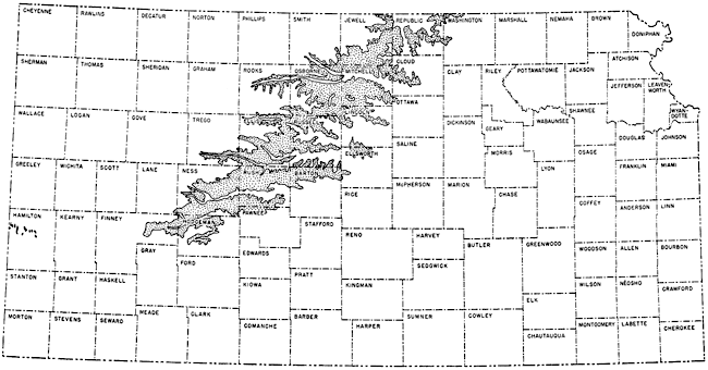
In Kansas, the Carlile Shale crops out in two areas of greatly different geographic extent. The larger area of outcrop is a belt that occupies part of 21 Kansas counties and that trends approximately southwest from the southernmost part of central Nebraska to Finney and Ford counties in southwestern Kansas (Fig. 1). The maximum length of this area, hereafter referred to as the west-central Kansas outcrop, is more than 200 miles, and its maximum width in an east-west direction, parallel to major stream valleys, is about 100 miles. A very much smaller area of exposed Carlile is located in northwestern Hamilton County, near the Colorado-Kansas border, where the formation may be seen in 13 small outcrops north of the Arkansas River valley.
Fig. 1--Map showing outcrop of Carlile Shale in Kansas.
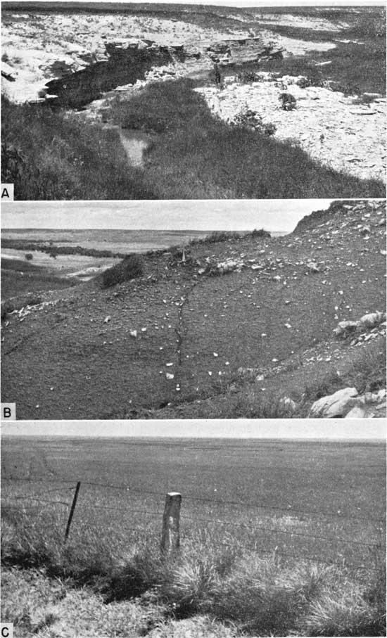
The best exposed sections of Carlile Shale in west-central Kansas are found along White Rock Creek in Jewell County, in the Blue Hills (sensu stricto) of Mitchell County and neighboring hills of eastern Osborne County, along the north and south forks of Solomon River in Smith and Osborne counties, along Saline River in northern Ellis County, along Smoky Hill River of southern Ellis and Trego counties, along Walnut Creek in Ness and Rush counties, and along Pawnee Creek in Finney and Hodgeman counties. Some sections were measured in tributary valleys of these main streams, but nearly all the best exposures are close to major east-trending valleys. Most good exposures of the Fairport Member are located along streams or in gullies close to streams (Pl. 2A). The Blue Hill Member is generally exposed on washed slopes or in gullies along the Fort Hays escarpment (Pl. 2B). In most of the eastern counties of the west-central Kansas outcrop, the Carlile forms only a thin veneer on a rolling upland surface, and good exposures are rare (Pl. 2C).
Plate 2--Topographic expression of Fairport and Blue Hill Members. A, Typical exposure of lower Fairport strata, sec. 22, T. 19 S., R. 23 W., Ness County (Loc. 22). B, Typical exposure of Blue Hill Member in bluff of Fort Hays escarpment, sec. 29, T. 11 S., R. 16 W., Ellis County (Loc. 25). C, Upland developed on lower Fairport strata, sec. 16, T. 13 S., R. 15 W., Russell County.
Hamilton County exposures of the Carlile Shale are generally poor, and no complete section is known, excepting a composite one that includes a water-well log (Bass, 1926, p. 63). Nonetheless, a few excellent exposures of parts of the Carlile lie along small tributaries of Arkansas River. Topographic relief in this area is much less than relief farther east, and exposures nowhere show the full thickness of either the Fairport or Blue Hill Member.
Upland surfaces throughout both outcrop areas are devoted mostly to the growing of wheat. The hilly walls of major stream valleys and the hills of escarpments on the east and west edges of the west-central outcrop are devoted almost exclusively to cattle ranching. Oil is produced locally in the west-central outcrop area, particularly in Ellis and Russell counties.
Several bulletins of the Kansas Geological Survey describe groundwater conditions in counties in which the Carlile Shale crops out, although the Carlile itself is not an aquifer.
General geology
Stratigraphic units under consideration are classed in the Colorado Group by Jewett (1959), who included therein the following formal units:
| Colorado Group | |||
| Niobrara Chalk | |||
| Smoky Hill Chalk Member | |||
| Fort Hays Limestone Member | |||
| Carlile Shale | |||
| Codell Sandstone Member | |||
| Blue Hill Shale Member | |||
| Fairport Chalk Member | |||
| Greenhorn Limestone | |||
| Pfeifer Shale Member, including | |||
| Fencepost limestone bed at top | |||
| Jetmore Chalk Member | |||
| Hartland Shale Member | |||
| Lincoln Limestone Member | |||
| Graneros Shale | |||
In normal sequence, the Niobrara Chalk overlies the Carlile Shale, but locally, as in Finney, Hodgeman, and Republic counties, the Ogallala Formation (Pliocene) rests disconformably on the Carlile. The northern part of the west-central outcrop is mantled locally by Pleistocene deposits.
Regional dip on top of the Dakota Formation is approximately 12 feet per mile toward the northeast from Hamilton County to Phillips County, Kansas (Merriam, 1957). In the west-central Kansas outcrop area of the Carlile, however, dip on top of the Dakota is generally northward at about 7 or 8 feet per mile. The regional dip at the base of the Niobrara from central Hamilton County to northeastern Phillips County is approximately 10 feet per mile as determined from a map prepared by Morrow (1941, fig. 7). The slope is far from uniform, however, because several major anticlines and synclines of the Kansas Great Plains involve Cretaceous strata (Merriam, 19,58, p. 93), and many local flexures and small-scale normal faults are recorded. Two small normal faults not reported previously were discovered in the Fairport Member: one near locality 27 in the SE sec. 18, T. 15 S., R. 19 W., Ellis County, and the other at locality 37, in Osborne County.
More resistant formations of the Colorado Group form prominent east-facing escarpments that dominate local topography of the west-central Kansas area. The Carlile Shale, which crops out in the western half of the Smoky Hills Section of the Great Plains, lies between two such escarpments. An intricately eroded escarpment in upper Greenhorn strata marks the eastern boundary of the Carlile belt, and a more conspicuous escarpment, capped by the relatively resistant Fort Hays Limestone Member of the Niobrara Chalk, forms the western edge (Pl. 3A).
Areas of greatest relief in the west-central Kansas Carlile outcrop are along the valley walls of major east-flowing streams, and at many such places Carlile strata are excellently exposed. Local relief along the Fort Hays escarpment is commonly 200 to 300 feet.
Breadth of outcrop in the west-central Kansas belt of Carlile Shale is governed almost wholly by topography rather than by differences in stratigraphic thickness or changes in dip. Thus, in areas of considerable relief, for example, in northeastern Ellis County along Saline River, the outcrop is as little as 1 mile wide. In contrast, interstream local relief is generally very small, and there the width of outcrop may be measured in tens of miles. Exposed sections in such areas are commonly small, difficult to locate, poorly exposed, and deeply weathered, and the surface on the Carlile Shale is a gently rolling upland plain. Except for thin chalky limestones near the base and layers of septarian concretions in the upper half, the Carlile offers little resistance to erosion. In many areas, the formation has been laid bare by slope-eroding processes, and miniature badlands may be observed locally in both the Fairport and Blue Hill Members.
Procedure
Exposures of the Carlile Shale were located by reference to published works and by systematic traverse of the outcrop belt as shown on the Geologic Map of Kansas (Moore and Landes, 1937), geological maps in various county reports of the Kansas Geological Survey, maps in construction-materials circulars of the U. S. Geological Survey, and State Highway Commission county plat maps. The locations of a few exposures were acquired orally from persons familiar with the area.
Sections were measured with a hand level and stadia rod, and with a steel tape. Use of a rod with the hand level greatly increased the accuracy of measurements, especially on grass-covered slopes. Total thicknesses of vertically extensive sections were checked by means of alidade and stadia rod. Most measurements are given to the nearest tenth of a foot, but many thin to very thin units, such as chalky limestones, marly chalks, and bentonites, are measured to the nearest hundredth of a foot. Precise measurements of thin beds have proved very useful as an aid in tracing persistent layers of rock. Concretions in the Blue Hill Member are commonly poorly preserved or only partly exposed, and dimensions of these, either stated or depicted graphically, are given to the nearest half-foot. Each measured section is divided into sedimentation units of uniform lithology, limited vertically by changes that are detected readily in the field.
Units thus distinguished were described separately, and lithology, thickness, fresh and weathered color, degree of induration, calcareous nature, fossils, secondary minerals, and structures were recorded. Colors were determined from the rock-color chart prepared by Goddard and others (1948). Sections were ditched with an ordinary trench pick wherever grass, soil, or slumped rock had covered otherwise continuous exposures. All contacts between members and between Carlile and adjacent formations were ditched so as to expose fresh rock.
Paleontological collections were made at nearly all places where invertebrate fossils are well preserved; however, the collections are only representative, because no attempt was made to collect all fossil materials available at any particular locality. Many fossils consist of fragile molds or partly weathered shells and must receive special field handling. Such specimens were dried briefly and then coated with a solution of alvar and acetone. All small specimens, including those not coated with preservative, were rolled in a thick wrapping of tissue paper, loosely bundled in more tissue paper, and placed in labelled sacks. Numerous representative hand specimens and shale samples were collected for laboratory analysis.
Laboratory study included examination of hand specimens and crushed samples under the binocular microscope, examination of micrograined and cryptograined constituents under very high magnification, and petrographic examination of thin sections. Representative thin sections were photographed. X-ray analyses were made of chalky shales, marly chalks, clay shales, bentonites, clay-ironstone concretions, a shaly chalk, and a sandstone. Chemical analyses of samples representing each of the major rock types of the three Carlile members followed standard procedure. For each of the three dominant rock varieties in the Fairport Member, insoluble residues were obtained by use of a 5-percent solution of technical grade HCl and distilled water for study of sand-size residue fractions and by use of a 20-percent solution for determination of total residue.
In the following text, some terms are used that could be misinterpreted, owing to wide range in usage by other workers, and these terms are explained below. Bedding terminology is that cited by Dunbar and Rodgers (1957, p. 97). Grain sizes mentioned in field and microscopic descriptions are based on the following scale: coarse grained, larger than 0.5 mm; medium grained, 0.25 to 0.5 mm; fine grained, 0.125 to 0.25 mm; very fine grained, 0.062 to 0.125 mm; micrograined or microcrystalline, grains less than 0.125 mm but visible under a petrographic microscope at 100x; cryptograined, grains too small to be distinguished under a petrographic microscope. The term "biofragmental" is used to describe rocks composed chiefly of fossil fragments. Colors, for all descriptions, are given for wet samples. The color-code designation appears in parentheses after names for which two colors are shown in the National Research Council Color Chart.
Acknowledgments
It is my pleasure to thank Dr. John Imbrie, Columbia University, under whose direction I completed a master's thesis on the Carlile invertebrates at The University of Kansas in 1952. I also thank Dr. T. Matsumoto, Kyushu University, Japan, for opportunity to discuss with him, in 1957, the identification of some of the Carlile species. I wish to express special appreciation to my wife, Marjorie, who accompanied me in the field in 1951, helped to gather a large part of the fossil collections, and has been of assistance in many ways during preparation of the manuscript. My appreciation is extended to Dr. W. A. Cobban, U. S. Geological Survey, for extensive discussion of the Carlile fauna and for permission to examine invertebrate fossils collected by him from Upper Cretaceous rocks of the Western Interior. Also acknowledged are Mr. George F. Sternberg and Mr. Myrl V. Walker, of the Fort Hays Kansas State College, for discussion of Carlile fossils with me and for directing me to several fine collecting localities, and Mr. Alex Richards, of Hays, who made known to and discussed with me the Osborne County locality where Blue Hill ripple marks and wall-like concretionary masses are exposed. Mr. James Pivonka, formerly a student at The University of Kansas, deserves much thanks for providing information regarding hard-to-find Fairport exposures in Rush County and for donating many excellent Fairport fossil specimens from his personal collection. I am deeply indebted to Indiana University students, Mr. Barry Haff and Mr. Richard Schumann, who accompanied me in the field in 1959; Mr. Craig Hatfield and Miss Judith Clark, who accompanied me in 1960; and Dr. Don Englehardt, who identified the plant remains. I am grateful to Dr. Carl Beek, Dr. John Droste, and Mr. S. Chaudhuri, all of Indiana University, for aid in x-ray determinations of Carlile minerals. Special thanks are due the following staff members of the Department of Geology, Indiana University: Mr. Maynard Coller, for preparation of chemical analyses; Mr. Leonard Neal, for preparation of most of the thin sections; Messrs. William Moran and Micky Love, for final drafting of line drawings; and Mrs. Joan Justus, for preparation of rough and final draft copies of the typescript. Photographs of fossils, hand specimens, and thin sections were prepared by Mr. George Ringer, Indiana Geological Survey, and to him I extend my gratitude. Lastly, but most of all, I extend sincerest appreciation to Dr. D. F. Merriam, State Geological Survey of Kansas, for advice in the field, laboratory, and office, for making many necessary arrangements with regard to the field work, and for the encouragement that has been, in large measure, responsible for the completion of this work.
Prev Page--Contents || Next Page--Stratigraphy 1
Kansas Geological Survey, Geology
Placed on web March 11, 2010; originally published May 1962.
Comments to webadmin@kgs.ku.edu
The URL for this page is http://www.kgs.ku.edu/Publications/Bulletins/156/02_intro.html