![]()
Prev Page--Introduction || Next Page--Resources
Geology of Kansas
To comprehend the main features connected with the mineral deposits of Kansas, an understanding of the state's geologic setting is essential. Accordingly a brief description of the main rock divisions and major structural elements found in this region is offered.
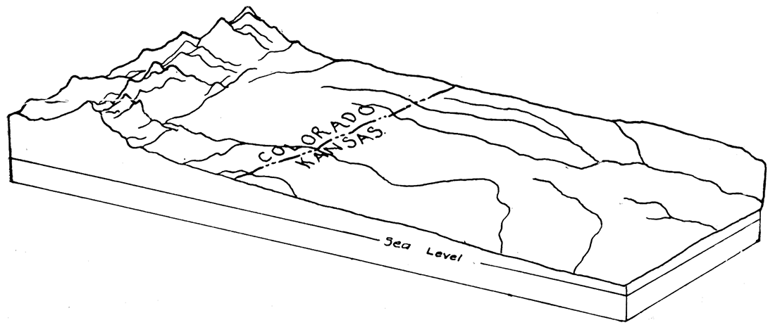
In its broad outlines the geology of Kansas is almost ideally simple. The state is a very typical part of the Great Plains region, which extends from the Dakotas to Texas and from the Rocky Mountains eastward to the Mississippi, and it has the uniformly gentle slope and simplicity of geologic structure which characterize the plains. The surface of Kansas has a general inclination from west to east, amounting to about ten feet per mile, the elevation of the western state boundary being about 3,500 to 4,000 feet, that of the eastern boundary from 750 to 1,000 feet. (Figure 3) The rock formations of which this sloping plane is built lie almost flat, and are exposed in broad north-south bands across the state. In reality they sag slightly in central Kansas, the rock slope or dip being toward the west in the eastern counties and to the east in the western part of the state. The oldest beds appear at the surface in the east and dip beneath the younger overlying formations which appear in succession as the state is crossed to the west.
Figure 3—Sketch diagram showing the east sloping plain east of the Rocky Mountains in Kansas and eastern Colorado.
The rocks of Kansas, as classified on the basis of origin, belong to the sedimentary group. Rocks of igneous origin have been found in deep wells, but excepting two very small areas, in Riley and Woodson counties, do not come to the surface within the borders of the state.
Sedimentary rocks are those composed of the transported fragments or particles of older rocks that have undergone disintegration. The chief agencies of transportation are water (including rain, streams, lakes and the sea), wind and glaciers. Deposition of the rock particles may take place along streams, at the bottom of lakes or the sea, where the wind drops its load, or beneath glaciers. Materials such as gravel, sand and clay are carried as solid particles, and after deposition may be consolidated to form conglomerate, sandstone or shale. Other materials are carried in solution and may be deposited chemically, as in the formation of salt or gypsum, or by the action of plants or animals, as in the formation of limestone or coal. Sedimentary rocks are usually made up of layers or beds, called strata, which can easily be separated.
By far the most important area of deposition in which sedimentary rocks are being formed is the bottom of the ocean. The bottom of the sea. is covered with gravel, sand and mud, which are sorted and spread by the waves and currents. As these sediments gather they bury others already deposited. When compressed by the weight of overlying materials, and bound together by cement deposited between the grains, the originally unconsolidated sediments are hardened into firm rock.
Older Rocks
Pre-Cambrian
The rocks in the general region of Kansas range in geologic age from almost the oldest known to the youngest. The oldest rocks are granites and other crystalline rocks of probable Archeozoic age which are exposed in the southeastern part of Missouri, in the Arbuckle and Wichita mountains of Oklahoma, in the Rocky Mountains of Colorado, and at points farther distant, north of Kansas. Since the exact age of these isolated patches of very ancient rocks is difficult or impossible to determine, it is most convenient to speak of them simply as pre-Cambrian, for in all cases they are known to be older than the first sedimentary rocks of the Paleozoic. It is known that the pre-Cambrian rocks extend everywhere beneath the later sedimentary formations, since they have been encountered in deep wells at many points outside the area of their outcrop. Geologic study indicates that any well drilled to a sufficient depth should strike the pre-Cambrian; that is, that these crystalline rocks represent a "fundamental basement" or floor on which all the succeeding stratified rocks of the continent are laid down.
The pre-Cambrian nowhere appears at the surface in Kansas, but drilling in the central part of the state has shown that it approaches the surface much more closely than was supposed. Sufficient tests have been made to indicate clearly the presence of a buried ridge or mountain range of granite which appears to trend in a direction slightly east of north from east Sumner county to the northern limits of the state. No evidence of metamorphism of the sedimentary rocks immediately overlying the granite has been found; and it is probable that the ridge represents a part of the pre-Cambrian floor.
Cambrian and Ordovician
The sedimentary formation which rest upon the pre-Cambrian floor conform essentially to its surface. They are nearly horizontal over wide areas where the underlying crystalline rocks have not been deformed, but are upturned where the granite has been pushed more or less sharply upward by deep-seated mountain-making forces. Thus where the granites appear at the surface in Missouri, Oklahoma, Colorado or South Dakota, the oldest sedimentary rocks are upturned around them, the younger formations appearing, in the order of their age, farther away. The exposure of these lower Paleozoic formations, even at a distance from Kansas, makes possible a more accurate conception of their character within the state than would be obtained from the record of deep borings alone.
As studied in the Ozark region of Missouri, the rocks beneath the Mississippian and overlying the pre-Cambrian include representatives of each of the geologic time divisions of the Paleozoic. The Cambrian and Ordovician systems of this region, consisting of dolomites, limestones, shales and sandstones, aggregate 2,000 to 2,500 feet in thickness. The succeeding Silurian and Devonian, however, are very thin and irregular in distribution and are practically confined to the northern, eastern and southern flanks of the Ozark uplift. The Silurian has been recognized in northeastern Oklahoma and northern Arkansas, but beds of this period and of the Devonian are wanting throughout most of the region of the Great Plains.
West of Kansas, in the upturned strata of the Front Range of the Rocky Mountains, the strata of the Great Plains are well exposed and may be studied in some detail. Here the Cambrian is observed in certain localities, but it has a thickness of not more than 50 or 60 feet, and for long distances it is absent altogether. The Ordovician, similarly, while recognized here and there, has a maximum thickness of only 250 feet, and disappears north of Denver.
Cambrian and Ordovician strata are present in the Wichita and Arbuckle mountains and surrounding the Black Hills of South Dakota. Since these old formations come to the surface at various points on almost all sides of Kansas, it may be supposed that they underlie most of the state, but it should be noted that their thickness decreases very greatly from east to west, as shown by observations in Missouri and Colorado. Deep borings in southeastern Kansas indicate the thickness of sedimentary rocks beneath the Mississippian in parts of the state to be more than 2,200 feet (Iola), although granite has been reported only 1,000 feet below the Mississippian at Paola and Neodesha (?).
If the granite of central Kansas already mentioned is pre-Cambrian, the older Paleozoic rocks are absent in this region, for the beds which immediately overlie the granite are apparently Pennsylvanian in age.
In summary, it appears that a series of dolomite, shale and sandstone formations belonging to the Cambrian and Ordovician systems, possibly with thin local deposits of Silurian or Devonian age, underlie most of Kansas. These beds are more than 2,000 feet thick in the eastern part of the state, but probably become very much thinner or locally absent to the west.
Mississippian System
Upon the eroded surface of the rocks of the older Paleozoic in the Great Plains country is found the Mississippian system, or, as it is generally called by oil drillers, the "Mississippi lime." The Mississippian is a clearly defined, readily traceable unit, consisting chiefly of crystalline limestone containing a rather unusual amount of hard, flinty chert. In Oklahoma and northern Arkansas it includes important beds of shale and some sandstone, but where encountered by the drill in Kansas and throughout most of Missouri it is essentially a limestone series. The thickness of the system in Kansas is not more than 300 or 350 feet.
The only portion of Kansas in which the Mississippian beds occur at the surface is a. small area in the southeastern portion of Cherokee county in the extreme southeastern corner of the state. The boundary between the Mississippian and the succeeding Pennsylvanian crosses the state line from Missouri about fifteen miles north of the southern border of the state and passes into Oklahoma about nine miles from the east Kansas state line. Deep wells at various points in Kansas northwest of the Mississippian outcrops above mentioned have encountered the limestone beds of the system. They show that the beds are gradually inclined in a west or northwest direction at a rate varying from 8 to 20 feet per mile.
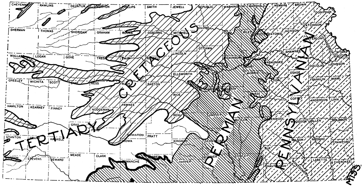
Figure 4—Geologic map of Kansas.
The Mississippian has been recognized definitely at points as far west as Harvey and Sumner counties, and it appears to have been encountered at great depth in the more-than-mile-deep wells of Clark and Hamilton counties. It is apparently absent along most of the line in which the wells have encountered the granite ridge in the east central portion of the state, in the Russell oil field, and in several other parts of central western Kansas. Mississippian rocks appear at the surface locally where the Paleozoic is upturned along the flanks of the Front Range in Colorado.
The upper surface of the Mississippian limestone is very uneven, having been greatly eroded during pre-Pennsylvanian and early Pennsylvanian time. As indicated by well drillings and observations in southeastern Kansas, the top of the Mississippian has a variation in elevation of as much as 75 to 90 feet in distances of less than one-half mile. This evidence of erosion has been observed throughout the Mississippi basin, and has been described by many geologists. It should be noted, however, that although there is considerable irregularity in the surface of the Mississippian limestone within a limited district, observations over a wider area show a general conformity between the bedding of the Mississippian and that of the overlying Pennsylvanian. This indicates that notwithstanding the widespread and possibly long-continued erosion after the Mississippian, there was no important disturbance of the older beds before Pennsylvanian deposition.
Pennsylvanian System
The Pennsylvanian system as observed in Kansas consists of a thick series of alternating shale and limestone formations, with irregular beds of sandstone and some beds of coal.
Pennsylvanian strata appear at the surface in a broad belt extending from northern Iowa to Texas, all of northwestern Missouri, southeastern Nebraska, the eastern one-fourth of Kansas and a large portion of Oklahoma and Arkansas being composed of these rocks. The Pennsylvanian of this region was at one time without doubt continuous with beds of the same age in Illinois and states farther east, and it. is probably directly continuous with the Pennsylvanian formations which come to the surface in the Front Range of the Rocky Mountains in Colorado. The system is of greatest economic importance because of the oil and gas contained in many of its more porous formations, and because of its deposits of coal, shale, clay and limestone.
The Pennsylvanian rocks of Kansas have a thickness, according to Haworth, of nearly 3,500 feet in the southern part of the state and a slightly smaller amount to the north. A total thickness of about 3,000 feet has been measured along Kansas river. As the Pennsylvanian rocks have a general dip to the west they are consequently much thinner along the eastern border of their outcrop, where only the older formations have been spared by erosion, and thickest in the counties adjoining the belt of Permian outcrop and farther west. However, borings in Russell county show that the maximum thickness of the Pennsylvanian rocks is about 1,300 feet, in Clark. county about 2,000 feet, and in Hamilton county about 1,400 feet. Since the dip of the beds is low and the relief of the surface slight, outcrops of the lower formations are separated by a distance of more than 100 miles from those of the upper. Accordingly, measurement of the thickness of the lower formations at their outcrop does not indicate precisely their thickness at points a considerable distance to the west, and compilation of surface measurements does not show accurately the total thickness of the system.
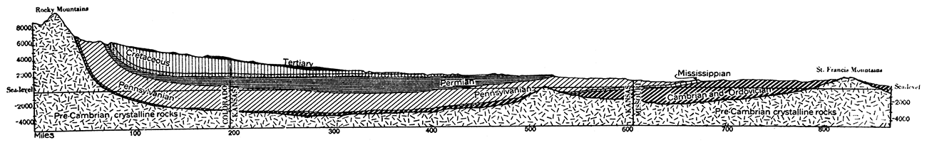
Figure 5—Geologic cross section in east-west direction across the Kansas region.
The Pennsylvanian system is composed of a number of varieties of shale, sandstone, limestone, clay and coal, which, though rather thin in a vertical direction, are unusually persistent horizontally. Many of the limestones have been traced from the north to the south border of the state, and in some cases a considerable distance into adjoining states.
From a quantitative standpoint, the shales are the most important of the rocks of the Pennsylvanian, constituting a considerable proportion of almost every formation. The shales are in general rather clayey. In many cases, however, they are quite sandy, and at many horizons grade both laterally and vertically into sandstone. Some of the shales are highly calcareous, in places containing so much lime that they might rather be called shaly limestones. The general color of the Pennsylvanian shale is gray or yellowish brown, but variegated tints of other colors are not uncommon. Dark or black slaty shales with abundant carbonaceous or bituminous matter also occur.
The limestones are probably next in importance in the Pennsylvanian of the region. They are for the greater part light-colored fossiliferous, fine-grained, compact rocks, many of the beds, especially the thicker ones, being also quite cherty. Some are oolitic and thick-bedded. The fragments of fossils of various sorts are extremely abundant in many formations, and in certain cases make up almost the entire body of the rocks. These include the more or less recognizable fragments of bryozoans, corals, shells of brachiopods and other invertebrates.
Sandstone is abundant at certain horizons, but, quantitatively considered, it is less important than the foregoing rock types. As a rule the sandstones are of medium grain and contain a great deal of mica. In a few instances they are coarse grained and non-micaceous. In color they vary from white to blue gray or yellow, but in almost all cases they weather to a yellowish brown. The sandstone formations are not very persistent horizontally, grading laterally as well as vertically into shales of more or less impervious character. The sandstones have a very great economic importance because of their content of oil and gas at very many places.
Coal is important in the lower divisions of the Pennsylvanian in Kansas, especially in the southeastern portion of the state. The coal beds of the Cherokee shale and of the overlying Marmaton formation are the most valuable. Clays are common in certain areas. They occur especially near the base of the Pennsylvanian associated with beds of coal.
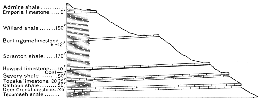
The lithologic character and the structure of the Pennsylvanian rocks of eastern Kansas are very closely reflected in the topography and physiography of the region. The limestone formations characteristically form more or less well-defined escarpments with steep eastern slopes, and very long, gentle dip slopes to the west, which. are traceable in some instances for miles. The escarpments made by the outcrops of these resistant formations may be followed with the greatest ease from one border of the state to the other, and have been mapped in some detail. Geologic cross sections drawn in various directions across the state have been prepared, a study of which shows the general relation of the formations to each other and to the surface outcrops.
Figure 6—Generalized section of the Des Moines group of the Pennsylvanian of Kansas.
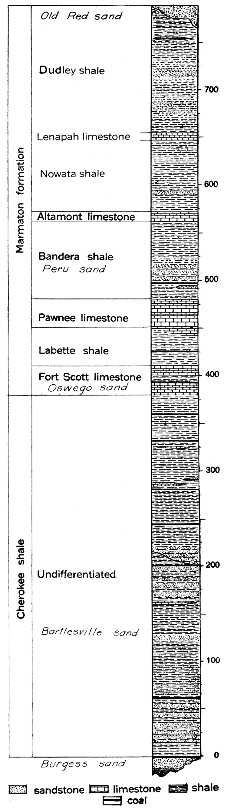
Figure 7—Generalized section of the Kansas City, Lansing, and Douglas formations of the Missouri group of the Pennsylvanian in Kansas.
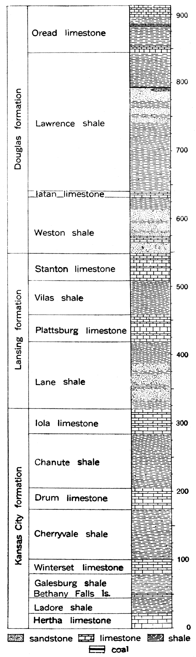
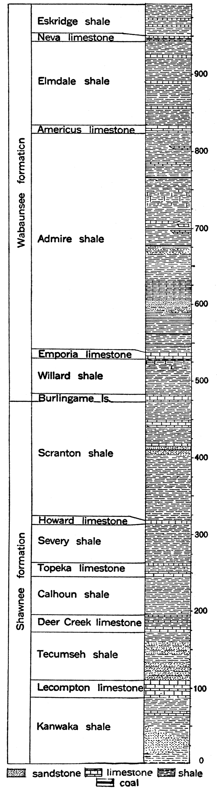
Figure 8—Generalized section of the Shawnee and Wabaunsee formations of the Missouri group of the Pennsylvanian in Kansas.
Structure
In common with the Mississippian and other systems outcropping in eastern Kansas and the adjoining region, the Pennsylvanian strata have a gentle inclination outward from the Ozark highlands. In eastern Kansas they dip in a direction slightly north of west. The Pennsylvanian extends beneath the overlying formations of Permian, Cretaceous and Tertiary age in the central and western part of Kansas, forming a shallow sag or syncline which characterizes the broader structure of the state. However, when examined in detail it is seen that there are many irregularities in the structure of the Pennsylvanian rocks. For example, at many points in eastern Kansas the rock strata are absolutely horizontal, or are even inclined to the east. These irregularities are minor waves on the major structure of the Pennsylvanian, and though not prominent, they are of importance to the oil producer, for they control in part the distribution of the oil and gas in the rocks.
Figure 9—Section showing the succession of rocks in the plateau south of Topeka, Kan.
Subdivisions
On the basis of difference in lithologic character and fossils, and to a certain extent on the evidence of erosion breaks at places in the series, the rock strata of the Pennsylvanian have been divided into a number of formations and members. The names used are those which appear to accord most closely with the established rules of nomenclature of geologic formations. A considerable amount of geologic work has been done in the region where the Pennsylvanian outcrops, and the subdivisions which have been recognized have been traced across most of the state. They may be accepted, therefore, as well-defined stratigraphic units.
| Divisions of the Pennsylvanian Rocks of Kansas | ||
|---|---|---|
| Group | Formation | Member |
| Missouri | Wabaunsee formation | Eskridge shale Neva limestone Elmdale shale Americus limestone Admire shale Emporia limestone Burlingame limestone |
| Shawnee formation | Scranton shale Howard limestone Severy shale Topeka limestone Calhoun shale Deer Creek limestone Tecumseh shale Lecompton limestone Kanwaka shale |
|
| Douglas formation | Oread limestone Lawrence shale Iatan limestone Weston shale |
|
| Lansing formation | Stanton limestone Vilas shale Plattsburg limestone Lane shale |
|
| Kansas City formation | Iola limestone Chanute shale Drum limestone Cherryvale shale Winterset limestone Galesburg shale Bethany Falls limestone Ladore shale Hertha limestone |
|
| Des Moines | Marmaton formation | Dudley shale Lenapah limestone Nowata shale Altamont limestone Bandera shale Pawnee limestone Labette shale Fort Scott limestone |
| Cherokee shale | Undifferentiated | |
Permian System
Distribution
Adjacent to the Pennsylvanian outcrops on the west, and occupying a zone in a north-south direction across central Kansas, is a group of rocks which are referred to the highest division of the Paleozoic era, the Permian period. This zone, narrow at the north where it is encroached from the west by the much younger beds of the Cretaceous, reaches its maximum width near the south border of the state, the Permian outcrop here extending from central Cowley county on the east to the west line of Clark county on the west. Thus the Permian of Kansas comprises a roughly triangular area with its apex at the north and its base on the south state line. (See geologic map.) In Oklahoma the Permian covers most of the western part of the state.
Thickness
It is difficult to make any definite or general statement with regard to the thickness of the Permian in Kansas. Of course, the cover of Permian rocks is thinnest near the eastern border of the Permian outcrop, where only the lowest divisions are present, and thickest near the Cretaceous boundary. It appears also that the Permian is very thin in the north and reaches a maximum thickness in Kansas toward the south, in Sumner and Harper counties. Wells drilled in Clark and Hamilton counties penetrated about 2,500 feet of red beds, salt, gypsum, limestone and shale which are assigned to the Permian. Observation of surface outcrops indicates an average total thickness of 1,100 feet for the lower non-red Permian and about 1,200 feet for the upper red-beds Permian.
Lithologic character
The Permian of Kansas includes two distinct divisions, a lower portion consisting of marine shale, limestone, salt, gypsum, and sandstone, lithologically very similar to the underlying Pennsylvanian, and an upper portion essentially composed of nonmarine red shales and sandstone. There are thick salt beds and some gypsum deposits in the upper part of the lower division (Figure 10), and extensive gypsum and some salt beds in the upper division. The marine limestones and shales are chiefly found in the northern and eastern part of the Permian outcrop, while the "red beds" are restricted to the southwestern part of the Permian area in the state. A short distance south of Kansas the non-red Permian limestones and shales disappear, being replaced by beds of red shale and sandstone. The red Permian rocks are therefore not entirely different in age from the non-red beds, though for the most part they are distinctly younger.
Figure 10—Generalized section of the Big Blue group of the Permian in Kansas.
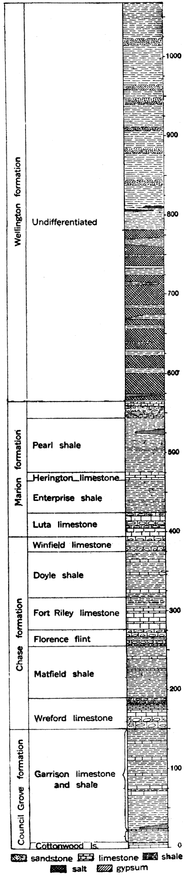
Figure 11—Generalized section of the Cimarron group of the Permian in Kansas.
The Permian limestones are essentially like those of the Pennsylvanian, with the exception that they are in general much more filled with chert. The chert is so abundant in some beds that they might well be called chert members rather than limestone members. The limestones are in most cases fine grained and noncrystalline. They are, like the limestone members of the Pennsylvanian, rather thin but strikingly persistent. In color they range from light gray or yellow to deep brown, and some of them are remarkably fossiliferous. The shale beds are quantitatively much the most important part of the lower Permian, comprising practically the whole of the formations where the limestones thin out. They are clayey rather than sandy, but grade locally into soft shaly sandstones. They vary in color from light gray, green or yellow to brown; and in a few cases reddish purple. The shales are not very fossiliferous as a rule, but some of the shale members are literally crowded with excellently preserved fossil shells. Sandstones are relatively unimportant and non-persistent. The salt beds are remarkably thick and pure in the upper part of the lower Permian, measuring about 400 feet in total thickness between Hutchinson and Kingman. The salt is in part interbedded with shale, but with little associated gypsum or limestone. The salt beds do not crop out in any part of the state, but have been recognized throughout a considerable area in deep drilling. Gypsum beds are of local occurrence and relatively slight thickness in the lower Permian. They are reported from horizons underlying the salt beds in north central Kansas.
The "red-beds" division of the Permian, as indicated by the name, is chiefly characterized by the red color of the formations, both shale and sandstone. Limestone is conspicuously lacking. The shales are slaty or sandy and grade laterally in many places into sandstone.. The sandstones, which are most commonly cross-bedded, are irregular in thickness and non-persistent. Gypsum beds appear to be the only fairly reliable stratigraphic markers, and where chiefly developed—in southern Kansas and Oklahoma—they have been used in the subdivision and mapping of the group. The red-beds gypsum of Kansas is best exposed in Clark, Comanche, and Barber counties. A thin member of dolomite is reported in the southwest part of the Permian outcrop in Kansas.
Subdivisions
The lower non-red division of the Permian is called the Big Blue group from typical development along the river of that name between Pottawatomie and Riley counties, Kansas. The red-beds division is included in the Cimarron group, the name being taken from Cimarron river, which crosses the outcrop of the beds in southwestern Kansas and northwestern Oklahoma.. The following table indicates the subdivisions of the Permian in Kansas as now defined:
| Subdivision of the Permian System in Kansas | ||
|---|---|---|
| Group | Formation | Member |
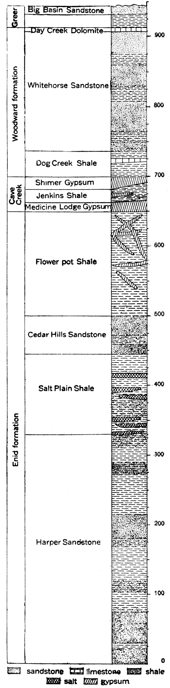
| Cimarron | Greer | Big Basin sandstone shale |
| Woodward | Day Creek dolomite White Horse sandstone Dog Creek shale |
|
| Cave Creek | Shimer gypsum Jenkins Shale Medicine Lodge gypsum |
|
| Enid | Flowerpot shale Cedar Hills sandstone Salt Plain shale Harper sandstone |
|
| Big Blue | Wellington | Undifferentiated |
| Marion | Pearl shale Herington limestone Enterprise shale Luta limestone |
|
| Chase | Winfield limestone Doyle shale Fort Riley limestone Florence flint Matfield shale Wreford limestone |
|
| Council Grove | Garrison shale and limestone Cottonwood limestone |
|
Comanchean (?) System
Appearing at the surface in Barber, Comanche, Kiowa, Clark and Meade counties, Kansas, and continuing thence in a southwesterly direction into Oklahoma, is a not very thick succession of sandstone and shale beds which by their contained fossils appear to represent part of the well-developed Comanchean (?) system of the Texas region. The belt of outcrop of these beds pursues an irregular westward course on the north side of Medicine Lodge river from a point a few miles northeast of the town of Medicine Lodge into southeastern Kiowa county, southeastward a considerable distance on the south side of Medicine Lodge river, then turns west. An outlier covering some square miles is found in southern Comanche county. The exact northward extent of the Comanchean (?) beds is undetermined on account of the widespread cover of younger strata, but fossiliferous beds of Comanchean (?) age occur in northern McPherson and Saline counties along Smoky Hill river.
Figure 12—Northern end of Gypsum hills. near Medicine Lodge, Barber county. showing typical badlands of the Permian red beds.
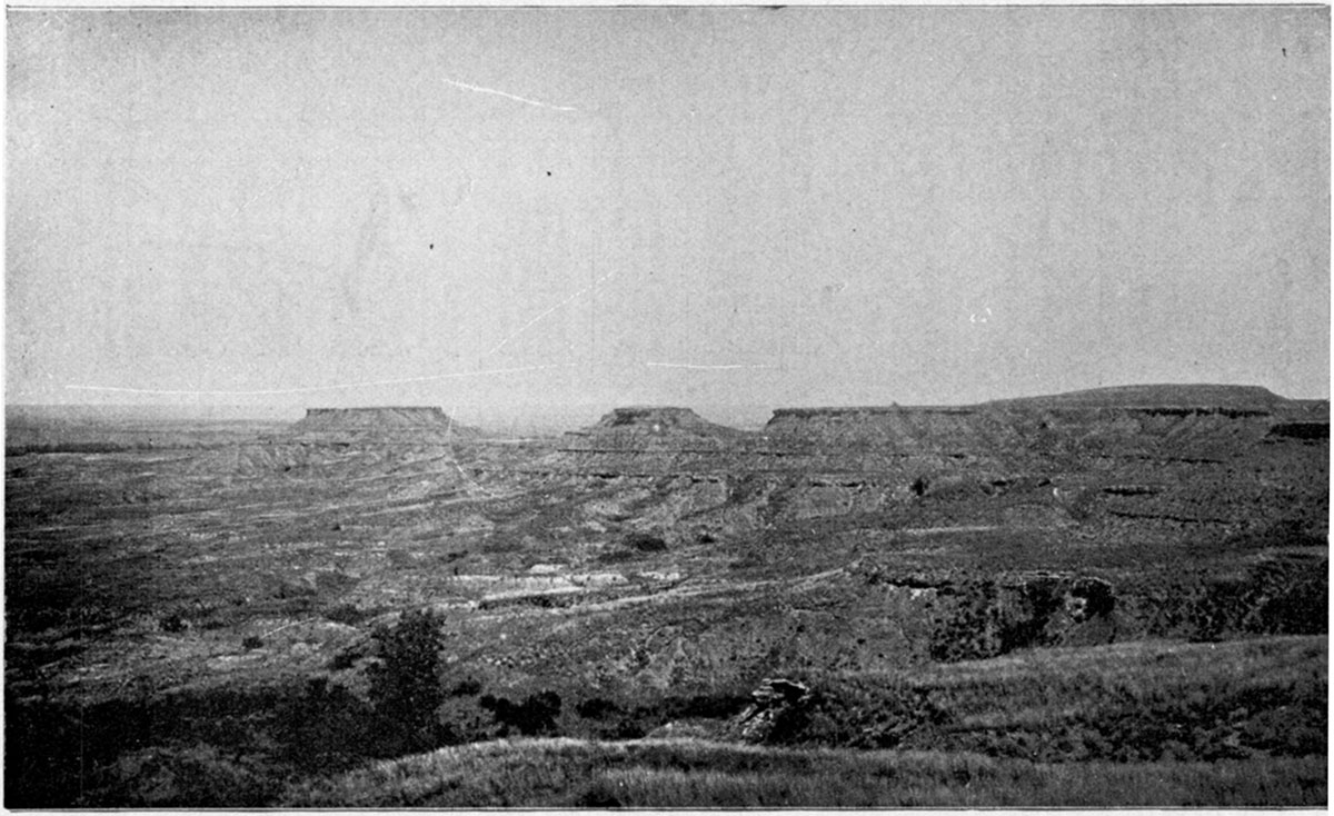
Figure 13—Generalized section of the Comanchean and Cretaceous systems in Kansas.
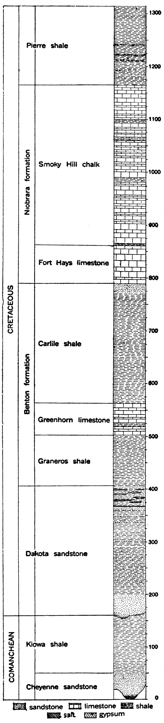
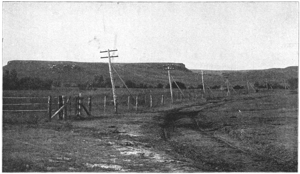
Figure 14—Dakota sandstone bluffs in eastern Ellsworth county, about six miles west of Brookville.
The Comanchean (?) of southwestern Kansas is composed of two formations, distinguished by lithologic and paleontologic characters. At the base, resting with distinctly marked unconformity on the eroded surface of the Permian red beds, is a sandstone which varies in thickness from 40 to 70 feet. This division has been called the Cheyenne sandstone. The upper division consists essentially of calcareous shale 125 to. 140 feet in thickness. In the eastern portion of the Comanchean (?) area is a shelly, fossiliferoUs limestone at the base of the shale. The formation is termed the Kiowa shale.
The total thickness of the Comanchean (?) beds as observed in southwestern Kansas is about 300 feet, and throughout. the greater portion of its extent the division has an average thickness of less than 200 feet. There is evidence from well records that the Comanchean (?) underlies much of western Kansas.
Cretaceous System
Distribution
Occupying an area of nearly 25,000 square miles in north central Kansas, and appearing at the surface in smaller tracts at various places in the western part of the state, are strata belonging to the Cretaceous system. The eastern boundary of the Cretaceous outcrop is a very irregular line trending southwest from Washington county to Reno county. Important outliers occur in Saline, Dickinson, Marion and McPherson counties. To the south and west the Cretaceous is concealed by a widespread mantle of Tertiary sands, gravels and other deposits. Along many of the streams, however, especially the main lines of drainage, the Tertiary cover has been removed by erosion, exposing the Cretaceous in long, narrow arms. Along Smoky Hill river, for example, Cretaceous strata are exposed to the west beyond the Colorado state line. The small areas of Cretaceous outcrops surrounded by Tertiary, which occur both to the north and south of the Smoky Hill, are found mainly where streams have cut through the overlying Tertiary.
Thickness
The maximum thickness of the Cretaceous rocks in Kansas is probably not more than 1,300 feet, but since the uppermost formation, the Pierre shale, is restricted to the northwestern portion of the state, it is certain that the thickness of the Cretaceous in the main area of its outcrop is very much less. In general, greater thicknesses are to be measured proceeding to the west; where successively higher divisions of the system are encountered. The thickness of the individual formations appears to remain fairly constant, so that measurements made at the outcrop closely approximate the record of thickness obtained from well-logs a hundred or more miles distant. The average thickness of the Cretaceous formations in Kansas is shown on the generalized section.
Lithologic character
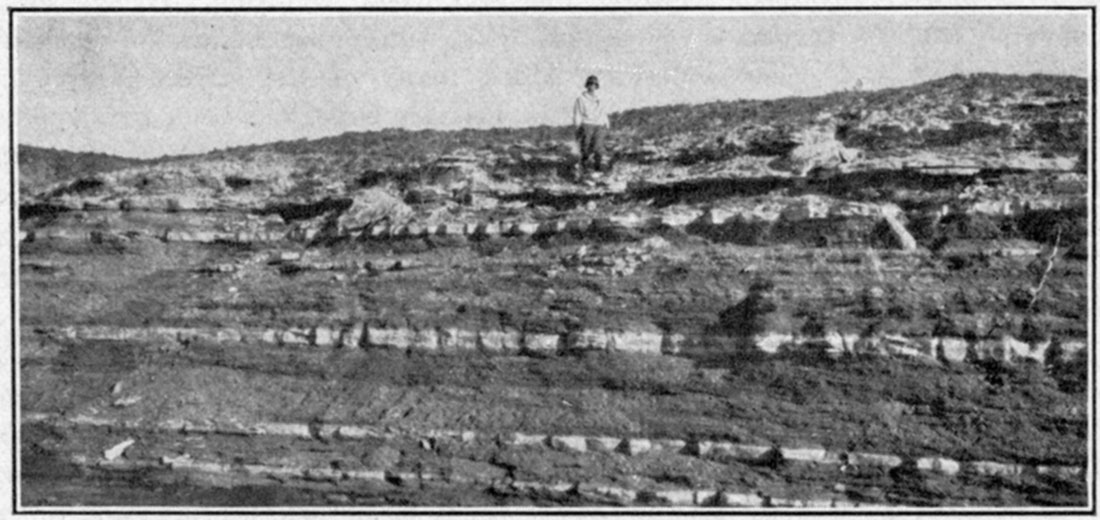
The Cretaceous system is composed of clayey and sandy shale, chalky limestone and sandstone, named in the order of their quantitative importance in the section.Figure 15—Niobrara chalk.
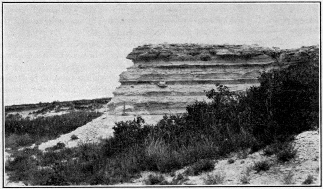
Figure 16—A part of the Bridge Creek limestone member of the Greenhorn limestone, east bank of Bridge creek, Hamilton county.
The shales are, for the most part, rather dark in color, ranging from dark blue-gray or brown to black. The "somber" color of some of the Cretaceous shale divisions is a characteristic feature throughout the entire northwest. Some of the shale beds are bituminous and contain thin beds of lignite. Light gray to almost white shales are well developed locally.
The limestone strata of the Cretaceous are in most cases characterized by their peculiar chalky texture. In some localities the rock is a pure chalk, white to light gray in color, and composed almost wholly of the microscopic remains of lime-shelled Foraminifera. From the purer varieties there is every gradation to chalky shale' or calcareous sandstone. Some of the limestone is hard and resistant, but in general it is much too soft for use in building. Colors observed include light blue, lavender, yellow, buff and light red. In a few places the chalky limestone beds contain concretions of flinty chert. A variety of other concretions are also observed.
The sandstone of the Cretaceous in Kansas belongs chiefly to the basal division, the Dakota. The Dakota sandstone is a coarse-grained, rather loosely cemented, massively bedded formation, gray to light or dark brown in color. As observed in many exposures it is very much cross-bedded. The chief cementing material is calcium carbonate, but iron oxide is also abundant, the content of iron being so great at some weathered exposures that the color is changed to a very dark brown and the weight of the rock is perceptibly increased. Where the rock is firmly cemented it is very hard and resistant, but other portions of the formation are soft and crumbling. As a rule the rock is very porous and presents most favorable conditions for the storage of underground water. Sandy beds, which occur higher in the system, as in the Carlile shale, are finer in their average texture and lighter colored than the Dakota.
Effect of topography
The topography of the Cretaceous area is essentially similar in many respects to that of the Pennsylvanian and Permian area farther east. The most prominent topographic features of eastern Kansas are the series of north-south escarpments formed by hard limestone members which alternate with soft, easily eroded shale members. In the area of Cretaceous outcrop there are also horizons which offer relatively great resistance to agencies of erosion and, as in the Pennsylvanian area, more or less prominent escarpments are formed. However, the Cretaceous escarpments are. in general less persistent and clearly defined. The divides between streams are rather characteristically broken up into buttes and isolated hills. The east margin of the Dakota sandstone is especially marked by rough craggy buttes. Shale areas in the Cretaceous belt, especially that of the Pierre shale, are marked in some districts by more or less numerous symmetrical "tepee buttes" hills of shale capped by large concretions or other resistant portions of the rocks.
Structure
As indicated in the structure-contour map (Figure 110), the general dip of the Cretaceous formations in Kansas is to the northeast. The dip is very gentle, amounting to an average of about 5 to 7 feet per mile, and appears to be constant for considerable distances. The Cretaceous of northwestern Kansas dips to the north and northwest, a broad, gentle anticline with a north-and-south-trending crest being found close to the line between Decatur and Norton counties.
Subdivisions
On the basis of lithologic character and fossils, the strata of the Cretaceous have been divided into a number of formations and members. The classification of the system as developed in Kansas agrees closely with that generally adopted in the Great Plains province.
| Subdivision of the Cretaceous System in Kansas | |
|---|---|
| Formation | Member |
| Pierre shale | Undifferentiated |
| Niobrara | Smoky Hill chalk Fort Hays limestone |
| Carlile shale | Blue Hill shale Fairport chalky shale |
| Greenhorn limestone | Pfeifer shale Jetmore chalk Hartland shale Lincoln limestone |
| Graneros shale | Undifferentiated |
| Dakota sandstone | Undifferentiated |
Tertiary and Later Deposits
The greatest part of western Kansas, comprising an area thousands of square miles in extent, is covered by a mantle of sand, gravel and limy clay which appears to have been deposited in late Tertiary time. This widespread Tertiary deposit forms the capping of the so-called high plains, and extends for great distances over eastern Colorado and western Kansas and Nebraska. The name Ogalalla formation, from a locality in southwestern Nebraska, has been adopted for this portion of the Tertiary.
The Ogalalla formation occupies all of the high plains of western Kansas. Its eastern boundary is a very irregular line trending southwestward from Jewell county to Finney county, thence eastward to Reno county, where it turns again to the southwest into Clark and Meade counties. The formation extends farthest east along the divides between the main streams. The larger rivers have cut through the Tertiary and carried away the sand and gravel from large areas. In some instances, notably the valley of Smoky Hill river, the Ogalalla has been removed for long distances; but in others, as along Cimarron river and tributaries in southwestern Kansas, it has been cut away only locally.
The materials of the Ogalalla formation are mainly sands, gravelly sands and gravels more or less cemented by carbonate of lime into a grit rock which in many cases has the appearance of rough mortar. On account of this resemblance, the name "mortar beds" has been rather widely applied to portions of the Kansas Tertiary. The deposits are in general calcareous, in some cases consisting mainly of lime carbonate and containing but little sand. In places the formation is a light colored sandy clay containing much carbonate of lime in streaks or nodules. The gravels found in the Ogalalla formation and derived by its weathering contain pebbles varying in size from 4 to 5 inches in diameter to coarse sand. They are composed of granite, syenite, porphyry, basalt and other igneous rocks,' and are evidently derived from areas of crystalline rocks to the west. Quartz pebbles are common. The sand is merely the finer material derived from the weathering of igneous rocks, but is largely a pure quartz sand. It exhibits various degrees of fineness, but when examined closely the grains are in almost all cases well rounded. Accumulations of small pockets of black magnetite sand are not uncommon in many parts of the Ogalalla. Clay beds are commonly white or pinkish and in some places form low steep banks or cliffs along the headwaters of streams. In a few localities, especially Norton and Phillips counties, beds of volcanic ash a number of feet in thickness occur. They are evidently related to similar deposits which have been found over a considerable area in Nebraska and Oklahoma. Volcanic ash does not constitute an important part of the Kansas Tertiary deposits.
The thickness of the Ogalalla formation in Kansas varies from practically nothing to more than 300 feet. Throughout the largest part of western Kansas it averages from 150 to 200 feet. In general the records of wells which have been drilled through the formation indicate that the greatest thicknesses are found on broad flat divides which have been little affected by erosion.
There are no well-defined stratigraphic horizons in the Kansas Tertiary which can be traced over considerable areas in an investigation of the structure of these beds. Prominent "mortar beds," which are well developed in some regions, cannot be traced with sufficient accuracy or to a sufficient distance to be of great service. Also, these distinctive portions of the Tertiary are found at the base, in the middle or at the summit of the formations in different localities. Since, however, a very large portion of the area underlain by the Ogalalla is an almost featureless plain, it is in general very difficult to determine in any satisfactory way the structural relations of the Tertiary.
Numerous fossil remains which have been found in the Ogalalla formation in Kansas indicate that it should be referred to the Miocene-Pliocene epoch of Tertiary time, and the deposits are so correlated by Darton.
Deposits made during the Glacial epoch and in recent geologic time are found in various parts of the state. In some cases these deposits only partially obscure the structure of the subjacent rocks, but in others they conceal it entirely. The deposits in Kansas, which are referred to the Quaternary, include (a) glacial deposits, (b) Pleistocene river deposits, (c) loess, (d) alluvium, and (e) sand hills;
(a) Glacial deposits
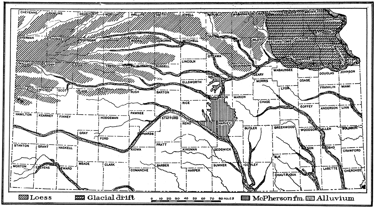
The former existence of a large glacier which advanced from the north and covered a large area in the northeastern portion of the state is evidenced by widespread deposits of glacial drift, bowlders and other glacial materials which entirely cover the region north of Kansas river and east of Washington and Riley counties. The glacial drift is a heterogeneous mixture of clay, sand, pebbles arid bowlders which is found on the hilltops as well as in the valleys. The, drift was deposited beneath and at the margin of the "Kansas ice sheet," one of the earliest of the continental glaciers, which during the Pleistocene covered enormous areas in the United States. The drift is very much weathered and thoroughly oxidized, so that the color due to the iron oxide content is in most cases a rich brown or red and the pebbles and bowlders are decayed and soft. Sufficient time has elapsed since the glaciation of northeastern Kansas to permit considerable. stream erosion. Lakes and swamps which are so numerous in recently glaciated districts are therefore absent, and the general appearance of the country resembles somewhat nonglaciated portions of the state. In some places the drift and other deposits made by the glacier have been removed by erosion, exposing the underlying hard rock strata, but for the greater part the mantle of glacial material effectually covers the underlying bed rock and obscures its structure. Lake deposits of glacial origin have been identified at various points along the margin of the Kansas glacier. The thickness of the glacial drift is on the average not greater than 6 to 10 feet, and in many places it is practically absent, but locally, as shown by well-borings, there are accumulations of more than 60 feet.
Figure 17—The Great Plains of western Kansas.
Figure 18—Typical outcrop of "mortar beds" of Ogalalla formation, Ellis county.
Figure 19—Outline map showing distribution of Quaternary deposits of Kansas.
(b) Pleistocene river deposits
During the Pleistocene, or Glacial, period considerable deposits of sand, sandy clay and alluvium were made in various stream valleys of the state. In some cases the material deposited may have been derived from the continental glacier to the north, but in large part the deposits were evidently obtained by normal erosion processes from the drainage basins of the streams themselves. Extensive deposits of this sort are found along the course of Arkansas river, Kansas river and tributaries.
One of the most interesting of the river deposits of Pleistocene time in Kansas is found in McPherson, Marion, Harvey and Reno counties. This deposit, which has been called the McPherson formation, is found in a broad channel, carved in the upper Permian shales and Dakota sandstone, and extending from Smoky Hill river at the north to Arkansas river in Sedgwick county. The area covered comprises practically the entire eastern half of McPherson county south of a line drawn from Lindsborg to Canton, all of Harvey county west of Newton, and most of eastern Reno county. The material composing the deposit consists of irregular layers of sand, clay and gravel, cemented loosely by carbonate of lime. The sand and gravel contain an abundance of water, and supply the water plants of neighboring cities. The thickness of the formation varies from a few feet to more than 100 feet.
(c) Loess
Covering a wide area of the high plains between the valleys of northern and northwestern Kansas is a smooth-surfaced, thick mantle of loess. The border of the loess-covered area trends eastward from Greeley county to Ellis county, thence northward to Osborne county and northeastward to Republic and Washington counties. There are also thick deposits of loess throughout northeastern Kansas in the district covered by the glacial drift. There are no sharp boundaries to the region of loess deposits because of the presence of the loess only on the uneroded uplands. In the west in few cases does it exceed a thickness of 30 to 40 feet, and on the average it is very much less, but in the northeastern counties of the state the thickness is in general much greater and some places near Missouri river the loess is more than 100 feet thick.
(d) Alluvium
There are many wide valleys in Kansas which are filled to various depths with deposits of alluvial material brought down by the streams. The largest and most extensive of these river deposits is that along the Arkansas river valley, which has a width of 6 to 10 miles and crosses a considerable part of the state. Other large streams, such as Kansas river and its tributaries to the west, Republican, Solomon, Saline and Smoky Hill rivers, have wide flood-plains composed of river-made alluvium. All the river and creek valleys contain more or less alluvial material of relatively recent origin, and most of the lower slopes of hills are covered by talus and slope-wash derived from recent weathering.
Figure 20—Map showing location of geologic sections A-H.
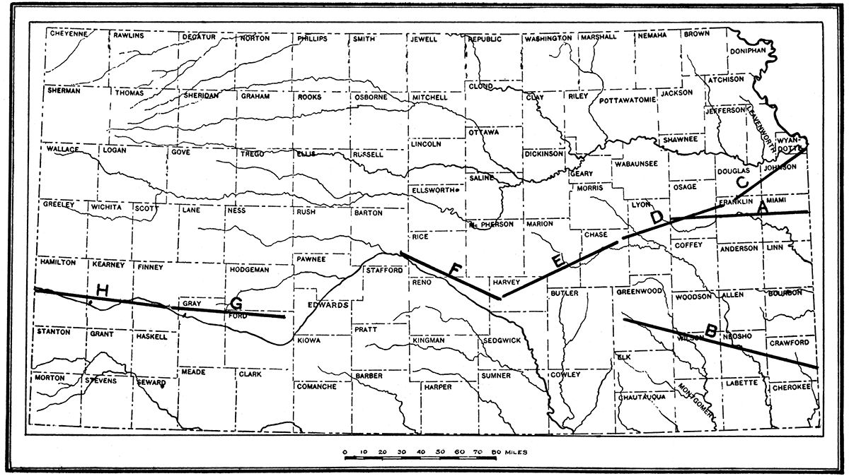
Figure 21—(A) Section showing the underground relations from state line east of Paola to a point 10 miles west of Osage City. (B) Section showing underground relation from state line east of Fort Scott to Burlington.
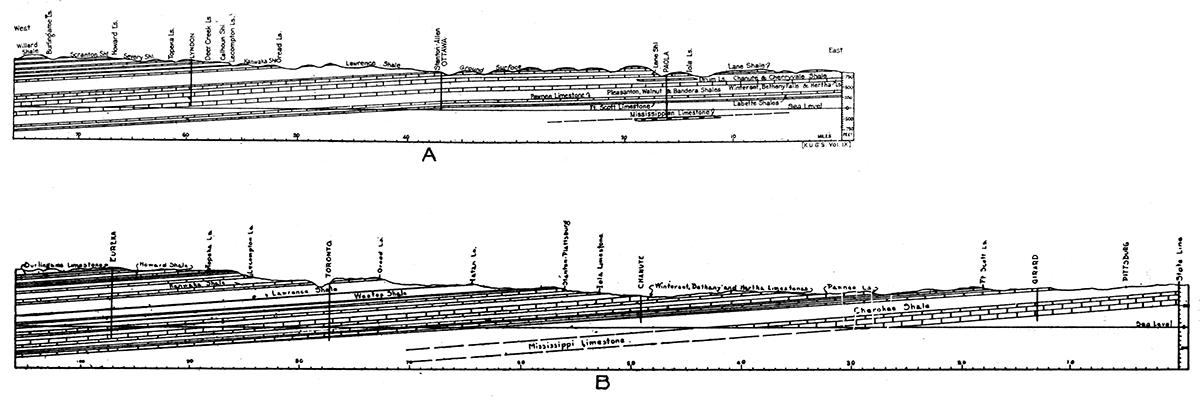
Figure 22—(C) Section from Kansas City through Olathe and Baldwin along line of old Santa Fe trail. (D) Section from Pomona to point west of Emporia. (E) Section from Strong City to Halstead.
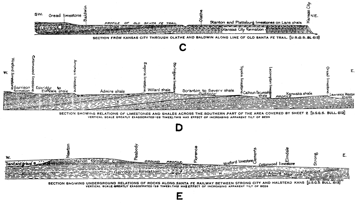
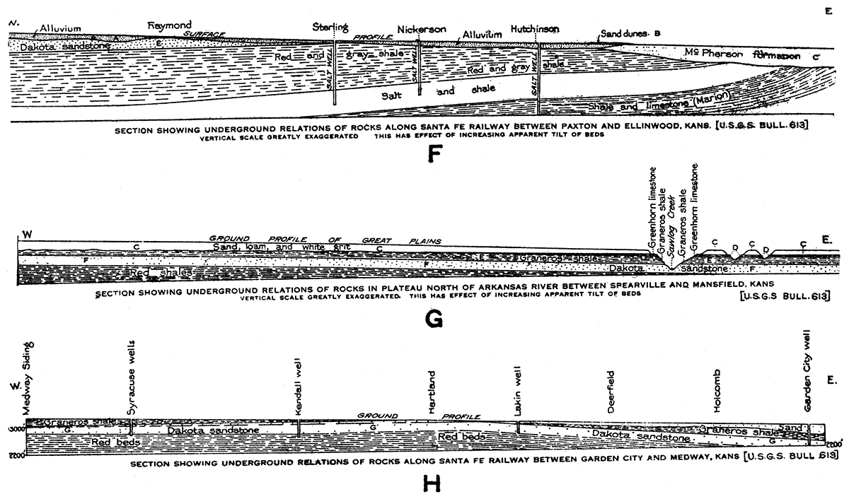
Figure 23—(F) Section from Paxton to Ellinwood. (G) Section from Spearville to Mansfield. (H) Section from Garden City to Medford.
(e) Sand dunes
A wide area in central Kansas, chiefly on the south side of Arkansas river, from Ford to Reno counties, is occupied by wind-blown sand. The sand constitutes hills and ridges of moderate height, with irregular basins and flats intervening. The sand has been derived chiefly from the alluvial fiats along Arkansas river, being blown out by the winds, which are prevailingly from the northwest. Indirectly, much of the sand comes from the weathering of Dakota sandstone and Tertiary deposits in the region. The dune sand effectually covers the bed rock and makes impossible any determination of the rock structure from surface evidence.
Prev Page--Introduction || Next Page--Resources
Kansas Geological Survey, Geology
Placed on web March 23, 2018; originally published November 1, 1927.
Comments to webadmin@kgs.ku.edu
The URL for this page is http://www.kgs.ku.edu/Publications/Bulletins/13/03_geol.html