![]()
Prev Page--Contents || Next Page--Previous Work
Introduction
Rocks of Desmoinesian age occurring below the Marmaton group in southeastern Kansas are those originally included within the Cherokee group of Haworth and Kirk (1894) and are classed as early and middle Desmoinesian in age. At an interstate conference held at Nevada, Missouri, March 31 and April 1, 1953, substage divisions were adopted for the Desmoinesian Series (Middle Pennsylvanian), and two group terms were introduced to replace the term Cherokee. Cherokee is retained, however, as an informal term for designating the generally clastic succession below the Marmaton group and above the Mississippian rocks in the northern Midcontinent. This inclusive term is useful in subsurface work where differentiation of beds is not sufficiently clear to allow identification of key beds in the succession, and was re-adopted for Kansas at a meeting in Lawrence on October 17, 1955, the Krebs and Cabaniss being relegated to subgroup status.
In southeastern Kansas the Cherokee includes a maximum of approximately 500 feet of sedimentary rocks characterized principally by the presence of numerous coal beds, thin limestone beds, relatively prominent sandstone and shale beds, and mostly inconspicuous underclays.
Economic resources associated with this succession include bituminous coal, raw materials for ceramic products, and petroleum. Knowledge of the stratigraphy is important, for it serves to guide production of these economic materials and study of their reserves.
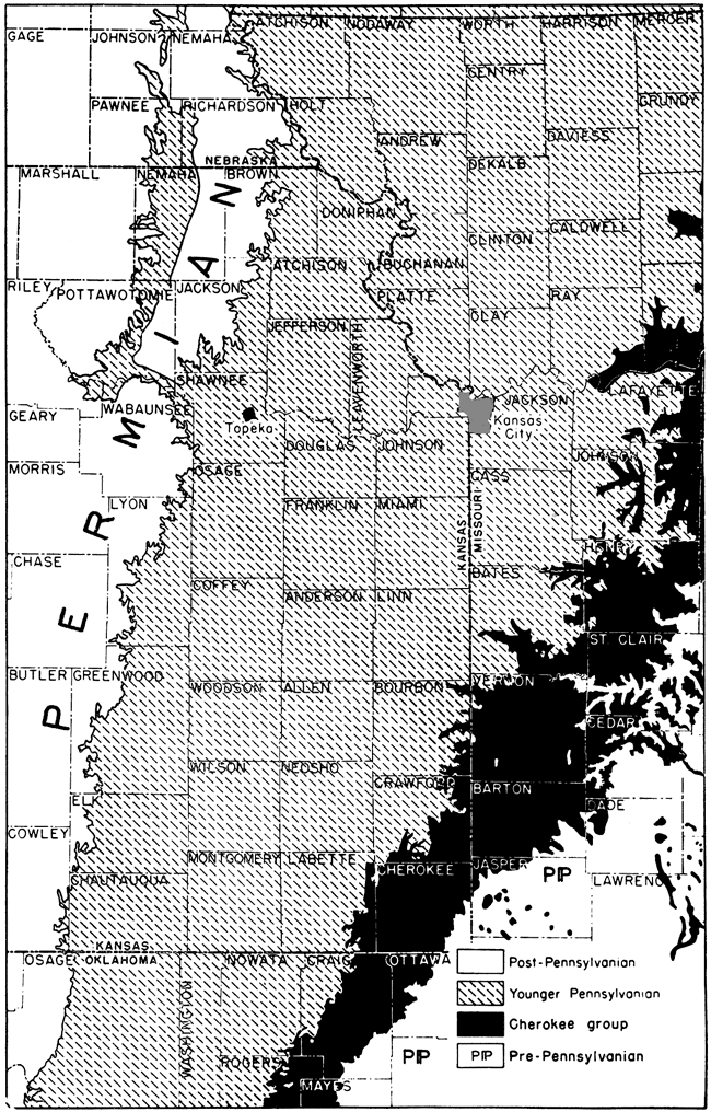
The area of exposure of the pre-Marmaton Desmoinesian rocks in southeastern Kansas is about 1,000 square miles, and includes parts of Labette, Cherokee, Crawford, and Bourbon counties. This, however, constitutes only a small portion of the area of continuous outcrop of strata of this age in the whole northern Midcontinent region (Fig. 1).
Figure 1--Area of outcrop (in black) of pre-Marmaton Desmoinesian beds in southeastern Kansas and adjacent areas in the northern Midcontinent region (from Moore, 1949).
Purpose and scope of investigation
The present investigation has as its prime purpose the detailed description of strata below the Marmaton group and above the Mississippian System in their outcrop area in southeastern Kansas, presenting this material in orderly succession according to a classification that seems most applicable to the included strata. The system of classification recently adopted for these beds by several state geological surveys (Searight and others, 1953) is followed with minor modification in this report.
Area and method of study
Information included in this report was derived principally from detailed study of exposures in the outcrop belt in southeastern Kansas. Cursory examination of portions of the succession in Missouri and in northern Oklahoma permitted determination of the lateral extent and variation of individual beds and regional correlation of major units. Secondary sources of information include numerous drill-hole records and early descriptions of outcrops that now are poorly exposed or inaccessible. Logs of coal prospect holes supply the most detailed subsurface information. Natural exposures of Cherokee strata are not abundant in the area, because of its generally low relief and presence of a widespread mantle of "gumbo clay" of Pleistocene age. They occur only along major streams and in areas of local relief, such as the Timbered Hills region in southern Cherokee County. Most stratigraphic sections used in preparing this report were described from artificial exposures made in strip-mining operations. Most of these open pits expose 20 to 30 feet, but a few reveal as much as 60 feet of strata. They are ideal for detailed study even though only parts of the succession in which strippable coals occur can be seen in the walls of the pits. Principally exposed are the Weir-Pittsburg coal and overlying beds, constituting approximately the upper one-half of the complete succession. Several sinkholes in the southeastern part of the area permit study of the basal Desmoinesian strata and show the contact with underlying Mississippian rocks.
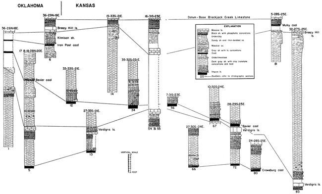
Correlation charts (Pl. 1 and Fig. 2, 3, and 4), compiled from described sections in the area, illustrate lateral variation in lithology and thickness of the succession. An appendix contains representative stratigraphic sections. Plate 2 illustrates the stratigraphic distribution of common fossils in Krebs and Cabaniss subgroups of the Cherokee group.
Figure 2--Detailed sections of Krebs beds in southeastern Kansas and western Missouri. A larger verison of this figure is available.
![Six sections in Upper Krebs [showing Neutral, Rowe, Dry Wood, and Bluejacket coals] and two in lower Krebs [showing Riverton coal].](gifs/fig2sm.gif)
Figure 3--Detailed sections of Lower Cabaniss beds in northern Oklahoma and southeastern Kansas. A larger verison of this figure is available.
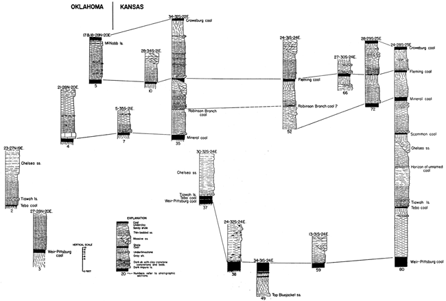
Figure 4--Detailed sections of Upper Cabaniss beds in northern Oklahoma and southeastern Kansas. A larger verison of this figure is available.
Acknowledgments
The present report was begun and completed under the auspices of the State Geological Survey of Kansas, and is a slightly modified form of a dissertation submitted as a partial requirement for the degree of Doctor of Philosophy at the University of Kansas. Field work was done in the summer field seasons of 1948, 1949, and 1950.
I am much indebted to officials of the Missouri Geological Survey for aid and consultation on geologic problems and for arrangements making it possible to complete writing of this report while in the employ of that organization.
Various members of the Oklahoma Geological Survey have given assistance in the solution of geologic problems in which both Kansas and Oklahoma areas are involved.
It is a pleasure to acknowledge the cooperation of mine operators and landowners within the area. In no case have they refused entry to mines or other property, and have given freely any information requested.
Prev Page--Contents || Next Page--Previous Work
Kansas Geological Survey, Geology
Placed on web May 25, 2009; originally published October 1956.
Comments to webadmin@kgs.ku.edu
The URL for this page is http://www.kgs.ku.edu/Publications/Bulletins/123/02_intro.html