![]()
Prev Page--Dakota Sandstone || Next Page--References
Part IV--Structure and Limits of the Kansas Salt Beds
Recent prospecting for oil and gas in western Kansas, stimulated by the discovery of the Russell County oil field, and numerous wells put down prior to this recent drilling campaign, have afforded information as to the lateral extent and thickness of the Kansas salt deposits. In general, the area underlain by thick salt beds extends westward from a north-south line drawn a little west of the center of Sumner, Sedgwick, Harvey, McPherson and Saline counties and thence northwestward to the north-central part of Mitchell County. The accompanying sketch maps (Pls. VIII and IX) show the boundary of the salt deposit as defined by the present information. Although future drilling will make revisions necessary in many places, wells drilled in Rooks, Phillips and Decatur counties subsequent to the preparation of the map encountered no salt, and so indicate that the salt beds do not extend much farther north than the boundary shown on Plates VIII and IX.
The most widely spread zone of salt occurs in the Wellington formation (unit 4, PI. II), of the Permian in Kansas. It is from this zone that commercial salt is produced at Hutchinson, Lyons, and Kanopolis. Throughout extensive areas the salt occurs in thick beds, and in other localities it is represented by thin layers intercalated with blue shale. A second deposit of salt about 200 feet thick a little more than 1,000 feet above the Wellington salt is shown by the logs of three wells in Clark County. (See Pl. VIII for location of wells.) It is to the presence of this upper salt that the greater part of the salt thickness in Clark, Meade, and Ford counties, shown on Plate VIII, is due. The principal salt recorded in the logs of the well in Hamilton County and in the well at Eads, Colo., about 30 miles west of the southwest corner of Greeley County, appears to represent more nearly the stratigraphic horizon of this upper salt, although it is probably not continuous throughout the region between Hamilton and Clark counties.
Plate VIII--Isopachus map showing thickness of salt in western Kansas. [An Acrobat PDF version of this figure is available.]
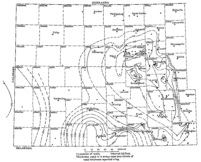
Plate IX--Attitude of top of salt beds of Wellington formation in western Kansas. [An Acrobat PDF version of this figure is available.]
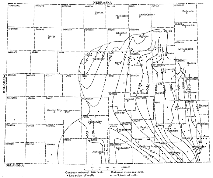
The structural attitude of the salt beds is shown on Plate IX by contours drawn on the top of the Wellington salt. These contours represent in general a board syncline, whose axis extends from southern Comanche County northward. The east limb of the syncline is relatively more steeply inclined at the eastern edge of the basin and has a tendency to flatten westward as it approaches the axis. The most prominent structural irregularity shown by the available information is the Fairport-Natoma anticline, on which the Russell oil field is located. This fold extends slightly east of north through the western edge of Russell County and into Osborne County. A northwestward anticlinal nose extends across Russell County and intersects the Fairport-Natoma anticline a little south of the northwest corner of the county. Altitudes determined in Kingman County indicate a westward-trending anticlinal nose in the northeastern part of the county, and an anticlinal nose alined in a northeasterly direction may be present in northeastern Clark County. Inasmuch as the presence of the two structural features just mentioned is inferred from data obtained from only a few wells, correspondingly less confidence can be placed in their existence and character. The irregularities shown in Russell and Ellsworth counties merely indicate that when more wells are drilled throughout western Kansas many changes can be made in the structural picture shown in Plate IX. In other words, smooth-flowing lines represent rather a lack of data than a true delineation of the actual structural conditions. As the meager data available indicate that the salt beds of the Wellington formation are absent in the westernmost four tiers of counties the general structure there can only be conjectured from other data. If the principal salt bed of the Wood Oil Co.'s Ranson No. 1 well, in the southern part of Hamilton County, is assumed to be at the stratigraphic horizon of the upper salt in the Clark County wells, these rocks are about 200 feet higher structurally in the Hamilton County well than in the Watchorn Oil & Gas Co.'s Morrison No. 1 well, in northeastern Clark County (the center one of the three shown in PI. IX).
The existence of possible structural relations of the Cambridge anticline (Pl. VII) ; the occurrence of gas at Liberal, near the southwest corner of Seward County; and the oil and gas producing area near Amarillo, Tex., about 90 miles southwest of Liberal, have been mentioned by Pratt (1923, p. 245).
A show of gas was also reported in a well drilled in northeastern Finney County, and shows of oil were struck in a well drilled in eastern Decatur County, both of which are on this regional trend. Thom (W. T. Thom, Jr., informal communication) has suggested that the thinning of the Wellington salt westward in Kansas toward this possible regional "high," and its actual absence over the "high," together with the presence of a salt zone in Clark and Hamilton counties and its absence in intervening territory (the logs of the Seward County wells show no salt), tend to strengthen the supposition that an axis of uplift in this part of southern Kansas and northern Oklahoma may have formed a barrier between the basins where salt deposition was in progress in Permian time. Anticlinal folds overlying the buried Nemaha ridge in central Kansas; the Fairport-Natoma anticline, that crosses Russell and Osborne counties, on which granite has been struck; and a suggested buried ridge in northeastern New Mexico underlying prominent surface folds, suggest a regional structural pattern into which this possible structural "high" extending from Texas to Nebraska may fit. This alinement suggests that it, too, may overlie a granite ridge.
Plate VIII is a map showing the total thickness of the salt in western Kansas, as determined from well logs. Two-thirds of the salt as reported in the logs was assumed to be the total thickness of pure salt. The remaining third was discarded to allow for shale partings and other impurities not noted in the logs. Plate VIII is believed to represent in the main a fair picture of the thickness of the salt deposits in the area, although drastic revision can undoubtedly be made in places when more wells are drilled, and even with the data now at hand the map is in part subject to question. For example, the well in northeastern Comanche County is the sole basis for showing the salt to be so thick in that county and southwestern Barber County. Salt and shale are reported in the log of this well throughout a thickness of 550 feet, so that the amount assumed to be salt in compiling Plate VIII may be too great. The representation of an area of thick salt centering in Clark County is in part misleading, inasmuch as the thicknesses used there are based on two-thirds of the combined thickness of two salt zones that are separated stratigraphically by about 1,000 feet of red rock, while the thicknesses used north and east of this area represent only the lower salt zone, the upper zone not being present. If only the lower zone in Clark County wells is considered, the thickness of pure salt in the three wells would be, from the southeastern well northwestward, 130 feet, 60 feet, and 110 feet (in each two-thirds of the reported thickness).
As an acre-foot of pure salt weight approximately 3,000 tons, the total amount of salt in the area shown on Plate VIII is probably more than 5 trillion tons. This salt built into a prism with its base covering Grant County, which is 24 miles square, would be a little less than 1 mile high. Or it would be sufficient to build a wall a little more than 2 miles wide and 1,000 feet high entirely around the state of Kansas, a linear distance of 1,150 miles. The amount of normal sea water that would have to evaporated in order to form this amount of salt may be inferred from the fact that a thickness of about 3 feet of salt is deposited from a body of sea water about 100 feet deep (Darton, 1921).
A study of the logs of wells drilled along the eastern margin uf the salt area indicates that in the past salt beds extended farther eastward and that the present eastern boundary is largely the edge left by the dissolving away of this eastern portion. Comparison of the records of wells drilled in northern Sumner County on both sides of the margin of the salt shows a marked constriction in the eastern wells of the interval occupied elsewhere by the salt. A similar condition is shown by wells drilled in Lincoln County. Near this eastern margin wells reporting the salt to be more than 200 feet thick are only a few miles west of wells showing no salt. This abrupt change in thickness indicates that the margin of the salt represents an edge resulting from something comparable to erosion, rather than the shore line of an original salt deposit. The constriction of the salt interval in the eastern wells makes it appear very probable that as a result of the leaching and carrying away of the readily soluble salt beds by circulating ground waters near the outcrop, the overlying shale beds settled downward and filled in the cavities. It should be expected that settling on as large a scale as is postulated would be manifest in the topography of the surface, and inspection of the topographic maps that cover the marginal area for the most part corroborates this assumption. A narrow stretch of low-lying land, dotted with marshes, swamps, and lakes, extends northward from northwestern Sedgwick County across Harvey and McPherson counties, practically coinciding with the boundary of the salt area as shown by well logs. The fact that many of these lakes are salty is further evidence that is considered corroborative of the explanation offered (R. C. Moore, personal communication). The series of lakes and swamps cited is not continuous southward across Sedgwick County, but this fact is not necessarily out of harmony with the reasoning developed, for the margin of the salt passes under the valley of Arkansas river, and the surface is largely occupied by alluvial fill and Tertiary deposits, which would have obliterated such features.
Other margins of the salt, however, indicate original shores. Wells showing no salt drilled in the vicinity of Wellington and south-westward in Sumner County do not show a constriction of the interval elsewhere occupied by the salt, but rather indicate that this interval has thickened slightly eastward, a relation that might be expected near shore where mud would very probably accumulate in greater thickness than farther out in the basin. The salt reported in wells in this part of the state shows a gradual thinning southeastward, almost certainly indicating an approach to the shore, in contrast to the abrupt termination noted along the east margin farther north. A like gradual thinning outward from the center is shown by wells in the northern and western part of the main salt area, indicating there an approach toward the shore of the depositional basin. These observations lead to the conclusion that the boundary of the salt 'beds as shown on Plate VIII represents the outer limit of salt deposition in southern Sumner County and along the northern and western boundaries, and that the eastern limit represents a position an unknown distance west of the original shore line. The recorded thicknesses indicate that the salt occurs chiefly in three rather distinct areas. One area lies in central Kansas and has its center near the western part of Rice County; another appears to lie chiefly in western Oklahoma, south of Clark County, Kansas, and a third is indicated in southeastern Colorado, west of Syracuse, Kan. (Darton, 1921). It seems probable that the latter two areas represent two different basins of salt accumulation or arms of one larger basin of later age than that centered near Rice County, the one south of Clark County overlapping the western edge of the Rice County basin.
The map of salt thicknesses (Pl. VIII) adds some data that tend to confirm W. D. Johnson's suggestion that the origin of the Cheyenne Bottoms, in central Barton County, may be attributed to settling resulting from the removal of soluble masses of salt within the underlying rock (Johnson, 1901, p. 712-713). Johnson accounted for the Meade Basin, in Meade County, similarly and cited examples of caving and the formation of sink holes that are of historic record, as illustrations of the process. In March, 1897, the surface of an area 175 feet in diameter which lay directly in the path of a cross-country trail near the margin of the Meade Basin slumped, and the hole thus formed filled with salt water (Johnson, 1901, p. 706-707). A similar phenomenon occurred in 1898 at the Rosel railroad station in western Pawnee County (Johnson, 1901, p. 712). Within a night an area of about an acre slumped, carrying down with it several station buildings and leaving in their place a lake surrounded by abrupt walls. No direct information is available on the thickness of the salt in Meade and Pawnee counties, but wells within the Cheyenne Bottoms show a marked thinning of the salt series as compared with logs of wells surrounding the area, suggesting that part of the original salt deposit may have been dissolved and carried away by circulating ground water.
The Kansas salt deposits constitute outliers of more extensive deposits in Texas and New Mexico where potash salts have recently been found associated with the salt beds--a fact which suggests that potash salts may exist in the Kansas deposits. Drillers of wells in this region are urged to collect samples from any salt beds penetrated. Inasmuch as most of the potash salts found in the Texas and New Mexico region are of pinkish or reddish color, it is particularly important to save any cuttings that contain red particles with the salt. [Note: Collecting sacks will be furnished upon application to the state geologist, Lawrence, Kan., and samples collected should be returned to the state geologist for chemical analysis.]
Note on Subsidence Near Sharon Springs, Wallace County, Kansas
By Raymond C. Moore
On March 9, 1926, a very interesting subsidence occurred on the south side of the Smoky Hill river valley along the line between sections 33 and 34, T. 13 S., R. 39 W., about 5 miles east of Sharon Springs, in Wallace County. Because of the suddenness of the subsidence and the considerable depth of the resulting hole, widespread publicity in the press attended the phenomenon. A detailed report is not in place here, but supplementing notes on subsidence by Mr. Bass, essential facts gathered by the state geologist in a recent examination at the Sharon Springs locality may be of interest.
The present dimensions of the basin formed by the subsidence are about 350 feet from east to west by 250 feet from north to south. At first the hole was much smaller, and it had a considerable but unmeasured depth, estimated by early visitors at 300 to 500 feet. Although Smoky Hill river is here dry, water from the underflow gradually filled the depression, forming a pond which, at the time of the writers' visit; was 75 feet below the adjacent upland to the east. Systematic soundings showed a gradual increase in depth of the water to about 50 feet, and then in the middle part of the depression a practically vertical-sided hole in which the depth of water was 165 to 170 feet. The computed volume of the depression is approximately 1 1/2 million cubic feet.
Pierre shale is exposed in the walls of the sink, and near by there are very good exposures of this formation. The overlying Niobrara chalk is exposed a short distance east of the sink, south of Wallace. The structural relationships of the Cretaceous rocks show that water entering the Niobrara in eastern Colorado throughout a large area northeast of Las Animas may be expected to migrate down the dip of this soluble arid more or less porous formation, emerging at the exposures 1,500 feet or more nearer sea level in Logan and other counties farther east in Kansas. It seems evident that the subsidence near Sharon Springs is due to the formation of a cavity of considerable size in the upper part of the chalk, following which, failure of the roof caused the cave-in.
The occurrence of crater-like depressions of varying size at several places in Wallace County under conditions that show clearly a depression of the Cretaceous rocks, the Tertiary being very thin or absent, indicates that solution of the chalk followed by subsidence of the overlying materials has taken place from time to time in the recent geologic history of the region.
Prev Page--Dakota Sandstone || Next Page--References
Kansas Geological Survey, Geology
Placed on web July 2, 2015; originally published April 1926.
Comments to webadmin@kgs.ku.edu
The URL for this page is http://www.kgs.ku.edu/Publications/Bulletins/11/05_salt.html