![]()
Prev Page--Hamilton County || Next Page--Salt Beds
Part III--Geologic Structure of the Dakota Sandstone of Western Kansas
Prospectors for new oil and gas pools are diligently at work in many localities in western Kansas. The Russell oil field, in northwestern Russell County, was discovered late in the fall of 1923, through their efforts, and is now producing about 5,000 barrels of high-grade oil a day, and many wells are being drilled in the field. Encouraging shows of oil or gas have been reported in wells drilled in no less than eighteen counties; oil has been produced a few miles north of Hutchinson; and gas has been found in a well now capped, at Liberal, near the southwest corner of the state, and in four wells about 15 miles south of Wray, Colo., within 5 miles of the west boundary of Kansas. Two wells in the western part of the state have gone. below a depth of 5,000 feet; one in Hamilton County was drilled to 5,488 feet, and one in Clark County had reached a depth of more than a mile by the end of 1925.
Many of the wells of western Kansas have been drilled subsequent to the compilation by Darton of a preliminary map of the central Great Plains, showing the structure of the Dakota sandstone, and these wells have made available additional structural data (Darton, 1918). The writer spent about three weeks in October and November, 1924, collecting many of these recently available data. Every County in western Kansas was visited, and drilled wells were located and their altitude determined by aneroid in much of the area, and by the topographic maps of the Geological Survey in the areas for which such maps were available. All outcrops of known key beds in the Cretaceous rocks that were seen along the route were sketched, and their altitude determined in the same manner as that of the wells. Reconnaissance structural data that were obtained earlier in the year in Russell County by W. W. Rubey and the writer and in Ellis and Hamilton counties by the writer are incorporated in the regional map. Information on file by oil companies operating in the region was used wherever available. The records of the Keys Petroleum Co., of Wakeeney, were of particular value, and the writer is glad of this opportunity to acknowledge the courtesies shown by this company and others, and by many individuals, too numerous to mention. It is regrettable that sufficient time to get records of all water wells was not available, and that much other work which should be done cannot be undertaken because of lack of state funds. Consequently, the structural features as shown might be modified somewhat by information from existing deep water wells, but it is believed that the map presents a sufficiently accurate regional picture of the structural conditions of western Kansas to justify its publication, although much improvement is no doubt possible.
Plate VII--Reconnaissance map of western Kansas showing structure of the Dakota sandstone. Errata: Top center of map in margin above Norton County, read "Stockville" instead of "Stockton." [An Acrobat PDF version of this figure is available.]
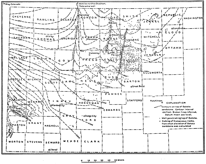
The rocks exposed in that part of western Kansas shown in Plate VII have at their base the Dakota sandstone, a formation about 300 feet thick consisting of sandstone, sandy shale, and clay shale. It crops out in a broad band extending northeastward from Edwards and Stafford counties to Washington County. Overlying the Dakota sandstone, and with outcrops paralleling it on the west, are the Graneros shale, which consists of dark gray to black clay shale 35 to 40 feet thick in the eastern part and 60 feet thick in the southwestern part of the area; the Greenhorn limestone, composed of alternately bedded thin limestone and limy shale, having a thickness of 100 feet in the eastern part arid 130 feet in the southwestern part; the Carlile shale, consisting of an upper division of. noncalcareous dark-gray shale with the Codell sandstone bed at the top, and a lower division of calcareous shale alternating with thin limestone, ranging in thickness between 300 feet in the eastern part and 250 feet in the southwest; and the Niobrara formation, which consists of about 700 feet of chalk beds and chalky shale, the basal 60 feet being distinguishable from the remainder by its superior hardness and small content of shale. (Logs of several wells drilled in Logan County a few miles south of Russell Springs show the Niobrara formation to be about 700 feet thick.) An unknown thickness of the gray Pierre shale occupies the extreme northwestern part of the state. According to a calculation based upon figures given by Mather, the Pierre shale is about 2,000 feet thick in the Wray gas field, Colorado, about 5 miles west of the Kansas boundary (Mather, K. F., U. S. Geol. Survey Press Notice, May 15, 1925). Overlapping the eroded edges of the formations above named from the Pierre shale to the Dakota sandstone is a series of sand, gravel, and clay beds of late Tertiary age (Ogalalla formation) that occupies the surface of the greater part of the western half of the area and extends far to the east on the high drainage divides. (Fig. 26.)
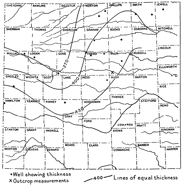
In the logs of wells drilled in this region the Pierre shale is not readily distinguishable from the Niobrara formation. The basal member of the Niobrara, which is, except for the Dakota sandstone, the best marker recorded in the logs of wells, is nearly always logged as "white limestone," above the several hundred feet of blue or black shale comprising the Carlile shale, the Greenhorn limestone, and the Graneros shale. The Codell sandstone, at the top of the Carlile, is recorded in the logs of nearly all wells that reach its horizon. The shale unit (the Carlile, Greenhorn, and Graneros formations) thickens southeastward from the northwestern part of the state. Figure 27 shows the approximate thickness of this unit in various parts of the region. However, at Wray, Colo., a few miles west of the northwest corner of Kansas, this unit is 400 feet thick, and it is known from numerous published reports that the Graneros shale thickens rapidly northwestward. The thinning in Kansas, therefore, cannot be projected northwestward. Moreover, the increase in thickness of the Graneros toward the northwest indicates that the Carlile shale and Greenhorn limestone probably bear all the thinning shown in northwestern Kansas.
Figure 27--Sketch map of western Kansas showing combined thickness of Carlile shale, Greenhorn limestone and Graneros shale.
The Dakota sandstone is the best marker in the stratigraphic section for regional study, its top being logged as sandstone, sandy shale and in some wells as red rock. Below the Dakota are 100 to 200 feet of dark shale and light-colored sandstone of Comanche age that may not extend throughout the area but are present at least in the southern part; a series of red beds; largely of Permian age, that ranges from less than 1,000 to more than 2,000 feet in thickness; and a series of Pennsylvanian limestones and. shales with a maximum thickness of more than 2,000 feet.
Structure
The most pronounced feature shown in Kansas on the structure map (Pl. VII), as well as on Darton's maps of 1905 and 1918, is the Cambridge anticline, more generally known as Darton's arch, the axis of which trends northward through the eastern edge of Decatur County into Nebraska. The structure contours in Decatur County and western Norton and Graham counties are based on a number of control points, but the southern extension of the nose of the anticline through southern Sheridan and Gove counties is largely conjectural. Because of its greater size as compared with the other folds in Kansas it offers an attractive field for prospecting and should be thoroughly tested. A well was drilled in 1925 near Norcatur, on the crest of the fold, and found several strong shows of oil.
A rather pronounced and extensive series of structural "highs" extends from northwestern Ellis County north-northeastward across Rooks County, passing a few miles west of Stockton and thence into Phillips County near Phillipsburg. It is possible that the nose crossing the southeast corner of Trego County is the southward continuation of the Stockton fold or one en echelon with it. A well south of Glade in Phillips County, another north of Stockton, and one southwest of Plainville in Rooks County: are being drilled on this regional "high." The Glade well has been reported shut down at a shallow depth for several months. Inasmuch as this well appears to be favorably located structurally, it is hope that the drilling will be continued. The Fairport-Natoma anticline, which is most prominent near the Russell oil field, extends north-northeastward from eastern Rush County into northern Osborne County.
In the southwestern part of the area the Syracuse anticline, in Hamilton County, is the most pronounced feature and is shown here much as presented on Darton's map, although some changes have been made. A well on the Syracuse anticline was drilled to a depth of 5,488 feet and encountered no encouraging shows of oil and only a small show of gas. The slight bending of the contours toward Scott City is based on a log of a water well given from memory, as a written record of the well could not be found. The position of the contours in this area is consequently subject to change.
It is hoped that the map here presented will not only be of some aid to the oil prospector in indicating the larger structural features of western Kansas, but may serve also the driller of water wells. For his benefit and guidance it may be said that the contours on the map show the approximate altitude above sea . level of the top of the Dakota sandstone. The altitude of the surface of much of the area east of the one-hundredth meridian and south of the thirty-eighth parallel can be determined from topographic maps of the Geological Survey, which may be purchased at 10 cents a copy from the Director, U. S. Geological Survey, Washington, D. C., or the State Geologist, Lawrence, Kan.
In the northwestern part of the state, comprising some 13 counties and parts of others, no topographic surveys have been made. Altitude can be determined from railroad stations, the difference between the altitude of the particular section of land involved. and that of the station being estimated. From these determinations and the altitude of the top of the Dakota, as shown on the map, a fair approximation of the depth necessary to drill to obtain water from the Dakota can be readily calculated.
Prev Page--Hamilton County || Next Page--Salt Beds
Kansas Geological Survey, Geology
Placed on web July 2, 2015; originally published April 1926.
Comments to webadmin@kgs.ku.edu
The URL for this page is http://www.kgs.ku.edu/Publications/Bulletins/11/04_dakota.html