Kansas Geological Survey, Bulletin 109, pt. 9, originally published in 1954
Originally published in 1954 as Kansas Geological Survey Bulletin 109, pt. 9. This is, in general, the original text as published. The information has not been updated. An Acrobat PDF version (19.6 MB) is also available.
The Norton oil field, in Norton County, Kansas, about 6 miles southwest of the town of Norton, was discovered in May 1953. Late in August 1954, there were 97 producing wells, and the field included about 1,700 acres. Production is from the Arbuckle dolomite, Cambro-Ordovician in age, and from the Reagan sandstone, Cambrian in age.
The report contains four structure maps of the field: (1) top of the Stone Corral formation, (2) top of the Lansing group, (3) base of the Kansas City group, and (4) top of the Arbuckle group. A pre-Pennsylvanian areal geologic map, an east-west cross section of Norton County, a contour map on top of the Pre-Cambrian rocks, and a dry hole map of the county are included.
The oil field is situated on the southeastern end of the Cambridge arch. A series of uplifts and tiltings accompanied at various times by orogenic folding comprise the tectonic history of the region. The structure on which the field is located is an elongated northeast-southwest trending anticline of low relief. The northwest flank of the structure was partially truncated by post-Arbuckle erosion. A study of the relation of structure to depth indicates that the axis of the anticline shifts southeastward with depth and that the fold increases in intensity with depth.
Oil accumulation is controlled by a combination of truncation and overlap and change in porosity of the reservoir beds and structure. The similarity of this field to fields of the Central Kansas uplift is discussed.
In recent years the need for additional oil reserves has resulted in an increase in exploratory activity in far western Kansas. Wildcat drilling in the region resulted in sufficient data to indicate the possibility of stratigraphic entrapment of oil in the vicinity of the Cambridge arch, similar to that of the Central Kansas uplift. The discovery of the Norton oil field, the first major producing area, rates as one of the most important discoveries in western Kansas during the last few years. This study was undertaken to determine the geological conditions under which the oil occurs and, in that way, perhaps to indicate other geologically similar areas that might prove profitable for future explorations.
The Norton field, approximately 3 miles long and 1 mile wide, is located about 6 miles southwest of Norton, Kansas. The field contained 97 producing wells late in August 1954, and had a proved area of about 1,700 acres. The field was discovered by the Jones, Shelburne, and Farmer, Inc. No. 1 Lawson well in the SE SE NW sec. 36, T. 3 S., R. 24 W. This well, completed in May 1953, had an initial potential of 200 barrels of oil per day from Arbuckle rocks from 3,778 to 3,790 feet depth. The development of the field after the initial discovery was rapid.
The information for the maps and cross sections was obtained from electric logs, gamma ray logs, logs of the Kansas Sample Log Service, drillers logs, scout tops, and sample logs which were available to the Survey. Much of the information taken from drillers logs and scout tops has been substantiated. These data are considered to be of a quality sufficient to warrant the detail shown.
An early reconnaissance of the surface geology of Norton County was published by Hay (1885). Frye and Leonard (1949) describe the surface geology, present a detailed geologic map of the county, and show the oil wells that were drilled up to the time of publication in 1949. Byrne, Beck, and Bearman (1949) also did detailed surface geologic work in connection with the location of construction material in the county. Reports by Lee and Merriam (1954), Merriam and Frye (1954), and Merriam and Atkinson (in press) concern the structural development of western Kansas, including Norton County, and especially the tectonic history of the Cambridge arch. Location of the oil fields and pipe lines in Kansas as of January 1, 1953, are shown on a map prepared by Goebel (1953). Detailed accounts of oil and gas exploration in the county have been published yearly since 1941 (Ver Wiebe, 1942, 1943, 1944, 1945, 1946, 1947; Ver Wiebe and others, 1948, 1949, 1950, 1951, 1952, 1953, 1954).
Thanks are extended to Mr. V. Jean Taylor, consulting geologist for Mr. Harry Gore, and Mr. Jacob E. Lemmons and Mr. Francis C. Whisler of Jones, Shelburne, and Farmer, Inc. who checked the structure maps and provided correct sample tops. Mr. William R. Atkinson, student at the University of Kansas, helped check and plot information used in preparing the structure maps and cross sections.
On May 12, 1953, the discovery well of the Norton field was completed by Jones, Shelburne, and Farmer, Inc. on the Lawson lease in the SE SE NW sec. 36, T. 3 S., R. 24 W.
The new field was originally called the Columbia field by the Kansas Nomenclature Committee. At the June 1953 meeting of the Committee, when a petition from the Norton Chamber of Commerce was considered, the name of the important discovery was changed to Norton.
The upper part of the Lansing group of rocks from depths of 3,532 to 3,562 feet was drill-stem tested unsuccessfully. The second drill-stem test, in Arbuckle rocks from the top at 3,778 feet to the total depth of 3,790 feet with tool opened for 1 hour, recovered 540 feet of gas and 1,110 feet of free, gassy, 38° gravity oiL The bottom-hole pressure was reported as 1,360 pounds. After the hole was cleaned out, 2,850 feet of oil accumulated in 12 hours. The well then produced 118 barrels of 31.90 gravity oil per day for 3 days on pumping tests before it was assigned a physical potential of 200 barrels of oil per day from Arbuckle rocks.
The Norton East field, opened in August 1953, was also discovered by Jones, Shelburne, and Farmer, Inc. The discovery well, the No. 1 Mindrup in the SW SW NW sec. 31, T. 3 S., R. 23 W., was gauged at 261 barrels of oil per day from Arbuckle rocks between depths of 3,745 and 3,755 feet. Also in August 1953, an offset to the south drilled by Harry Gore on the Scott lease in the NW NW NE sec. 1, T. 4 S., R. 24 W., discovered the Norton South field. An initial potential of 323 barrels of oil per day was assigned from the Arbuckle rocks between 3,805 to 3,813 feet. At the September 1953 meeting of the Nomenclature Committee, the three fields were combined and designated the Norton field because of the proximity of the similar producing zones.
By the end of 1953, 35 producing wells had been completed; 55 additional wells were completed in the first 7 months of 1954 so that by the end of August 1954, the field had 97 producing wells. Four of these—the Dane Hansen No. 2 Weber, NW NW SW sec. 30, T. 3 S., R. 23 W.; the Harry Gore' No. 4 Calvin Lawson, NE NE SE sec. 30; the Jones, Shelburne, and Farmer, Inc. No. 1 Schoen "C," SE SW SW sec. 30; and the Wood River Oil and Refining Company, Inc. No. 4 Fought, NE NW SE sec. 25, T. 3 S., R. 24 W.—produce from the Reagan sandstone, and one, the Harry Gore No. 1 Horning in the SW SW NE sec. 30, T. 3 S., R. 23 W., produces from a detrital zone which probably is a correlative of the Reagan sandstone. The reported initial potential of all 97 wells ranged from 77 barrels of oil per day in the Harry Gore No. 1 Henry in the NE NE NW sec. 2, T. 4 S., R. 24 W. to 364 barrels per day in the Derby Oil Company No. 3 Schoen in the Cen. N2 N2 SE sec. 35, T. 3 S., R. 24 W. One well, the Jones, Shelburne, and Farmer, Inc. No. 3 Schoen "A" in the NE NE NE sec. 35, T. 3 S., R. 24 W., is reported to be temporarily abandoned.
Up to August 20, 1954, 142 dry holes were reported drilled in Norton County. The well locations are shown in Figure 1 and pertinent information for each well is given in Table 1. Almost all these dry holes were drilled since 1940, and the majority of them since the Norton field discovery in 1953. There are four townships in which no wells have been drilled, three have only 1 well, three have 2 wells, and three have 3 wells, so that the dry hole density is about 1 per 6.3 square miles. However, this is slightly misleading since in a large part of the county, Pre-Cambrian rocks are directly overlain by Pennsylvanian rocks and the potential oil-bearing Arbuckle and Reagan rocks are missing.
Figure 1—Dry hole map of Norton County, Kansas. This map shows 142 dry holes drilled in the county as of August 20, 1954.
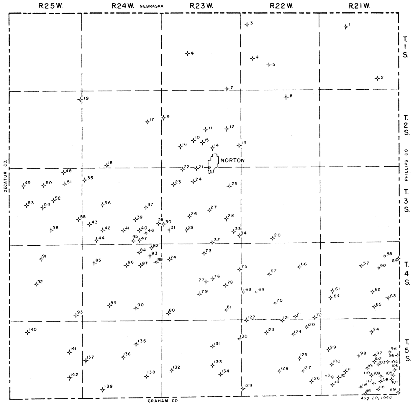
Table 1—List of dry holes drilled in Norton County to August 20, 1954.
| No. on map |
Company and farm | Location | Date completed |
Total depth, feet |
Lowest horizon penetrated |
|---|---|---|---|---|---|
| 1. | The Derby Oil Co. No. 1 Foland |
NENENE 8-1-21W |
11-7-1946 | 3,775 | Arbuckle |
| 2. | Barnsdall Oil Co. No. 1 C. P. Ramsey |
CNENW 35-1-21W |
4-25-1941 | 3,810 | Arbuckle |
| 3. | Empire Drlg. Co. No. 1 Atens Est. |
SESESW 6-1-22W |
11-16-1952 | 3,695 | Pre-Cambrian |
| 4. | Jones, Shelburne & Farmer, Inc. No. 1 Keene |
NENESE 18-1-22W |
8-18-1954(?) | 3,710 | Pre-Cambrian |
| 5. | Jones, Shelburne & Farmer, Inc. No. 1 McCelland |
NWNWNW 28-1-22W |
6-11-1954 | 3,770 | Pre-Cambrian |
| 6. | Phillips Petro Co. No. 1 Wyatt |
CE2NENE 20-1-23W |
8-4-1941 | 3,618 | Pre-Cambrian |
| 7. | Great Lakes Carbon Corp. No. 1 Minshall |
SESESE 35-1-23W |
7-15-1951 | 3,785 | Pre-Cambrian |
| 8. | Sohio Petro. Co. et al. No. 1 Reeves |
NENESW 3-2-22W |
10-30-1946 | 3,755 | Pre-Cambrian |
| 9. | Jones, Shelburne & Farmer, Inc. No. 1 Sanderson "B" |
NWNWNW 18-2-23W |
5-7-1954 | 3,750 | Pre-Cambrian |
| 10. | Empire Drlg. Co. No. 1 Kohfeld |
SESESW 21-2-23W |
3-24-1954 | 3,653 | Pre-Cambrian |
| 11. | R. W. Rine Drlg. Co. No. 1 Wallack |
CNENW 22-2-23W |
4-24-1942 | 3,733 | Pre-Cambrian |
| 12. | B & R Drlg. Co. No. 1 Scott |
NE2NE 23-2-23W |
1-22-1945 | 3,666 | Pre-Cambrian |
| 13. | Helmerich & Payne, Inc. No. 1 Central Trust Co. |
CE2SENE 25-2-23W |
12-6-1941 | 3,661 | Arbuckle (?) |
| 14. | Jones, Shelburne & Farmer, Inc. No. 1 City of Norton |
NENESE 27-2-23W |
12-20-1953 | 3,730 | Pre-Cambrian |
| 15. | Empire Drlg. Co. et al. No. 1 Wallack |
NWNWNW 27-2-23W |
4-25-1953 | 3,660 | Pre-Cambrian |
| 16. | Allan & Aylward No. 1 Lecky |
SENW 29-2-23W |
8-14-1944 | 3,691 | Pre-Cambrian |
| 17. | Jones, Shelburne & Farmer, Inc. No. 1 Sheldon |
SESENE 14-2-24W |
8-13-1954 | 3,702 | Pre-Cambrian |
| 18. | Barnett Oil Co. No. 1 Legg |
SESESE 32-2-24W |
12-11-1953 | 3,672 | Pre-Cambrian |
| 19. | Helmerick & Payne, Inc. No. 1 Lacount |
CNESE 1-2-25W |
12-12-1941 | 3,727 | Pre-Cambrian |
| 20. | Allan & Aylward No. 1 Fed. Farm Mort. Corp. |
NESW 33-3-22W |
9-22-1944 | 3,864 | Pre-Cambrian |
| 21. | Keating Drlg. Co. No. 1 Wesley |
NWNWNE 4-3-23W |
6-2-1952 | 3,628 | Pre-Cambrian |
| 22. | Jones, Shelburne & Farmer, Inc. No. 1 Coleman |
NWNWNE 5-3-23W |
1-2-1954 | 3,655 | Pre-Cambrian |
| 23. | Phillips Petro. Co. No. 1 Conway |
CSENE 7-3-23W |
12-31-1941 | 3,640 | Pre-Cambrian |
| 24. | Harry Gore No. 1 Snyder |
NENENW 9-3-23W |
10-24-1953 | 3,575 | Pre-Cambrian |
| 25. | Great Lakes Carbon Corp. No. 1 Muir |
NWNWSW 12-3-23W |
7-11-1951 | 3,722 | Pre-Cambrian |
| 26. | United Drlg., Inc. No. 1 Horesky |
SWSWSW 21-3-23W |
6-21-1954 | 3,764 | Pre-Cambrian |
| 27. | Lario Oil & Gas Co. No. 1 Kennedy |
CSWSWNE 22-3-23W |
3-29-1936 | 3,692 | Pre-Cambrian |
| 28. | Jones, Shelburne & Farmer, Inc. No. 1 Stewart |
NENENE 26-3-23W |
5-28-1954 | 3,778 | Pre-Cambrian |
| 29. | Jones, Shelburne & Farmer, Inc. No. 1 Horesky |
SESESE 29-3-23W |
12-8-1953 | 3,779 | Pre-Cambrian |
| 30. | Harry Gore No. 8 Calvin Lawson |
SWSWNW 30-3-23W |
5-10-1954 | 3,710 | Pre-Cambrian |
| 31. | D. G. Hansen No. 5 Weber |
SWSWSE 30-3-23W |
4-26-1954 | 3,810 | Pre-Cambrian |
| 32. | Harry Gore No. 1 Hershiser |
SESESE 34-3-23W |
9-14-1953 | 3,814 | Pre-Cambrian |
| 33. | Phillips Petro. Co. No. 1 Myra |
NENW 36-3-23W |
7-19-1944 | 3,732 | Pre-Cambrian |
| 34. | Helmerich & Payne, Inc. No. 1 Smith |
SE2NE 36-3-23W |
3-3-1943 | 3,772 | Pre-Cambrian |
| 35. | Sauvage & Dunn No. 1 Collins |
SESWSW 6-3-24W |
8-24-1953 | 3,786 | Pre-Cambrian |
| 36. | Trans-Era Petro., Inc. No. 1 King |
SWSWSE 17-3-24W |
2-11-1954 | 3,675 | Pre-Cambrian |
| 37. | Jones, Shelburne & Farmer, Inc. No. 1 Gooder |
NENENE 23-3-24W |
10-30-1953 | 3,720 | Pre-Cambrian |
| 38. | Harry Gore No. 5 Calvin Lawson |
SWSENE 25-3-24W |
2-22-1954 | 3,740 | Pre-Cambrian |
| 39. | Allan & Aylward No. 1 Porter |
NW2NW 26-3-24W |
7-20-1944 | 3,743 | Pre-Cambrian |
| 40. | Empire Drlg. Co. No. 1 M. Davis |
SESESW 26-3-24W |
6-19-1953 | 3,820 | Pre-Cambrian |
| 41. | Jones, Shelburne & Farmer, Inc. No. 1 Brown |
SWSWSW 27-3-24W |
2-1-1954 | 3,799 | Pre-Cambrian |
| 42. | Jones, Shelburne & Farmer, Inc. No. 1 Ankenman |
SWSWSE 29-3-24W |
4-16-1954 | 3,811 | Pre-Cambrian |
| 43. | Harry Gore and Trans-Era Petro., Inc. No. 1 Clark |
SWSWNE 30-3-24W |
10-26-1953 | 3,830 | Pre-Cambrian |
| 44. | Harry Gore No. 1 Brunson |
NWNWSW 32-3-24W |
7-23-1954 | 3,912 | Pre-Cambrian |
| 45. | Jones, Shelburne & Farmer, Inc. No. 1 Conover |
SENESE 34-3-24W |
8-20-1953 | 3,783 | Pre-Cambrian |
| 46. | Jones. Shelburne & Farmer, Inc. No. 3 Schoen "A" |
NENENE 35-3-24W |
2-9-1954 | 3,792 | Reagan |
| 47. | Harry Gore No. 1 Henry |
SENESW 35-3-24W |
4-22-1954 | 3,750 | Pre-Cambrian |
| 48. | R. W. Shields No. 1 Hicks |
CSWNE 2-3-25W |
9-7-1943 | 3,833 | Pre-Cambrian |
| 49. | Henderson Oil Co. et al. No. 1 Leichliter |
SWSWNE 8-3-25W |
3-9-1954 | 3,958 | Pre-Cambrian |
| 50. | R. W. Shields No. 1 Mizell |
SWSWNW 10-3-25W |
1-8-1954 | 3,902 | Pre-Cambrian |
| 51. | Helmerich & Payne. Inc. et al. No. 1 Collins |
CNE 11-3-25W |
2-17-1936 | 3,800 | Pre-Cambrian |
| 52. | Cities Service Oil Co. No. 1 Mizell |
NESE 15-3-25W |
4-2-1942 | 3,897 | Pre-Cambrian |
| 53. | Anderson-Prichard Oil Corp. No. 1 Brooks |
SESESE 17-3-25W |
7-4-1953 | 3,895 | Pre-Cambrian |
| 54. | Jones. Shelburne & Farmer, Inc. No. 1 Brunk |
NWNWNW 22-3-25W |
6-11-1954 | 3,822 | Pre-Cambrian |
| 55. | Trans-Era Petro., Inc. No. 1 Humphrey |
N2NENE 25-3-25W |
2-23-1954 | 3,730 | Pre-Cambrian |
| 56. | Empire Drlg. Co. No. 1 Gray |
SWSESE 27-3-25W |
8-20-1952 | 3,875 | Pre-Cambrian |
| 57. | Murfin Drlg. Co. No. 1 Lowery |
SWSWSW 10-4-21W |
9-28-1951 | 3,788 | Arbuckle |
| 58. | Phillips Petro. Co. No. 3 Hewett |
CNENE 11-4-21W |
2-12-1942 | 3,438 | Pennsylvanian (?) |
| 59. | Power Oil Co. No. 1 Frank Neel |
CE2NE 12-4-21W |
9-17-1938 | 3,801 | Arbuckle |
| 60. | Empire Drlg,. Co. No. 1 Cooley |
NENENW 14-4-21W |
12-10-1951 | 3,727 | Arbuckle |
| 61. | B&R Drlg., Inc. No. 1 Stone |
SESESE 19-4-21W |
7-5-1951 | 3,700 | Arbuckle |
| 62. | Nadel & Gussman No. 1 C. E. Smith |
SESE 22-4-21W |
5-29-1943 | 3,680 | Arbuckle |
| 63. | H. A. Steele No. 1 Becker |
CSWNW 25-4-21W |
11-20-1940 | 1,234 | "Dakota" |
| 64. | Natl. Coop. Ref. Assn. No. 1 Stone |
NWSENE 30-4-21W |
4-2-1954 | 3,688 | Arbuckle |
| 65. | Hinkle Oil Co. No. 1 Wiltrout |
NWNWNW 35-4-21W |
10-19-1951 | 3,627 | Arbuckle |
| 66. | Jones, Shelburne & Farmer, Inc. No. 1 Fisher |
SWSESW 11-4-22W |
5-28-1954 | 3,767 | Arbuckle |
| 67. | Jones, Shelburne & Farmer, Inc. No. 1 Wilds |
SWSWNW 16-4-22W |
6-4-1954 | 3,892 | Pre-Cambrian |
| 68. | Jones, Shelburne & Farmer, Inc. No. 1 Wiley |
SWSWSW 19-4-22W |
11-3-1953 | 3,720 | Pre-Cambrian |
| 69. | Trans-Era Petro., Inc. No. 1 Trobee |
SWSWSW 20-4-22W |
8-31-1953 | 3,764 | Pre-Cambrian |
| 70. | Rex & Morris Drlg. Co. No. 1 Weathers |
NWSWSE 28-4-22W |
9-19-1950 | 3,807 | Pre-Cambrian |
| 71. | Jones, Shelburne & Farmer, Inc. No. 1 Peak |
SWSWSW 35-4-22W |
4-11-1953 | 3,675 | Reagan |
| 72. | Harry Gore No. 1 Walters |
SWSWSE 36-4-22W |
7-11-1953 | 3,710 | Pre-Cambrian |
| 73. | Allan & Aylward No. 1 Comstock |
SWSW 3-4-23W |
9-4-1944 | 3,900 | Pre-Cambrian |
| 74. | Alpine Oil & Royalty Co., Inc. No. 1 Horesky |
NWSWNE 7-4-23W |
2-20-1954 | 3,867 | Pre-Cambrian |
| 75. | Cities Service Oil Co. No. 1 Boucher |
NENE 13-4-23W |
8-22-1941 | 3,813 | Pre-Cambrian |
| 76. | Cities Service Oil Co. No. 1 Fed. Farm Mort. Corp. |
SESE 15-4-23W |
7-28-1941 | 3,794 | Pre-Cambrian |
| 77. | Harry Gore No. 1 Bullock |
NENENW 22-4-23W |
1-22-1952 | 3,857 | Pre-Cambrian |
| 78. | The Texas Co. No. 1 M. S. Harmonson |
SESENE 23-4-23W |
11-8-1951 | 3,748 | Pre-Cambrian |
| 79. | Trans-Era Petro., Inc. No. 1 Schaudler |
NENENE 28-4-23W |
5-6-1954 | 3,874 | Pre-Cambrian |
| 80. | Empire Drlg. Co. et al. No. 1 Muir |
NWNWSE 31-4-23W |
11-28-1951 | 3,845 | Arbuckle |
| 81. | Cities Service Oil Co. No. 1 "E" Johnson |
NESENE 35-4-23W |
8-5-1946 | 3,765 | Pre-Cambrian |
| 82. | Jones. Shelburne & Farmer, Inc. No. 5 Green |
C NW 1-4-24W |
8-18-1954(?) | 3,830 | Arbuckle |
| 83. | Jones, Shelburne & Farmer, Inc. No. 1 Sanderson |
SWSWSW 1-4-24W |
12-5-1953 | 3,905 | Pre-Cambrian |
| 84. | Jones. Shelburne & Farmer, Inc. No. 1 Radloff |
NENESW 2-4-24W |
7-28-1953 | 3,802 | Reagan |
| 85. | The Texas Co. No. 1 J. W. Gleason |
SESENE 7-4-24W |
7-29-1952 | 3,950 | Arbuckle |
| 86. | Helmerich & Payne, Inc. No. 1 Paxton |
CNESW 10-4-24W |
11-15-1942 | 3,963 | Pre-Cambrian |
| 87. | The Texas Co. No. 1 M. B. Reed |
SENESW 11-4-24W |
3-13-1954 | 3,865 | Pre-Cambrian |
| 88. | Sinclair Prairie Oil Co. No. 1 Mildred Reed |
SWNE 12-4-24W |
1-14-1945 | 3,869 | Pre-Cambrian |
| 89. | Stanolind Oil & Gas Co. No. 1 W. N. Steelsmith |
SWSW 28-4-24W |
5-22-1942 | 3,932 | Pre-Cambrian |
| 90. | Wilcox Oil Co. No. 1 Wagoner |
NWNWNW 35-4-24W |
11-24-1947 | 3,885 | Arbuckle |
| 91. | Harry Gore No. 1 Brooks |
NENENE 9-4-25W |
10-7-1951 | 3,903 | Arbuckle |
| 92. | Harry Gore No. 1 Wolf |
NWNWNE 21-4-25W |
10-26-1951 | 4,055 | Arbuckle |
| 93. | Anschutz Drlg. Co. No. 1 Zeirlin |
NWNWSE 36-4-25W |
7-8-1952 | 3,918 | Arbuckle |
| 94. | Bridgeport Oil Co., Inc. No. 1 Riemann "A" |
NENE 10-5-21W |
6-1-1945 | 3,620 | Pre-Cambrian |
| 95. | Flournoy & Williams et al. No. 1 Thomas |
SESESE 13-5-21W |
2-16-1951 | 3,562 | Arbuckle |
| 96. | Berry & Fick No. 1 Baird |
NENWSW 13-5-21W |
2-4-1954 | 3,568 | Arbuckle |
| 97. | The Texas Co. No. 1 Dora Criswell |
SWSWSW 14-5-21W |
8-19-1950 | 3,620 | Reagan |
| 98. | Helmerich & Payne, Inc. No. 1 Kitzke |
SESESE 16-5-21W |
3-6-1946 | 3,711 | Pre-Cambrian |
| 99. | Cities Service Oil Co. No. 1 Harrison |
SWNE 18-5-21W |
7-29-1942 | 3,599 | Pre-Cambrian |
| 100. | Phillips Petro. Co. No. 1 Voss |
NESE 19-5-21W |
1-22-1942 | 3,733 | Pre- Cambrian |
| 101. | Tidewater Assoc. Oil Co. No. 1 Noel |
SWSWSE 22-5-21W |
7-8-1946 | 3,659 | Reagan |
| 102. | Empire Drlg. & Cranlyn No. 1 Schugart |
SWSENW 23-5-21W |
11-6-1953 | 3,613 | Arbuckle |
| 103. | Cranlyn Exploration No. 1 Schugart "B" |
NENWSW 23-5-21W |
6-25-1954 | 3,647 | Arbuckle |
| 104. | Helmerich & Payne, Inc. No. 1 "A" Baird |
CS2SWNW 24-5-21W |
9-15-1946 | 3,695 | Reagan |
| 105. | Barnett Oil Co. No. 1 Kemper |
SWSWNE 25-5-21W |
4-23-1952 | 3,720 | Pre-Cambrian |
| 106. | Geo. F. Johnston No. 1 Kemper |
NENWNE 25-5-21W |
8-10-1947 | 3,740 | Reagan |
| 107. | Cities Service Oil Co. No. 4 Kitzke |
NESESW 25-5-21W |
3-31-1948 | 3,714 | Pre-Cambrian (?) |
| 108. | Phillips Petro. Co. No. 1 Dedrick |
SWSWSE 26-5-21W |
1-23-1946 | 3,738 | Pre-Cambrian |
| 109. | Cranlyn Exploration No. 1 Dedrick |
NWNWSE 26-5-21W |
6-25-1954 | 3,697 | Arbuckle |
| 110. | Cities Service Oil Co. No. 1 Wiltrout |
SENE 27-5-21W |
4-11-1945 | 3,678 | Arbuckle |
| 111. | Jones, Shelburne & Farmer, Inc. No. 1 Damewood |
NENENE 29-5-21W |
9-8-1953 | 3,682 | Reagan |
| 112. | Brooks-Hall No. 1 Louis Voss |
NENESW 29-5-21W |
5-2-1952 | 3,771 | Reagan |
| 113. | Phillips Petro. Co. No. 1 Irma |
NESE 30-5-21W |
8-5-1943 | 3,786 | Reagan |
| 114. | Phillips Petro. Co. No. 1 Tuck |
SENENE 31-5-21W |
5-17-1944 | 3,795 | Pre-Cambrian |
| 115. | Cities Service Oil Co. No. 1 Muir |
SWNW 34-5-21W |
12-22-1941 | 3,788 | Pre-Cambrian |
| 116. | Saturn Drlg. Co. et al. No. 1 Sullivan |
SESESW 34-5-21W |
5-23-1952 | 3,697 | Pre-Cambrian |
| 117. | Don Pratt No. 1 Griffin |
NWNWNW 35-5-21W |
11-21-1952 | 3,728 | Pre-Cambrian |
| 118. | D. G. Hansen No. 1 Sullivan |
NENESW 35-5-21W |
12-3-1946 | 3,660 | Pre-Cambrian |
| 119. | Cities Service Oil Co. No. 2 Kitzke |
NESESE 36-5-21W |
8-9-1942 | 3,611 | Pre-Cambrian |
| 120. | D. G. Hansen No. 1 Allen |
SENESE 2-5-22W |
12-17-1950 | 3,526 | Reagan |
| 121. | Trans-Era Petro., Inc. No. 1 Schafer |
NWNWNW 3-5-22W |
8-17-1953 | 3,644 | Arbuckle |
| 122. | Cities Service Oil Co. No. 1 B.M.A. |
NENW 6-5-22W |
10-26-1942 | 3,775 | Pre-Cambrian |
| 123. | Cities Service Oil Co. No. 1 Fredde |
NENENE 8-5-22W |
12-22-1951 | 3,620 | Pre-Cambrian |
| 124. | Harry Gore No. 1 Voss |
SENENE 10-5-22W |
6-3-1952 | 3,605 | Pre-Cambrian |
| 125. | Trans-Era Petro., Inc. No. 1 McKinley |
NENENW 23-5-22W |
7-1-1954 | 3,790 | Arbuckle |
| 126. | Cities Service Oil Co. No. 1 Armstrong |
SWSESW 25-5-22W |
5-28-1947 | 3,881 | Pre-Cambrian |
| 127. | Hall-Jordan Oil Co. No. 1 Von Mayrhauser |
CN2NWNE 26-5-22W |
6-25-1941 | 3,722 | Pre-Cambrian |
| 128. | Peel-Hardman No. 1 Long |
NENENE 28-5-22W |
2-28-1954 | 3,770 | Arbuckle |
| 129. | Empire Drlg. Co. No. 1 Schuck |
SWSWNW 31-5-22W |
2-20-1952 | 3,999 | Arbuckle |
| 130. | Empire Drlg. Co. No. 1 Magil |
NENESE 12-5-23W |
3-14-1954 | 3,780 | Arbuckle |
| 131. | Harry Gore No. 1 Leidig |
NENENE 15-5-23W |
8-16-1951 | 3,752 | Arbuckle |
| 132. | Potash Co. of America No. 1 Bennett |
SWSESE 19-5-23W |
6-24-1926 | 3,846 | Arbuckle |
| 133. | The Derby Oil Co. No. 1 Delp |
CNESE 22-5-23W |
6-26-1942 | 3,897 | Arbuckle |
| 134. | Cities Service Oil Co. No. 1 Sullivan |
SESENW 26-5-23W |
11-8-1953 | 3,880 | Arbuckle |
| 135. | Peel-Hardman Oil Prod. No. 1 Allen |
SWSWSW 11-5-24W |
5-21-1951 | 3,835 | Arbuckle |
| 136. | Vickers Petro. Co., Inc. No. 1 Bozarth |
CSWSW 15-5-24W |
8-31-1938 | 3,885 | Arbuckle |
| 137. | Musgrove Petro. Corp. No. 1 Hickert |
NENWNW 19-5-24W |
2-22-1952 | 3,930 | Arbuckle |
| 138. | Jones, Shelburne & Farmer, Inc. No. 1 Dwyer |
SESENE 26-5-24W |
1-8-1952 | 3,970 | Arbuckle |
| 139. | Jones, Shelburne & Farmer, Inc. No. 1 Hickert |
SWSWNE 32-5-24W |
12-23-1951 | 4,085 | Arbuckle |
| 140. | Harry Gore No. 1 Scheetz |
SESESE 5-5-25W |
9-24-1951 | 4,125 | Arbuckle |
| 141. | Herndon Drlg. Co. No. 1 Mindrup |
SWSWNW 13-5-25W |
9-8-1951 | 4,003 | Arbuckle |
| 142. | Musgrove Petro. Corp. No. 1 Hickert |
SWSWNW 25-5-25W |
3-3-1952 | 4,000 | Arbuckle |
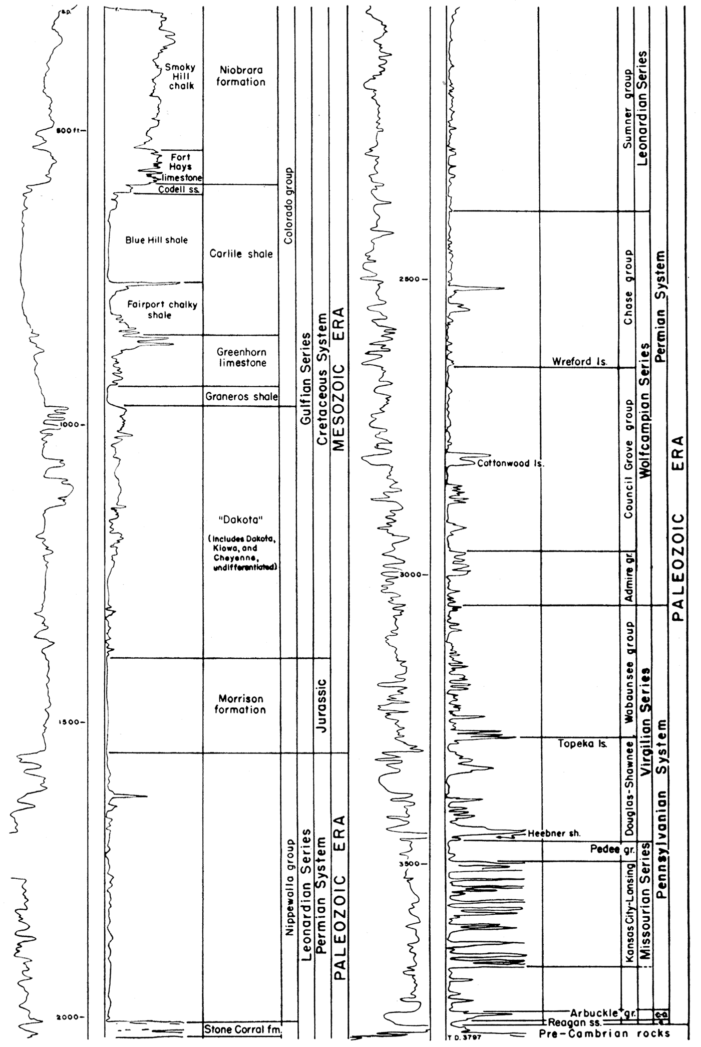
The stratigraphic sequence present in the Norton oil field is represented graphically in Figure 2. The electric log for the Derby Oil Company No. 4 Schoen well is used to show relative positions of the formations up to and including the Niobrara formation. The rocks penetrated range in age from Pre-Cambrian to surficial Quaternary deposits. Well samples from six wells in or near the field were available for study. They are the Allen and Aylward No. 1 Porter, sec. 26, T. 3 S., R. 24 W.; Empire Drilling Company No. 1 Davis, sec. 26, T. 3 S., R. 24 W. (a log of the Kansas Sample Log Service); Harry Gore No. 1 Lawson, sec. 25, T. 3 S., R. 24 W.; Harry Gore No. 1 Scott, sec. 1, T. 4 S., R. 24 W.; Jones, Shelburne, and Farmer, Inc. No. 1 Lawson, sec. 36, T. 3 S., R. 24 W. (a log of the Kansas Sample Log Service); and Jones, Shelburne, and Farmer, Inc. No. 1 Mindrup, sec. 31, T. 3 S., R. 23 W. Samples above the Pennsylvanian were available from only one of these, the Allen and Aylward No. 1 Porter well. However, 1,260 feet of samples, from the lower part of the Cretaceous to the upper part of the Permian, were missing. Descriptions of Quaternary, Tertiary, and the upper part of the Cretaceous rocks have been adapted from Frye and Leonard (1949). Regional and more complete lithologic descriptions are given by Moore and others (1951).
Figure 2—Stratigraphic sequence in the Norton oil field, Norton County, Kansas. This is an electric log of The Derby Oil Company No. 4 Schoen well in the Cen. SE sec. 35, T. 3 S., R. 24 W., which shows the relation of the different strata. (C-O, Cambro-Ordovician System; C, Cambrian System.)
The top of Pre-Cambrian rocks is reported only as granite or granite-wash in the majority of the wells in Norton County. Pre-Cambrian rocks were penetrated by only five of the wells in the Norton field according to scout information. The sample log of the Empire Drilling Company No. 1 Davis well, in sec. 26, T. 3 S., R. 24 W., shows chlorite mica schist with traces of weathered-appearing pink feldspar. Biotite-bearing pink granite was logged from the Allen and Aylward No. 1 Porter well, also in sec. 26.
The configuration of the Pre-Cambrian surface in Norton County is represented in Figure 3. The contours show a saddle separating the Cambridge arch on the northwest from the Central Kansas uplift on the southeast. The lowest part of the saddle between the uparched areas is in the northern part of T. 5 S., R. 22 W. The Cambridge arch is a southerly plunging northwest-southeast trending major anticlinal structure, only the southern end of which is in Kansas; the greater part of the structure is in south-central Nebraska. The Central Kansas uplift in the area is a low, northerly plunging, northwest-southeast trending anticlinal structure.
Figure 3—Map showing the configuration on the top of Pre-Cambrian rocks in Norton County, Kansas. The illustration reveals a low saddle which separates the Cambridge arch, on the northwest. from the Central Kansas uplift, on the southeast.
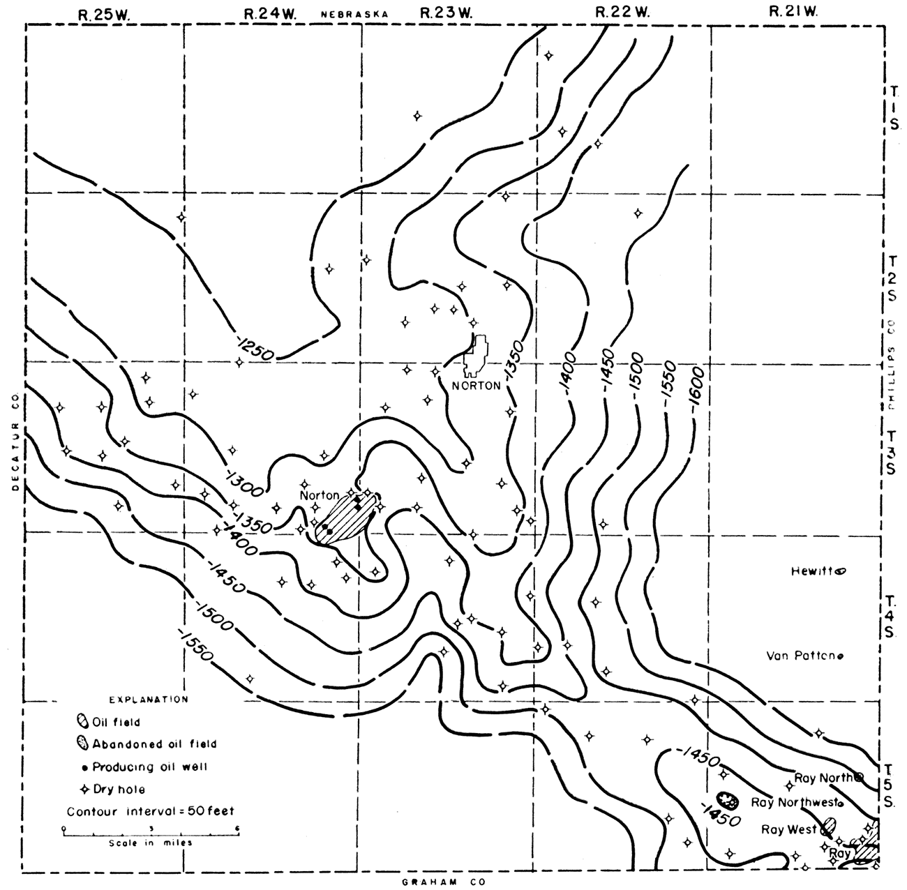
The minor irregularities of the Pre-Cambrian surface are probably due to post-Pre-Cambrian erosion. The surface, or parts of it, was probably exposed to erosion at several periods before it was finally covered by Pennsylvanian sediments. Valleys on the Pre-Cambrian surface opening southward on each side of the Norton field are suggested by the contours in T. 4 S., Rs. 23 and 24 W. The field lies on a ridge or spur between the two valleys. Another such valley, which opens to the east, is suggested in T. 2 S., R. 23 W.
Commonly, the Arbuckle rocks are the oldest rocks tested for the occurrence of oil and gas in the area. As a result, few data on the top of the Pre-Cambrian are available and there is little control on the Pre-Cambrian surface on either flank of the arch.
The Reagan (Lamotte) sandstone is composed of rounded to angular, fine to coarse, poorly sorted grains. Locally, arkosic material occurs in the lower part of the formation (Moore and others, 1951, p. 122). A description of the formation in the Norton field or vicinity cannot be given because sample cuttings are not available. The sandstone is 9 feet thick in The Derby Oil Company No. 4 Schoen well, Cen. SE sec. 35, T. 3 S., R. 24 W. (Fig. 2). Where present, the formation unconformably overlies the Pre-Cambrian surface.
No attempt was made in this study to subdivide the Arbuckle group; thus it is considered Cambro-Ordovician in age. It is probable, however, that only that part of the group which is Cambrian in age is present. The Arbuckle is composed of gray or buff to brown, medium to coarsely crystalline, sandy, glauconitic, porous dolomite. In the Norton field, the thickness ranges from a featheredge to 26 feet, but increases sharply away from the flanks of the Cambridge arch.
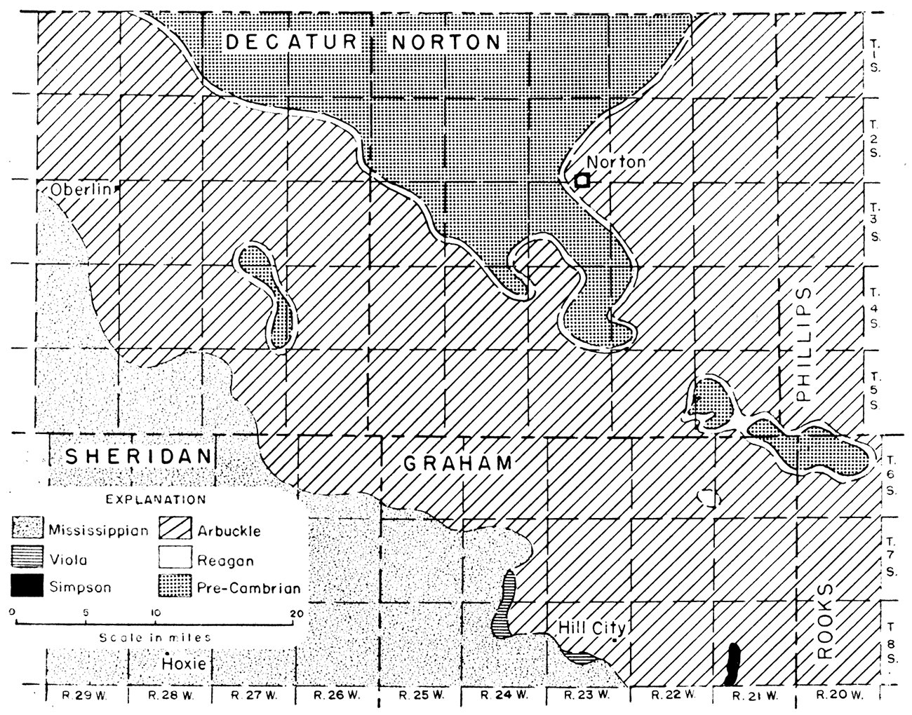
In Norton County the Arbuckle, Reagan, or Pre-Cambrian is overlain by Pennsylvanian beds. Farther to the southwest in Graham, Sheridan, and Decatur Counties, the Arbuckle is overlain either by the Simpson group or the Viola limestone of Ordovician age, or by Mississippian rocks. Figure 4 shows the regional pre-Pennsylvanian areal geology.
Lower Paleozoic rocks are missing and Pre-Cambrian rocks directly underlie Pennsylvanian rocks in three major areas (Fig. 4): (1) on the crest of the Cambridge arch, (2) along the crest of the Jennings anticline in Decatur County, and (3) along the northwestern end of the Central Kansas uplift in the Ray oil field area in southeastern Norton County and northwestern Rooks County. Reagan sandstone is believed to occur directly below Pennsylvanian rocks in a narrow band bordering the areas of Pre-Cambrian rocks, but the continuity of the band is questionable because so few wells penetrate it. The Arbuckle group is in contact with Pennsylvanian rocks over much of the area (Fig. 4) except where the Arbuckle is overlain by Viola limestone in west-central Graham County, the Simpson group in eastern Graham County, and Mississippian rocks in Decatur, Sheridan, and Graham Counties. The major tectonic features are recognizable from the configuration of the pre-Pennsylvanian outcrop pattern.
Figure 4—Pre-Pennsylvanian areal geologic map of the Cambridge arch and vicinity.
The lowest Pennsylvanian beds in the Norton field probably correspond to beds of either the Pleasanton or the Marmaton group. These beds commonly are composed of red and gray sandy shale with interbedded cream to light-gray, dense to finely crystalline, sandy limestone. The basal Pennsylvanian conglomerate is present in a few wells, but its extent is believed to be limited. It is about 10 feet thick in the Harry Gore No. 1 Brunson well in sec. 32, T. 3 S., R. 24 W. The "Gorham" sandstone, a finer grained equivalent of the conglomerate, is reported from a few wells, but also is not extensive. Neither the conglomerate nor the "Gorham" sandstone was present in any well for which samples were available to the Survey.
The Lansing and Kansas City groups consist mainly of limestone with some interbedded shale. The limestone is white, cream, and light gray, dense to finely crystalline, and fossiliferous. Some of the beds are oolitic, some cherty, and some are locally dolomitic. Many of the limestones, especially in the Lansing group, are oil stained. The shale is mostly gray, but some red shale is present. The combined thickness of the two groups is 180 feet (Fig. 2).
The Pedee group is represented by the Weston shale, which consists of red and gray shale and some thin beds of cream to gray, finely crystalline limestone. The group has a thickness of about 35 feet (Fig. 2).
The Shawnee and Douglas groups, not differentiated in this report, are largely limestone with interbedded shale. The limestone is white, cream, and gray, dense to finely crystalline, fossiliferous, and may be cherty or oolitic The shale commonly. is gray and red. The combined thickness of the two groups is about 175 feet (Fig. 2). The black Heebner shale, which occurs in the lower part of the Douglas group, is one of the best marker beds in the Pennsylvanian section. This bed, although only about 4 feet thick, causes a characteristic peak on electric and gamma ray logs. The Topeka limestone occurs at the top of the Shawnee group.
The Wabaunsee group, which is about 225 feet thick (Fig. 2), consists of limestone with interbedded shale and some sandstone. The limestone is gray, cream, and buff, dense to finely crystalline, and fossiliferous. Some beds in this group are cherty and a few are dolomitic. The shale is red and gray. The sandstone that occurs at the base of the group is very fine grained.
The Admire group consists of white to light-brown, finely crystalline limestone which is fossiliferous and interbedded with red and gray shale. The group has a thickness of approximately 90 feet (Fig. 2).
The Council Grove group is composed of shale and limestone. The shale is medium to dark gray and red. The limestone is white to brownish, granular to finely crystalline, and some beds are cherty. The approximate thickness of the group is 310 feet (Fig. 2). The Cottonwood limestone member of the Beattie formation is an excellent marker bed in this group, especially on electric logs.
The Chase group, which is 262 feet thick (Fig. 2), comprises red and green shale and interbedded limestone or dolomitic limestone. The group is characterized by cherty limestones (such as the Wreford which occurs at the base of the group). The limestone is white to brown, granular, soft, and chalky. The dolomitic limestone is brown and finely crystalline.
The Sumner group consists of shale in which salt, dolomite, anhydrite, and gypsum are interbedded. The group is 375 feet thick (Fig. 2). The shale is brick red, pyritic, and sandy. Salt is represented in well samples only by salt molds in the shale. The gypsum is white to clear and crystalline; the dolomite is brown, sandy, and limy; and the anhydrite is white, crystalline, hard, and slightly dolomitic. The most prominent anhydrite is the Stone Corral formation which occurs at the top of the group. This anhydrite, a distinctive marker in the redbeds of western Kansas, is used as a datum for structural mapping and as a reflecting horizon in seismic prospecting.
Only the lower part of the Nippewalla group, which is 460 feet thick (Fig. 2), is present in the Norton field. These redbeds comprise alternating silty shale, very fine-grained sandstone, and thin beds of anhydrite.
The Morrison formation of Jurassic age unconformably overlies the Permian redbed sequence in the Norton field. The Morrison formation is composed of green, sandy shale with some chert and anhydrite and is 160 feet thick (Fig. 2). For distribution of the different lithologic types of the Morrison and a more complete description of the Jurassic rocks in Kansas, the reader is referred to Merriam (in press) .
Upper Cretaceous rocks of the Gulfian Series unconformably overlie the Jurassic Morrison formation.
The Dakota formation, which is about 420 feet thick (Fig. 2), consists mainly of clay, shale, and siltstone and contains some lenticular beds of sandstone. The formation is characterized by siderite pellets which are extremely abundant in well samples.
The Graneros shale, Greenhorn limestone, Carlile shale, and Niobrara formation comprise the Colorado group. The Graneros shale is dark gray to black, fissile, and noncalcareous. It is only 40 feet thick in the Norton field (Fig. 2). The Greenhorn limestone, which is 90 feet thick, is composed of alternating beds of chalky limestone and chalky shale. The Carlile shale is divided into two members: the lower, the Fairport chalky shale member, is calcareous; the upper, the Blue Hill shale member, is dark gray, platy, and noncalcareous. The Codell sandstone bed occurs locally at the top of the Carlile shale. The total thickness of the Carlile shale is 250 feet. The Niobrara formation consists of two members: the Fort Hays limestone (below) and the Smoky Hill chalk (above). The Fort Hays limestone is composed of massive beds of chalky limestone separated by thin beds of chalky shale and shaly chalk. The Smoky Hill chalk is bluish gray and contains thin beds of bentonite.
The Pierre shale of the Montana group is absent in Norton County.
Tertiary rocks unconformably overlie Cretaceous rocks and are represented by the Ogallala formation. The formation is composed of sand, gravel, silt, sandy silt, clay, volcanic ash, and limestone. The clastic material is poorly sorted; where loosely cemented with calcium carbonate it is called "mortar beds." The "Algal limestone," where present, caps the formation (Merriam and Frye, 1954).
The Quaternary System consists of Pleistocene and Recent deposits which are mainly sand, gravel, and silt.
The Norton field is situated on the southeastern end of the Cambridge arch. The Cambridge arch is a large anticlinal feature which lies on the same structural trend as the Central Kansas uplift. The arch, the greater part of which is in Nebraska, derives its name from the town of Cambridge in Furnas Comity, Nebraska. A structural saddle separates the Cambridge arch from the Central Kansas uplift as shown by the configuration on the Pre-Cambrian surface in Figure 3. The areal extent of prePennsylvanian rocks, including Pre-Cambrian, is shown on Figure 4. The pattern of occurrence of the Reagan sandstone delineates fairly well the shape of the arch. On the crest, Pre-Cambrian rocks are overlain directly by Pennsylvanian rocks.
The arch is flanked on both sides by major synclines. The Long Island syncline, on the east side, is a northeasterly plunging structure; the Selden syncline, on the west side, is a northwesterly plunging structure. Tectonically, the Long Island syncline is part of the Salina basin and the Selden syncline is part of the larger Western Kansas basin.
Faulting seems to have played a minor role in the development of structure. According to Landes and Keroher (1942, p. 289), the small faults which occur on the surface probably do not extend very far below the base of the Niobrara. Most of the near-surface faults are normal and are assumed to be tensional. No evidence of faulting was found in the subsurface of the Norton field.
The tectonic history of the Cambridge arch is a series of uplifts and tiltings. Evidence indicates that major movement occurred on the arch several times during early Paleozoic time. Tilting prevailed until the end of Permian time when, possibly, there was orogenic movement. Differential movement and tilting occurred during Mesozoic time followed by orogenic folding which took place near the end of Cretaceous time. Little is known about early Tertiary structural movement, but tilting occurred after the deposition of the "Algal limestone" bed of the Ogallala formation of Pliocene age (Merriam and Frye, 1954).
The structural relationships of the beds are shown in an eastwest cross section of Norton County (Pl. 1). The Derby Oil Company No. 4 Schoen well in sec. 35, T. 3 S., R. 24 W., well 4 on the cross section, is the only well shown that is located in the Norton field. The lower Paleozoic beds are present on the flanks of the Cambridge arch in a wedge-shaped mass thickening away from the crest. The Reagan sandstone as a sheet deposit unconformably overlies the Pre-Cambrian and in turn is conformably overlain by the Arbuckle. Because neither well 7 nor 8 was drilled through the Arbuckle, it is not known whether the Reagan is present at these locations. Prior to the deposition of the Pennsylvanian sediments the area of the Cambridge arch was uplifted and the Reagan and Arbuckle were stripped off the crest, exposing the Pre-Cambrian. Because of the absence of rock section between the Arbuckle and the Pennsylvanian, it is impossible to determine the sequence of events that took place during this interval.
The basal Pennsylvanian conglomerate is present in well 3 on the cross section (Pl. 1) and rests unconformably on the Arbuckle. It is not known whether this bed was developed only locally or was deposited extensively and subsequently eroded. The relation of Pennsylvanian to older Paleozoic rocks seems to indicate that the arch was topographically high during the deposition of the basal part of the Pennsylvanian sediments. In general, rocks below the base of the Kansas City group abut against the arch rather than thin over it.
The base of the Kansas City group is readily recognized on the electric logs and is used as a datum plane. However, the base of the Kansas City group here probably does not correspond to the base of the group as recognized farther east in Kansas (Wallace Lee, personal communication).
Above the base of the Kansas City group the thicknesses of the Pennsylvanian and Permian rocks remain fairly constant so that the Stone Corral formation is probably a good indicator of Pennsylvanian structure in the vicinity of the Cambridge arch.
The Jurassic and Cretaceous beds unconformably overlie Paleozoic rocks. Because there was movement of the Cambridge arch during Cretaceous time, these rocks should also reflect structure at depth but to a lesser degree. In other words the structure should become more sharply defined and steeper with depth. This relationship was found also by Lee and Merriam (1954).
The Cretaceous, in turn, is unconformably overlain by Tertiary and Quaternary sediments that are not shown on Plate 1.
Structure maps of the Norton field were prepared for four horizons: (1) the top of the Stone Corral formation (Pl. 2A), (2) the top of the Lansing group (PL 2B), (3) the base of the Kansas City group (Pl. 2C), and (4) the top of the Arbuckle group (Pl. 2D). The detailed pre-Pennsylvanian areal geology of the field is shown on Plate 2D. The maps, contoured at 5-foot intervals, show the producing wells, dry holes, abandoned wells, and drilling locations, and contain all data up to and including August 1954.
The structure of the Norton field, as shown by the Stone Corral formation (Pl. 2A), is an elongate northeast-southwest trending anticline of low relief. The southeast flank is steeper than the northwest flank. There are three small areas of closure on the structure; the maximum closure is about 7 feet. One area that shows synclinal closure is located in the SW sec. 36, T. 3 S., R. 24 W. The configuration of the contours shows that the structure in the Norton field is highly irregular.
The structure map drawn on the top of the Lansing group (Pl. 2B) reveals structure similar to that shown on the Stone Corral structure map. A northeast-southwest, slightly elongated anticline of low relief is suggested by the 5-foot contours. The southeast flank of the structure is more pronounced than the northwest flank and there are areas of flattening along the crest of the anticline.
The structure map on the base of the Kansas City group (Pl. 2C) is similar to the other two structure maps, but more sharply defined. A northeast-southwest elongated anticline having maximum closure of 7 feet is shown by the contours in the SE sec. 35, T. 3 S., R. 24 W. The southeast flank is steeper than the northwest. The plunge of the anticline to the northeast and the southwest is about 20 feet to the mile. The configuration of the contours reveals the irregularity of the structure.
Plate 2D presents the structure on top of the Arbuckle group and the pre-Pennsylvanian areal geology. There exist structural similarities to the higher horizons. There is an elongated northeast-southwest trending anticline of low relief with the southeast flanks steeper than the northwest. The anticline plunges both northeastward and southwestward about 20 feet to the mile. The structure is irregular and has four small areas of closure, the maximum being about 10 feet. The minor irregularities of the structure are believed to be the result of erosion. Because the Arbuckle is absent on the northwest flank it is not possible to determine the original extent of the structure. The Reagan sandstone occurs as a narrow band between the Arbuckle, on the southeast, and the Pre-Cambrian, on the northwest. The Reagan outcrop seems to swing around the northern end of the structure but control is not adequate to determine just where this takes place. The Arbuckle is absent in the D. G. Hansen No. 5 Weber well in the SW SW SE sec. 30, T. 3 S., R. 23 W., but the Reagan was encountered at a depth of 3,743 feet.
A study of the relation of structure to depth indicates that the axis of the structure shifts southeastward with depth and that the fold increases in intensity with depth. This southeastward shift between the top of the Stone Corral and the top of the Arbuckle amounts to about a quarter of a mile. The areas of closure seem to be random at each horizon, although there is a slight increase in the amounts of closure with depth.
As the anticline is of low structural relief, it probably was not the controlling factor in oil accumulation. The plunge on the northeastern and southwestern sides of the structure was important in keeping the oil from migrating laterally.
It is not the purpose of this report to outline future possibilities for oil in the area or to recommend new drilling locations, but rather to explain the geological conditions under which the oil has been trapped. Although the field is not completely outlined at this time, it is felt that the development and data are sufficient to warrant some preliminary conclusions. Three dry holes have been drilled along the northwestern side of the field and another well has been temporarily abandoned, so that this side of the field is fairly well defined. One dry hole on the southwestern edge and two along the southeastern edge indicate that the limits on these sides of the field are being approached. No dry holes have yet been drilled on the northeastern side of the field.
Oil accumulation is limited to sedimentary beds in both the Arbuckle and Reagan rocks. These strata form a wedge-shaped mass between the Pre-Cambrian basement and the overlying Pennsylvanian sediments. The angular unconformity between the Pennsylvanian and older strata represents a long interval of time. While this surface was exposed to erosion, considerable porosity must have been developed in the dolomitic Arbuckle. Therefore, on the northwestern side there is an erosional truncation of the reservoir beds, augmented by a decrease of porosity. The oil could not have been trapped until after the deposition of the Pennsylvanian sediments which formed a seal over the porous reservoir.
The northeastern and southwestern sides of the field seem to be limited by the plunge of the eroded anticline. There was sufficient structure to prevent lateral migration of the oil once it had been stopped by truncation along the northwestern flank of the anticline.
The southeastern side of the Norton field continues as regional dip. Thus, the controlling factor for the entrapment of the oil is the lowest closing contour of the anticlinal structure. The structural closure as such is small, but, if the effect of the wedge-out on the northwest flank is considered, the structure might have as much as 25 feet of closure. The drainage area for the field, therefore, includes not only the field itself but also the area to the southeast. Once the structure filled, the oil would tend to migrate laterally until stopped by another barrier. In regard to this, it would be expected that the oil might tend to "back up" and "mound" down dip on the southeastern flank, so that the producing area would extend below the lowest closing contour. This would explain production from some of the wells along the southeastern side of the field.
The similarity of this area to the Central Kansas uplift where the weathered and deeply eroded Arbuckle has been a prolific source of oil, especially where it is directly overlain by Pennsylvanian rocks, is immediately recognized. However, this is not the only feature that the two areas have in common. The structural development of both the Central Kansas uplift and the Cambridge arch are closely parallel, except that the Cambridge arch had continued movement for a considerable time after the Central Kansas uplift had become quiescent.
During the last 6 months of 1953, the prorated Norton field produced 41,694 barrels of oil, a daily average of 339 barrels. During the first 8 months of 1954, production was 379,422 barrels of oil, a daily average of 1,620 barrels. At the end of August 1954, there were 97 producing wells and 6 wells were being drilled in the field. Development drilling in the field has been steady since its discovery. Production from the field for 1954 will exceed half a million barrels of oil.
Byrne, F. E., Beck, H. V., and Bearman, C. H., (1949) Construction materials in Norton County, Kansas: U. S. Geol. Survey, Circ. 24, pp. 1-16. [available online]
Frye, J. C., and Leonard, A. R. (1949) Geology and ground-water resources of Norton County and northwestern Phillips County, Kansas: Kansas Geol. Survey, Bull. 81, pp. 1-144. [available online]
Goebel, E. D. (1953) The petroleum industry in Kansas: Kansas Geol. Survey, Oil and Gas Investi. No. 10, Map. [available online]
Hay, Robert (1885) Preliminary report on the geology of Norton County, Kansas: Kansas Acad. Sci. Trans., vol. 9, pp. 17-24.
Landes, K. K., and Keroher, R. P. (1942) Mineral resources of Phillips County: Kansas Geol. Survey, Bull. 41, pt. 8, pp. 277-312. [available online]
Lee, Wallace, and Merriam, D. F. (1954) Preliminary study of the structure of western Kansas: Kansas Geol. Survey, Oil and Gas Investi. No. 11, 23 p. [available online]
Merriam, D. F. (In press) Jurassic rocks in Kansas: Am. Assoc. Petroleum Geologists Bull.
Merriam, D. F., and Atkinson, W. R. (In press) Tectonic history of the Cambridge arch in Kansas: Kansas Geol. Survey, Oil and Gas Investi. No. 13, 32 p. [available online]
Merriam, D. F., and Frye, J. C. (1954) Additional studies of the Cenozoic of western Kansas: Kansas Geol. Survey, Bull. 109, pt. 4, pp. 49-64. [available online]
Moore, R. C., and others (1951) The Kansas rock column: Kansas Geol. Survey, Bull. 89, pp. 1-132. [available online]
Ver Wiebe, W. A. (1942) Exploration for oil and gas in western Kansas during 1941: Kansas Geol. Survey, Bull. 42, pp. 1-123.
Ver Wiebe, W. A. (1943) Exploration for oil and gas in western Kansas during 1942: Kansas Geol. Survey, Bull. 48, pp. 1-88.
Ver Wiebe, W. A. (1944) Exploration for oil and gas in western Kansas during 1943: Kansas Geol. Survey, Bull. 54, pp. 1-104.
Ver Wiebe, W. A. (1945) Exploration for oil and gas in western Kansas during 1944: Kansas Geol. Survey, Bull. 56, pp. 1-112.
Ver Wiebe, W. A. (1946) Exploration for oil and gas in western Kansas during 1945: Kansas Geol. Survey, Bull. 62. pp. 1-112.
Ver Wiebe, W. A. (1947) Exploration for oil and gas in western Kansas during 1946: Kansas Geol. Survey, Bull. 68, pp. 1-111.
Ver Wiebe, W. A., and others (1948) Oil and gas developments in Kansas during 1947: Kansas Geol. Survey, Bull. 75, pp. 1-230.
Ver Wiebe, W. A., and others (1949) Oil and gas developments in Kansas during 1948: Kansas Geol. Survey, Bull. 78, pp. 1-186.
Ver Wiebe, W. A., and others (1950) Oil and gas developments in Kansas during 1949: Kansas Geol. Survey, Bull. 87, pp. 1-176.
Ver Wiebe, W. A., and others (1951) Oil and gas developments in Kansas during 1950: Kansas Geol. Survey, Bull. 92, pp. 1-187.
Ver Wiebe, W. A., and others (1952) Oil and gas developments in Kansas during 1951: Kansas Geol. Survey, Bull. 97, pp. 1-188.
Ver Wiebe, W. A., and others (1953) Oil and gas developments in Kansas during 1952: Kansas Geol. Survey, Bull. 103, pp. 1-201.
Ver Wiebe, W. A., and others (1954 Oil and gas developments in Kansas during 1953: Kansas Geol. Survey, Bull. 107, pp. 1-204.
Kansas Geological Survey
Placed on web June 20, 2019; originally published Dec. 15, 1954.
Comments to webadmin@kgs.ku.edu
The URL for this page is http://www.kgs.ku.edu/Publications/Bulletins/109_9/index.html