Kansas Geological Survey, Open File Report 96-50
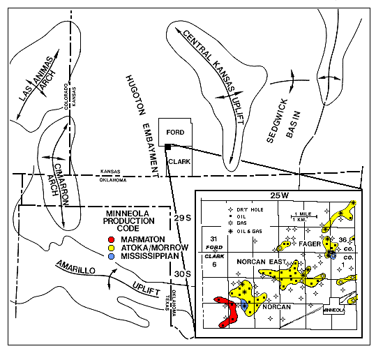
Figure 1--Index map of study area showing the Hugoton embayment and other major tectonic features. Individual fields and associated production in the Minneola complex are shown in the insert (from Clark, 1987).
Although both 2-D and 3-D seismic has been used successfully for identifying the channels in which the Morrow sandstones occur (Clark, 1987, 1995; Montgomery, 1996) it has met with limited success in determining whether the channels contain potentially productive sandstones, or are simply filled with shale , siltstone, or tight sandstones and conglomerates. This is particularly a problem for the Minneola complex because the productive sandstones are relatively thin and occur in northwest-southeast barrier bar trends that are separated laterally by non-productive intervals in the Morrow (Clark, 1987, 1995; Fig. 3). Because of this, drilling a well within a seismically identified channel does not necessarily mean it will encounter potentially productive sandstone, even if the channel is relatively thick.
The goal of this report is to use seismic well log modeling to determine if it is possible for seismic data to differentiate a channel that is completely filled with non-productive material such as shale, from one that contains a potentially productive sandstone. Results from this study suggest that differentiating sand from shale is possible with high-resolution seismic imaging, provided the frequency bandwidth is relatively wide, the noise levels are relatively low, and well control is used to help identify the type of seismic anomaly to look for.