 |

|
Kansas Geological Survey Open-file Report 2003-33 |
Depth to Arbuckle Saline Aquifer
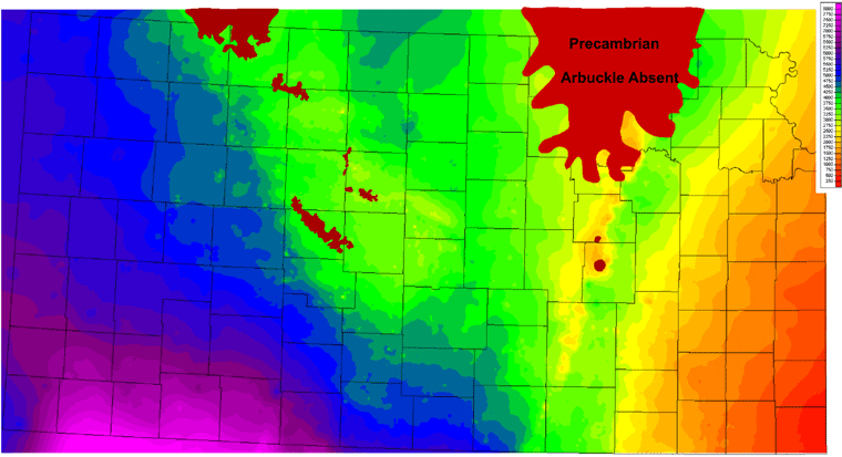
 Colored
contour map of measured depth from surface to top of the Arbuckle Group
based 67,014 horizon picks from oil and gas wells. Areas in brick red are
where the carbonates of the Arbuckle Group were removed by Mississippian-Pennsylvanian
erosion and Middle Pennsylvanian or younger rocks rest directly on the Precambrian.
Measured depths range from more than 8000 feet (2438m) in southwest Kansas
to less than 250 feet (76m) in the southeast. (Contour Interval 250 feet)
Colored
contour map of measured depth from surface to top of the Arbuckle Group
based 67,014 horizon picks from oil and gas wells. Areas in brick red are
where the carbonates of the Arbuckle Group were removed by Mississippian-Pennsylvanian
erosion and Middle Pennsylvanian or younger rocks rest directly on the Precambrian.
Measured depths range from more than 8000 feet (2438m) in southwest Kansas
to less than 250 feet (76m) in the southeast. (Contour Interval 250 feet)
|
|
|
e-mail : webadmin@kgs.ku.edu
Last updated June 2003
http://www.kgs.ku.edu/PRS/publication//2003/2003-33/P1-06.html
Last updated June 2003
http://www.kgs.ku.edu/PRS/publication//2003/2003-33/P1-06.html