KGS Home Geology Home Start of Core Studies book

Kansas Geological Survey, Open-file Report 91-52, p. 35-55


Lithologies and depositional environments of the Pennsylvanian reservoir sandstone at Campo and Tanner fields, Baca County, southwestern Colorado

Craig D. Caldwell

Phillips Petroleum Company
Bartlesville, Oklahoma

Abstract

Campo and Tanner fields, south-central Baca County, Colorado (fig. 1), discovered in 1982 and 1985, respectively, have produced approximately 1 million barrels of oil from a southwest-northeast-trending, faulted anticline. The primary reservoir in the two adjacent fields is a Pennsylvanian (Desmoinesian or Missourian) sandstone. The sandstone and immediately overlying and underlying strata were cored in two wells, one from each field (figs. 2 and 3). The wireline-log character of the cored intervals is shown in figs. 4 and 5.

Figure 1--Location of study area and major Middle and Late Pennsylvanian physiographic and tectonic features of the southern midcontinent.

Study area in southeastern Colorado, south of Las Animas arch; west of Hugoton embayment, east of Apishapa-Sierra Grande uplift, north of Keyes dome.

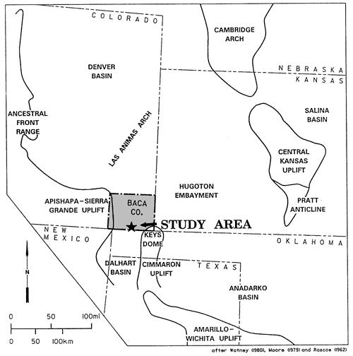
Figure 2--Core diagram of Cities Service Kearley A-2. [An Acrobat PDF version of this figure is available.]

Core descriptions, core analysis data, minerals found, and lithology for Cities Service Kearley A-2.

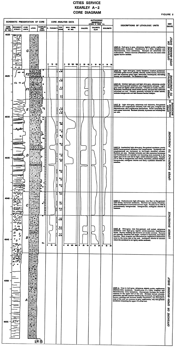
Figure 3--Core diagram of Cities Service Womack B-1. [An Acrobat PDF version of this figure is available.]

Core descriptions, core analysis data, minerals found, and lithology for Cities Service Womack B-1.

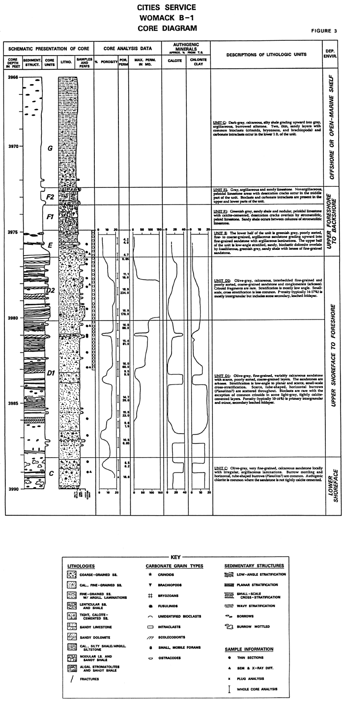
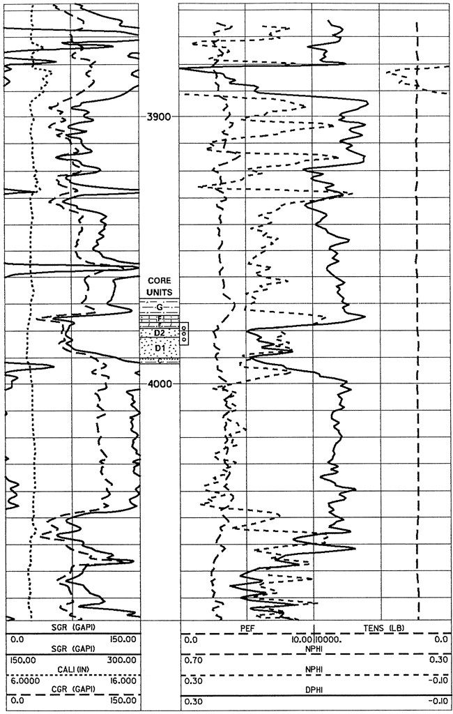
Figure 4--Compensated neutron-lithodensity log of the Cities Service Kearley A-2 showing wireline-log character of core units (core depth = wireline log depth).

Gamma ray and neutron-density log for Cities Service Kearley A-2.

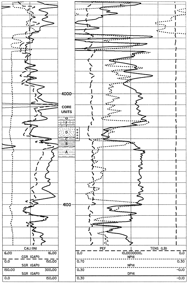
Figure 5--Compensated neutron-lithodensity log of the Cities Service Womack B-1 showing wireline-log character of core units (core depth + 2 ft = wireline log depth).

Gamma ray and neutron-density log for Cities Service Womack B-1.

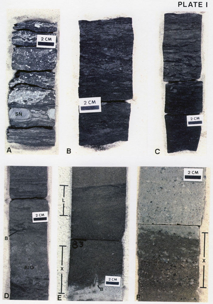
Strata underlying and gradational to the reservoir sandstone are light-colored, well-sorted, calcareous, very fine grained, burrowed (predominately Planolites) sandstone (core unit B) grading downward into gray to dark-gray, fossiliferous, slightly pyritic, argillaceous siltstone and silty shale (core unit A) (plate I A-D). These rocks record a gradual shoaling from an open-marine, offshore, shelf environment (unit A) to a more landward, shallower, relatively low-energy, lower shoreface environment (unit B) (fig. 6).

Figure 6--Paleoenvironmental interpretation for the main Pennsylvanian reservoir sandstone and immediately underlying and overlying strata, Campo and Tanner fields, Baca County, Colorado (Womack B-1 and Kearley A-2 cores).

Block diagram showing paleoenvironmental conditions in area of two cores.

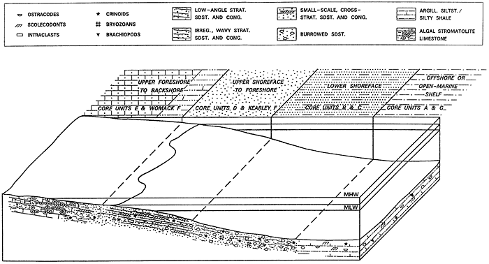
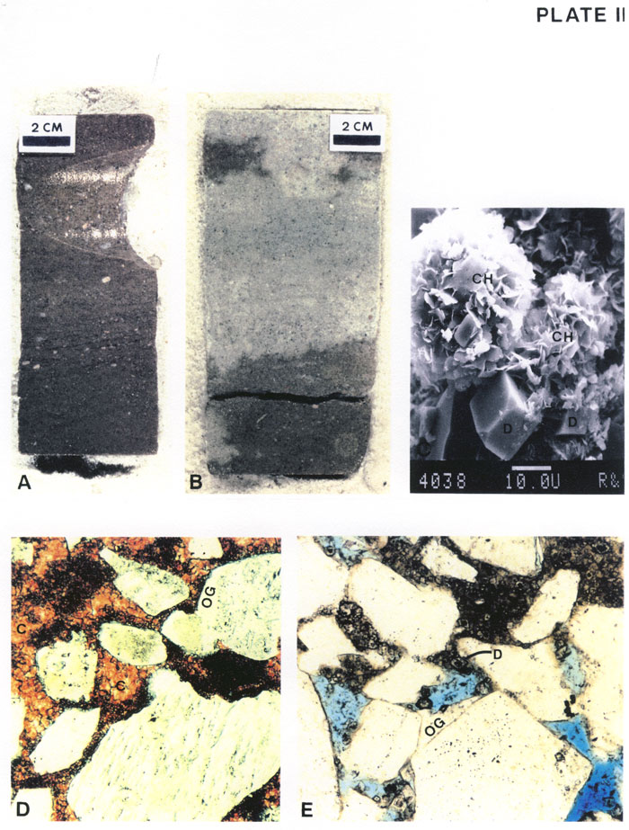
The reservoir sandstone is approximately 14 ft (4.3 m) thick in each of the two cored wells. The sandstone is predominately planar and low-angle stratified, and less commonly, small-scale cross stratified, fine-grained sandstone and similarly stratified, very coarse grained sandstone and conglomerate (core unit D) (plates I [E-F] and II [A-B]). The lowermost part of the reservoir is a burrowed, fine-grained sandstone (core unit C). The reservoir sandstone reflects a transition from lower shoreface (unit C) through upper shoreface/surf zone to foreshore/beach swash zone (unit D). Mineralogically immature, arkosic sediments composing the sandstones were shed off the emergent Apishapa-Sierra Grande uplift a few tens of kilometers to the west. Core porosities over much of the reservoir sandstone are 10-15%. Porosity types include primary intergranular and minor, secondary, leached feldspar. Primary intergranular porosity is variably occluded by finely to coarsely crystalline, equant calcite cement, authigenic chlorite clay, and minor amounts of quartz and feldspar overgrowths (plate II [C-E]).

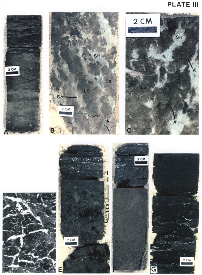
The reservoir sandstone is gradationally overlain by low-porosity, variably fossiliferous, poorly sorted, fine- to coarse-grained sandstone with common argillaceous laminations and partings (core unit E) (plate III A). This argillaceous sandstone records upper foreshore and possibly backshore deposition and continued shoaling of the underlying siliciclastic sequence. Gradationally overlying these rocks is a 1-2.5-ft (0.3-0.76-m)-thick interval of argillaceous and sandy limestone, including bioclastic washed packstone, stromatolitic and intraclastic limestone, and nodular limestone with desiccation cracks (core unit F) (plate III [B-F]). These carbonates reflect a decrease in siliciclastic influx and deposition in upper foreshore/backshore to possibly upper shoreface environments (fig. 6).

Dark-gray, silty and calcareous shale and argillaceous siltstone, with fossil assemblage dominated by ostracodes and scolecodonts (core unit G) (plate III G), rest abruptly on the underlying carbonates. These dark, argillaceous rocks indicate a marine deepening and return to quiet-water, offshore, shelf deposition. This deepening may be related to eustatic rise in sea level or the fore-mentioned decrease in siliciclastic influx, ending seaward progradation of the described beach-shoreface sequence.

Plate I--Core units A-D

[Note: An Acrobat PDF file containing all of the plates is available.]

  1. Gray, fossiliferous shale of core unit A, Kearley A-2 (4,050 ft, 11 inches, to 4,051 ft, 5 inches). Bioclasts are predominantly crinoid columnals and brachiopods. Siderite(?) nodules (SN) are indicated.
  2. Gray, burrowed, argillaceous siltstone/very fine grained sandstone composing the upper part of core unit A, Kearley A-2 (4,047 ft to 4,047 ft, 5 inches).
  3. Gray to dark-gray argillaceous siltstone/very fine grained sandstone of core unit A overlain by fine- to very fine grained, light-gray, burrowed sandstone of core unit B, Kearley A-2 (4,046 ft, 4 inches, to 4,047 ft).
  4. Light-gray, fine-grained sandstone of core unit B, Kearley A-2 (4,045 ft, 2 inches, to 4,045 ft, 10 inches) displaying burrows (B), a bioturbated area (BIO), and in the upper part of the sample, parallel lamination.
  5. Small-scale cross-stratified (X) and low-angle stratified (L), fine-grained sandstone of core unit D, Womack B-1 (3,982 ft, 7 inches, to 3,983 ft, 4 inches). Greenish-gray sandstone composing the lower part of the sample is tightly calcite cemented. A burrow (B) occurs at the top of the tightly cemented layer.
  6. Cross-stratified (X), poorly sorted, coarse-grained sandstone of core unit D overlain by greenish-gray, poorly sorted, argillaceous sandstone of the lowermost part of core unit E, Womack B-1 (3,976 ft, 5 inches, to 3,977 ft).

Six color photos of core.

Plate II--Core unit D

  1. Cross-stratified and low-angle stratified, generally fine-grained sandstone with scattered very coarse sand and granule-size, detrital grains, core unit D, Kearley A-2 (4,036 ft, 4 inches, to 4,036 ft, 9 inches).
  2. Greenish-gray, tightly calcite-cemented sandstone overlying olive-gray, porous sandstone, core unit D, Womack B-1 (3,983 ft, 6 inches, to 3,983 ft, 11 inches).
  3. Scanning electron microscope photomicrograph of authigenic, chlorite clay (CH) and finely crystalline dolomite (D) in intergranular pore of unit D sandstone, Kearley A-2 (4,038 ft) (scale bar is 10 microns).
  4. Tightly calcite-cemented, fine- to very coarse grained sandstone of core unit D, Kearley A-2. Calcite cement (C) is stained red by alizarin red S. Some detrital grains display overgrowths (OG) formed prior to calcite cementation (80x).
  5. Porous, fine- to very coarse grained sandstone of core unit D, Kearley A-2. Preserved intergranular porosity is filled by blue epoxy. Intergranular areas in the upper part of the photo are filled or partially filled by authigenic, chlorite clay and finely crystalline dolomite (D). Quartz overgrowth (OG) is shown (80x).

Two color photos of core, a black and white photomicrograph, and two color thin-section photos.

Plate III--Core units E-G

  1. Fine- to coarse-grained sandstone of core unit E, Kearley A-2 (4,028 ft, 11 inches, to 4,029 ft, 6 inches). Gray, argillaceous lamination is common in the upper part of this sample.
  2. Gray, algal limestone (LS) and greenish-gray, sandy shale (SH) of core unit F, Womack B-1 (3,973 ft, 5 inches, to 3,974 ft, 3 inches). The limestone has a digitate character with sandy shale filling the intervening areas. Calcite-filled fractures and/or dessication cracks (C) are present in the shale and limestone.
  3. Close-up photo of algal limestone (LS) and sandy shale (SH), core unit F, Womack B-1 (3,973 ft, 5 inches, to 3,973 ft, 8 inches). The limestone is characterized by algal stromatolites (A).
  4. Thin-section photomicrograph of calcite-cemented dessication cracks (C) in limestone of core unit F, Womack B-1 (3,974 ft, 10 inches) (30x).
  5. Sandy, lithoclastic limestone (LLS) abruptly overlying argillaceous, sandy limestone with darker, irregularly shaped areas of fenestral limestone, unit F, Womack B-1 (3,972 ft, 5 inches, to 3,973 ft, 2 inches). The lithoclastic limestone grades upward into sandy, bioclastic and lithoclastic shale composing the lower part of core unit G.
  6. Tight, sandy, bioclastic limestone (washed packstone) of core unit F abruptly overlain dark-gray, fossiliferous, silty mudstone/argillaceous siltstone of core unit G, Kearley A-2 (4,023 ft, 11 inches, to 4,024 ft, 7 inches).
  7. Dark-gray, fossiliferous, silty shale of core unit G, Womack B-1 (3,971 ft to 3,971 ft, 9 inches). Macroscopic bioclasts are predominantly brachiopods.

Seven color photos of core.


Kansas Geological Survey
Comments to webadmin@kgs.ku.edu
Web version created June 28, 2012. Original publication date 1991.
URL=http://www.kgs.ku.edu/PRS/publication/1991/OFR91_52/Caldwell1/index.html