
Sedimentology and lithostratigraphy of the Upper Mississippian Ste. Genevieve and St. Louis Limestones, southwestern Kansas
by
F. E. Abegg
Department of Geology, University of Kansas, and Kansas Geological Survey
Lawrence, Kansas 66047
Abstract
A core from the Mobil #1 Foster (sec. 5, T. 34 S., R. 36 W.) in Stevens County, Kansas, contains six facies that are representative of the St. Louis (Meramecian) and Ste. Genevieve (Chesterian) Limestones across much of the Hugoton embayment: 1) peloid grainstone/packstone, 2) anhydrite, 3) dolomite, 4) skeletal packstone/wackestone, 5) oolitic grainstone/packstone, and 6) quartzose grainstone.
An abundance of peloids, evaporites, and paucity of stenohaline marine organisms in the lower St. Louis indicate that the peloid grainstone/packstone, anhydrite, and dolomite facies were deposited in a restricted lagoon. Subadjacent oolitic facies suggest shoals created barriers to circulation. Periodic winnowing, interbedded oolites, and a diverse and abundant fauna of echinoderms, brachiopods, and bryozoans indicate upper St. Louis skeletal packstone/wackestone was deposited in a shallow-marine environment at or near normal wavebase. Upper St. Louis oolitic grainstone/packstone, the reservoir facies, accumulated in a highly agitated, marine-shoal environment, probably at depths less than 5 m.
Two quartzose grainstone intervals in the upper St. Louis and Ste. Genevieve contain excellent examples of eolian stratification. These two eolian intervals are separated by subtidal strata. Both eolian units overlie shoaling-upward successions and are underlain by lithoclast deflation conglomerates containing reworked calcrete clasts. The lower eolian interval consists almost exclusively of low-angle (less than 7°), climbing-translatent stratification produced by the migration of wind ripples. Calcretes with abundant rhizoliths are also present. Rhizoliths and low-angle climbing-translatent strata indicate a poorly vegetated, eolian sand sheet. In contrast, the upper eolian interval is thicker (9.4 ft or 2.9 m), lacks rhizoliths, and consists of abundant eolian climbing-translatent, common grainfall and minor grainflow stratification in cross-strata sets up to 1.5 ft (0.5 m) thick with dips as high as 24°. Cross strata and absence of vegetation in the upper eolian interval indicate deposition by migrating eolian dunes.
The base of the St. Louis is marked by a shift from shoaling-upward, shallow-marine carbonates of the Salem to restricted, peloidal carbonates and anhydrite of the lower St. Louis. A relative rise in sea level results in renewed deposition of shallow-marine limestone in the upper St. Louis. Progressively thicker oolitic intervals cap shoaling-upward cycles in the uppermost St. Louis, suggesting progradation or aggradation of high-energy shoals. Ste. Genevieve eolian quartzose grainstone is intercalated with subtidal limestone. The overlying Shore Airport Formation consists of argillaceous, peloidal limestone punctuated by numerous shaly paleosols.
Introduction
Mississippian strata in Kansas are confined to the subsurface, with the exception of outcrops of Burlington-Keokuk Limestone (Osagian) in two townships of Cherokee County, in the extreme southeastern comer of the state (Thompson and Goebel, 1968). Upper Mississippian lithostratigraphic nomenclature of the Mississippi Valley region was originally extended to the subsurface of Kansas by Lee (1940) and Clair (1948, 1949), and most recently updated by Goebel (1968) and Thompson and Goebel (1963, 1968).
Previous studies used insoluble residues and biostratigraphy extensively to define lithostratigraphic units. It is more practical to base definitions on the more abundant carbonate fraction that is observable in cores and cuttings, or indicated with certain wireline logs. Formations are rock-stratigraphic units (i.e. lithofacies) and accordingly biostratigraphic data only help to constrain lithostratigraphic correlations. Recent advances in carbonate petrology, sequence stratigraphy, and additional subsurface data warrant an update of existing Upper Mississippian lithostratigraphic definitions and interpretations of depositional environments in southwestern Kansas. Increased understanding of Upper Mississippian facies, lithostratigraphy, and depositional history should improve hydrocarbon exploration and production from these strata.
Previous investigations
According to Lee (1940), upper Meramecian and Chesterian strata of southwestern Kansas were first penetrated in Clark County by the Watchorn Oil and Gas Company #2 Morrison in 1931. Strata of "late Meramecian age" in southwestern Kansas were initially grouped into the Watchorn Formation "where subdivision of ... the Spergen [Salem], St. Louis, and possibly Ste. Genevieve limestones is impracticable" (Lee, 1940, p. 8485). Lee relied heavily on insoluble residues to assist in recognition of Mississippian units. In the same report, Girty (1940) reported on the megafossils of the Watchorn and unnamed Chesterian strata.
Clair (1948, 1949) subsequently divided the Watchorn into three formations using Mississippi valley nomenclature. Recognition of the Ste. Genevieve, St. Louis, and Spergen (Salem) Limestones was based primarily on lithologic criteria. Chesterian strata were not named due to lithologic heterogeneity (Clair, 1948, 1949; Beebe, 1959a, b).
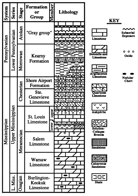
Thompson and Goebel (1963, 1968) and Goebel (1968) defined Mississippian strata using a combination of lithologic criteria, insoluble residues, and conodont biostratigraphy. Previously the Ste. Genevieve Limestone was placed within the Meramecian Stage (e.g., Thompson and Goebel, 1963, 1968; Zeller, 1968). Recently, however, Maples and Waters (1987) redefined the Meramecian-Chesterian boundary, placing the Ste. Genevieve at the base of the Chesterian Stage, a usage followed in this report (fig. 1).
Figure 1--Upper Mississippian lithostratigraphic units in the Hugoton embayment in western Kansas. Shore Airport Formation (Abegg, in prep. (a)) and "Gray group" (Youle, this volume) are new names. No scale intended.
Regional geology and stratigraphy
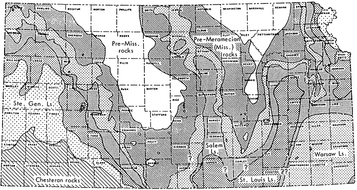
The Mississippian System is preserved only between positive Late Mississippian-Early Pennsylvanian tectonic features (fig. 2). Mississippian strata were subaerially exposed and extensively eroded prior to deposition of Lower Pennsylvanian strata. Ste. Genevieve and St. Louis strata were deposited on a carbonate shelf that extended southward from the Transcontinental arch. Deposition of argillaceous carbonates and siliciclastics in the overlying Shore Airport Formation marks the termination of dominantly carbonate shelf deposition that continued throughout much of Mississippian time (Lane and DeKeyser, 1980).
The Ste. Genevieve and St. Louis Limestones were named for exposures in the western Illinois basin in eastern Missouri. In the type area, the St. Louis is primarily a mud-rich carbonate, generally interpreted to have been deposited in restricted lagoonal to tidal flat or sabkha settings (Jorgensen and Carr, 1973; Martorana, 1987). The overlying Ste. Genevieve is oolitic. Ste. Genevieve oolitic carbonates of the Illinois basin are a primary hydrocarbon target, whereas the St. Louis is generally unproductive. In ft Hugoton embayment of southwestern Kansas, however, the upper St. Louis oolites are a major hydrocarbon reservoir, whereas the Ste. Genevieve is generally unproductive.
Ste. Genevieve and St. Louis strata of the Illinois basin and southwestern Kansas share many similarities; however, differences between the two areas exist. Lithologic similarities and entrenched usage in the literature and in the petroleum industry appear to warrant continued use of these formational names in Kansas. This paper aims to update facies descriptions and standardize stratigraphic terminology, as well as increase our understanding of the depositional history for the St. Louis and Ste. Genevieve Limestones.
As used in this report, the Salem is characterized by dolomitic skeletal and oolitic limestones. The overlying St. Louis is often divisible into two informal members (fig. 2). The lower St. Louis contains primarily peloidal limestone, dolomite, and anhydrite. Upper St. Louis strata are dominantly skeletal limestone. Additionally, uppermost St. Louis strata contain oolitic limestone. This usage differs from the type area where oolitic limestone is included in the Ste. Genevieve. Ste. Genevieve strata are recognized by the lowest prominent quartz-rich limestone. The overlying Shore Airport Formation (Abegg, in prep. (a)) consists primarily of argillaceous limestone and intercalated shale.
Figure 2--Subcrop map of Mississippian strata beneath the sub-Pennsylvanian unconformity in Kansas (from Thompson and Goebel, 1968).
Methods
This study examines Upper Mississippian strata in the Hugoton embayment of the Anadarko basin in southwestern Kansas (fig. 2). Thirteen cores were examined in detail (table 1). These cores were selected primarily because most contain greater than 100 ft (30 m) of strata while providing a wide areal extent. Several other shorter cores have also been examined in order to evaluate lateral variability. A total of 2,904 ft (885 m) from these 13 cores (table 1) have been characterized. These data will be presented elsewhere (Abegg, in prep. (b)). Cores were logged at a scale of 1:12 or 1:24. Carbonate textures were described using the classification scheme of Dunham (1962). A total of 491 thin sections were also examined from these cores. In order to facilitate recognition of detrital siliciclastic gains, dolomite crystals, and ferroan cements, many of these thin sections were stained with Alizarin Red-S and potassium ferricyanide.
Table 1--Location and depths of core logged in this study.
| Well | Location | County | Core Depth (ft) |
|---|---|---|---|
| Alma #1 Watchorn | C SW NE, 13-15S-33W | Logan | 4445-4646 |
| Shallow Water #4 Maune | C NE NW, 31-21S-33W | Finney | 4628-4775 |
| Pan American #1 Moser | C NW NW, 31-24S-36W | Kearny | 4960-5235 |
| Amoco #3 Cohen C | C SE NE, 27-25S-38W | Kearny | 5226-5459 |
| Pendleton #1 Schauf | SW SW NE, 16-27S-29W | Gray | 4956-5080 |
| Cities Service #1 Kells B | C NW NW, 05-28S-34W | Haskell | 5590-5710 |
| Amoco #1 Puyear | 660'FWL 1980'FSL, 23-28S-40W | Stanton | 5454-5716 |
| Amoco #1 Nordling | SW SE NE, 30-29S-39W | Stanton | 5650-6030 |
| Amoco #3 Wilson A | SE SE NW, 30-30S-33W | Haskell | 5310-5818 |
| Amoco #1 Breeding F | SW, 34-3 1 S-40W | Morton | 5040--5416 |
| Mobil #1 A. W. Foster | C NE SW, 05-34S-36W | Stevens | 6625-6910 |
| Colorado #2 Fox A | C NE SE, 03-35S-30W | Meade | 6240-6299 |
| Mobil #1 Headrick | SW NW, 03-35S-37W | Stevens | 6733-6911 |
Four east-west and five north-south cross sections were constructed to evaluate lateral variability of the Upper Mississippian units. These data will be presented separately (Abegg, in prep. (b)). Wells that penetrate the maximum thickness of Mississippian strata were selected. Gamma ray-neutron-density are the most informative logs, as they most accurately determine lithologic variability. Cores allow calibration of log signatures to lithologies. Cross sections were hung on the top of the Ste. Genevieve because this is the most consistent Mississippian log pick. This presents a problem, however, in a few wells where the top of the Ste. Genevieve has been removed by subsequent erosion associated with the sub-Pennsylvanian unconformity. In these cases, the logs were hung on the top of the Mississippian.
Ste. Genevieve and St. Louis reference section
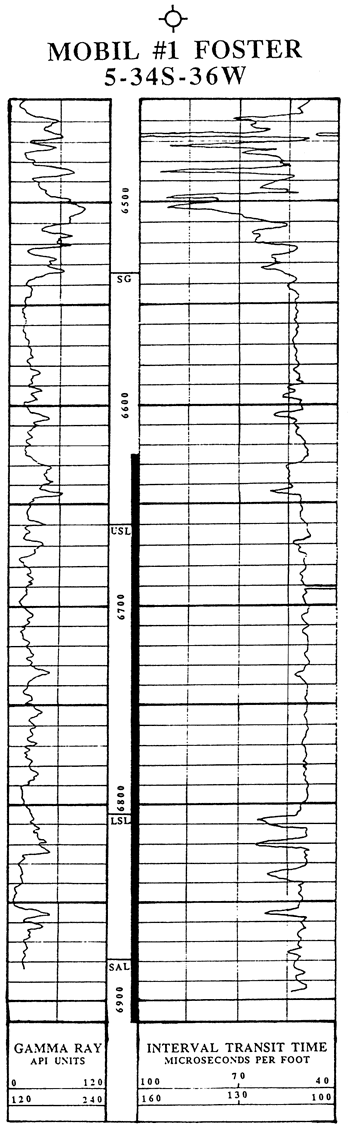
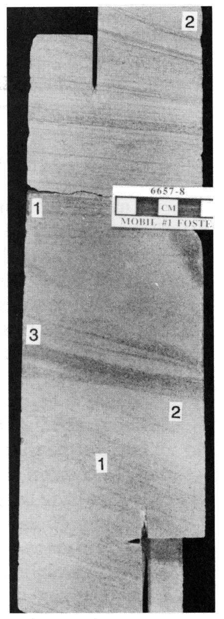
In order to facilitate better lithostratigraphic definitions of the St. Louis and Ste. Genevieve, a core from the #1 Foster (C NE SW, sec. 5, T. 34 S., R. 36 W.) in Stevens County, Kansas, will be formerly designated as reference section for these units (Abegg, in prep. (c)). This core is currently housed at the Kansas Geological Survey in Lawrence, Kansas. Two-hundred and eighty-five feet (87 m) of uppermost Salem, St. Louis, and Ste. Genevieve were cored from 6,625 to 6,910 ft (core depth). Log depths and core depths are approximately coincident (fig. 3). The reference core contains both the lower and upper boundaries of the St. Louis. The contact of the Ste. Genevieve and the overlying Shore Airport Formation was not cored. In addition to stratigraphic completeness, this core was selected because it is available to the general public and contains facies representative of these formations over much of the Hugoton embayment.
Figure 3--Gamma ray-sonic log from the Mobil #1 Foster (sec. 5, T. 34 S., R. 36 W.), Stevens County, Kansas. Tops are picked from a combination of core studies and cross section correlations. Cored interval is indicated in depth track. Depths in feet.
A core will be designated as the reference section because both the Ste. Genevieve and St. Louis do not crop out anywhere in the state. Ste. Genevieve strata are also preserved in the subsurface of the Hugoton embayment in southwestern Kansas and the Forest City basin in northeastern Kansas (Thompson and Goebel, 1968). St. Louis strata have a much wider distribution, occurring in the Hugoton embayment and in the Forest City, Cherokee, Salina, and Sedgwick basins (Tbompson and Goebel, 1968). The nearest St. Louis outcrop is in a downfaulted block along the Chesapeake fault in southwestern Dade and eastern Barton counties, southwestern Missouri (Clark, 1937). The nearest outcrops of Ste. Genevieve strata are in the Mississippi Valley region of eastern Missouri.
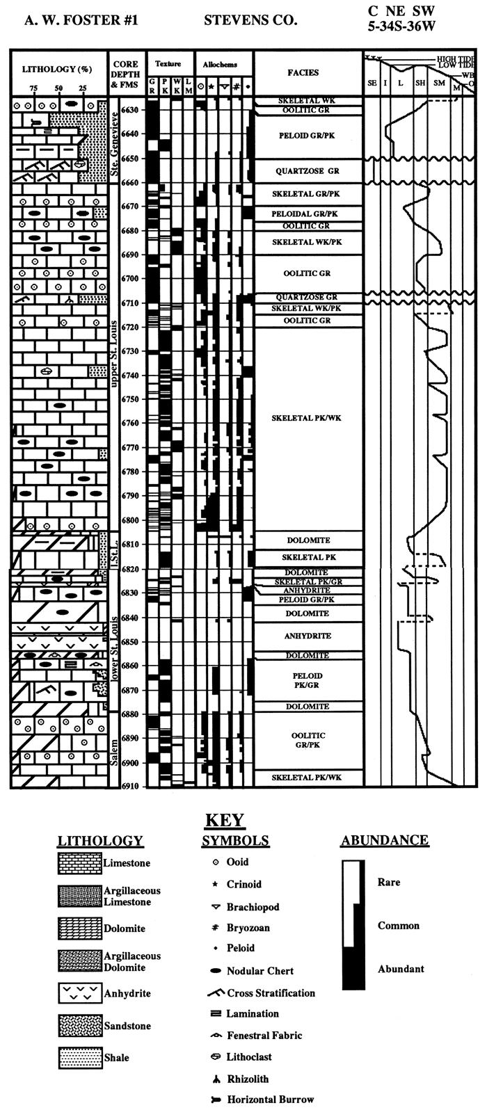
Reference section facies
Six lithofacies are recognized in the Mobil # 1 Foster core (fig. 4): 1) peloid grainstone/packstone, 2) anhydrite, 3) dolomite, 4) skeletal packstone/wackestone, 5) oolitic grainstone/packstone, and 6) quartzose grainstone.
Figure 4--Description of core from the Mobil #1 Foster. Core depths are roughly equivalent to log depths. Right-hand track shows interpretations of shifts in depositional environments. Dashed lines represent shifts without accompanying deposition. Horizontal wavy lines are subaerial exposure surfaces or surfaces bracketing eolian strata. Abbreviations used include the following: SE--subaerial exposure; I--intertidal or tidally influenced; L--restricted lagoon/shelf; SH--oolitic or skeletal shoal; SM--shallow marine with evidence of at least intermittent agitation, above or near wavebase (WB); M--marine with little winnowing, below wavebase; O--oxygen-minimum zone, separates dysaerobic and anaerobic facies from overlying aerobic facies (not represented in core). Depositional textures are abbreviated: GR--grainstone, PK--packstone, WK--wackestone, LM--lime mudstone. Formations (FMS) and members are listed in the depth track.
Peloid grainstone/packstone
Peloids are abundant to common and are the dominant allochem in this facies. Echinoderms are rare to common. Additional allochems are rare and include brachiopods, bryozoans, ostracodes, calcispheres, sponge spicules, and intraclasts. Very fine sand detrital quartz comprises 510% of this facies; feldspar, muscovite, glaucony, amphibole, and organic fragments are rare. This facies contains 5-70% (most commonly 5-30%) replacive dolomite. Dolomitization is fabric selective, preferentially replacing the micritic fraction. Bluish-gray chert is present in some horizons and is commonly associated with casts of sponge spicules. This suggests a local biogenic source for much of the silica. Cubic pyrite is scattered throughout much of the facies.
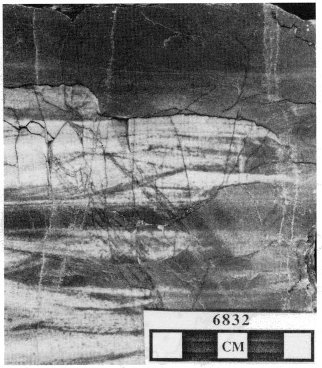
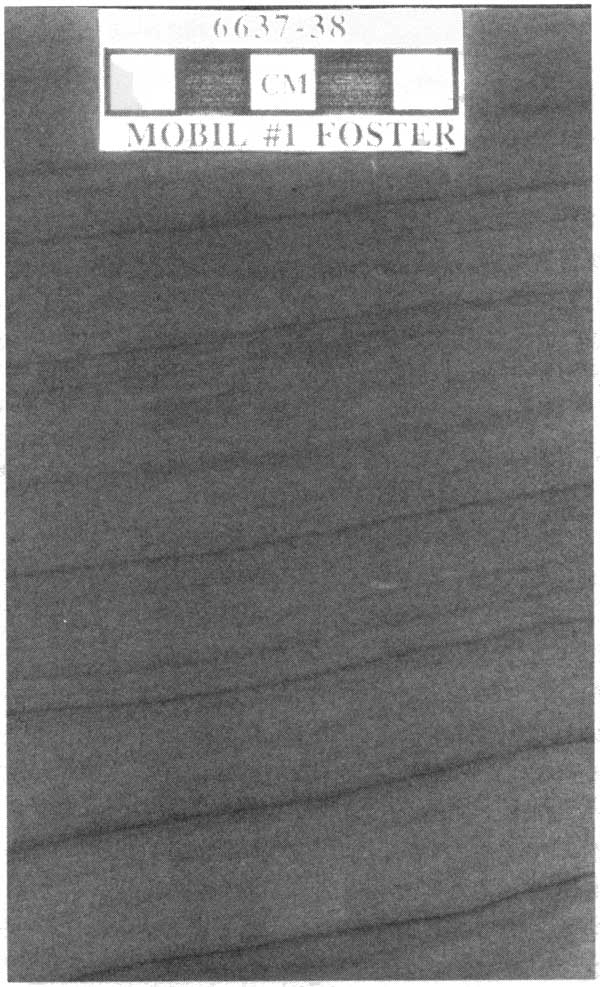
Many intervals are marked by parallel laminae. Some strata are ripple cross laminated (fig. 5A). In the Ste. Genevieve at 6,637-6,638 ft, core depth, laminae rhythmically thicken and thin (fig. 5B). Horizontal, feeding trace fossils are present in some horizons. Possible cryptalgal laminae, oncolites, microfenestral porosity, and autoclastic breccias are present where rocks of this facies occur immediately underneath the anhydrite facies.
Figure 5--Peloid grainstone/packstone facies in the Mobil #1 Foster. (A) Ripple-cross laminations highlighted by chert. 6,832 ft core depth. (B) Systematic thickening and thinning of laminae might indicate tidal influence. 6,637-6,638 ft core depth.
Much of the interparticle porosity has been destroyed by compaction. Sutured stylolites are common, but unsutured stylolite swarms are more abundant. Any remaining porosity was totally occluded by equant calcite cement.
Peloid grainstone/packstone is interstratified with ooid grainstone/packstone, nodular anhydrite, skeletal packstone/wackestone, or quartzose grainstone (fig. 4).
Interpretation
The abundance of peloids, paucity of stenohaline marine organisms, and association with evaporites suggest deposition in a restricted shelf setting. Subadjacent oolitic shoals are interpreted to have formed a barrier restricting connections with open-marine waters. Predominance of parallel laminae and micritic matrix indicate low energy. Ripple cross laminae and uncommon grainstones indicate periods of increased agitation. Rare cryptalgal laminae, oncolites, microfenestral? porosity, and autoclastic breccia suggest shallow water or briefly emergent conditions. Diagnostic evidence for subaerial exposure, however, is absent.
Anhydrite
Two anhydritic intervals occur in the basal St. Louis in the reference core. In southwestern Kansas, preserved anhydrite is restricted to portions of Morton, Stanton, Hamilton, Stevens, Grant, Seward, Haskell, and possibly Meade counties. As many as 13 separate anhydrite beds have been recognized from density logs.
Anhydrite structures in the reference section are predominantly mosaic, nodular-mosaic, and massive (fig. 6, cf. Maiklem et al., 1969). Nodular, bedded-nodular, bedded-mosaic, and crystallotopic structures also occur. In thin section, anhydrite textures are mostly felted, with lath-shaped texture occurring less frequently (cf. Maiklem et al., 1969). Blocky crystals are observed in anhydrite-filled fractures. Crystals are highly birefringent with vivid second-order colors. Many of the evaporite intervals contain little or no matrix; carbonates are usually interbedded between anhydrite intervals. Anhydrite nodules are outlined by thin, brown, dolomitic peloidal carbonates. Nodules are generally ellipsoidal and irregularly arranged. Obvious stratification or bedding are virtually absent. Notably absent are upward-oriented anhydrite nodules, generally interpreted as relict, subaqueous gypsum crystals (cf. Loucks and Longman, 1982). Anhydrite is commonly partially replaced by light-blue, length-slow, spherulitic chalcedony (cf. Folk and Pittman, 1971) and rarely by euhedral authigenic quartz. Highly birefringent anhydrite relicts are uncommon in the chalcedony and quartz.Figure 6--Anhydrite structures from the lower St. Louis in the Mobil #1 Fosster. Massive (M), mosaic (Mo), and nodular-mosaic (not shown) (cf. Maiklem et al., 1969) are the most abundant structures. 6,842-6,844 ft core depth.

In the Mobil #1 Foster core, anhydrite beds are intercalated with dolomitic peloid grainstone/packstone, dolomite, and skeletal packstone/wackestone (fig. 4).
Interpretation
Nodular to mosaic anhydrite is often genetically associated with sabkha environments (Keff and Thomson, 1963). Numerous authors, however, have indicated such associations are not always warranted (Dean et al., 1975; Warren and Kendall, 1985; Warren, 1989). Other differences exist between sabkha and subaqueous evaporites (table 2). The thickness and lack of significant carbonate matrix of the anhydrite, as well as interbedded, shallow-water carbonate, indicate deposition in a shallow subaqueous environment. Diagnostic features indicating subaerial exposure are notably absent.
Table 2--Distinguishing features of sabkha and subaqueous evaporites (from Warren, 1989, his table 3.1).
| Sabkha | Shallow Water |
|---|---|
| Evaporite units are supratidal, matrix dominated, usually <60% sulfate | Evaporite units are subaqueous, relatively pure, often >70% sulfate |
| Each evaporite (supratidal) depositional unit is thin, usually 1-2 m | Each evaporite (subaqueous) unit is thick, 1-20 m |
| Displacive and replacive nodular and enterolithic textures | Bottom-nucleated evaporite crystal textures; often laminated, laminae can be laterally continuous, but do not extend across the whole basin |
| Evaporite crystals are diagenetic | Deposition can be mechanical; evaporites contain clastic textures; gypsolites, wave and current ripples, crossbeds, rip-up breccias, reverse and normal graded beds |
| Associated with sabkha tepees, flat-laminated and polygonal algal mats | Associated with ground-water tepees, laminar algal mats, and domal subaqueous stromatolites |
| Facies units tend to be laterally extensive, parallel to shoreline; deposited as a "peritidal" trilogy (cf. Warren and Kendall, 1985) | Facies often symmetric or asymmetric bull's-eye patterns; sometimes as vertical aggrading facies |
| Carbonate matrix washed in from lagoon during storms; sands can be blown in from adjacent sand seas (ergs) | Carbonate facies outline areas of less saline water in basin; vadose pisolites can be common in such areas |
| Hydrology dominated by storm recharge and shallow brine reflux | Hydrology dominated by evaporite drawndown and deeper brine reflux |
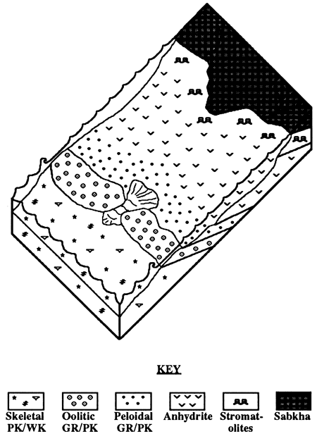
The common Salem-lower St. Louis vertical succession (in ascending order) of skeletal packstone/wackestone, ooid and skeletal grainstone, laminated peloid packstone, capped by anhydrite, suggests progradation of shallow-water facies (fig. 7). The ooid shoals are interpreted to have restricted circulation in a back-barrier lagoonal environment. Interbedded carbonates and an absence of halite suggest either a minor but continuous influx of marine waters or a periodically breached barrier due to storms and/or small-scale fluctuations in sea level.
Figure 7--Block diagram of depositional environments depositing upper Salem and lower St. Louis facies. Oolitic shoals restricted marine circulation enough to precipitate gypsum but not halite. Most evaporites are interpreted as shallow subaqueous in origin and were most likely bordered by sabkhas. Obvious intertidal and supratidal features are rare. Stromatolites, interpreted to be largely subtidal in origin, occur locally in many Upper Mississippian cores and are interbedded with both anhydrite and subtidal strata. Possible cryptalgal laminites are present in the Mobil #1 Foster below the anhydrite from 6,855-6,850 ft core depth. Tidal channel is shown between ooid shoals. GR--grainstone; PK--packstone; WK--wackestone.
Based on a neutron-density log from the Amoco #1 Puyear (sec. 23, T. 28 S., R. 40 W.), the thickest known individual St. Louis anhydrite interval is 62 ft (19 m) thick. Given a 38% volume loss from conversion of gypsum to anhydrite, the corresponding original gypsum thickness was 100 ft (30 m). A continuous or periodic influx of marine waters is needed to provide such a thick evaporite bed, as a completely evaporated 1,000-m column of seawater will yield only 0.75 m of gypsum (Blatt et al., 1980). Based on such estimates, the evaporation of an equivalent of a 40,000-m seawater column would be required to produce a 19-m (62-ft) anhydrite interval. Such thick evaporites are inconsistent with a sabkha model.
Thick anhydrite indicates an and to semi-arid climate during the late Meramecian. This is consistent with Cecil's (1990) interpretations of Late Mississippian climates based on multiple lines of evidence. Cecil suggests and climates persisted throughout the Meramecian and into the early Chesterian. A more humid climate toward the end of the Mississippian reflects the northward migration of North America (Scotese, 1986).
Upon burial, the transformation of gypsum to anhydrite occurs at depths as shallow as 300 m (9,485 ft) and is often complete at depths of 1,300 m (4,265 ft) (Murray, 1964; Blatt et al., 1980; Warren, 1989 ). The exact depth depends on the geothermal gradient and the salinity of the enclosed brine (Blatt et al., 1980). Anhydrite is the stable phase at temperatures greater than 60°C.
As stated earlier, a 38% loss of solid volume accompanies the replacement of gypsum by anhydrite. Slow drainage of dehydration fluids permits the sediment to retain rigidity (Warren, 1989), forming of crudely aligned, nodular anhydrite pseudomorphs after gypsum (Loucks and Longman, 1982; Schreiber et al., 1982; Shearman, 1985; Warren and Kendall, 1985; Warren, 1989). Matrix impurities are needed to outline these original crystal forms. The absence of these features in most St. Louis anhydrites may be attributable to rapid dewatering or an absence of significant matrix in some horizons.
Dolomite
Many carbonates in the lower St. Louis are dolomitic (fig. 4). However, only a few are extensively dolomitized. This facies is defined as strata containing greater than approximately 70% dolomite, which typically obscures the original depositional texture. Dolomitization is highly fabric selective, preferentially replacing the micritic fraction of the rock. Three types of dolomite are recognized. The majority of the dolomite typically consists of finely crystalline (10-15 mm), limpid crystals with euhedral to planar-s texture (cf. Sibley and Gregg, 1987). Floating within this finely crystalline dolomite are coarser (up to 350-mm) dolomite rhombs with a planar-e texture. These rhombs often contain cloudy cores and clear rims. Saddle dolomite (nonplanar) cements with sweeping extinction are uncommon. Dolomitization has obliterated most grains, but crinoids, brachiopods, fenestrate bryozoans, and peloids are preserved in a few beds indicating marine deposition. Interbedded, less dolomitized carbonates contain crinoids, brachiopods, bryozoans, foraminifera, intraclasts, and peloids.
Up to 10% detrital quartz sand and silt is present in some horizons. Rare chert nodules contain only planar-e crystals. Parallel laminae are common in many horizons and are locally disrupted by horizontal burrows (fig. 8). Sutured and unsutured stylolites and fractures filled with calcite and anhydrite cement occur locally.
The dolomite facies is interbedded with the anhydrite, peloid grainstone/packstone, and skeletal packstone/ wackestone facies (fig. 4). In addition, underlying Salem carbonates are commonly dolomitic.
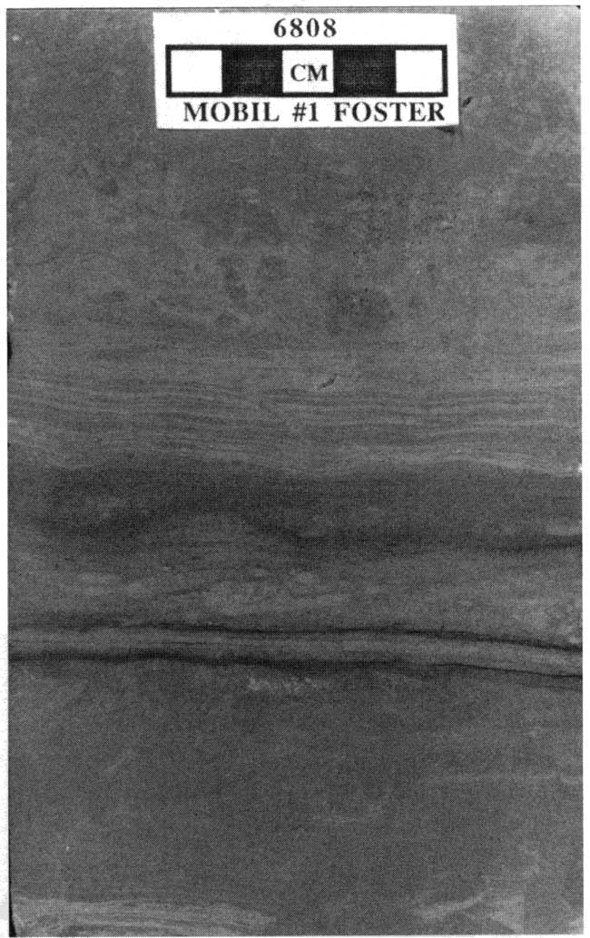
Figure 8--Dolomite faciess from the lower St. Louis in the Mobil #1 Foster. Parallel laminae are partially to totally disrupted by burrows. 6,808 ft core depth.
Interpretation
Common lamination and detrital quartz suggest some dolomitized beds are altered peloid packstone. Because dolomitization is fabric selective, however, dolomitized packstone and grainstone are likely to be less dolomitized because of a paucity of micrite. Therefore, extensively dolomitized facies most likely had a micrite-rich precursor. The fine-grained nature of much of the dolomite supports such an interpretation. Because only planar-e dolomite crystals are present in chert, this indicates chertification postdates planar-e dolomite crystallization and predates planar-s and nonplanar dolomite crystalfization.
Dolomitic carbonate in the St. Louis is restricted to the lower member and to intervals adjacent to or laterally correlative to the anhydrites. Upper St. Louis strata contain little or no dolomite, even though micrite-bearing facies are present. This relationship suggests evaporitic brines were responsible for much of the dolomitization, possibly due to refluxing lagoonal brines and/or connate brines expressed during compaction. Minor baroque dolomite indicates deeper burial dolomitization. Additional investigation is needed to determine the genesis of lower St. Louis dolomite.
Skeletal packstone/wackestone
This is the most extensive facies in the upper St. Louis Limestone. Abundant to rare allochems include echinoderms and bryozoans. Common to rare allochems include brachiopods and ooids, and rare allochems include rugose and tabulate corals, bivalve? and gastropod casts, trilobite fragments, foraminifera (mainly endothyrids), ostracodes, siliceous sponge spicules, and worm tubes (fig. 9). Detrital quartz is generally absent to very rare, but makes up to 20% of the rock locally. Horizontal burrows are common in some intervals, whereas vertical burrows are rare. Truncated allochems, often capped by a vaguely laminated peloidal micritic crust, occur along subhorizontal truncation surfaces locally in mud-poor packstones (fig. 10).
Figure 9--Skeletal packstone/wackestone from the upper St. Louis in the Mobil #1 Foster. Microstylolites (M), burrows (Bu), bryozoans (Br), solitary rugose coral (RC), and crinoids (C) are indicated by arrows. 6,747-6,748 ft core depth.
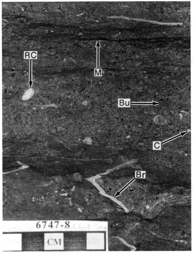
Figure 10--Two hardgrounds in skeletal and oolitic, mud-poor packstones. Note the relief on the upper hardground surface. The upper hardground is overlain by a vaguely laminated peloidal crust (arrow) that is possibly algal in origin.
Skeletal packstone/wackestone is commonly gray to tan. Chert is generally rare and typically bluish gray in color. Sponge spicules, now casts filled by sparry calcite and silica cement, provide a biogenic source for much of the silica. Absence of significant grain interpenetration within chert nodules and deflection of stylolites around chert nodules indicate that chert is precompactional. Dolomite is a minor constituent and is best developed proximal to anhydrites. Microstylolites, and less commonly sutured stylolites, are present throughout much of this facies (fig. 9). Sutured and concavo-convex interpenetrating grain contacts indicate significant pressure solution. Porosity was originally restricted to spar-rich packstones. No porosity remains, however, because primary intergranular pores were totally occluded by sparry calcite cement and compaction.
Many skeletal packstone/wackestone intervals are overlain by oolitic grainstone/ packstone. The skeletal packstone/wackestone facies is also intercalated with the dolomite, anhydrite, and peloid grainstone/ packstone facies of St. Louis, and the quartzose grainstone of the Ste. Genevieve (fig. 4).
Interpretation
The diverse and abundant assemblage of stenohaline echinoderms, brachiopods, and bryozoans indicate deposition in a normal-marine environment. Periodic winnowing and intercalated oolites suggest deposition at or near normal wavebase. An abundance of horizontal trace fossils, characteristic of the Cruziana ichnofacies, is also consistent with shallow-marine deposition. Truncation surfaces are interpreted as marine hardgrounds.Oolitic grainstone/packstone
Well-sorted, very fine to medium-grained ooids dominate this facies (fig. 11). Ooid cortices have a radial-concentric microstructure and are generally unbroken and unabraded. Other allochems are rare and include echinoderms, brachiopods, bryozoans, gastropods, foraminifera, ostracodes, and lithoclasts. Detrital quartz is present only as nuclei of a few ooids.
Figure 11--Ooid grainstone from the upper St. Louis. Note scattered lithoclasts (arrow). Because crinoids, and to a lesser degree brachiopods, nucleate cements more readily than ooids, ooid grainstones with even a minor fraction of uncoated crinoids are typically tight.
Sedimentary structures are uncommon in many of the oolites. Unidirectional very low-angle cross stratification to parallel lamination are present locally. Truncated ooids and bioclasts, often capped by a vaguely laminated peloidal micritic crust, occur along subhorizontal truncation surfaces locally (fig. 10). Isopachous bladed cements are commonly well developed below the truncation surface, but are absent above.
This facies is the reservoir facies for most St. Louis producing intervals. Extant porosity is generally slightly solution-enlarged, cement-reduced interparticle. Syntaxial and equant cements (cf. Choquette and Pray, 1970) penetrate into adjacent gains indicating that some of the calcite cement is precompactional. Dissolution, albeit minor, appears to have occurred in two stages. The first dissolutional event predates equant cements. A second dissolution event truncates all previous diagenetic phases and may be related to hydrocarbon migration (Youle, 1990).
Oolitic grainstone or packstone commonly have gradational lower boundaries and many are underlain by skeletal packstone or wackestone. The upper contact of the ooid grainstone/packstone facies is either abrupt or somewhat gradational and is usually overlain by skeletal packstone or wackestone, and rarely by quartzose grainstone and peloid grainstone/packstone (fig. 4).
Interpretation
The dominance of ooids and grainstone texture, minor cross stratification, and scattered, stenohaline marine fossils indicate this facies accumulated in a highly agitated, marine environment. Modern ooids generally form at depths less than 6 ft (2 m), with the majority of ooid-rich facies being deposited in depths less then 15 ft (5 m) (Newell et al., 1960). Near-absence of cross stratification may indicate bioturbation. Vaguely laminated, peloidal, micritic crusts on oolitic truncation surfaces (fig. 10) may be algal in origin, suggesting they formed with the aid of substrate-stabilizing algal mats (Gebelein, 1969). Dravis (1979) reports algae were important in the formation of oolitic hardgrounds in the Bahamas. Isopachous bladed cements that are present only below the hardground may be marine in origin.
Quartzose grainstone
This is the most abundant facies in the Ste. Genevieve Limestone. Allochems are almost invariably broken and well rounded, irregardless of their original shape. Detrital quartz is not as well rounded as carbonate grains. Common grains include peloids, echinoderms, bryozoans, and ooids. In contrast to the ooid grainstone/packstone facies, ooid cortices are commonly noticeably abraded. This was originally reported by Clair (1948, 1949) as "elliptical rather than round" ooids. Some echinoderm fragments contain extremely well-rounded syntaxial overgrowths. Brachiopods, foraminifera, and lithoclasts are rare. Glauconitic grains are scattered throughout. Detrital quartz sand varies between 5 and 30% and is mostly very fine grained, although grain size ranges from very coarse silt to medium sand. Quartzose grainstones can often be recognized on wireline logs by a separation in the neutron and density curves. Other detrital grains are rare, including feldspar, zircon and amphibole.
Acid etching and polishing of slabbed cores, as well as thin-section petrography indicate grain types are grain-size dependent. The very coarse-silt to very fine-sand fraction consists primarily of detrital quartz and peloids with a minor bioclastic fraction. The fine- to medium-sand fraction consists of common bioclasts and ooids with a relatively minor peloid and quartz abundance.
Three stratification types are recognized in the Mobil #1 Foster from this facies: 1) coarsening-upward strata, 2) indistinctly stratified intervals, and 3) fining-upward to structureless strata.
Coarsening-upward strata
Coarsening-upward strata, commonly 2-5 mm thick, but as thick as 9 mm (fig. 12), are the first and most common type of stratification. The coarsening-upward nature is best observed where stratification is thickest. The basal 1 mm of each stratum contains minor very coarse silt and abundant very fine sand grains of detrital quartz and peloids with rare scattered bioclasts. Fine to medium sand grains are rare. Microstylolites, sutured grain contacts, and a paucity of calcite cement at the base of the coarsening-upward stratum indicate significant chemical compaction. The coarser grained top portion consists of very fine to medium sand grains composed primarily of bioclasts and ooids admixed with quartz and peloids. In contrast to the fine-grained base, the uppermost coarser part of the stratum contains more abundant equant and syntaxial overgrowth sparry calcite cement, with fewer interpenetrating grain contacts. Ripple-foreset laminae are prominent only where coarsening-upward units are thickest and are best observed on polished or acid-etched surfaces. Coarsening-upward strata commonly dip at angles less than 7°, but some dip as steeply as 24°. In quartzose grainstone with dips less than 10° in the Mobil #1 Foster core, this is the dominant type of stratification. Coarsening-upward stratification also dominates the base of cross-strata sets (sets up to 0.5 ft or 0.5 m in thickness) where dip angles are low and is intercalated with other stratification types in the more steeply dipping, upper portions of these cross-strata sets.
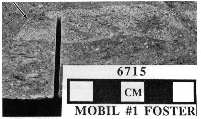
Figure 12--Upper St. Louis quartzose grainstone from the Mobil #1 Foster consisting of low-angle type 1 or eolian climbing-translatent stratification dipping at approximately 6°. The strata are unusually thick (up to 9 mm), coarsen upward, and contain well-developed ripple-foreset laminae. Direction of ripple migration is down the slope or to the right. Note the vertical rhizolith (arrow). 6,707 ft core depth.
Indistinctly stratified intervals
The second stratification type is indistinctly stratified (fig. 13), with dips of 10° to 20°. Stratification, commonly highlighted by microstylolites, is difficult to distinguish because most of these deposits are very well sorted, very fine sand, but grains up to medium sand are present. Indistinctly stratified intervals are most abundant in the more steeply dipping (>10°), upper portions of cross-strata sets. This stratification type is intercalated with coarsening-upward and fining-upward to structureless strata.
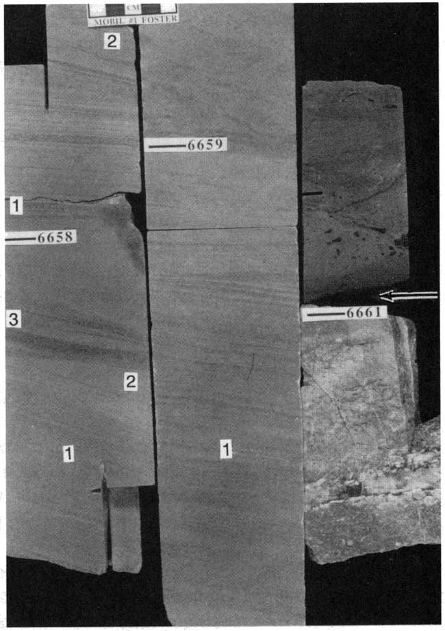
Figure 13--Ste. Genevieve quartzose grainstone from the Mobil #1 Foster displaying three stratification types. Climbing-translatent strata (1) are composed of 2-5 millimeter thick, distinctly coarsening-upward units. Ripple-foreset laminae are developed only in the thicker strata. Grainfall (2) units consist of very fine to fine sand that is vaguely stratified due to the excellent sorting. Grainflow (3) toes are fining upward, not as well sorted, and thin downward. The lower surface of the grainflows is concave-upward, reflecting the preflow depositional surface. Dip of the grainflows is an apparent dip; true dip is greater than 20°. 6,657-6,658 ft core depth.
Fining-upward to structureless strata
Fining-upward to generally structureless intervals of very fine to medium sand comprise the third stratification type (fig. 13). This type of stratification is rare in Ste. Genevieve cores. The bottom and top of these deposits are commonly sharp. The base is typically slightly irregular; underlying, strata are locally truncated at a low angle. Thickness ranges from 2 to 16 mm, and individual units thin by as much as 4 mm across a 3.5-inch (8.9-cm) core. Sorting is not as good in this type of stratification as in the types described above. Several of these intervals fine upward; the base is marked by a thin (< 1-mm-thick) medium-sand layer that thickens as the stratum thins. Internal primary sedimentary structures are absent. Dips of fining-upward to structureless strata in the Mobil #1 Foster are as high as 24° and always exceed 20°. Fining-upward to structureless stratification is restricted to the uppermost parts of cross-strata sets and is interstratified with both coarsening-upward strata and indistinctly stratified intervals.
Two quartzose grainstone intervals are present in the Mobil #1 Foster, and both cap shoaling-upward successions (fig. 4). The lower interval occurs in the upper St. Louis and is 3.8 ft (1.2 m) thick (fig. 14). This quartzose grainstone is included in the upper St. Louis because it is very thin. The upper interval marks the base of the Ste. Genevieve and is 9.4 ft (2.9 m) thick (fig. 15).
Figure 14--Upper St. Louis quartzose grainstone from the Mobil #1 Foster deposited as a vegetated eolian sand sheet. Note the dark-brown rhizoliths in the two separate calcretes (C). Calcretes are overlain by lithoclast conglomerates containing reworked calcrete clasts (arrows). The strata are almost exclusively composed of climbing-translatent strata dipping at angles of less than 7°. 6,706-6,710 ft core depth.
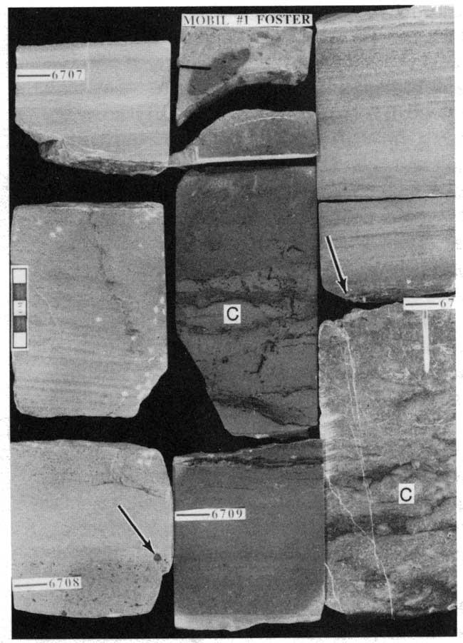
Figure 15--Quartzose grainstone from the Mobil #1 Foster. The base of the lithoclast conglomerate (arrow) at 6,661 ft core depth is the St. Louis-Ste. Genevieve boundary. Abundance of cross-stratification sets and absence of rhizoliths indicates deposition took place in an active dune field. The majority of stratification is climbing translatent (1), but grainfall (2) and rare grainflow strata (3) also occur. 6,657-6,661 ft core depth.
Calcite-cemented tubes coated by indistinctly laminated, dark-brown micrite occur directly beneath the quartzose grainstone in the upper St. Louis. Identical tubes are also found within the immediately overlying quartzose grainstone. The majority of the tubes are subhorizontally oriented. A few, usually somewhat larger tubes, are vertically oriented. Some of these tubes bifurcate downward with smaller diameters in the branches, although this is rare. Tubes and micritic coatings are commonly less than 1 mm in diameter and exceed 0.3 ft (0.1 m) in length. Intervals containing these tubes range from 0.4 to 0.6 ft (0.1-0.2 m) thick. Some of the calcite-filled tubes are divided by thin micritic walls. Tangential and random needle-fiber calcite cements are closely associated with intervals containing these tubes. Brownish, bladed, sparry-calcite cement is also common within intervals containing calcite-filled tubes. Much of this cement is upward-oriented (astropetal). This cement nucleates from the base of horizontal sheet cracks as thin semicontinuous layers extending laterally for up to 1.25 in (31 mm). Crystals grew upward into open pore space and commonly have euhedral terminations. Uncommonly, however, the terminations of these cements are rounded.
The base of each quartzose grainstone is marked by a lithoclastic conglomerate. The thickness of these conglomerates ranges from 0.04 to 0.65 ft (0.01-0.2 m). Lithoclasts are up to 0.35 inches (0.9 cm) in size. Both conglomerates abruptly overlie skeletal limestone. Both quartzose grainstone intervals contain lithoclasts with dark-brown micrite- and calcite-filled tubes as described above. One clast from the base of the Ste. Genevieve quartzose grainstone contains dark-brown, bladed and micritic pendant cements; geopetal internal sediment in a brachiopod within the clast indicates these were not upward-oriented cements. The basal Ste. Genevieve quartzose grainstone contains these brown lithoclasts, although the parent lithology is absent in the immediately underlying strata.
Stratification types differ between the two quartzose grainstone intervals. The upper St. Louis interval consists almost entirely of coarsening-upward strata dipping at angles less than 7°. Calcite-filled tubes are prominent in this unit. In contrast, the Ste. Genevieve quartzose grainstone contains all three stratification types., although fining-upward to structureless strata are rare. Sets of cross stratification range from 0.3 to 1.5 ft (0.1-0.5 m) thick. Dips range from subhorizontal immediately above a set boundary to approximately 24° in the upper part of the sets. Coarsening-upward strata dominate the lower portions of cross-strata sets where dips are less than about 10°. Coarsening-upward strata and indistinctly stratified intervals dominate the upper more steeply dipping portion of the sets. Calcite-filled tubes and associated structures are absent in the Ste. Genevieve quartzose grainstone.
Interpretation
Hunter (1989) described a similar facies from the Illinois basin in southern Indiana. He ascribed an eolian origin. Based on similarities with Hunter's examples, Handford (1990) and Handford and Francka (1991) interpreted the quartzose grainstone of southwestern Kansas as eolian in origin. Handford (1988), however, had previously interpreted these grainstones as subaqueous tidal channels.
Criteria for eolian versus subaqueous origin for grainstones are listed in table 3. With the exception of climbing-translatent strata, many of the criteria used for an eolian interpretation are equivocal in isolation. Therefore, multiple lines of evidence are required to afform a windblown origin for carbonate grainstones. Features recognized in the quartzose grainstone facies are in boldface print. Features indicative an eolian origin are prevalent.
Table 3--Comparison of eolian and subaqueous grainstones (based largely on Hunter, 1981, 1989). Boldface indicates features present in quartzose grainstones in the Upper Mississippian of Southwestern Kansas. Also refer to figs. 16, 17, and 18.
| Eolian | Subaqueous |
|---|---|
Stratification types
|
Stratification types
|
| Well- to very well sorted | Moderate sorting |
| Grains >4 mm extremely rare, typically very fine to medium sand | Grains >4 mm common |
| Well-rounded and abraded allochems | Rounding variable |
| Frosted quartz grains * | Frosted grains absent * |
| Absence of shale/micrite, and mica (except in interdunes) | Shale/micrite, and mica present |
| Large-scale (> 1 meter) cross stratification | Large-scale cross strata rare |
| Planar to wedge-planar cross stratification | Wedge-planar less common |
| Tangential foresets | Tangential foresets less common |
| Angle-of-repose cross stratification | Angle-of-repose cross strata (slightly lower angle) |
| Straight-crested, low-amplitude ripples (high ripple indices) (cf. fig. 16) | Sinuous, high-amplitude ripples (low ripple indices) (cf. fig. 16) |
| Trace fossils absent to very rare | Trace fossils |
| Adhesion ripples | Adhesion ripples absent |
| Calcrete (rhizoliths, alveolar texture, etc.) | Calcrete only if subsequently exposed |
| Vadose cements (pendant, upward-oriented, and meniscus) | Vadose cements if subsequently exposed |
| * Not yet examined for frosted grains. | |
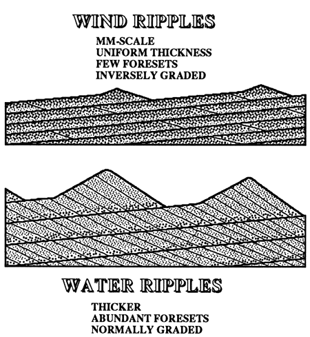
Based on stratification types (Hunter, 1977), quartzose grainstones are interpreted as eolianites. Coarsening-upward stratification is interpreted as subcritically climbing-translatent strata. Climbing-translatent stratification (Hunter, 1977, 1981; Kocurek and Dott, 1981) is considered diagnostic of eolian sedimentation. Each millimeter-scale, coarsening-upward stratum forms from the migration of a single, climbing wind ripple. Climbing wind ripples are distinct from climbing subaqueous ripples (fig. 16). The coarsest grains are concentrated along ripple crests while finer grains are protected in the ripple troughs (Hunter, 1977; Fryberger and Schenk, 1988). In the ripple troughs, very fine sand and very coarse silt are protected from incoming saltating grains and from direct airflow across the ripple crests (Fryberger and Schenk, 1988). Ripple-foreset laminae are not as well developed due to an absence of avalanching on the gently sloping lee sides of wind ripples. Distinctly coarsening-upward strata are absent in some climbing wind-ripple deposits due to coarser grain size (medium sand) or very low angles of ripple climb (Hunter, 1977).
Figure 16--Eolian versus subaqueous climbing ripples. Wind ripples have low amplitudes with the coarser grains concentrated at the ripple crest. Foresets are poorly developed; avalanching is thus rare. These features produce climbing-translatent strata that are characteristically thin, uniform thickness, commonly inversely graded, and contain few visible ripple-foreset laminae. In contrast, subaqueous ripples have higher amplitudes with the coarser grains relegated to the ripple troughs. Avalanching is common on the steep lee sides of the ripples. These features produce climbing-translatent strata that are thicker, normally graded, and contain well-developed ripple-foreset laminae (modified from Kocurek and Dott, 1981).
Climbing-translatent strata are as thick as 9 mm (fig. 12). The unusual thickness can be attributed to several possible mechanisms. Damp conditions would make the grains more cohesive, thus reducing the amount of the wind-ripple that is destroyed prior to its burial by the succeeding ripple train. According to Fryberger and Schenk (1981), increases in the rate of deposition and the rate of ripple-migration also can account for unusually thick climbing-translatent strata.
Indistinctly stratified intervals in quartzose grainstones are interpreted to have formed by grainfall in the flow separation on the lee side of dunes. Indistinct stratification is the result of excellent sorting of grains. Medium sand grains moving up the stoss side of the dunes by saltation and creep concentrate at the crest of the dune. These grains subsequently avalanche to form grainflows. Fine to very fine grains overrun the crest and are deposited on the lower slipface or apron as grainfall strata. Grainfall strata are distinguished from climbing-translatent strata because wind-ripple stratification exhibits a coarsening-upward grain distribution, ripple-foreset laminae, and generally have lower dips, although some overlap exists.
Collinson (1986) recognizes that some grainfall strata may be difficult to distinguish from climbing-translatent strata. Although climbing-translatent strata commonly coarsen upward, Fryberger and Schenk (198 1) report experimental data suggesting climbing-translatent strata may show no grading at all. Grainfall laminae may coarsen upward (Fryberger and Schenk, 198 1). In many of the quartzose grainstones, therefore, the origin of millimeter-scale alternating medium and very fine sand laminae is equivocal. Deposition by either climbing wind ripples or by grainfall under fluctuating wind regimes is possible. Only where ripple-foreset laminae are present can a wind-ripple origin be definite. The majority of alternating medium- and very fine-sand layers in the quartzose grainstone facies are very likely climbing-translatent strata based on recognition of ripple-foreset laminae in many of the coarsening-upward strata.
Fining-upward to structureless stratification is interpreted as grainflow strata. Coarser grains saltate and creep on the stoss side of the dune and become concentrated at the slipface crest. These grains subsequently avalanche, pick up finer grains by eroding underlying strata, and are later deposited as grainflows. Grainflow strata are extremely rare in the quartzose grainstone because either the upper parts of dunes were truncated by interdune erosion or avalanching on slipfaces was rare. Where present, grainflow deposits are intercalated with indistinctly stratified grainfall deposits or climbing-translatent strata, a common feature of small eolian dunes (Kocurek and Dott, 1981). While slipfaces in modern dunes are commonly 33-34°, grainflows in the Mobil #1 Foster never exceed 24°. Dip angles of approximately 20-24° are consistent with grainflow deposition at angle-of-repose deposition followed by approximately 35% compaction (cf. Rittenhouse, 1972) or by erosion of steeper upper puts of slipfaces (McKee, 1979). Basal contacts of grainflow deposits sometimes truncate underlying strata indicating scour of the underlying sediment. Thinning of as much as 4 mm across a 3.5-in (8.9-cm) core is observed, and is interpreted as wedging at the toe of a grainflow. The concave-upward nature of these units has been recognized at the toes of modern grainflows, indicating the preflow depositional surface (Hunter, 1977). Grainflow deposits are often reported as coarsening upward; coarser grains move upward owing to dispersive pressure during flow (Bagnold, 1954; Hunter, 1977; Kocurek and Dott, 198 1). Grain-size distribution, however, depends on the location in a grainflow. Coarsening- upward strata are more abundant in upper reaches of grainflows (Fryberger and Schenk, 1981; Ahlbrandt and Fryberger, 1982). The mantle of coarser grains outrun the finer grains to the lower part of the grainflow and are later buried by finer grained material, creating a fining-upward unit (Ahlbrandt and Fryberger, 1982).
The distribution of stratification types differs in the two eolian successions in the Mobil #1 Foster core. These successions illustrate two different styles of eolian sedimentation in these units over much of southwestern Kansas (figs. 14, 15, 17, and 18). Although they occur as separate intervals in the Foster core, these two styles of sedimentation are sometimes interstratified in the same eolian succession elsewhere in the Upper Mississippian of southwestern Kansas. The quartzose grainstone in the upper St. Louis is composed entirely of subcritically climbing-translatent strata with dips less than 7° (figs. 14 and 17). The numerous calcite-filled tubes coated by indistinctly laminated, dark-brown micrite near the top of the underlying shoaling-upward succession are interpreted as rhizoliths with calcite-filled root casts and dark-brown rhizocretions (cf. Klappa, 1980). The dark-brown color may indicate organic matter, probably incorporated under waterlogged, anaerobic conditions (cf. Goldstein, 1988). This indicates a hydromorphic calcrete paleosol. The thin micritic bridges associated with the rhizoliths are excellent examples of alveolar texture (cf. Esteban and Klappa, 1983). Tangential and random needle-fiber calcite cement are found in many calcretes (Esteban and Klappa, 1983). Upward-oriented, bladed, brownish, sparry-calcite cement is very similar to ribbon spar described from the Pennsylvanian Holder Formation in New Mexico (Goldstein, 1988). Goldstein reasoned that these cements precipitated in the capillary fringe at the base of the vadose zone. A similar origin for the brownish cements in the eolianites is likely, based on the preferred upward orientation and a few rounded termination surfaces of crystals.
Figure 17--Model for eolian sand sheets. Stratification is almost exclusively climbing-translatent with dips commonly less than 10°. rhizoliths are scattered throughout the unit and typically disrupt stratification. Sand sheets may comprise the entire eolian deposit or may be associated with cross-strata sets deposited by migrating dunes.
The base of each quartzose grainstone interval is marked by a lithoclast conglomerate (figs. 14, 15, and 17). Dark-brown lithoclasts are reworked from the underlying paleosol. These conglomerates were formed in part by deflation of the underlying skeletal limestones and calcretes. The Ste. Genevieve eolian unit is not underlain by a calcrete, yet the basal lag contains calcrete lithoclasts. Either the calcrete was removed by erosion or the calcrete clasts were transported from nearby. Wind deflation was not the sole mechanism, as such deposits should only be one grain thick (Bagnold, 1954). The thickest lag in the Mobil #1 Foster core is 0.65 ft (0.2 m) thick. Lithoclasts and well-rounded, syntaxial-cement overgrowths in the overlying climbing-translatent strata provide further evidence of the reworking of lithified limestones.
Figure 18--Model for active dune fields. Stratification is composed of abundant climbing-translatent strata, common grainfall, and rare grainflow units. Rhizoliths are rare to absent. Dips increase typically increase upward, reflecting preservation of dune aprons and lower slipfaces.
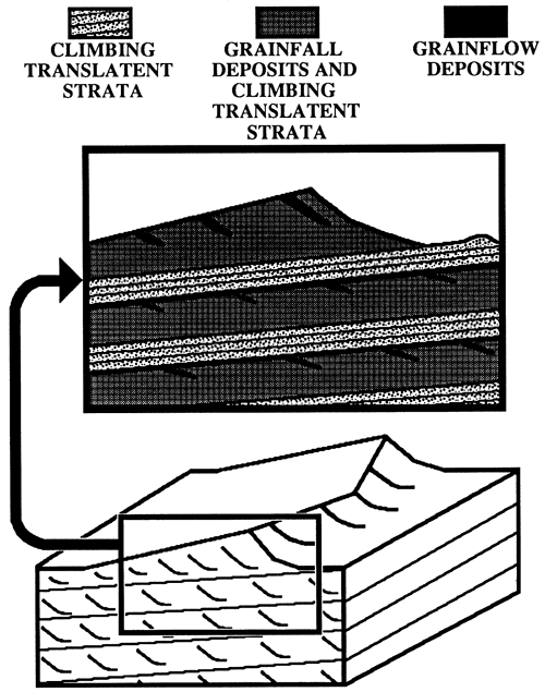
The abundance of climbing-translatent stratification and numerous rhizoliths indicates that the upper St. Louis eolianite was a vegetated sand sheet (figs. 14 and 17). Sand sheets are regions of predominantly eolian sedimentation where dunes with slipfaces are lacking (Kocurek, 1986; Kocurek and Nielson, 1986). Sand sheets commonly occur along the margins of dune fields (Kocurek, 1986). Conditions inhibiting the formation of dunes and favoring sand-sheet development include the following: 1) high water table, 2) surface cementation or binding, 3) periodic flooding, 4) significant coarse-grained sediment population, and 5) vegetation (Kocurek and Nielson, 1986). Many of these conditions appear to have been present during deposition of the St. Louis eolianite. The dark-brown color of paleosol features and capillary-fringe cements provides evidence for a high water table. Early cementation is indicated by calcrete and quartzose grainstone lithoclasts. Although coarse-grained sands are absent in wind-ripple deposits, the lithoclast deflation lag contains grains as large as 9 mm. Abundant rhizoliths indicate that the sand surface was partially stabilized by vegetation. Another factor contributing to development of a sand sheet is time. Thousands to tens of thousands of years are required to build a dune several hundred feet high (Ahlbrandt and Fryberger, 1982). The thinness (3.8 ft or 1.2 m) of the St. Louis eolianite is consistent with the idea that eolian sedimentation was short-lived, and dunes may not have had time to develop. Although it is difficult to isolate the contribution of each variable to the formation of the St. Louis sand sheet, the abundance of rhizoliths suggests vegetation may have been the most important factor.
In contrast to the St. Louis sand sheet, the Ste. Genevieve eolianite lacks rhizoliths and consists of higher-angle cross stratification in sets up to 1.5 ft (0.5 m) thick (figs. 15 and 18). This indicates the presence of an unvegetated, active dune field. Interdune deposits are not recognized. The majority of cross-strata dip less than 20°, suggesting only dune aprons are commonly preserved. Only in the thicker cross-strata sets are slipfaces and the toes of grainflows preserved. Thickness of eolian grainflows are proportional to slipface height. Based on a plot of maximum eolian grainflow thickness versus slipface height (Kocurek and Dott, 1981), the thickest grainflow in the Ste. Genevieve eolianites of 1.6 cm corresponds to a slipface 0.9 m high. This is consistent with maximum thickness of cross-strata in the Mobil #1 Foster core. Additionally, thicknesses of cross strata in other Ste. Genevieve cores in southwestern Kansas rarely exceed this estimate of slipface height.
Formation boundaries
In order to facilitate consistent identification of Upper Mississippian lithostratigraphic boundaries, criteria for such picks need to be standardized. Facies changes make the identification of Upper Mississippian units difficult. Facies changes are hard to recognize unless core or cuttings are utilized. In this report, 13 cores covering much of the southern Hugoton embayment are used to calibrate log response to facies. The following section discusses lithostratigraphic boundaries for the following units: 1) Salem Limestone, 2) lower St. Louis Limestone, 3) upper St. Louis Limestone, 4) Ste. Genevieve Limestone, and 5) Shore Airport Formation (fig. 1).
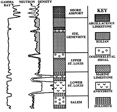
Salem strata in southwestern Kansas consist of cyclic shoaling-upward marine limestones. Lithologically it shares many similarities to the Salem in the western part of the Illinois basin (cf. Cluff, 1984). The upper part of the Salem in the Hugoton embayment is commonly a high-energy oolitic or skeletal grainstone that typically has excellent intergranular porosity. Salem carbonates are commonly partially to completely dolomitized. Some cores contain nodular chert. Recognition of the Salem in wireline logs is often difficult because it is bounded by carbonate formations. The uppermost Salem is recognized on gamma ray-porosity logs as a clean, porous, slightly dolomitic grainstone, representing the uppermost shoal facies (fig. 19). This shoal facies is not extensively dolomitized because dolomite preferentially replaces micrite.
Figure 19--Hypthetical gamma ray-neutron density log for Upper Mississippian strata.
The St. Louis Limestone is divided into two informal members. In the Illinois basin, lithologically similar informal members have been recognized (Jorgenson and Carr, 1973). In the eastern and northern parts of the Hugoton embayment, typical lithologies of the lower St. Louis are poorly developed to absent and member designation is difficult.
In the Mobil #1 Foster, lower St. Louis strata consist primarily of three facies: 1) peloid grainstone/packstone, 2) dolomite, and 3) anhydrite. In core, the Salem-lower St. Louis boundary is marked by a change from shallow-marine carbonates below to restricted lagoonal facies of the lower St. Louis. On wireline logs, the exact placement of the boundary is difficult as both units are typically dolomitic. Often it is possible to recognize a change from clean, porous dolomitic limestone of the upper Salem to slightly more argillaceous, dolomitic carbonate intercalated with anhydrite (fig. 19).
Upper St. Louis strata are composed primarily of skeletal packstone and wackestone. Several shoaling-upward cycles are present, capped by thin oolitic and skeletal grainstone and packstone. Relative to much of the upper St. Louis, cycles in the uppermost St. Louis typically contain thicker oolitic grainstone caps. A thin eolian unit in the upper St. Louis is laterally traceable over much of southwestern Kansas and is commonly bounded by porous oolitic grainstones. In many areas, this thin eolian unit is very close to the St. Louis-Ste. Genevieve boundary. It is placed in the St. Louis, however, because it is very thin and is not easily recognizable on logs. On gamma-ray logs, the upper St. Louis is a relatively clean limestone. Neutron-density log traces closely overlay each other (fig. 19). The lower and upper St. Louis boundary is commonly placed at the change from dolomitized restricted lagoon carbonate and evaporite to marine limestone (fig. 19).
Intercalated eolian quartzose grainstone and subtidal strata define the Ste. Genevieve Limestone. Traditionally, oolitic limestone in southwestern Kansas has been placed in the St. Louis Limestone (e.g. Clair, 1948, 1949; Thompson and Goebel, 1963, 1968). In the Illinois basin, however, the base of the Ste. Genevieve is generally placed at the stratigraphically lowest prominent oolitic limestone (Atherton et al., 1975). In order to be consistent with the original definition in the type area, a similar boundary could be adopted in the Hugoton embayment. However, several considerations argue against such a boundary.
The boundary could be picked at the base of the stratigraphically lowest prominent oolite, but this pick is difficult without core or cuttings. Although many of the ooid grainstones are porous, intergranular porosity is occluded in many others by a combination of compaction and cementation, as in the Mobil # 1 Foster. In wells without porous carbonates, this formation boundary would not be easily determined using wireline logs alone. Additionally, previous definitions including oolites in the upper St. Louis are well entrenched in the literature and in industry, and it is best not to change unless a more practical boundary can be determined.
The base of the Ste. Genevieve is placed at the stratigraphically lowest prominent quartzose grainstone. Typically, the quartzose Ste. Genevieve is easily separated from the qquartz-poor upper St. Louis by a separation of the neutron and density log patterns, both calibrated for limestone (fig. 19). Minor detrital quartz occurs in many interbedded subtidal strata; some contain a significant quartz component. The presence of quartz in obviously subtidal strata, combined with the absence of significant quartz in some Ste. Genevieve sections, make tracing of individual eolian quartzose grainstones extremely difficult. In cases where quartzose facies are absent or poorly developed, the Ste. Genevieve-upper St. Louis boundary can usually be placed at the base of a small gamma-ray peak that immediately overlies the uppermost porous, presumably oolitic, limestone.
The overlying Shore Airport Formation (Abegg, in prep. (a)) consists primarily of argillaceous peloidal packstone and thin interbedded calcareous shales. Many of these shale beds are paleosol horizons, with clay concentrated by illuviation in the B soil horizon. Shales are typically variegated red, green, and purple and contain rhizoliths (Abegg, in prep. (a)). Locally, the Shore Airport includes a basal sandstone and conglomerate (Clair, 1948, 1949; Veroda, 1959; Fugitt and Wilkinson, 1959). Fossiliferous marine oolite (Clair, 1948, 1949) and argillaceous, fossiliferous marine limestone are also found in the Shore Airport. The boundary between the Shore Airport and Ste. Genevieve is one of the most consistent picks in the Mississippian section because of the increased argillaceous component to the Shore Airport. This boundary should be placed where the neutron curve shifts from right of the density curve (matrix calibrated for limestone) in the quartzose Ste. Genevieve to left of the density curve in the argillaceous carbonates of the Shore Airport (fig. 19). This boundary so defined typically corresponds to the base of a shale observable on the gamma-ray log.
The contact of the Shore Airport Formation and the overlying Kearny Formation (Morrowan) is commonly a difficult log pick. Recognition of this boundary is further complicated by the high-relief unconformity that separates Mississippian and Pennsylvanian strata. The Kearny typically contains significantly more shale and sandstone dm the underlying Shore Airport. In the southeastern Hugoton embayment, the Shore Airport is directly overlain by carbonates and thin shales of the Atokan. Atokan carbonates are commonly less argillaceous and the shales more radioactive than limestones and shales of the underlying Shore Airport. In cases where the Shore Airport has been eroded (fig. 2), the Ste. Genevieve or the St. Louis are directly overlain by Morrowan or Atokan strata. The increased siliciclastic component of Pennsylvanian strata makes this a consistently easy pick.
Lateral variability
The St. Louis and Ste. Genevieve Limestones contain similar successions of lithologies over much of the Hugoton embayment. Core and log analyses permit characterization of lateral facies and compositional variability. Details of lateral variability are still being investigated.
Lower St. Louis strata are best developed in the southwestern part of the Hugoton embayment in southwestern Kansas. To the north and east, however, recognition of characteristic anhydrite and shaly dolomitic carbonate on wireline logs is difficult. Lower St. Louis strata are not easily recognized east of Seward and Haskell counties and north of southernmost Hamilton and Kearny counties. The absence of anhydrite from the northern and eastern parts of the Hugoton embayment could be due to a lateral change to deposition under less-restricted conditions or to the dissolution of evaporites during shallow burial.
Solution-collapse breccias, formed by the dissolution of anhydrite beds and concomitant collapse of intercalated and immediately overlying strata, are abundant in many lower St. Louis cores in southwestern Kansas (Abegg, in prep. (b)). This indicates the evaporites had a much wider areal extent than previously reported, extending at least as far north as southern Logan County. Cored solution-collapse breccias commonly consist of porous dolomites that have similar neutron-density log traces to the underlying Salem. They can be differentiated using the gamma-ray log; upper Salem high-energy grainstones are typically clean, whereas lower St. Louis low-energy restricted carbonates are typically somewhat shaly.
Upper St. Louis strata are similar over much of southwestern Kansas. The majority of upper St. Louis consists of normal-marine skeletal packstone and wackestone. Thickest ooid grainstone occurs near the top of the St. Louis Limestone. A thin eolian unit is interstratified with oolitic grainstone and packstone in the upper St. Louis. This unit is very close to the base of the Ste. Genevieve in most cores, but in Stevens County it is separated by a thicker section of subtidal strata. This probably results from increased subsidence in the southern part of the Hugoton embayment.
Eolian quartzose grainstones are punctuated by several subtidal intervals in the Ste. Genevieve Limestone. Up to three (perhaps four) quartzose grainstone units are recognized in core, and as many as five quartzose grainstone intervals are recognized,using a combination of core and wireline logs. The lowermost eolianite is typically thin and not easily recognized on logs. In some wells, quartzose grainstone is either poorly developed or absent. This suggests that eolian units are not laterally continuous or that quartz content is variable. Another problem in regional correlation of eolian strata is that some cores contain subtidal strata with a significant quartz fraction. This emphasizes the need for core to facilitate correlation of eolian strata. No consistent regional trends in quartz concentration have yet been recognized.
Correlation of quartzose grainstones is currently being evaluated. Lateral extent of these intervals is important in determination of the setting of eolian deposition. Laterally correlative eolianites suggest regional sand seas (ergs). Lenticular eolianites suggest coastal dune complexes.
Biostratigraphy
Conodont biostratigraphy commonly has been used in conjunction with lithostratigraphic studies of Mississippian strata in Kansas (e.g. Thompson and Goebel, 1963, 1968). Definition of lithostratigraphic boundaries should be independent of conodont zones. Formations are rock-stratigraphic units defined by lithofacies. Conodont data, however, are useful in several ways. Comparison of conodont fauna from a lithofacies on different parts of the shelf can indicate diachroneity. In this case biostratigraphy may lack sufficient resolution. Conodont data are useful in comparison of lithofacies from different basins, for example to test whether St. Louis and Ste. Genevieve strata are roughly coeval in the Hugoton embayment and the Illinois basin. Thompson and Goebel (1968, p. 19) report that St. Louis and Ste. Genevieve strata in Kansas are "synchronous with the equivalent formations in the Mississippi River Valley" region.
The control of environmental factors on conodont distribution is a concern in biostratigaphy. This concern is minimized *in correlating between similar depositional settings. Coincidence of Mississippian biostratigraphic and lithostratigraphic boundaries in Kansas (Thompson and Goebel, 1968) suggests that facies dependency is a strong possibility.
Mobil #1 Foster conodont samples from the St. Louis and Salem are consistent with the St. Louis fauna for southwestern Kansas as described by Thompson and Goebel (1968) (table 4). Above the upper St. Louis eolianite, samples of Cavusgnathus unicornis are consistent with either a St. Louis or Ste. Genevieve fauna. No conodonts were recovered from the Ste. Genevieve because most samples were taken from restricted facies that are generally barren of fossils. Conodonts from the Mobil #1 Foster indicate these formations are roughly synchronous with equivalent formations in the Illinois basin.
Table 4--Conodonts remvered from the Mobil #1 Foster (sec. 5, T. 34 S., R. 36 W.) in Stevens County, Kansas. Conodont identification by Richard Lane of Amoco. Lithostratigraphic boundaries determined by facies, independently of biostratigraphy.
| Interval (ft) |
Identification | Number of specimens |
|---|---|---|
| 6909-6910.0 | Cavusgnathus altus | 1 |
| Taphrognathus 23360 | 3 | |
| Spathognathodus eoscitulus | 1 | |
| Indeterminant conodonts | 17 | |
| 6906-6907 | Apatognathus n. sp. A. | 5 |
| Cavusgnathus altus | 1 | |
| Taphrognathus 23360 | 2 | |
| Taphrognathus varians | 2 | |
| Spathognathodus penescitulus | 1 | |
| Spathognathodus eoscitulus | 1 | |
| Indeterminant conodonts | 21 | |
| 6902-6903 | Taphrognathus 23360 | 5 |
| Cavusgnathus unicornis | 2 | |
| Apatognathus n. sp. a | 2 | |
| Spathognathodus penescitulus | 1 | |
| Indeterminant conodonts | 12 | |
| 6888-6889 | Taphrognathus 23360 | 1 |
| Apatognathus n. sp. a | 1 | |
| Indeterminant conodonts | 10 | |
| Lithostratigraphic top of Salem (6879) | ||
| 6878 | Indeterminant conodonts | 2 |
| 6825 | Indeterminant conodonts | 3 |
| 6815 | Apatognathus geminus | 3 |
| Apathognathus porcatus | 1 | |
| Cavusgnathus unicornis | 1 | |
| Taphrognathus 23360 | 2 | |
| Spathognathodus penescitulus | 1 | |
| Indeterminant conodonts | 26 | |
| 6811.5-6812.5 | Barren of conodonts | |
| 6806.5-6807.5 | Taphrognathus 23360 | 1 |
| Indeterminant conodonts | 7 | |
| Lithostratigraphic top of the lower St. Louis (6804) | ||
| 6803-6804 | Apatognathus geminus | 3 |
| Cavusgnathus unicornis | 4 | |
| Cavusgnathus altus | 3 | |
| Spathognathodus scitulus | 4 | |
| Spathognathodus cristulus | 2 | |
| Indeterminant conodonts | 14 | |
| 6790-6791 | Spathognathodus scitulus | 4 |
| Apatognathus geminus | 4 | |
| Apathognathus porcatus | 1 | |
| Indeterminant conodonts | 11 | |
| 6783-6784.5 | Spathognathodus penescitulus | 1 |
| Taphrognathus 23360 | 1 | |
| Cavusgnathus sp. | 1 | |
| Indeterminant conodonts | 5 | |
| 6772 | Indeterminant conodonts | 5 |
| 6761-6762.5 | Barren of conodonts | |
| 6752.5-6753.5 | Spathognathodus penescitulus | 2 |
| Indeterminant conodonts | 7 | |
| 6743.5-6744.5 | Barren of conodonts | |
| 6740-6741 | Cavusgnathus altus | 1 |
| Cavusgnathus sp. | 1 | |
| Spathognathodus cristulus | 2 | |
| Indeterminant conodonts | 18 | |
| 6737.0 | Barren of conodonts | |
| 6732-6733 | Magnilateralla robusta | 1 |
| 6729.0-6730 | Ligonodina levis | 1 |
| 6722.5-6723.5 | Spathognathodus scitulus | 1 |
| Gnathodus commutatus commutatus | 1 | |
| Cavusgnathus altus | 1 | |
| Magnilateralla robusta | 2 | |
| Apathognathus porcatus | 1 | |
| Indeterminant conodonts | 19 | |
| 6713-6714 | Cavusgnathus altus | 2 |
| Indeterminant conodonts | 6 | |
| 6710-6711 | Cavusgnathus unicornis | 1 |
| Indeterminant conodonts | 10 | |
| 6699-6700 | Cavusgnathus unicornis | 1 |
| Indeterminant conodonts | 3 | |
| 6690 | Barren of conodonts | |
| 6686.0 | Barren of conodonts | |
| 6662.5-6663.5 | Cavusgnathus unicornis | 1 |
| Cavusgnathus offset | 1 | |
| Indeterminant conodonts | 4 | |
| 6661-6662 | Cavusgnathus unicornis | 2 |
| Cavusgnathus sp. | 2 | |
| Neopriontiodus sp. | 1 | |
| Ligonodina sp. | 2 | |
| Indeterminant conodonts | 18 | |
| Lithostratigraphic top of the upper St. Louis (6660) | ||
| 6649-6650 | Barren of conodonts | |
| 6643 | Barren of conodonts | |
| 6640-6641 | Barren of conodonts | |
| 6632-6633 | Barren of conodonts | |
Sedimentology
Upper Salem strata consist of marine shoaling-upward cycles. The top of the Salem in many cores is a relatively thick, porous, oolitic, and skeletal grainstone. Deposition of dolomitic carbonate and anhydrite of the lower St. Louis record the onset of restricted conditions. Salem high-energy shoals are interpreted to have prograded basinward (roughly southward), restricting circulation on the shelf (fig. 7).
A relative rise in sea level at the base of the upper St. Louis is indicated by a thin oolitic and skeletal grainstone overlain by skeletal packstone and wackestone with minor shoaling-upward cycles. The upper part of the St. Louis is composed of shoaling-upward carbonates with thicker oolitic and skeletal grainstone caps. A thin eolian unit near the middle of the upper St. Louis is typically underlain by a calcrete paleosol indicating subaerial exposure.
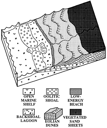
The Ste. Genevieve contains several eolian quartzose grainstone intervals. The lower boundary of the Ste. Genevieve is a subaerial exposure surface, commonly marked by a calcrete or a lithoclast deflation lag with reworked calcrete clasts. The remainder of the Ste. Genevieve consists of eolian quartzose grainstone intercalated with subtidal strata. Because most Ste. Genevieve cores are incomplete and wireline logs indicate that quartz-rich facies are poorly developed to absent in some wells, recognition and correlation of eolian units is difficult. Fig. 20 shows the lateral relationships of upper St. Louis and Ste. Genevieve depositional environments.
Figure 20--Block diagram showing the lateral distribution of facies that deposited upper St. Louis and Ste. Genevieve strata. Angle of dune climb is exaggerated for illustrative purposes. The shoreline is interpreted to be a low-energy beach, with energy being dissipated on oolitic shoals. Beach strata have not been observed due to subsequent deflation or lack of recognition.
The base of the Shore Airport Formation is typically marked by a variegated red calcareous shale with rhizoliths (Abegg, in prep (a)). Based on limited core data, this type of paleosol recurs between successive argillaceous peloidal packstones. Due to an absence of core data, the lateral extent of these paleosols is uncertain. In Meade and Seward counties, the base of the Shore Airport is marked by a porous sandstone, limestone conglomerate, and coaly shale. The limestone lithoclasts are composed of dark-brown calcrete and eolian quartzose grainstone reworked from the underlying Ste. Genevieve. Well-preserved fenestrate bryozoan fronds in overlying strata indicate marine conditions. More work is needed to fully understand deposition of the Shore Airport.
The Mississippian-Pennsylvanian boundary in southwestern Kansas is a disconformity involving extensive erosion. In extreme southwestern Seward County, the thickness of the Shore Airport changes by as much as 247 ft (75 in) between two wells approximately 7 mi (11 km) apart. A structural cross section indicates this thickening of the Shore Airport is caused by erosion over a structural high. Reworked Mississippian lithoclasts at the base of the Pennsylvanian occur in a transgressive lag formed as the seas flooded the previously subaerially exposed shelf.
Sequence stratigraphy
Recognition of paleosols and eolianites is important in a sequence-stratigraphic interpretation of Upper Mississippian strata. These features indicate subaerial exposure and are excellent indicators of sequence boundaries (cf. Van Wagoner et al., 1988). Division of the St. Louis and Ste. Genevieve into sequences is useful in hydrocarbon exploration to help predict the distribution chronostratigraphic relationships of facies. The sequence-stratigraphic model proposed for the Upper Mississippian (fig. 21) is not a finished product, but a current interpretation based on widely spaced cores and regional log cross sections that are still being refined.
Figure 21--Sequence stratigraphy of Upper Mississippian strata in the Hugoton embayment of southwestern Kansas. This cross section is oriented roughly north-south. Lateral continuity of eolian strata is still being investigated. SB--sequence boundary, TS--transgressive surface. Wavy line at the top of the Mississippian separates the Kaskaskia sequence from the overlying Absaroka sequence (Sloss, 1963).
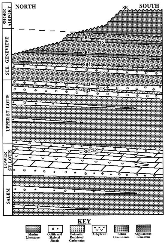
The top of the lower St. Louis evaporite is interpreted as a sequence boundary (SB1). This is a type-2 sequence boundary whose exact location is difficult to define because the strata are relatively conformable on this part of the shelf. This sequence boundary is inferred to be an unconformity to the north as units pinch out toward the Transcontinental arch. The top of the evaporite approximates the maximum regression in the succession. Evaporite deposition probably ended when marine waters began to inundate the shelf. Additionally, this surface probably corresponds to a shift from progradational or aggradational strata to retrogradational strata.
The lower-upper St. Louis boundary represents a transgressive surface (TS). Basal upper St. Louis skeletal and oolitic grainstone are a thin unit deposited as marine waters flooded the shelf. The top portion of the upper St. Louis contains shoaling-upward cycles or parasequences. These parasequences are capped by progressively thicker skeletal and oolitic grainstones, suggesting a progradational or aggradational parasequence set. Subaerial exposure at the base of the thin eolian unit in the upper St. Louis marks the second sequence boundary (SB2). The top of the eolian unit is another transgressive surface and is commonly overlain by two or more parasequences composed of predominantly oolitic grainstones.
The base of the Ste. Genevieve is marked by a subaerial exposure surface and is the third sequence boundary (SB3). The remainder of the Ste. Genevieve is marked by several sequence boundaries (SB4-6) separating eolian and subtidal strata. Sequence boundaries 3 and 4 have been recognized in core; sequence boundaries 5 and 6 are tentatively inferred from log correlations. The interbedded eolian and subtidal sequences are thinner than the sequence in the underlying St. Louis. If traced basinward, however, the Ste. Genevieve sequences would most likely thicken and show more marine influence due to increased subsidence and accommodation space in the outer shelf. Sequences there might be more similar to the underlying St. Louis sequence.
Shore Airport strata contain numerous paleosols within a succession of argillaceous peloid packstone (Abegg, in prep. (a)). The Amoco #1 Breeding F contains at least seven closely spaced but separate paleosols. These numerous paleosols (sequence boundaries?) are consistent with marked cyclicity in Chesterian strata over much of North America. More work is needed to understand the sequence stratigraphy of the Shore Airport Formation.
The top of the Shore Airport is marked by a subaerial exposure surface that separates the Mississippian and Pennsylvanian systems over much of North America. This surface also corresponds to the first-order sequence boundary between the Kaskaskia and Absaroka sequences of Sloss (1963). In extreme southwestern Seward County, erosion over a structural high changes the thickness of the Shore Airport by as much as 247 ft (75 m) between two wells approximately 7 mi (11 km) apart. In the northern and eastern puts of the Hugoton embayment in southwestern Kansas, the sub-Pennsylvanian unconformity truncates increasing older strata (fig. 1).
Sequence boundaries 2 and 3 (SB2 and SB3) occur interstratified with oolitic grainstones that are often excellent reservoir beds and are overlain by eolianites. Correlation of these sequence boundaries within reservoirs provides an excellent tool to map porous ooid grainstones and to evaluate lateral reservoir heterogeneity. Conversely, the eolianites are tight and may form vertical barriers to fluid migration within a reservoir. Such factors should prove to be invaluable in secondary-recovery projects.
Conclusions
- Mobil #1 Foster contains six lithofacies representative of the St. Louis and Ste. Genevieve Limestones across much of the Hugoton embayment: 1) peloid grainstone/packstone, 2) anhydrite, 3) dolomite, 4) skeletal packstone/wackestone, 5) oolitic grainstone/packstone, and 6) quartzose grainstone.
- Abundant peloids, evaporites, and paucity of stenohaline marine organisms in the lower St. Louis indicate that the peloid grainstone/packstone, anhydrite, and dolomite facies were deposited in a restricted lagoon. Subadjacent oolitic facies in the uppermost Salem suggests that shoals created barriers to circulation in a backshoal lagoonal environment.
- Periodic winnowing, intercalated oolites, and a diverse and abundant assemblage of echinoderms, brachiopods, and bryozoans indicate upper St. Louis skeletal packstone/wackestone was deposited in a normal-marine shelf environment at or near normal wavebase. Upper St. Louis oolitic grainstone/packstone, the reservoir facies, accumulated in a highly agitated, marine-shoal environment, probably at depths less than 5 m.
- A quartzose grainstone 3.8 ft (1.2 m) thick in the upper St. Louis contains abundant rhizoliths and ubiquitous climbing-translatent strata, indicating deposition by a vegetated eolian sand sheet.
- A quartzose grainstone 9.4 ft (2.9 m) thick in the basal Ste. Genevieve lacks rhizoliths and consists of abundant climbing-translatent, common grainfall, and minor grainflow stratification in crossbed sets up to 1.5 ft (0.5 m) thick with dips as high as 240. This crossbedding and the apparent absence of vegetation indicate deposition by eolian dunes.
- The base of the St. Louis is marked by a shift from shoaling-upward, shallow-marine carbonate of the Salem to restricted, peloid grainstone/packstone, dolomite, and anhydrite of the lower St. Louis. A marine transgression resulted in renewed deposition of shallow-marine limestone in the upper St. Louis. Progressively thicker oolitic intervals cap shoaling-upward cycles in the uppermost St. Louis, suggesting progradation or aggradation of high-energy shoals. Ste. Genevieve eolian quartzose grainstone is intercalated with subtidal carbonate. The overlying Shore Airport Formation consists of argillaceous peloidal packstone punctuated by numerous shaly paleosols.
Acknowledgments
This study is part of a dissertation at the University of Kansas under the direction of Paul Enos. I would like to thank Paul for his guidance and input. His editorial comments and suggestions significantly improved this report. Editorial comments and suggestions of Lynn Watney, Tony Walton, and Craig Caldwell are also greatly appreciated. This research has been supported by the Geology Associates Program of the University of Kansas Endowment Association, the Kansas Geological Survey, Amoco Production Company, and Phillips Petroleum Company. I would like to thank Amoco Production Company and the Kansas Geological Survey for providing access to numerous Upper Mississippian cores. Special thanks are extended to Amoco's Van Leighton for his assistance and consideration. Amoco's Richard Lane graciously provided conodont identifications. Kevin Evans, John Youle, and Chris Maples contributed to discussions that improved ideas used in this report. Michelle Abegg assisted in some of the word processing and computer drafting for this report.
References
Abegg, F. E., in prep. (a), Lithostratigraphy of the Shore Airport Formation (Chesterian, new name), southwestern Kansas: Kansas Geological Survey, Bulletin 230
Abegg, F. E.,, in prep. (b), Sedimentology and lithostratigraphy of the Ste. Genevieve and St. Louis Limestones (Upper Mississippian), southwestern Kansas: Ph.D. dissertation, University of Kansas, Lawrence, KansasAbegg, F. E., in prep. (c), Reference section for the Ste. Genevieve and St. Louis Limestones (Upper Mississippian), southwestern Kansas: Kansas Geological Survey, Bulletin 230
Ahlbrandt, T. S., and Fryberger, S. G., 1982, Introduction to eolian deposits; in, Sandstone Depositional Environments, P. A. Scholle and D. Spearing, eds.: American Assoc. of Petroleum Geologists, Memoir 31, p. 11-47
Atherton, E., Collinson, C., and Lineback, J. A., 1975, Mississippian System; in, Handbook of Illinois Stratigraphy, H. B. Willman et al., eds.: Illinois State Geological Survey, Bulletin 95, p. 123-163
Bagnold, R. A., 1954, The physics of blown sand and desert dunes: London, Methuen
Beebe, B. W., 1959a, Characteristics of Mississippian production in the northwestern Anadarko basin: Tulsa Geological Society, Digest, v. 27, p. 190-205
Beebe, B. W., 1959b, Characteristics of Mississippian production in the northwestern Anadarko basin; in, Proceedings of the Sixth Biennial Geological Symposium, C. A. Moore, ed.: Norman, Oklahoma, University of Oklahoma, p. 176-196
Blatt, H., Middleton, G., and Murray, R., 1980, Origin of sedimentary rocks: Prentice-Hall, Englewood Cliffs, New Jersey, 782 p.
Cecil, C. B., 1990, Paleoclimate controls on stratigraphic repetition of chemical and siliciclastic rocks: Geology, v. 18,p. 533-536
Choquette, P. W., and Pray, L. C., 1970, Geologic nomenclature and classification of porosity in sedimentary carbonates: American Assoc. of Petroleum Geologists, Bulletin, v. 54, p. 207-250
Clair, J. R., 1948, Preliminary notes on lithologic criteria for identification and subdivision of the Mississippian rocks in western Kansas: Kansas Geological Society, 14 p.
Clair, J. R., 1949, Lithologic criteria of Mississippian rocks in western Kansas: World Oil, p. 61-66
Clark, E. L., 1937, The St. Louis Formation of southwestern Missouri: Missouri Geological Survey and Water Resources, Biennial Report of State Geologist to the 59th General Assembly, Appendix 4, 13 p.
Cluff, R. M., 1984, Carbonate sand shoals in the Middle Mississippian (Valmeyeran) Salem-St. Louis-Ste. Genevieve Limestones, Illinois basin; in, Carbonate Sands--A Core Workshop, P. M. Harris, ed.: Soc. of Economic Paleontologists and Mineralogists, Core Workshop No. 5, p. 94-135
Collinson, J. D., 1986, Deserts; in, Sedimentary Environments and Facies, H. G. Reading, ed.: Blackwell, Oxford, p. 95-112
Dean W. E., Davies, G. R., and Anderson, R. Y., 1975, Sedimentological significance of nodular and laminated anhydrite: Geology, v. 3, p. 367-372
Dravis, J., 1979, Rapid and widespread generation of recent oolitic hardgrounds on a high-energy Bahamian platform, Eleuthera bank, Bahamas: Journal of Sedimentary Petrology, v. 49, p. 195-208
Dunham, R. J., 1962, Classification of carbonate rocks according to depositional texture; in, Classification of Carbonate Rocks--A Symposium, W. E. Ham, ed.: American Assoc. of Petroleum Geologists, Memoir 1, p. 108-121
Esteban, M., and Klappa, C. F., 1983, Subaerial exposure environment; in, Carbonate Depositional Environments, P. A. Scholle, ed.: American Assoc. of Petroleum Geologists, Memoir 33, p. 1-54
Folk, R. L., and Pittman, J. S., 1971, Length-slow chalcedony--a new testament for vanished evaporites: Journal of Sedimentary Petrology, v. 41, p. 1,045-1,058
Fryberger, S. G., and Schenk, C. J., 1981, Wind sedimentation tunnel experiments on the origins of aeolian strata: Sedimentology, v. 28, p. 805-821
Fryberger, S. G., and Schenk, C. J., 1988, Pin stripe lamination--a distinctive feature of modern eolian and ancient sediments: Sedimentary Geology, v. 55, p. 115
Fugitt, L. B., and Wilkinson, R. D., 1959, Eubank field; in, Kansas Oil and Gas Fields, vol. II, Western Kansas: Kansas Geological Society, p. 13-20
Gebelein, C. D., 1969, Distribution, morphology, and accretion rate of Recent subtidal algal stromatolites: Journal of Sedimentary Petrology, v. 39, p. 49-69
Girty, G. H., 1940, Report on fossils of Mississippian age from well cores in western Kansas; in, Subsurface Mississippian Rocks of Kansas, W. Lee, ed.: Kansas Geological Survey, Bulletin 33, p. 97-114
Goebel, E. D., 1968, Mississippian rocks of western Kansas: American Assoc. of Petroleum Geologists, Bulletin, v. 52, p. 1,732-1,778
Goldstein, R. H., 1988, Paleosols of Late Pennsylvanian cyclic strata, New Mexico: Sedimentology, v. 35, p. 777-803
Handford, C. R., 1988, Review of carbonate sand-belt deposition of ooid grainstones and application to Mississippian reservoir, Damme field, southwestern Kansas: American Assoc. of Petroleum Geologists, Bulletin v. 72, p. 1,184-1,199
Handford, C. R., 1990, Mississippian carbonate eolianites in southwestern Kansas (abs.): American Assoc. of Petroleum Geologists, Bulletin, v. 74, p. 669
Handford, C. R., and Francka, B. J., 1991, Mississippian carbonate-siliciclastic eolianites in southwestern Kansas; in, Mixed Carbonate-Siliciclastic Sequences, A. J. Lomando and P. M. Harris, eds.: Soc. of Economic Paleontologist and Mineralogists, Core Workshop No. 15, p. 205-243
Hunter, R. E., 1977, Basic types of stratification in small eolian dunes: Sedimentology, v. 24, p. 361-387
Hunter, R. E., 1981, Stratification styles in eolian sandstones--some Pennsylvanian to Jurassic examples from the Western Interior U.S.A.; in, Recent and Ancient Nonmarine Depositional Environments--Models for Exploration, F. G. Ethridge and R. M. Flores, eds.: Soc. of Economic Paleontologist and Mineralogists, Special Publication 31, p. 315-329
Hunter, R. E., 1989, Eolianites in the Ste. Genevieve Limestone of southern Indiana: American Assoc. of Petroleum Geologists, Eastern Section Meeting Guidebook, 19 p.
Jorgensen, D., and Carr, D. D., 1973, Influence of cyclic deposition, structural features, and hydrologic controls on evaporite deposits in the St. Louis Limestone in southwestern Indiana; in, Proceedings, Eighth Forum on Geology of Industrial Minerals: Iowa Geological Survey, Public Information Circular 5, p. 43-65
Kerr, S. D., and Thomson, A., 1963, Origin of nodular and bedded anhydrite in Permian shelf sediments, Texas and New Mexico: American Assoc. of Petroleum Geologists, Bulletin, v. 47, p. 19726-19732
Klappa, C. F., 1980, Rhizoliths in terrestrial carbonates; classification, recognition, genesis, and significance: Sedimentology, v. 27, p. 613-629
Kocurek, G., 1986, Origins of low-angle stratification in aeolian deposits; in, Aeolian Geomorphology, W. G. Nickling, ed.: Allen & Unwin, Boston, p. 177-193
Kocurek, G., and Dott, R. H., 1981, Distinctions and uses of stratification types in the interpretation of eolian sand: Journal of Sedimentary Petrology, v. 51, p. 579-596
Kocurek, G., and Nielson, J., 1986, Conditions favourable for the formation of warm-climate aeolian sand sheets: Sedimentology, v. 33, p. 795-816
Lane, H. R., and DeKeyser, T. L., 1980, Paleogeography of the late Early Mississippian (Tournaisian 3) in the central and southwestern United States; in, Paleozoic Paleogeography of the West-central United States, T. D. Fouch and E. R. Magathan, eds.: Rocky Mountain Society of Economic Paleontologist and Mineralogists, p. 149-162
Lee, W., 1940, Subsurface Mississippian rocks of Kansas: Kansas Geological Survey, Bulletin 33, 114 p.
Loucks, R. G., and Longman, M. W., 1982, Lower Cretaceous Ferry Lake Anhydrite, Fairway field, east Texas--product of shallow-subtidal deposition; in, Depositional and Diagenetic Spectra of Evaporites--A Core Workshop, C. R. Handford, R. G. Loucks, and G. R. Davies, eds.: Soc. of Economic Paleontologist and Mineralogists, Core Workshop No. 3, p. 130-173
Maiklem, W. R., Bebout, D. G., and Glaister, R. P., 1969, Classification of anhydrite--a practical approach: Canadian Petroleum Geologists Bulletin, v. 17, p. 194-233
Maples, C. G., and Waters, J. A., 1987, Redefinition of the Meramecian/Chesterian boundary (Mississippian): Geology, v. 15, p. 647-651
Martorana, A., 1987, Lithology and depositional environment of the St. Louis Limestone; in, Geology and Petroleum Production of the Illinois Basin, C. W. Zupann and B. D. Keith, eds.: Illinois Geological Soc., v. 2, p. 125
McKee, E. D., 1979, Ancient sandstones considered to be eolian; in, A Study of Global Sand Seas, E. D. McKee, ed.: U.S. Geological Survey, Professional Paper 1052, p. 187-233
Murray, R. C., 1964, Origin and diagenesis of gypsum and anhydrite: Journal of Sedimentary Petrology, v. 34, p. 512-523
Newell, N. D., Purdy, E. G., and Imbrie, J., 1960, Bahamian oolitic sands: Journal of Geology, v. 68, p. 481497
Rittenhouse, G., 1972, Crossbedding dip as a measure of sandstone compaction: Journal of Sedimentary Petrology, v. 42, p. 682-683
Schreiber, B. C., Roth, M. S., and Helman, M. L., 1982, Recognition of primary facies characteristics of evaporites and the differentiation of these forms from diagenetic overprints; in, Depositional and Diagenetic Spectra of Evaporites--A Core Workshop, C. R. Handford, R. G. Loucks, and G. R. Davies, eds.: Soc. of Economic Paleontologist and Mineralogists, Core Workshop No. 3, p. 1-32
Scotese, C., 1986, Atlas of Paleozoic basemaps--Paleooceanographic mapping project: University of Texas, Institute for Geophysics, Austin, Technical Report 66, p. 1-23
Shearman, D. J., 1985, Syndepositional and late diagenetic alteration of primary gypsum to anhydrite; in, Sixth International Symposium on Salt, Vol. 1, B. C. Schreiber and H. L. Harner, eds.: Alexandria, VA, The Salt Institute, p. 41-50
Sibley, D. F., and Gregg, J. M., 1987, Classification of dolomite Tock textures: Journal of Sedimentary Petrology, v. 57, p. 967-975
Sloss, L. L., 1963, Sequences in the cratonic interior of North America: Geological Society of America, Bulletin, v. 74, p. 93-114
Thompson, T. L., and Goebel, E. D., 1963, Preliminary report on conodonts of the Meramecian Stage (Upper Mississippian) from the subsurface of western Kansas: Kansas Geological Survey, Bulletin 165, pt. 1, 16 p. [available online]
Thompson, T. L., and Goebel, E. D., 1968, Conodonts and stratigraphy of the Meramecian Stage (Upper Mississippian) in Kansas: Kansas Geological Survey, Bulletin 192, 56 p. [available online]
Van Wagoner, J. C., Posamentier, H. W., Mitchwn, R. M., Vail, P. R., Sarg. J. F., Louitt, T. S., Hardenbol, J., 1988, An overview of the fundamentals of sequence stratigraphy; in, Sea-Level Changes: an Integrated Approach, C. K. Wilgus, B. S. Hastings, C. G. St. C. Kendall, H. W. Posamentier, C. A. Ross, and J. C. Van Wagoner, eds.: Soc. of Economic Paleontologist and Mineralogists, Special Publication 42, p. 39-45
Veroda, V. J., 1959, Mississippian rocks of southwest Kansas; in, Proceedings of the Sixth Biennial Geological Symposium, C. A. Moore, ed.: Norman, Oklahoma, University of Oklahoma, p. 143-175
Warren, J. K., 1989, Evaporite sedimentology, importance in hydrocarbon accumulation: Prentice Hall, Englewood Cliffs, New Jersey, 285 p.
Warren, J. K., and Kendall, G C. St. C., 1985, Comparison of sequences formed in marine sabkha (subaerial) and salina (subaqueous) settings--modern and ancient: American Assoc. of Petroleum Geologists, Bulletin, v. 69, no. 6, p. 1,013-1,023
Youle, J. C., 1990, Petrology and porosity distribution in the Upper Mississippian Wendel pool, Gray County, Kansas: Compass, v. 67, p. 154-165
Zeller, D. E., ed., 1968, The stratigraphic succession in Kansas: Kansas Geological Survey, Bulletin 189, 81 p. [available online]