Slide 17 of 23
Notes:
In addition to integrating spatial data from five states, the MIDCARB project has successfully integrated tabular RDBMS data from each state in the consortium.
The following slides illustrate how we are integrating tabular data.
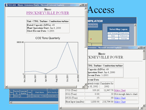
Lets look at CO2 sources in IL.
First, zoom in to an area of interest using the Zoom In Tool.
Next, choose the Identify Tool and click on a power plant. Note the information listed in the Results Window. These are the geodatabase featureclass attributes.
Now, for some real data integration. First select the hotlink tool and click on the power plant again. This time a ColdFusion request is sent to a ColdFusion application server in Kansas. The ColdFusion application server sends a request to the appropriate database, in this case an Oracle server in Illinois. The Kansas ColdFusion application server then generates a report based on the Illinois data sends the report back to the Web client in the form of an html report.
Finally, data from the Illinois RDBMS is returned to the Kansas server for creation of a real time graph.