by
Ricardo A. Olea and John C. Davis

|
Kansas Geological Survey |
Report to the Director of the
Kansas Geological Survey
University of Kansas
Open-file Report No. 2003-13
Released Feb. 2003, Electronic version created Feb. 2004
The Kansas Geological Survey measured water levels in 446 observation wells in the High Plains aquifer of Kansas in January 2002 and the Division of Water Resources measured an additional 737 wells during December 2001-February 2002. These measurements and other relevant information are stored in the WIZARD database maintained by the Kansas Geological Survey. The Kansas Geological Survey takes extensive precautions to ensure that the archived data are reliable and that the extracted measurements are free of extraneous effects that might mask variations in water-table elevation.
Sixty-six wells placed into the network of observation wells in the last 3 years have had a beneficial effect either by replacing old observation wells that had mechanical problems or by increasing the sensitivity of the network to fluctuations in water depth. We have now provided an update to the network configuration that requires reactivation of 21 observation wells that were not measured this season and the addition of wells at 13 other key sites in the network.
The network detected an average water-table decline of 2.6 ft during the last 5 years, with some wells showing declines in excess of 30 ft, and a reduction in the number of areas where the water table is rising. In 2001, the 5-year decline was 1.7 ft. The decline is most severe in Groundwater Management District 3 in the southwest corner of the state, where depletion has changed the nature of the variation in the water table. During the period 1997-2002, the groundwater level in GMD3 has declined an average of 4.1 ft.
List of Figures
List of Tables
List of Plates
The 2003 maps are presented as Adobe Acrobat PDF files. You will need the Acrobat PDF Reader, available free from Adobe, to read the maps.
The Kansas Geological Survey (KGS) and the Division of Water Resources (DWR) measure groundwater wells for the purpose of monitoring the elevation of the water tables in central and western Kansas. The High Plains aquifer is the largest and economically most important aquifer in the state. The High Plains aquifer is also the only aquifer in Kansas whose observation-well network is dense enough for spatial statistical analysis.
The objective of this report is to analyze and map fluctuations in depth to water in the High Plains aquifer for the purpose of:
The extraction of data from the WIZARD database was prepared at the KGS by Kurt Look of Computer Services, with assistance from Brownie Wilson of the Geohydrology Section. The extraction contains 1343 observation wells, which is 18 fewer wells than last year.
For year 2003, the extraction includes wells measured in January 2003 by KGS and during the period December 1, 2002, through February 28, 2003 by DWR. For convenience we refer to this period as the "2003 season." The same 3-month span was used to extract measurements made in 1997-1998 and in 2001-2002. For wells having more than one measurement during the 3-month interval, the extraction retains the shallowest reading.
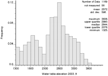
There are 118 observation wells that monitor aquifers other than the High Plains aquifer, leaving for this study the 1225 wells listed in Appendix A. The histogram in Figure 1 shows that only 1169 wells were actually measured this season, a decrease of four wells compared to last season and a decrease of 17 wells compared to five seasons ago.
Figure 1. Histogram of water-table elevations in the High Plains aquifer of Kansas for all observation wells actually measured during the season of December 2002-February 2003.
Figures 2 and 3 show the histogram by the organization responsible for the measurements. Table 1 gives numbers of wells itemized into official or annual wells, and "provisional" wells. "Provisional" wells are those which have been measured only since 2000. These wells become official observation wells if they can be measured consistently for 3 years and yield systematic readings. Finally, the 1169 wells measured this season are posted on Plate 1. Note that, for the sake of conciseness, the wells are labeled in Appendix A, Plate 1, and other maps with arbitrary sequential numbers rather than the longer U.S. Geological Survey (USGS) or KGS official well designations. The 56 wells without a 2003-season measurement are posted on Plate 2.
Figure 2. Histogram of water-table elevations in the High Plains aquifer of Kansas for the observation wells measured by the Kansas Geological Survey during the season of December 2002-February 2003.
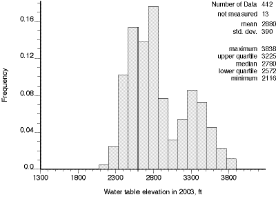
Figure 3. Histogram of water-table elevations in the High Plains aquifer of Kansas for the observation wells measured by the Division of Water Resources during the season of December 2002-February 2003.
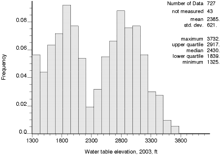
Table 1. Classification of year 2003 observation wells.
| Official | Provisional | Total | |||
|---|---|---|---|---|---|
| Measured | Not measured | Measured | Not measured | ||
| KGS | 419 | 10 | 23 | 3 | 455 |
| DWR | 701 | 40 | 26 | 3 | 770 |
| Total | 1120 | 50 | 49 | 6 | 1225 |
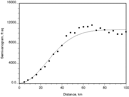
Plates 3 through 11 were prepared using geostatistical techniques which are adaptations of classical statistical methods that consider the autocorrelation inherent in spatial data such as water-table elevations (Olea, 1999). A central element of any geostatistical analysis is modeling spatial continuity by a semivariogram or equivalent function. Figure 4 shows a semivariogram for 2003 water-table elevations from the Kansas portion of the High Plains aquifer.
Figure 4. Semivariogram for the 2003 water-table elevation along N12E, the trend-free direction for the Kansas High Plains aquifer. Dots indicate estimated values based on 1169 measurements. The solid line is the best-fitting permissible model, which is a Gaussian model with a nugget effect of 67 ft2, a value of 10684 ft2 for the sill minus the nugget and a range of 62.7 km.
Crossvalidation is a geostatistical verification procedure that takes advantage of the spatial stochastic continuity of surfaces such as water-table elevation (Olea, 1999, Chapter 7). The method consists of removing one well from the data set and using the measurements of the remaining wells to estimate the elevation of the water table at the location of the deleted well. Then, the observation at the well is compared to the estimate, yielding a "crossvalidation error." The well is replaced and the process repeated for every observation of the water-table elevation--1169 times for the edited 2003 data set. Results can be used to analyze outliers in the data, the quality of the sampling procedure, and the power of the estimation method to predict water-table elevations at locations where no measurements have been made.
The scattergram of Figure 5 summarizes the results of cross validation for the original extraction, which shows three points with large errors that are the results of two problematic wells. Well no. 282 (24S 33W 9 CCD 01) came with wrong coordinates that placed it some 200 km to the east of its real location; well no. 1178 (4S 18W 27 DDD 02) was reported as tapping the High Plains aquifer, but this is not the case.
Figure 5. Crossvalidation results for the original extraction.

Figure 6 shows the crossvalidation results after eliminating well 1178 and correcting the location of well 282. These are the data used everywhere in this report other than in Figure 5.
Figure 6. Crossvalidation results for the edited extraction.
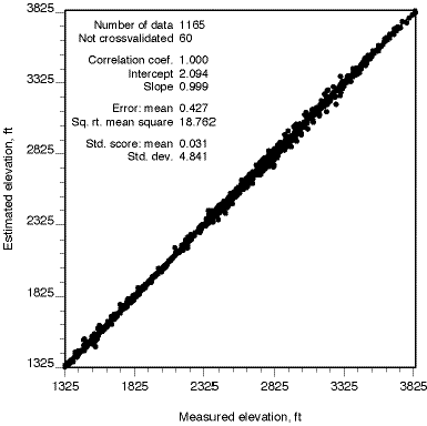
Plate 3 shows the estimated water-table elevation of the High Plains aquifer for the year 2003. The grid of values used for contouring was generated using universal kriging and the semivariogram shown in Figure 4.
The water-table surface does not appear to be much different from the surfaces observed in previous years (Miller, Davis, and Olea, 1998; Olea and Davis, 1999a; 2000a; 2001; 2002). This year-to-year similarity is partly the reason for mapping annual differences in water level, as the difference maps reveal more subtle variations than do the maps of elevation themselves.
Plate 4 shows the kriging standard deviation in water-table elevation associated with the water-table elevation map in Plate 3.
The distribution of the standard scores produced by crossvalidation does not deviate more that 9 percentage points from a standard normal distribution, indicating that it is reasonable to assume that kriging estimation errors are normally distributed. With this assumption, Figure 7 can be used to construct confidence intervals about the estimated surface.
Figure 7. Normal confidence factor versus probability. Given any kriging estimate, Prob[![]() ] gives the probability that the true value is within an interval given by (the estimated value minus
] gives the probability that the true value is within an interval given by (the estimated value minus ![]() ;
times the kriging standard deviation) and (the estimated value plus
;
times the kriging standard deviation) and (the estimated value plus ![]() times the kriging standard deviation).
times the kriging standard deviation).
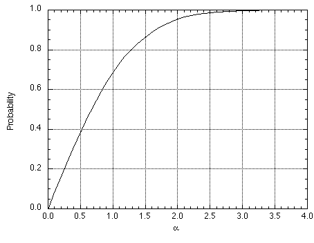
Figure 7 is a graph of a versus probability, where a is a factor that allows the determination of confidence intervals around a kriging estimate. For example, let us suppose that at a specific location the kriging estimate is 2000 ft and the kriging standard deviation is 10 ft and we want to know how often a confidence interval of one standard deviation around the estimate will capture the true value. Because Prob[1.0] is 0.68, then the probability is 68% that the true water level elevation lies between 1990 and 2010 ft. Similarly, if we want a confidence interval that captures the true value 95% of the time, we read across from 0.95 until reaching the curve, then down, which gives us a coefficient of 1.96. Hence, the true elevation is between 1980.4 and 2019.6 with 95% probability.
Figure 8 shows a cumulative distribution for the 1084 values of difference in depth to water between 1998 and 2003. On average, the depth to water in the observation wells increased by 4.7 ft, the largest change we have seen since we begun analyzing the network. The wells having the most extreme changes in depth are no. 12 (34S 35W 26ACC 01), in which the water level dropped 52.9 ft., and no. 881 (18S 38W 23BAB 01), in which the water level rose 18.5 ft.
Figure 8. Cumulative probability distribution of differences in depth to water during the last 5 years in the High Plains aquifer.
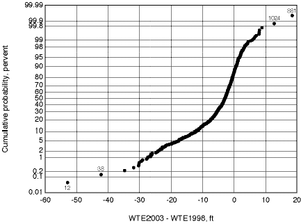
Figure 9 shows values of an experimental semivariogram and the best-fit model for the 1084 observation wells having measurements in both 1998 and 2003. This graph represents the nature of the spatial continuity of the 5-year change in water level throughout the High Plains aquifer. The large nugget effect is related to the high degree of disturbance that the aquifer has reached.
Figure 9. Omnidirectional semivariogram for differences in depth to water in the High Plains aquifer over the 5-year period 1998-2003. Dots denote calculated values based on 1084 observations. The line is the best-fit model, which is spherical with a nugget of 9.6 ft2, range of 33 km, and a value of 16.9 ft2 for the sill minus the nugget.
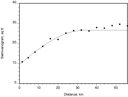
Figure 10 summarizes the results of crossvalidation. Because the 5-year change has no spatial trend, the crossvalidation has greater dispersion than does the crossvalidation of the water-table elevation itself (Figure 6). Note, however, that the square root of the mean squared error is smaller, implying that the estimation errors are smaller in spite of their lower spatial correlation. The wells with the largest crossvalidation errors in absolute value are no. 12 (34S 35W 26ACC 01), no. 38 (33S 35W 23CBB 01), no. 563 (27S 40W 25CBC 01), and no. 881 (18S 38W 23BAB 01), which mostly are the same wells that lie in the tails of the cumulative distribution. Other than their extreme values, nothing improper was found to suggest that these measurements are erroneous.
Figure 10. Crossvalidation estimates for changes in water-table elevation over the 5-year period from 1998 to 2003.
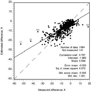
Plate 5 is a map of changes in water-table elevation during the 5-year period 1998-2003. Contour lines represent depth to water in 1998 minus the depth to water measured in 2003. Negative values, shown in shades of blue, represent areas where the water table is lower because of depletion. The map was prepared using ordinary kriging and the semivariogram shown in Figure 9. Unfortunately, all the features depicted seem to be real.
Compared to the same map for the previous 5-year (Olea and Davis, 2002), the most noticeable change is the reduction in areas with decreasing depth to water table, which this year are almost non-existent. Also, as shown in Figure 11, the rate of decline in the water table is worsening at an accelerated pace. The decline continues to be the most severe in Groundwater Management District 3, which is at the southwest corner of Plate 5, south of township 20S and west of range 20W (Figure 12). In this district, 337 wells account for an average increase in depth to water of 9.1 ft in the period 1998-2003. During 1997-2002 the increase in depth to water was 4.1 ft.
Figure 11. Rate of groundwater decline during the 2000s based on the average increase in depth to water during five-year periods.
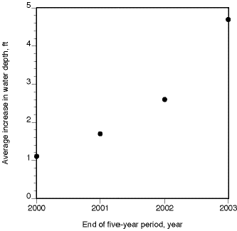
Figure 12. Cumulative probability distribution of differences in depth to water during 1998-2003 in the High Plains aquifer of Groundwater Management District 3.
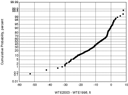
Plate 6 shows the kriging standard deviation of the estimated 5-year change in water level shown in Plate 5. Considering that normality of errors is still a reasonable assumption, use of these maps in combination with Figure 7 indicates that all areas where water level decline is greater than 5 ft (i.e., all areas below the -5 ft contour line) have a large probability of being real and should not be dismissed as artifacts of the sampling or contouring procedure.
Figure 13 is a cumulative probability distribution for the most recent 12-month change in depth to water. The curve is based on 1134 observations whose mean is -1.9 ft, denoting an average decline in the water level that is twice the average decline for 2001-2002 measurements (Olea and Davis, 2002).
Figure 13. Cumulative probability distribution of the change in depth to water during the last year, 2002-2003.
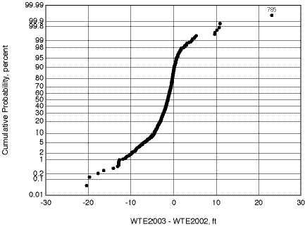
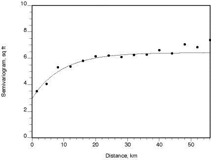
Figure 14. Omnidirectional semivariogram for differences in depth to water in the High Plains aquifer in 2002-2003. Dots denote calculated values based on 1134 measurements. The line is the best-fit model, which is exponential with a nugget of 3 ft2, range of 28.2 km, and a value of 3.5 ft2 for the sill minus the nugget.
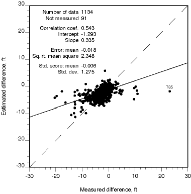
Well no. 785 (22S 17W 05BBC 02) is the only outlier in the cumulative distribution of Figure 13. Curiously, last year this well had the largest increase in water depth for the season, which suggests that the 2002 reading of depth to water is an erroneous observation. This season, well no. 785 also has the largest crossvalidation error (Figure 15).
Figure 15. Crossvalidation results for changes in water-level elevation during 2001.
Examination of the kriging standard errors in Plate 8 combined with the probability limits graphed in Figure 7, shows that in many areas the mapped changes in water level are less than the 95% confidence limits. Therefore, Plate 7 is not a reliable guide to the short-term behavior of the aquifer.
As discussed in Section 6, kriging standard deviations can be used to assess the reliability of estimates. The kriging standard deviation depends only on the form of the semivariogram and the locations of wells--not on the individual measurement values. This circumstance is ideal for network analysis because experiments can be performed using hypothetical well locations even though there are no measurements for these imaginary wells. Plate 9 shows the kriging standard deviation that would result if data were available for the 56 observation wells that were not measured during the 2003 season.
The Kansas Geological Survey and the Division of Water Resources have agreed that the observation-well network should be arranged in so that the kriging standard deviation is less than 10 ft everywhere within the High Plains aquifer except near the aquifer boundaries. This section updates past years recommendations whose intent was to completely eliminate areas within the network where the kriging standard deviation exceeds the agreed-upon limits (Olea, 1997a; 1997b; Olea and Davis, 1999b; 2000a; 2000b; 2001; 2002). Table 2 lists 12 of the 56 wells that were not measured this season. As demonstrated by Plate 10, if these 12 wells had been measured, 7 areas where the uncertainty in the network exceeded acceptable limits would have been eliminated and three other areas would have been reduced in size.
Table 3 has one observation well that did not appear in the 2003 data extraction, apparently because this well is no longer included in the network. This well should be reactivated or replaced by one of the numerous nearby wells.
Table 2. Observation wells that should be measured next year.
| Seq. no. | USGS ID | KGS ID | Agency |
|---|---|---|---|
| 36 | 370949101125501 | 33S 36W 22ADC 01 | KGS |
| 50 | 371339101025301 | 32S 34W 32BBB 01 | KGS |
| 99 | 372549100485501 | 30S 32W 22BBB 01 | KGS |
| 236 | 375159100384101 | 25S 30W 20BCB 01 | KGS |
| 240 | 375257100432901 | 25S 31W 16ACA 01 | KGS |
| 564 | 374023098190401 | 27S 09W 29AAA 01 | DWR |
| 813 | 381504098465101 | 21S 13W 05CBD 01 | DWR |
| 968 | 384323101372101 | 15S 39W 26ACC 01 | DWR |
| 1052 | 391637100345901 | 09S 29W 17BAB 01 | DWR |
| 1059 | 391821100320601 | 09S 29W 03AAA 01 | DWR |
| 1174 | 393954100405901 | 04S 30W 34BCB 02 | DWR |
| 1188 | 394248100334001 | 04S 29W 10DCC 01 | DWR |
Table 3. Well not included in the 2003 data extraction that should be reactivated.
| Seq. no. | USGS ID | KGS ID | Agency |
|---|---|---|---|
| 2615 | 375811097373001 | 24S 03W 14BBB 01 | DWR |
Finally, it will be necessary to add 13 new observation wells at or near the locations listed in Table 4; this will completely eliminate areas inside the High Plains aquifer where the kriging standard deviation is greater than 10 ft. These locations have been determined by placing hypothetical observation wells at the centers of the hexagons shown in Figure 16. The most efficient way of sampling a two-dimensional continuous variable is to take measurements at the centers of regular hexagons that form a tessellation of the area of interest (Olea, 1984). Based on past experience, there is some leeway in locating wells; they do not have to be at the exact centers of perfect hexagons in a network. Usually, if a replacement well is in the same section as the well it replaces, or in any of the contiguous sections, the replacement well will be almost as effective in reducing the standard deviation.
Figure 16. Hexagonal pattern used to graphically locate sites where new wells are needed.
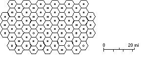
Table 4. Ideal locations for new observation wells.
| Seq. no. | UTM X (meters) | UTM Y (meters) | Legal location |
|---|---|---|---|
| 3001 | 328000 | 4220000 | 22S 33 W 29 ACD |
| 3002 | 340000 | 4218000 | 22S 32 W 34 CBA |
| 3003 | 335000 | 4199000 | 24S 32 W 31 BDC |
| 3004 | 366000 | 4179000 | 26S 29 W 32 BBA |
| 3005 | 300000 | 4164000 | 28S 36 W 21 BAC |
| 3006 | 292000 | 4160000 | 28S 37 W 34 CDA |
| 3007 | 316000 | 4133000 | 31S 35 W 25 BAD |
| 3008 | 330000 | 4142000 | 30S 33 W 27 BCD |
| 3009 | 346000 | 4150000 | 29S 31 W 32 BBC |
| 3010 | 334000 | 4137000 | 31S 33 W 11 ACD |
Based on geostatistical analyses of 1169 measurements of water-table elevations in the High Plains aquifer taken during December 2002 through February 2003; 1134 measurements of the difference in depth to water during the last year; and 1084 measurements of the difference in depth to water over a 5-year period, we may note that:
Miller, R.D., J.C. Davis, and R.A. Olea, 1998, Annual water level raw data report for Kansas: Kansas Geological Survey Open-File Report No. 98-7, 275 p., 6 plates, 1 compact disk. [Available Online]
Olea, R.A., 1984, Sampling design optimization for spatial functions: Mathematical Geology, vol. 16, no. 4, p. 369-392.
Olea, R.A., 1997a, Sampling analysis of the annual observation water-level wells in Kansas: Kansas Geological Survey Open-File Report No. 97-73, 44 p.
Olea, R.A, 1997b, Modification to the High Plains aquifer observation network expansion in Open-File Report No. 97-73: Open-file Report 97-84, Kansas Geological Survey, Lawrence, Kansas, 3 p.
Olea, R.A., 1999, Geostatistics for Engineers and Earth Scientists: Kluwer Academic Publishers, Norwell, Massachusetts, 303 p.
Olea, R.A., and J.C. Davis, 1999a, Sampling analysis and mapping of water levels in the High Plains aquifer of Kansas: Kansas Geological Survey Open-File Report No. 99-11, 35 p., 9 plates.
Olea, R.A., and J.C. Davis, 1999b, Optimization of the High Plains aquifer water-level observation network: Kansas Geological Survey Open-File Report No. 99-15, 8 p., 3 plates.
Olea, R.A., and J.C. Davis, 2000a, Year 2000 sampling analysis and mapping of water levels in the High Plains aquifer of Kansas: Kansas Geological Survey Open-File Report No. 2000-13, 33 p., 5 plates.
Olea, R.A., and J.C. Davis, 2000b, Year 2000 proposed additions to the High Plains aquifer water-level observation network: Kansas Geological Survey Open-File Report No. 2000-17, 7 p., 1 plate.
Olea, R.A., and J.C. Davis, 2001, Year 2001 mapping of water levels in the High Plains aquifer of Kansas and analysis of the monitoring network: Kansas Geological Survey Open-File Report No. 2001-6, 49 p., 8 plates. [Maps Available Online]
Olea, R.A., and J.C. Davis, 2002, Geostatistical analysis and mapping for year 2002 water levels in the High Plains aquifer of Kansas: Kansas Geological Survey Open-File Report No. 2002-14, 34 p., 16 plates. [Maps Available Online]