by
John C. Davis

|
Kansas Geological Survey 1930 Constant Avenue Lawrence, Kansas 66047-3726 |
Report to the Director of the
Kansas Geological Survey
University of Kansas
Open-file Report No. 2002-5
Released Feb. 8, 2002, Electronic version created June 2002
The primary variable measured in the water well observation program is depth to water in an observation well. This primary variable is associated with three secondary variables; the ground elevation, east-west coordinate, and north-south coordinate of the well. The secondary variables serve to locate the primary variable in space, and make it possible to determine spatial relationships between observation wells, including mapping the water table and calculating changes in aquifer volume. Historically, the three location variables were determined initially by the U.S. Geological Survey for each well and not re-determined unless a serious error in the original coordinates was suspected. In the 1997 ground water observation measurement program conducted by the Kansas Geological Survey, the geographic (latitude and longitude) coordinates of all wells were re-determined by GPS techniques. In subsequent year's measurement programs, all observation wells were again re-determined by GPS. "Selective Availability," which limited the resolution of GPS measurements, was turned off by the Federal government in 2001, so locations determined that year were substituted for previous determinations. For a few locations where year 2001 GPS measurements were not taken, measurements made in 1999 are used.
In addition, several secondary characteristics of the observation wells and of the measurement procedure were noted in order to determine if these might influence the quality of the measurements being made (these measurements are referred to as exogenous variables). As part of the quality control program, water level measurements were repeated two or more times on 171 wells, yielding a collection of 225 quality control observations. Because these data include replicates, they provide an additional check on estimates of the influence of well conditions or measuring techniques on water levels. A subsequent round of measurements resampled 50 wells selected at random from the original set for quality assurance purposes. These wells were measured two or more times for a set of Ill quality assurance values.
The primary variable, depth to water, changes with geographic location and differences in topography so much that these factors will overwhelm all other sources of variation. Because of this, any errors in location may have a profound effect on the water table elevation. To avoid the complications of simultaneously considering uncertainties in the secondary variables, this statistical quality control study is based on first differences (specifically, the difference between 2002 and 2001 depth-to-water measurements). The secondary variables cancel out, leaving only the difference in depth, which is numerically identical to the year's change in water level. In this statistical quality control study, the difference between 2002 and 2001 corrected depth measurements is abbreviated "'02-'02." If the water table is lower this year, the variable '02-'01 win be a positive number. Because all wells measured in the current program were also measured in 2001, there are a total of 495 wells having the variable '02-'01. This is one more than the number of measurements available last year.
The objective in our quality control study is to identify and assess possible sources of unwanted variation in water level measurements made by the KGS. The purpose of the analysis is to provide guidance to the KGS field measurement program, to suggest ways in which field measurements might be improved, and to provide information necessary to identify past or current measurements that are suspect. The statistical quality control and field measurement programs have been intimately intertwined from the outset when the KGS assumed responsibility in 1997 for measuring observation wells formerly measured by the USGS. A comparison of results from 2002 with those from previous years shows that the desired improvements in the measurement program are being achieved through quality control.
| Analysis of Variance Table for Initial Model | |||||
|---|---|---|---|---|---|
| Source | DF | Sum of Squares | Mean Square | F Ratio | Prob>F |
| Model | 29 | 492.1235 | 16.9698 | 2.8728 | <0.0001 |
| Measurer | 7 | 98.8865 | 14.1266 | 2.3915 | 0.0207* |
| Well Access | 1 | 28.1042 | 28.1042 | 4.7577 | 0.0297* |
| Weighted Tape | 1 | 4.8052 | 4.8052 | 0.8135 | 0.3676ns |
| Well Use | 4 | 78.3423 | 19.5856 | 3.3156 | 0.0108* |
| Oil on Water | 1 | 31.8955 | 31.8955 | 5.3995 | 0.0206* |
| Chalk Cut Quality | 2 | 34.0758 | 17.0379 | 2.8843 | 0.0569ns |
| Aquifer Code | 13 | 249.7334 | 19.2103 | 3.2520 | <0.0001** |
| Error | 462 | 3733.4864 | 8.0811 | ||
| Total | 491 | 3221.2218 | |||
| RSquare | 0.1528 | ||||
| ns = Not significant; * = Significant; ** = Highly significant | |||||
A revised model was run that combined aquifers into classes similar to those used in 1997 through 2001. This 5-part classification distinguishes between (1) wells that tap alluvial aquifers, (2) wells that tap both alluvial aquifers and other unconsolidated aquifers, (3) wells drawing from the High Plains aquifer, (4) wells into bedrock aquifers, and (5) wells that draw from both bedrock and unconsolidated aquifers. This fias the effect of reducing the degrees of freedom required for the model and thus increasing the sensitivity of the analysis for detecting other influences.
| Analysis of Variance table for Grouped Aquifers | |||||
|---|---|---|---|---|---|
| Source | DF | Sum of Squares | Mean Square | F Ratio | Prob>F |
| Model | 20 | 398.4342 | 19.9217 | 3.3241 | <.0001** |
| Measurer | 7 | 96.5845 | 13.7478 | 2.3022 | 0.0258* |
| Well Access | 1 | 27.2153 | 27.2153 | 4.5410 | 0.0336* |
| Weighted Tape | 1 | 4.7891 | 4.7891 | 0.7991 | 0.3718ns |
| Well Use | 4 | 90.3622 | 22.5906 | 3.7694 | 0.0050** |
| Oil on Water | 1 | 40.7660 | 40.7660 | 6.8021 | 0.0094** |
| Chalk Cut Quality | 2 | 32.4306 | 16.2153 | 2.7056 | 0.0679ns |
| Aquifer Group | 4 | 156.0442 | 39.0111 | 6.5092 | <.0001** |
| Error | 471 | 2822.7876 | 5.9932 | ||
| Total | 491 | 3221.2218 | |||
| RSquare | 0.1237 | ||||
| ns = Not significant; * = Significant; ** = Highly significant | |||||
Measurer, Well Access, Well Use, Oil on Water, and Aquifer Group are signficant sources of variation in the revised model, similar to last year except that Oil on Water is significant and Chalk Cut Quality is not. Unfortunately, past models are not directly comparable because there are different numbers of degrees of freedom assigned to some variables, and the response (annual change in water level) has significantly different variances from year to year. It has been noted that the variance of the response variable seems to alternate in magnitude every other year; this pattern continues in 2002 which has a significantly lower variance than measurements made in 2001. Although the year-to-year changes in total variance are highly significant, the cause is speculative (Davis, 2001).
One way to improve the statistical results of the measurement program is to discard wells in which exogenous variables make unusually high contributions to the total variance, arguing that the readings from such wells are atypical and likely erroneous. Only six wells exhibited extreme behavior in 2001 and one of these was deleted from the network because it was plugged and could not be measured.
|
|
|
||||||||||||||||||||||||||||||||||||||||||||||||||||||
|
|
|
||||||||||||||||||||||||||||||||||||||||||||||||||||||
There are significant differences between measurers, mostly attributable to JDM (who tended to produce shallower than expected measurements) and DRL and NC (who tended to record deeper measurements). Note that both JDM and NC are first-time measurers.
Water levels measured in 2002 in exclusively Cretaceous aquifers (Group 1) show declines of over 5.3 ft. from 2001. The water level in the Ogalalla aquifer (Group 4) tends to be over 3.5 ft. deeper than last year. Measurements made in wells tapping alluvial aquifers (Group 2) show a decline of 2.2 ft., whereas last year these wells had a slight increase in average water level. Wells in alluvial plus other sources (Group 3) show a decline in water level of 2.3 ft. Water levels in wells tapping Cretaceous aquifers plus Quaternary and/or Tertiary aquifers (Group 5) tend to be 2.6 ft. deeper on average this year. There are highly significant differences of the annual change in water level among aquifers, mostly due to the behavior of Cretaceous wells. (Statistics for 2002 can only be compared in detail with those from 2001 because of the change in responsibility for wells in two counties that occurred after year 2000.)
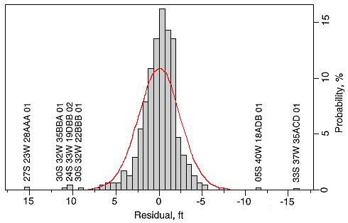
The ANOVA equation can be used to create an expected value and residual (difference between observed and expected value) for each well. The distribution of residuals should be approximately normal. Examination of the residual outliers will reveal any well measurements which cannot be explained by extreme combinations of the different sources of variation. The residual plot, shown in Figure 1, deviates somewhat from normality; it is more peaked than normal, and slightly skewed to negative values. Outliers, or extreme values, are measurements which differ from their expected values by more than ±10 feet. Six wells have been identified by this process. These wells show changes in water level between 2001 and 2002 that are outside the range expected. These well measurements may be correct and reflect unusual changes in aquifer level; the wrong wells may have been measured in one year or the other; or changes in wen construction or other factors may have altered the measurability of a well. The six wells, with their residuals, are:
| Well ID | Residual, ft. |
|---|---|
| 33S 37W 35ACD 01 | -15.9 |
| 05S 4OW 18ADB 01 | -11.8 |
| 30S 32W 22BBB 01 | 10.0 |
| 24S 33W 19DBB 02 | 10.5 |
| 30S 32W 35BBA 01 | 10.8 |
| 27S 23W 28AAA 01 | 15.5 |
A positive residual indicates that the 2002 water level is lower than predicted in a well with a declining water level, or is not as high as predicted in a well with an increasing water level. A negative residual indicates that the 2002 water level has declined less than predicted in a well with a declining water level, or has risen more than predicted in a well with a rising water table. One well, 27S 23W 28AAA 01, has poor access and a weight could not be used on the tape; wells with such deficiencies should be considered for replacement. The remaining wells have very limited histories of measurement, have been unusually variable from year to year, and show an exceptionally large drawdown this year. However, because only a few wells had questionable measurements, the decision was again made not to have a post-season remeasurement program in 2002.
Within the QA data set alone, there are no significant contributions due to Measurer. Geological Units shows significant differences between levels in the QA data set, due almost entirely to the different behavior of KJ and QA from 2001 to 2002.
The Quality Control program has achieved its objectives of identifying and quantifying sources of unwanted variation in observation well data collection, and in flagging wells whose measurements require verification. It detected a small number of spurious values, confirming the benefits of "cleaning" the data base in past years. As the Quality Control process is routinely applied to KGS observation well measurements in the future, and particularly if it is applied to the entire Kansas observation well network, the quality of the groundwater measurement data will continue to be progressively improved with time.
Figure 1--Histogram of residuals from predicted change in water level '02-'01, as estimated by regression model. Curve is fitted normal distribution with same mean and variance as residuals. Wells whose change in water level deviates more than 10 feet from the predicted value are indicated.
Miller, R.D., J.C. Davis, and R.A. Olea, 1997, Acquisition Activity, Statistical Quality Control, and Spatial Quality Control for 1997 Annual Water Level Data Acquired by the Kansas Geological Survey: Kansas Geological Survey Open-File Report No. 97-33, 45 p. [Available Online]
Miller, R.D., J.C. Davis, and R.A. Olea, 1998, 1998 Annual Water Level Raw Data Report for Kansas: Kansas Geological Survey Open-File Report No. 98-7, 275 p., 6 plates, and 1 compact disk. [Available Online]
Next Page--Appendix A--not yet available.