by
Ricardo A. Olea and John C. Davis

|
Kansas Geological Survey |
Report to the Director of the
Kansas Geological Survey
University of Kansas
Open-file Report No. 2002-14
Released April 2002, Electronic version created June 2002
Sixty-six wells placed into the network of observation wells in the last 3 years have had a beneficial effect either by replacing old observation wells that had mechanical problems or by increasing the sensitivity of the network to fluctuations in water depth. We have now provided an update to the network configuration that requires reactivation of 21 observation wells that were not measured this season and the addition of wells at 13 other key sites in the network.
The network detected an average water-table decline of 2.6 ft during the last 5 years, with some wells showing declines in excess of 30 ft, and a reduction in the number of areas where the water table is rising. In 2001, the 5-year decline was 1.7 ft. The decline is most severe in Groundwater Management District 3 in the southwest corner of the state, where depletion has changed the nature of the variation in the water table. During the period 1997-2002, the groundwater level in GMD3 has declined an average of 4.1 ft.
List of Figures
List of Tables
List of Plates The 2002 maps are presented as Adobe Acrobat PDF files. You will need the Acrobat PDF Reader, available free from Adobe, to read the maps.
The objective of this report is to analyze and map fluctuations in depth to water in the High Plains aquifer for the purpose of:
For year 2002, the extraction includes wells measured during the period December 1, 2001, through February 28, 2002. For convenience we refer to this period as the "2002 season." The same 3-month span was used to extract measurements made in 1996-1997 and in 2000-2001. For wells having more than one measurement during a 3-month interval, the shallowest reading was used.
There are 122 observation wells that monitor aquifers other than the High Plains aquifer, leaving for this study the 1239 wells listed in Appendix A. Two wells, no. 762 (22S 15W 03AAA 01) and no. 763 (22S 15W 03AAA 02), are so close together that they have the same state plane coordinates, which results in identical UTM coordinates if these are calculated from the legal description rather than measured in the field with a GPS device. Thus well no. 763 was not included in this analysis because the geostatistical techniques employed do not allow multiple measurements at the same location. Consequently, the number of wells used in this study is 1238, an increase of four wells over the number used a year ago (Olea and Davis, 2001).
The observation wells used in the study are summarized in Table 1 and posted on Plates 1 and 2. "Provisional wells" are those which have been measured only since 1999. These wells become official observation wells if they can be measured consistently for 3 years and yield systematic readings. Note that the wells are labeled on the maps with arbitrary sequential numbers rather than the longer U.S. Geological Survey (USGS) or KGS official well designations. The water-table elevations measured in 1173 wells are summarized in graphic form in Figure 1.
Table 1. Classification of year 2002 observation wells.
| Network | Provisional | Total | |||
|---|---|---|---|---|---|
| Measured | Not measured | Measured | Not measured | ||
| KGS | 410 | 10 | 36 | 3 | 459 |
| DWR | 705 | 47 | 22 | 5 | 779 |
| Total | 1115 | 57 | 58 | 8 | 1238 |
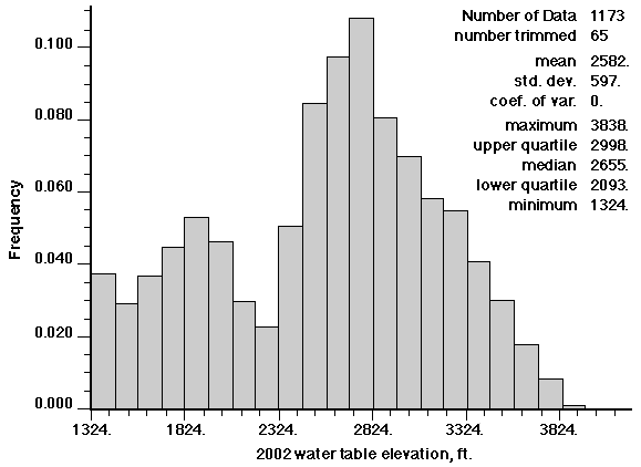
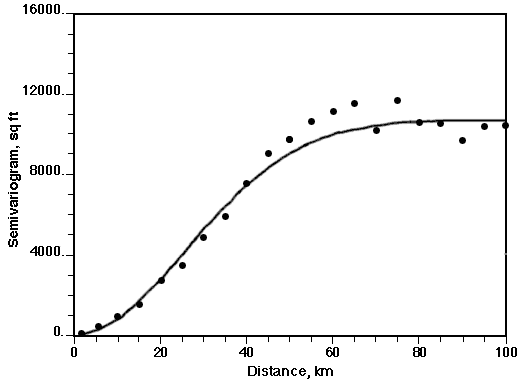
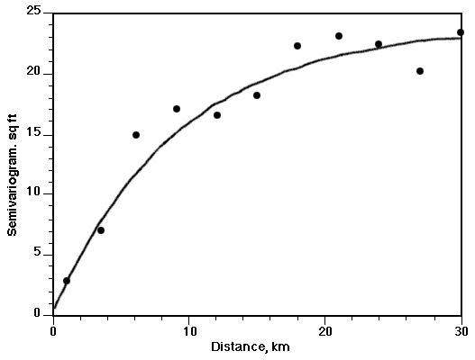
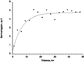
Figure 2. Semivariogram of the 2002 water-table elevation along N10E, the trend-free direction of the Kansas High Plains aquifer. Dots indicate estimated values. The solid line is the best-fitting permissible model, which is Gaussian with a nugget value of 68 ft2, a value of 10645 ft2 for the sill minus the nugget, and a range of 63.5 km.
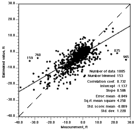
The most anomalous wells are no. 254 (28S 42W 20BCC 01) and no. 905 (17S 42W 28DAB 01). Inspection of the measurements and the locations of these wells does not suggest anything improper in the data collection or recording.
5. Water-table Elevation in the High Plains Aquifer
Plate 3 shows the estimated water-table elevation of the High Plains aquifer for the year 2002. The grid of values used for contouring was generated using universal kriging and the semivariogram shown in Figure 2.
The water-table surface does not appear to differ much from the surfaces observed in previous years (Miller, Davis, and Olea, 1998; Olea and Davis, 1999a; Olea and Davis, 2000a; Olea and Davis, 2001). This year-to-year similarity is partly the reason for mapping annual differences in water level, as the difference maps reveal more subtle variations than do the maps of elevation themselves.
6. Kriging Standard Deviation for Water Table
Plate 4 shows the kriging standard deviation in water-table elevation associated with the water-table elevation map in Plate 3.
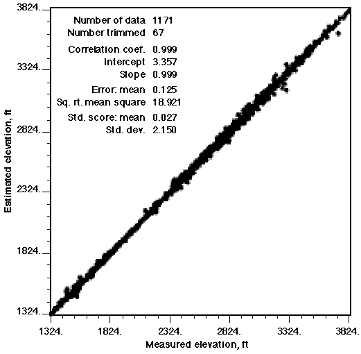
The distribution of the differences between observations and estimations seen in crossvalidation indicates that it is reasonable in this instance to assume that the kriging estimation errors are normally distributed. With this assumption, Figure 4 can be used to estimate confidence intervals about the kriged surface.
For example, if at a specific location the kriging estimate is 3000 ft and the kriging standard deviation is 10 ft, then the probability is 90% that the true water level elevation lies between 2983.5 and 3016.5 ft and the probability is 99% that the true elevation is between 2974.2 and 3025.8 ft.
Figure 4. Standard normal score versus probability. Given any kriging estimate and a value of the standard normal score a, the ordinate gives the probability that the true value is within an interval given by (the estimated value minus a times the kriging standard deviation) and (the estimated value plus a times the kriging standard deviation).
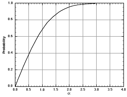
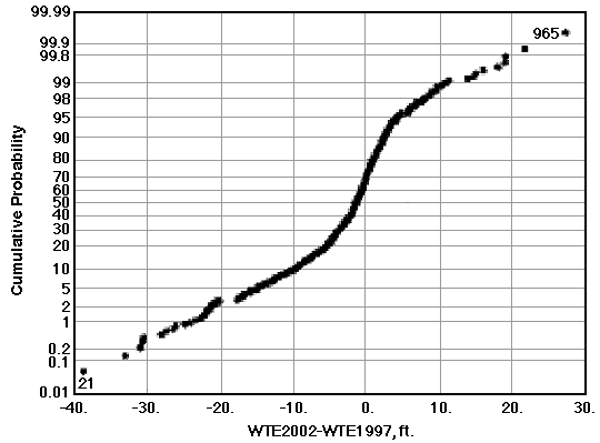
Figure 6. Experimental semivariogram of differences in depth to water over the 5-year period 2002-1997 in 1085 observation wells in the High Plains aquifer. Line is the best-fit model, which is exponential with a nugget of 0.3 ft2, range of 27.7 km, and a value of 23.5 ft2 for the sill minus the nugget.
General trends in the mapped surface are similar to those observed on previously computed maps of changes in water level over 5-year periods (Miller, Davis, and Olea, 1998; Olea and Davis, 1999a; Olea and Davis, 2000a; Olea and Davis, 2001). However, the rate of depletion seems to be worsening at an accelerated pace. The average increase in depth to the water table in an observation well is 2.6 ft over the period 1997-2002, which is greater than the 1.7 ft average increase in depth seen during the previous 5-year period (1996-2001) or the 1.1 ft average increase in depth for 1995-2000.
Plate 6 shows the kriging standard deviation of the estimated 5-year change shown in Plate 5. Use of these maps in combination with Figure 4 indicates that all areas where depletion is greater than 5 ft (i.e., all areas below the -5 ft contour line) are real and cannot be dismissed as artifacts of the contouring procedure. This also is true for the much smaller areas of recharge where the increase in water level is greater than 5 ft.
8. Changes in the Water Table Over the Past Year
Figure 8 is a cumulative probability distribution of the 12-month change in depth to water. The curve is based on 1143 observations whose mean is -0.95 ft, denoting an average lowering in the water level of almost 1 foot during 2001.
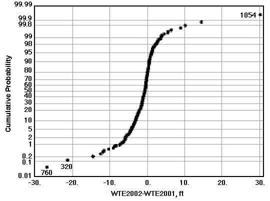
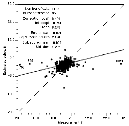
Figure 9. Experimental semivariogram of differences in depth to water in 1143 observation wells in the High Plains aquifer for the period 2001-2002. Line is the best-fit model, which is exponential with a nugget of 0.3 ft2, range of 20.4 km, and value of 4.4 ft2for the sill minus the nugget.
The Kansas Geological Survey and the Division of Water Resources have agreed that the observation-well network should be arranged in such a way that the kriging standard deviation is less than 10 ft everywhere within the High Plains aquifer except near the aquifer boundaries. This section updates recommendations made in past years whose intent was to completely eliminate areas within the network where the kriging standard deviation exceeds the agreed-upon limits (Olea, 1997a; Olea, 1997b; Olea and Davis, 1999b; Olea and Davis, 2000a; Olea and Davis, 2000b; Olea and Davis, 2001). Table 2 lists 17 of the 65 wells that were not measured this season; if these wells had been measured, all areas where uncertainty in the network exceeds acceptable limits would have been eliminated or significantly reduced.
Table 2. Observation wells that should be measured next year.
| Seq. no. | USGS ID | KGS ID | Agency |
|---|---|---|---|
| 91 | 371801101363101 | 32S 39W 06BBB 01 | DWR |
| 110 | 372128101065001 | 31S 35W 15BAA 01 | KGS |
| 131 | 372405100515601 | 30S 32W 31BAB 01 | KGS |
| 233 | 373412101180101 | 28S 36W 31BDD 01 | KGS |
| 347 | 374206101191201 | 27S 37W 13BD 01 | DWR |
| 388 | 374417100280401 | 26S 29W 35CCC 01 | KGS |
| 454 | 374926099071601 | 25S 16W 31DCC 01 | DWR |
| 468 | 375008099141501 | 25S 17W 31BBD 01 | DWR |
| 547 | 375521100363801 | 24S 30W 33ADD 01 | KGS |
| 554 | 375557100515801 | 24S 32W 30DDD 01 | KGS |
| 644 | 380106100434402 | 23S 31W 28CDD 02 | KGS |
| 669 | 380217098071401 | 23S 07W 20BCA 01 | DWR |
| 736 | 380801100554801 | 22S 33W 22BAA 01 | KGS |
| 769 | 381120098434802 | 21S 13W 27DDD 02 | DWR |
| 795 | 381504098465101 | 21S 13W 05CBD 01 | DWR |
| 969 | 384323101372101 | 15S 39W 26ACC 01 | DWR |
| 976 | 384644101420801 | 15S 39W 06CBC 01 | DWR |
Table 3 lists four observation wells that did not appear in the 2002 data extraction, apparently because these wells are no longer included in the network. These wells should be reactivated or replaced by nearby wells.
Table 3. Wells not included in the 2002 data extraction that should be reactivated.
| Seq. no. | USGS ID | KGS ID | Agency |
|---|---|---|---|
| 2001 | 372944100474902 | 29S 32W 26CBB 02 | KGS |
| 2002 | 372855100335801 | 29S 30W 35ACD 01 | KGS |
| 2003 | 372816100441901 | 30S 31W 05BBB 01 | KGS |
| 2615 | 375811097373001 | 24S 03W 14BBB 01 | DWR |
Finally, it is necessary to add 13 new observation wells at or near the locations listed in Table 4; this will completely eliminate areas inside the High Plains aquifer that have kriging standard deviations greater than 10 ft. These locations have been determined by placing hypothetical observation wells at the centers of the hexagons shown in Figure 11. The most efficient way of sampling a two-dimensional continuous variable is to take measurements at the centers of regular hexagons that form a tessellation of the area of interest. Based on past experience, there is some leeway in locating wells and they do not have to be at the center of a perfectly hexagonal network. Usually, if a replacement well is in the same section as the well it replaces, or in any of the contiguous sections, the replacement well will be almost as effective in reducing the kriging standard deviation. Plate 10 confirms that, under the proposed enhancements, the kriging standard deviation is less than 10 ft at all locations except adjacent to the boundaries of the aquifer.
Table 4. Ideal locations for new observation wells.
| Seq. no. | UTM X (meters) | UTM Y (meters) | Legal location |
|---|---|---|---|
| 3001 | 305000 | 4480000 | 4S 35W 5CCA |
| 3002 | 312500 | 4397000 | 4S 35W 13DAA |
| 3003 | 352000 | 4378000 | 6S 31W 12DDC |
| 3004 | 335000 | 4355000 | 8S 32W 29ACD |
| 3005 | 351000 | 4193000 | 25S 31W 14CDD |
| 3006 | 350000 | 4183000 | 26S 31W 15CCA |
| 3007 | 318000 | 4139000 | 31S 34W 6ACD |
| 3008 | 319000 | 4130000 | 31S 34W 32CDD |
| 3009 | 312000 | 4160000 | 34S 35W 3BDC |
| 3010 | 343000 | 4130000 | 31S 32W 35CAD |
| 3011 | 572000 | 4207000 | 23S 8W 34ADA |
| 3012 | 348000 | 4347000 | 9S 31W 22AAC |
| 3013 | 300000 | 4119000 | 33S 36W 8ABA |
Figure 11. Hexagonal pattern used graphically to locate sites where new wells are needed.
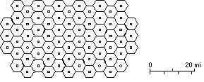
Figure 12 and Table 5 show five semivariograms, one for each groundwater management district. Also shown for comparison is the aquifer-wide average semivariogram from Figure 2.
Figure 12. Semivariogram models along the trend-free direction for each groundwater management district and for the entire aquifer. Table 5 lists values of the critical parameters.
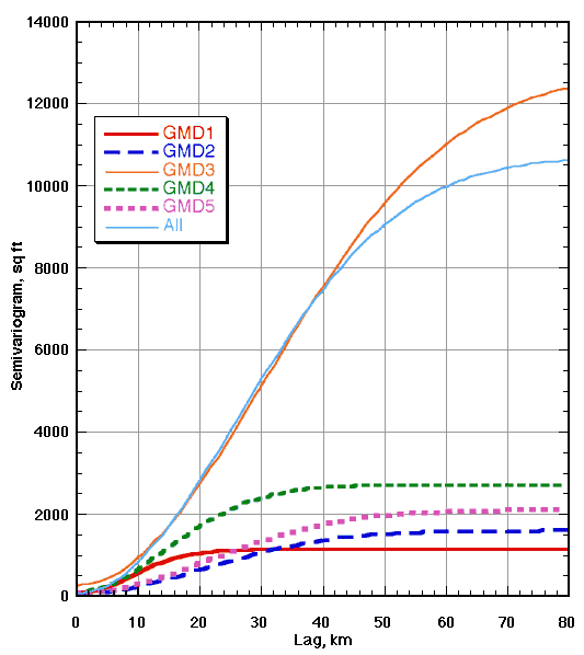
Table 5. Parameters for the semivariogram models in Figure 11. All models are Gaussian.
| Area | Measurements | No trend (degree) |
Nugget (sq ft) | Sill (sq ft) |
Range (km) | AIC |
|---|---|---|---|---|---|---|
| GMD1 | 126 | N8E | 60 | 1118 | 21.894 | -33.9 |
| GMD2 | 103 | N2W | 43 | 1587 | 50.916 | -30.8 |
| GMD3 | 378 | NS | 272 | 12774 | 74.290 | -100.0 |
| GMD4 | 339 | N22W | 77 | 2695 | 35.766 | -26.8 |
| GMD5 | 227 | N10W | 69 | 2105 | 52.592 | -73.5 |
| Entire aquifer | 1173 | N10E | 68 | 10713 | 63.528 | -109.2 |
Although the semivariograms of the other districts have sills that are significantly different than that of the semivariogram for the entire aquifer, the kriging standard deviation maps of the districts show minimal differences, especially that of GMD5. The kriging standard deviations for GMD2 are approximately 20% lower than standard deviations calculated across the entire aquifer; those for GMD1 and GMD4 are about 20% higher.
Because the spatial continuity of the water-level elevation differs from district to district, the network density should also differ in order to maintain uniform reliability. However, the High Plains aquifer observation-well network is designed as a constant-density network. Reducing the average kriging standard deviation by half within an area would require that the number of wells be increased 16 fold (Olea, 1984). The obvious impracticality of such a step means we will have to live with varying network reliability, which may even become more severe if groundwater depletion continues to worsen.
Except in GMD3, using semivariogram models by district rather than statewide does not significantly change the contour maps of water-table elevation, as can be seen by comparing Plates 3 and 16. Increase in the nugget has the effect of increasing the smoothing in the kriging estimates, observable in Plate 17.
11. Conclusions and Recommendations
Based on geostatistical analyses of 1173 measurements of water-table elevations in the High Plains aquifer taken during December 2001 to February 2002, 1143 measurements of the difference in depth to water during the last year, and 1085 measurements of the difference in depth to water over a 5-year period, we may note that:
Olea, R.A., 1984, Sampling design optimization for spatial functions: Mathematical Geology, vol. 16, no. 4, p. 369-392.
Olea, R.A., 1997a, Sampling analysis of the annual observation water-level wells in Kansas: Kansas Geological Survey Open-File Report No. 97-73, 44 p.
Olea, R.A, 1997b, Modification to the High Plains aquifer observation network expansion in Open-File Report No. 97-73: Open-file Report 97-84, Kansas Geological Survey, Lawrence, Kansas, 3 p.
Olea, R.A., 1999, Geostatistics for Engineers and Earth Scientists: Kluwer Academic Publishers, Norwell, Massachusetts, 303 p.
Olea, R.A., and J.C. Davis, 1999a, Sampling analysis and mapping of water levels in the High Plains aquifer of Kansas: Kansas Geological Survey Open-File Report No. 99-11, 35 p., 9 plates.
Olea, R.A., and J.C. Davis, 1999b, Optimization of the High Plains aquifer water-level observation network: Kansas Geological Survey Open-File Report No. 99-15, 8 p., 3 plates.
Olea, R.A., and J.C. Davis, 2000a, Year 2000 sampling analysis and mapping of water levels in the High Plains aquifer of Kansas: Kansas Geological Survey Open-File Report No. 2000-13, 33 p., 5 plates.
Olea, R.A., and J.C. Davis, 2000b, Year 2000 proposed additions to the High Plains aquifer water-level observation network: Kansas Geological Survey Open-File Report No. 2000-17, 7 p., 1 plate.
Olea, R.A., and J.C. Davis, 2001, Year 2001 mapping of water levels in the High Plains aquifer of Kansas and analysis of the monitoring network: Kansas Geological Survey Open-File Report No. 2001-6, 49 p., 8 plates. [Maps Available Online]