Kansas Geological Survey, Open-file Report 2019-18
Part of the Kansas River Index Well Network project
KGS Open-file Report 2019-18
Guide for Field Trip, March 27, 2019
Geological Society of America, 2019 Joint Section Meeting, Manhattan, Kansas
The U.S. Geological Survey provided partial funding for the installation of the index wells in the Kansas River alluvial aquifer through the National Groundwater Monitoring Network program. The Kansas Water Office (Kansas Water Plan funding) also provided partial funding for the installation of the index wells and fully supported the purchase and maintenance of the index well monitoring equipment.
Randy Dewitt, Assistant Director of Public Works, City of Manhattan, Kansas, led the trip during Stop 1 at the Manhattan well field. Jared Morrison, Senior Manager, Water and Waste Programs, KCP&L and Westar, Evergy Companies, led the trip during Stops 4 and 5 associated with the Jeffrey Energy Center.
1:10-1:20 p.m. Overview of field trip at Hilton Garden Inn, Manhattan 1:20 p.m. Leave from Hilton Garden Inn
1:30-2:00 p.m. Stop 1. Municipal water supply well field of the City of Manhattan in the Kansas River alluvial aquifer. Description of the old and new well field, the impact of pumping on flow of the Big Blue and Kansas rivers, and spatial and temporal variations in the quality of pumped water related to distance from the river.
2:00-2:25 p.m. Travel to stop 2
2:25-2:50 p.m. Stop 2. KGS real-time groundwater-level monitoring well in the alluvial aquifer southeast of Wamego and the new water-level monitoring network for the Kansas River alluvial aquifer. Description of existing water-level record and river-aquifer interactions.
2:50-2:58 p.m. Travel to stop 3
2:58-3:10 p.m. Stop 3. Wamego Riverfront Park (with restrooms); next to U.S. Geological Survey gaging and water-quality monitoring station for the Kansas River at Wamego.
3:10-3:25 p.m. Travel to stop 4
3:25-3:45 p.m. Stop 4. Jeffrey Energy Center well and river water supply station southwest of Belvue on north side of Kansas River. Overview of water supply to Energy Center: groundwater and surface water supply and surface water reservoir.
3:45-4:10 p.m. Travel to stop 5
4:10-5:10 p.m. Stop 5. Jeffrey Energy Center wetland in upland north of Kansas River floodplain, southwest of Energy Center. Overview of wetland system treatment of flue gas desulfurization wastewater.
5:10-6:00 p.m. travel back to Hilton Garden Inn
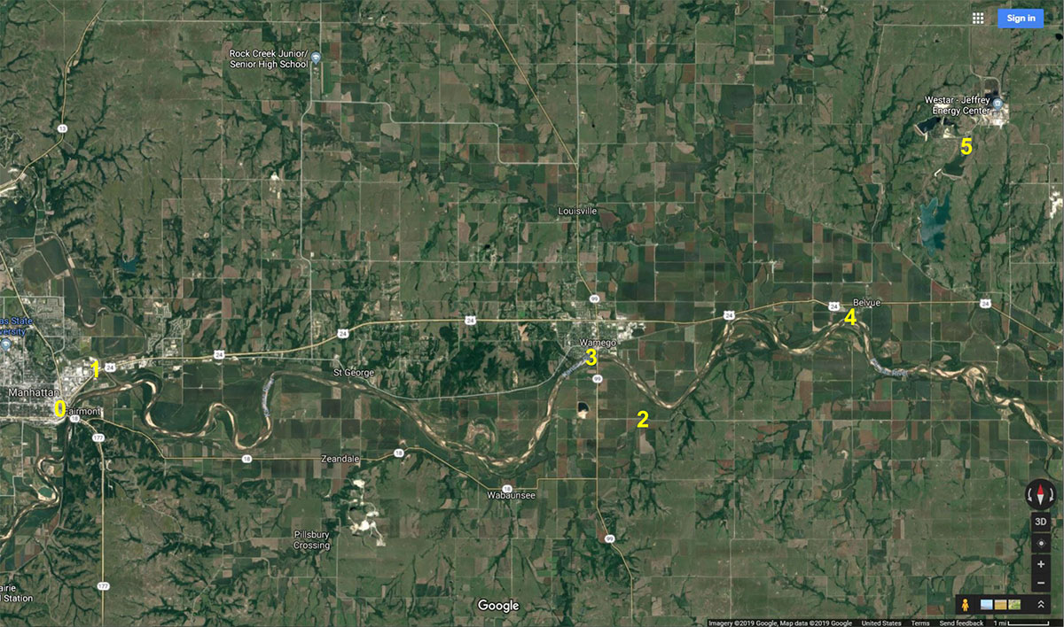
Overview of field trip route along the Kansas River corridor. The trip starts in Manhattan. Stop 1 is in the City of Manhattan well field next to the Big Blue River east of Manhattan. Stop 2 is a KGS real-time water-level monitoring well southeast of Wamego. Stop 3 is a rest stop at a Wamego park next to the Kansas River. Stop 4 is the Jeffrey Energy Center water intake facility next to the Kansas River southwest of Belvue. Stop 5 is the constructed wetlands southwest of the Energy Center.
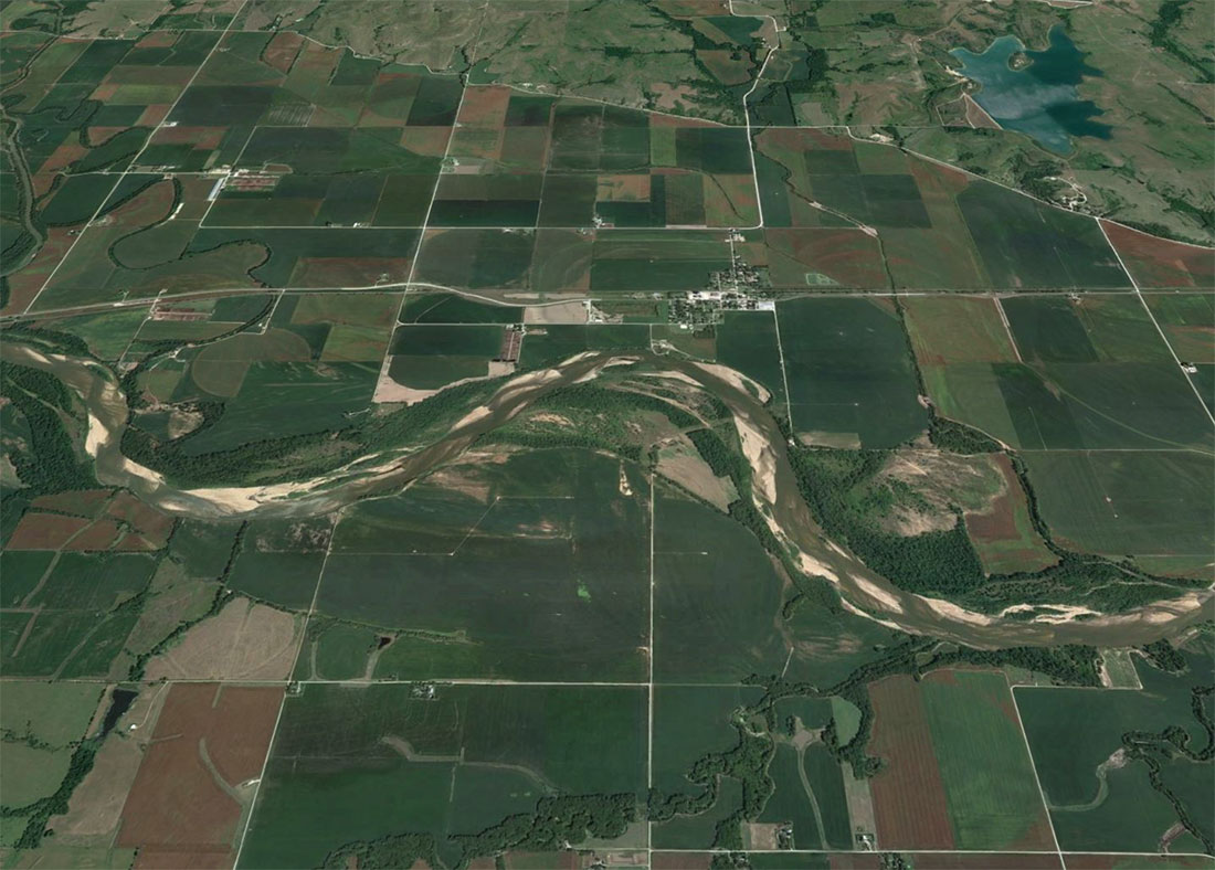
The main part of the Kansas River extends through northeast Kansas from Manhattan to Kansas City, where it joins the Missouri River (figure 1). Surface water from the Kansas River and groundwater from the alluvial aquifer system in the river valley provide most of the water supply for all uses within and adjacent to the river corridor. The Quaternary alluvial deposits that fill the bedrock valley range to more than 80 ft in the deepest buried channels under terrace deposits occurring along parts of the sides of the river valley. The bedrock is from Pennsylvanian to Permian age and consists primarily of limestone and shale, although some short sections of the valley are underlain by sandstone. The sediment in the lower part of the main alluvial aquifer is generally coarse (arkosic sand and gravel) and is overlain by finer-grained deposits (sand, silt, and silty clay). The sediment in the lower deposits below some terrace deposits is sand to fine gravel (Davis and Carlson, 1952; Dufford, 1958; O'Connor, 1960, 1971). Depths to the water table in the river valley range from near surface to 50 ft below land surface. Where the alluvial deposits are of substantial thickness, the aquifer has a high transmissivity and can commonly yield more than 1,000 gpm to large-capacity vertical wells (Fader, 1974). The quality of the water is fresh, although it is hard due to groundwater flow passing through the calcareous bedrock underlying the aquifer and in the valley walls. High iron and manganese occur in some portions of the alluvium as a result of chemically reducing conditions probably generated by organic matter in sediment in buried meander cutoffs and overbank deposits (Whittemore et al., 2014).
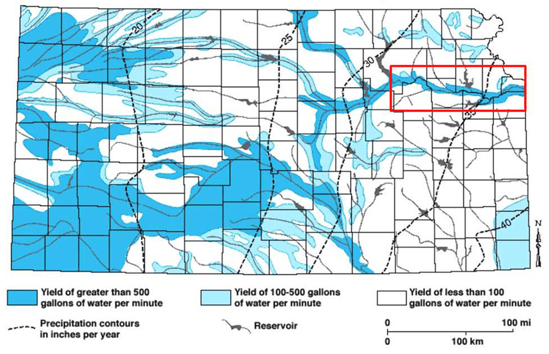
Figure 1—General availability of groundwater and annual precipitation in Kansas (Kansas Geological Survey Special Map 9, generalized from Map M-4A, Kansas Geological Survey, 1975).
Groundwater from the alluvial aquifer of the Kansas River valley supplies a substantial portion of the total water supply for municipal, irrigation, industrial, and other uses in the counties along its extent. Additional development might be considered along edges of the aquifer system away from the river but only in locations where the saturated thickness and permeable sediment are great enough to sustain high-yield wells. A substantial distance between new well locations and the river should minimize the effect of groundwater-level declines on lowering river-water levels during periods of severe droughts. Development in an area where major tributaries enter the river valley would take advantage of tributary recharge. During wet periods, recharge of the alluvial aquifer along the edge of the valley wall and geomorphic terraces, over the terrace and floodplain expanse, and by bank storage from the Kansas River and tributaries would all work to restore water levels (Whittemore et al., 2014).
Decreasing reservoir storage caused by sedimentation could result in lower river water levels during drought because less water would be available for release, which, in turn, could affect the river water intakes of the large capacity users of river water. The location of possible future wells that induce river water infiltration and could potentially decrease water levels in the river will need to be considered relative to the location of river water intakes. The loss of storage capacity within the reservoirs could possibly be offset by managing groundwater storage in the alluvial aquifer. Overall, it would be appropriate to examine storage losses in reservoirs and storage management in the alluvial aquifer system in concert. This would be part of managing the surface water and groundwater as a single resource.
The Kansas Geological Survey (KGS) has proposed construction of a stream-aquifer model of the Kansas River alluvial aquifer from Manhattan to its junction with the Missouri River to determine whether the alluvial aquifer can sustain substantial additional development without significantly affecting water levels both in the river and in the connected alluvial aquifer. The model could be used to assess in which part of the alluvial aquifer future development would have the least influences on river flow. It also could be used to determine the effect of different management plans and how they relate to future decreases in reservoir storage as sedimentation continues as well as to determine the influence of climate change.
Read the PDF version (10 MB)
Kansas Geological Survey, Geohydrology
Placed online July 8, 2019
Comments to webadmin@kgs.ku.edu
The URL for this page is http://www.kgs.ku.edu/Geophysics/OFR/2019/OFR19_18/index.html