D. O. Whittemore, M. A. Townsend, B. S. Sorensen, D. P. Young and J. A. Schloss
Boldface items are linked to other sections; italic items are linked to glossary definitions
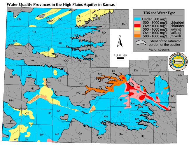
Definitions: The regional groundwater quality provinces are areas in the High Plains aquifer where the groundwater has different ranges in the salinity or total dissolved solids (TDS) concentration and consists of different chemical types. The TDS concentration intervals range from fresh to saline water. The chemical type provinces are based on the predominant chemical character of the ground water, i.e., the major dissolved constituents composing the total dissolved solids, specifically, chloride and sulfate for the province map.
Relevance to understanding water resources: The salinity of water is an important characteristic that determines its uses. Low salinities are generally desirable for all types of water use, including public supply, domestic, agricultural (both stock and irrigation), and industrial uses. In some cases, the particular constituents (such as chloride, sulfate, and the relative amounts of sodium to calcium and magnesium) can be a consideration for use where dissolved solids concentrations are high. The recommended or secondary standard of the U.S.Environmental Protection Agency (EPA) and the Kansas Department of Health and Environment (KDHE) for TDS in drinking waters is 500 mg/L, and for both chloride and sulfate concentrations is 250 mg/L. The general classification limit between freshwater and saline water is 1,000 mg/L.
![]() Map of Groundwater Quality Provinces
Map of Groundwater Quality Provinces
Discussion: The map shows the distribution of TDS concentration in the groundwaters of the High Plains aquifer. The lowest TDS contour interval has an upper value of 500 mg/L, which is the secondary standard for drinking waters. The amount of data and the areas for waters with >1,000 mg/L are relatively small in comparison with those for less saline and freshwater. The TDS concentration of groundwater varies substantially with depth at some locations in the High Plains aquifer. Except for the upper Arkansas River valley, the TDS generally increases with depth in the map areas showing high concentrations. The TDS data reflect the estimated concentration in the main portion of the aquifer.
Most of the ground water in the High Plains aquifer contains TDS concentrations less than 1,000 mg/L indicating that the water is fresh. A large portion of the freshwater has TDS contents less than 500 mg/L. Most of this water is of calcium-bicarbonate type. Aquifer areas with high TDS concentrations include the eastern part of the "Great Bend Prairie" (Groundwater Management District No. 5) and the western portion of the "Equus Beds" area (Groundwater Management District No. 2). The source of salinity in this area is natural intrusion of saltwater (sodium-chloride type water) from Permian bedrock underlying the High Plains aquifer. Ground waters in other areas also have elevated TDS content from intrusion of mineralized water from bedrock underlying the High Plains aquifer. Groundwater in the upper Arkansas River corridor in southwest Kansas has high TDS concentrations from recharge of saline river water that flows into Kansas from Colorado. The water is of sodium-sulfate type that has been largely generated by concentration of natural salts in residual water left after evapotranspiration losses in ditch irrigation systems. Natural evapotranspiration has produced elevated TDS ground waters of sodium-sulfate type in the High Plains aquifer in part of southern Scott and northwestern Finney counties.
Data sources and methods: The water-quality province map is based on water samples collected from the aquifer over the last 30 years (from 1970 to the present). A large portion of the data is from the study of irrigation water quality conducted by the KGS during 1974-1980 and published in KGS Chemical Quality Series Numbers. 2, 4, 6-8, 10, and 11. Other data sets are KGS analyses of more recent samples of irrigation water collected by the KDA, chemical analyses in the QWdata database of the USGS, and chemical data in the STORET database of the U.S. EPA from the present KDHE and past USGS sampling and analysis programs for monitoring groundwaters. Where there are multiple samples for the same site, only the most recent data were used. Only the records in the QWdata database with geologic codes present for units within the High Plains aquifer were used. Data for samples from the alluvial aquifer in Kearny, Finney, Gray, and Ford counties were not used to avoid confusion from the essentially two-aquifer system of the alluvial aquifer perched above the main part of the High Plains aquifer.
The TDS concentrations used to determine the water-quality provinces are primarily calculations of the sum of the major dissolved constituents, although some values are for measurement of the weight of salts remaining after a known volume of water was evaporated to dryness. When calculating the TDS sum, the bicarbonate concentration is multiplied by 0.4917 to represent the amount of carbonate that would be present in the mineral mass left if water were evaporated to dryness.
Qualifications: (uncertainties, data needs, etc.) The map is a generalized representation of the TDS concentration of the aquifer. It is not intended to show the detail of all high TDS locations in the aquifer. Contours are not drawn on the map for an isolated well with a greater TDS content than the surrounding area. Therefore, the map does not show contamination sites of local extent, although it does represent larger areas of substantial contamination such as by infiltration of saline Arkansas River water. One of the largest uncertainties inherent in displaying water-quality data in a single map for an aquifer is the great range in quality with depth. As indicated above, the map represents the main portion of the High Plains aquifer from which larger capacity wells draw water. In some cases, for example, in parts of the Great Bend Prairie, the areas on the map represent an average between TDS data for both the shallow and deep aquifers. Although data exist for TDS concentrations with depth for selected portions of the aquifer, the data are too limited to illustrate depth differences across the entire aquifer. Another uncertainty is the limited amount of data available for a shorter, recent time interval for the entire aquifer. Therefore, the last 30 years of data were used because it is more important to have points in areas that would otherwise have no data than to have points for a shorter time span with large spatial gaps of no information. Much of these data are for the period 1974-1980. Although many of the high TDS areas have natural sources, temporal changes are occurring in some areas impacted by human actions such as salt mining, oil production, irrigation, and waste disposal. This points to a need for more widely distributed sampling over a period of less than a decade.
Next section: Estimated Annual Groundwater Recharge
Back to Directory
Funded (in part) by the Kansas Water Plan Fund