![]()
Prev Page--Permian, Cretaceous, and Tertiary Systems || Next Page--Well Records
Geologic Formations and Their Water-bearing Properties, continued
Quaternary System
Pleistocene Series
Meade Formation
The Meade formation was recognized by Cragin (1896, p. 53) as the Meade gravels which was the name proposed by him for the lowest of three "terranes" in the vicinity of the old Vanhem post office in sec. 13, T. 30 S., R. 23 W., Clark County (Hibbard, 1944b, p. 709). Cragin also gave the name Pearlette ash to the deposits of volcanic ash in that region. Smith (1940, pp. 100-111) assigned the names Odee formation, Equus niobrarensis beds, and Jones Ranch beds to Pleistocene deposits in Meade County and adjacent areas. The Meade formation was redefined by Frye and Hibbard (1941, PP. 411-419) to include Cragin's Meade gravels and Pearlette ash, Smith's Odee formation, Equus niobrarensis beds, and Jones Ranch beds, and all other beds of Pleistocene age above the Rexroad and below the Kingsdown silt. Additional paleontologic studies by Hibbard* indicate that the Jones Ranch beds are equivalent to a part of the Kingsdown silt and therefore should not be considered a part of the Meade formation.
Character--The uppermost beds of the Meade formation do not crop out in Seward County. The Odee formation and Equus niobrarensis beds are local deposits that apparently were laid down in sink holes and therefore do not extend into Seward County. The Meade formation as exposed in Seward County (called the lower Meade by Frye and Hibbard) is very nearly an exact duplication of the Rexroad (?) formation. It consists of a deposit of coarse sand and gravel at the base, a zone of transition in the middle consisting of poorly sorted silt, sand, and gravel containing abundant nodules and stringers of caliche, and an upper zone consisting of fine sand, silt, clay, and beds of caliche (Pl. 7). Volcanic ash is found in a few places in the upper zone. Measured sections of the Meade formation are given on the following pages:
| Section of Meade formation in sec. 21, T. 83 S., R. 28 W., Meade County, Kansas (Frye, 1942, p. 98) | Thickness (feet) |
||
|---|---|---|---|
| Quaternary--Pleistocene | |||
| Meade formation | |||
| 18. Silt, sand, and some clay; tan to buff brown, massive; contains sandy beds and caliche cobbles | 14.8 | ||
| 17. Sand and silt; gray to gray tan | 5.4 | ||
| 16. Clay with some silt and sand; light gray, massive. Breaks with a conchoidal fracture when dry | 4.5 | ||
| *15. Volcanic ash, pearl gray, lenticular, somewhat impure | 1.6 | ||
| 14. Silt, clay, and some sand; gray, massive; contains a few calcareous nodules. (Borchers fauna, where present, occurs at top of this bed) | 6.4 | ||
| 13. Volcanic ash (Pearlette member), pearl gray, thin-bedded, cross-bedded | 7.1 | ||
| 12. Clay, silt, and some sand; tan gray and brown gray, massive. Grades upward into yellowish gray-green sand and contains some mottled yellow-brown silt. Contains a few thin beds of ash and calcareous nodules. (Cudahy fauna occurs at top of this bed, where present | 9.5 | ||
| 11. Sand, silt, and coarse gravel; brown; contains abundant nodules. Grades upward into red-brown to tan-maroon sand and silt | 8.8 | ||
| 10. Sand, coarse and well sorted at base, grading upward into finer, more poorly sorted sand. Calcareous nodules at top | 10.1 | ||
| Ogallala formation | 78.0 | ||
| Thickness of Meade formation exposed | 68.2 | ||
*This section was examined later by Claude W. Hibbard who was unable to find bed 15 (personal communication).
| Section of Meade formation in secs. 28 and 83, T. 34 S., R. 81 W., Seward County, Kansas | Thickness (feet) |
||
|---|---|---|---|
| Quaternary--Pleistocene | |||
| Meade formation | |||
| 9. Caliche, white. Weathers to coarse rubble | 3 | ||
| 8. Clay, buff and gray; contains fine sand | 12 | ||
| 7. Caliche, crumbly, white, impersistent. Forms ledge in some places | 1 | ||
| 6. Clay, light gray | 6 | ||
| 5. Caliche, white, fairly persistent. Forms ledge | 0.5 | ||
| 4. Clay, gray to greenish gray, fossiliferous | 5 | ||
| 3. Sand, fine to medium; contains gravel at the base | 5 | ||
| 2. Sand, fine, and silt; red; contains numerous nodules and bands of caliche. In many places caliche is very hard and is more resistant to erosion than the silt and clay. In other places the caliche is soft and the rock has a red and white mottled appearance. Forms vertical walls where cut by small streams and gullies. Where caliche is resistant it accumulates in rubble on the surface | 15 | ||
| 1. Sand and gravel, coarse; contains "mortar beds" about 20 feet below the top. Base not exposed | 30 | ||
| Thickness of Meade formation exposed | 77.5 | ||
| Section of Quaternary and Tertiary deposits in NW 1/4 sec. 85, T. 33 S., R. 32 W., Seward County, Kansas. (Measured by Claude Hibbard and John C. Frye.) | Thickness (feet) |
||
|---|---|---|---|
| Quaternary--Pleistocene | |||
| Terrace deposit | |||
| 10. Sand and gravel, coarse, poorly sorted. Pebbles consist of granite, felsite, vesicular basalt, quartzite, sandstone, and chert. Pebbles are as large as 7 inches in largest diameter | 12 | ||
| Meade formation | |||
| 9. Volcanic ash interbedded with light-tan silty clay and firm-grained sand | 10 | ||
| 8. Sand, fine to coarse, and silt; pale buff | 5 | ||
| 7. Silt and clay, thin-bedded | 2.1 | ||
| 6. Sand and gravel, grading upward into medium sand | 8 | ||
| 5. Sand and gravel cemented with calcium carbonate to form "mortar bed" | 1.2 | ||
| 4. Sand and gravel, cross-bedded. Pebbles are as large as 2 inches in diameter | 3.3 | ||
| disconformity | |||
| Tertiary--Pliocene | |||
| Rexroad (?) formation | |||
| 3. Sand and silt, poorly sorted, tan and dirty pink; contains nodules and bands of caliche | 5.2 | ||
| 2. Silt and clay, gray and tan; contains bands of nodular caliche. Massive zone of caliche at the top | 2.6 | ||
| 1. Sand, silty, buff tan to gray | 8.1 | ||
| Thickness of Meade formation exposed | 29.6 | ||
| Thickness of Rexroad (?) formation exposed | 15.9 | ||
The basal deposit of sand and gravel in the Meade formation consists primarily of material derived from igneous rocks but may also contain many water-worn pebbles of caliche and "mortar beds" derived from older sedimentary rocks. The sand and gravel generally is cross-bedded and the individual beds are moderately well sorted. A part of the deposit generally is cemented with calcium carbonate to form "mortar beds" which erode to prominent ledges in many places along Cimarron Valley and which form the cap rock of several buttes in Cimarron Valley near the Meade-Seward County line.
The sand and gravel of the Meade formation generally is coarser than the sand and gravel at the base of the Rexroad (?) formation. It contains a greater abundance of water-worn pebbles of caliche and "mortar beds" and appears to contain more chalcedony. The sand and gravel of the Meade formation differs markedly from that of the Ogallala formation. The Ogallala formation in Meade and Clark Counties contains abundant pebbles of fine-grained sandstone, gray quartzite,. and ironstone which probably were derived from the Dakota formation and other Cretaceous deposits (Smith, 1940, p. 42). Pebbles of this type are rare in the Meade formation. In addition, the Ogallala formation contains relatively few water- worn pebbles of caliche and "mortar beds."
The middle or transition zone of the Meade formation consists of poorly sorted reddish silt, sand, and gravel containing abundant nodules and stringers of caliche (Pl. 10). The material is moderately well indurated and forms steep slopes in some places. The caliche generally is harder than the rest of the material, forming a rough surface on steep slopes and abundant rubble on gentle slopes. The gravel becomes more abundant near the base and generally is absent in the upper part. The zone has a characteristic mottled red and white appearance. This deposit is well exposed in many places along Cimarron Valley from northwestern Stevens County to central Meade County. It is particularly well exposed in the railroad cut north of the Arkalon railroad bridge.
The upper part of the Meade formation in Seward County consists of beds of clay, silt, fine sand, and caliche containing volcanic ash in some places (Pl. 11A). Locally there is a few feet of sand and gravel at the base. This sand and gravel thickens eastward and is widespread in Meade County (Claude W. Hibbard, personal communication). The silt and clay generally is light gray to greenish gray but may be light brown, brown, buff, or pinkish buff. The caliche occurs in beds ranging in thickness from a few inches to nearly 4 feet. The uppermost bed generally is thickest and has been quarried in a few places for road metal. The volcanic ash crops out in many places in Meade County but has been found in only a few isolated places in Seward County. Its occurrence has been described in more detail under mineral resources.
Distribution and thickness--The Meade formation is widespread in southwestern Kansas. It underlies most of the area in Kansas south of the Arkansas River and west of Meade. It has also been observed in the panhandle of Oklahoma. The formation was deposited over all of Seward County and is absent only where Cimarron River has eroded down to the underlying formations. In most of Seward County it is underlain by the Rexroad (?) formation and overlain by the Kingsdown silt or by dune sand.
The thickness of the Meade formation is variable depending primarily upon the thickness of the basal sand and gravel (Pl. 7). The measured thickness at the type locality (measured section on page 78) is approximately 68 feet but at this point the basal sand and gravel are very thin. Its average thickness in Seward County probably is between 75 and 100 feet. Toward the west the basal sand and gravel seems to thicken whereas some of the upper beds pinch out or have been removed by erosion.
Water supply--The Meade formation yields water to a part of the wells in the western half of Seward County. In Cimarron Valley in the western half of Seward County the contact of the Meade and Rexroad formations is approximately at the level of the stream which represents approximately the level, of the water table in adjacent upland areas. Most of the Meade formation, therefore, lies above the water table but the lowermost part of the formation may be saturated with water and may yield water to wells. Wells in western Seward County probably obtain most of their water from the Rexroad (?) formation but many may obtain part of their water from the Meade formation. Few, if any, wells obtain water from the Meade formation in the eastern half of Seward County.
Pleistocene and Recent Series
Kingsdown silt
The Kingsdown marl was described by Cragin (1896, p. 54) from outcrops southwest of Kingsdown in Ford County and along Bluff Creek in northern Clark County. He did not designate a type locality for these beds but they are typically exposed in the vicinity of the old Vanhem post office in sec. 13, T. 30 S., R. 23 W., Clark County. Cragin believed that the Kingsdown marl might be Pliocene. These deposits were redefined as the Kingsdown formation by Smith (1940, pp. 111-116) who designated as the type locality an outcrop that he measured in sec. 13, T. 30 S., R. 23 W., Clark County. Frye and Hibbard (1941, pp. 419-420) redefined these beds as the Kingsdown silt and included the overlying loess of uppermost Pleistocene and Recent age. Hibbard (1944b, pp. 745-752 has recognized two phases of the Kingsdown silt in Clark County which he has called lower and upper Kingsdown. The Kingsdown silt exposed in Seward County probably is equivalent to the upper Kingsdown as defined by Hibbard.
Character--The Kingsdown silt in Seward County consists of fine sand in the lower part grading upward into sandy silt, silt, and loess. The upper part may contain many small nodules of caliche The lower sand is thin-bedded and the upper silt and loess are massive and have been eroded to form vertical cliffs in some places. These beds range from light tan to buff.
Distribution and thickness--The Kingsdown silt underlies mud of southwestern Kansas. It covers much of Grant, Haskell, Meade Clark, and Ford Counties and the northern part of Seward County These beds are thin or absent south of Cimarron River in Seward County where the Meade formation is at the surface or is overlain by dune sand.
The Kingsdown silt is thickest in northern and northeastern Seward County. The thickness ranges from a featheredge near Cimarron River to approximately 40 feet in the northeastern part of the county.
Water supply--The Kingsdown silt lies above the water table in Seward County; hence it does not yield water to wells. The lower part of the formation is saturated with water in a few places in Meade County where it yields small quantities of water to a few wells (Frye, 1942, P. 110).
Terrace deposits
There are at least two and possibly three terraces along Cimarron River in southwestern Kansas (Smith, 1940, pp. 126, 153; Frye and Hibbard, 1941, p. 420; and McLaughlin, 1946, pp. 132-134). The most prominent terrace is about 50 feet below the level of the upland which in southeastern Seward and southwestern Meade Counties is more than 200 feet above the level of the stream. The terrace generally is level with the top of the red transition zone in the Meade formation and the underlying sand and gravel generally lie in channels in the basal sand and gravel of the Meade formation. The sand and gravel underlying the highest terrace includes abundant cobbles of sandstone apparently derived from Mesozoic rocks, and cobbles of reddish light vescicular basalt probably derived from the beds of lava along the headwaters of Cimarron River.
A second terrace which is about 50 to 75 feet above the level of the stream has been observed in southeastern Seward County and southwestern Meade County. The sand and gravel underlying this terrace mantles the hills formed by the tilted strata of the Laverne formation.
A third terrace at a level of about 20 feet above the stream bed was noted in Stevens and Seward Counties by Smith (1940, pp. 126 and 153) and in Morton County by McLaughlin (1946, pp. 132-133). This terrace is not well preserved in most of Seward County owing to the mask of colluvium that covers the lower valley slopes.
Frye and Hibbard (1941, p. 420) report that teeth of Paraelephas columbi (Falconer) have been taken from the high-terrace deposits in Cimarron Valley south of Meade The remains of fossils and the fact that the highest terrace deposits are in channels cut into the Meade formation indicate that this terrace was formed during late Pleistocene time and therefore that almost all the downcutting in Cimarron Valley was during late Pleistocene and Recent time. The terrace deposits lie above the water table in Seward County and do not yield water to wells.
Recent Series
Alluvium
Alluvium occurs only along the floor of Cimarron Valley in Seward County (Pl. 1). It consists primarily of sand and gravel containing lesser amounts of silt and clay. The thickness of the formation in Seward County is not known but test holes drilled through the alluvium in adjacent areas indicate a thickness of about 70 feet.
The alluvium in Seward County has been covered in many places by recent pediment-like deposits and in other places has been partly removed by the widening channel of Cimarron River. As a result, very little bottom land remains and the broad sandy channel of Cimarron River occupies most of the valley floor.
Alluvium yields water to many domestic and stock wells in Cimarron Valley, but the yield of these wells generally is small. Water in the alluvium generally is hard but can be used for most domestic and farm purposes (see analyses 22, 53, 100, and 102).
Dune Sand
Most of the area south of Cimarron River and part of the area north of Cimarron River is underlain by dune sand (Pl. 1). It overlies the Meade formation south of the river and the Meade and Kingsdown formations north of the river. In the northwestern part of the county it extends into Cimarron Valley and is in contact with the alluvium. The sand consists of fine- to medium-grained well rounded quartz sand containing some silt.
Smith (1940, pp. 159-165) described an ideal dune cycle in his discussion of sand dunes in southwestern Kansas. The cycle consists of two phases: (1) An eolian or active phase during which the dune is built up, and (2) an eluvial or passive phase during which vegetation prevents further growth and the dune is subdued by weathering and creep. He divides the eluvial phase into stages of youth, maturity, and old age. In the youth stage, the soil zone is formed and slopes are reduced. The dune becomes mature when its profile is smooth and regular and when its soil becomes thicker and more stable. Old age is reached when the dune form is indistinguishable. He states that the eluvial phase in any stage may be interrupted by rejuvenation. These stages account for the varied topography discussed on pages 14 and 36.
The thickness of the dune sand may be as much as 40 or 50 feet where the dunes are still in the youthful stage but it is relatively thin between the higher dunes and in areas where the dunes have reached the old-age stage of the erosion cycle.
Most of the dune sand probably is of Recent age because it was deposited over the terraces and the alluvium which are late Pleistocene to Recent. Some of the dune sand in Seward County, however, appears to be much older (Pl. 9A). In the railroad cut southwest of Kismet there is a deposit of moderately well indurated dune sand that is separated from overlying younger less consolidated dune sand by a well defined soil zone. The older dune sand may be Pleistocene.
The dune sand lies wholly above the water table in Seward County and does not yield water to wells. The dune-sand areas are poorly drained and form ideal catchment areas which assist in the recharge of the ground-water reservoir.
Colluvium
(Term applied to heterogeneous aggregates of rock detritus, such as talus and avalanches, resulting from the transporting action of gravity.)
Frye and Smith (1942, pp. 215-221) reported pediment-like slopes along Smoky Hill River in Logan and Gove Counties and along Cimarron River in southeastern Seward County. These slopes are particularly well developed in Cimarron Valley between the highway bridge north of Liberal and the Forgan bridge in southwestern Meade County. The pediment-like slopes in this area are in part mantled with alluvial detritus or colluvium, consisting of a poorly sorted admixture of sand, gravel, silt, and clay. The deposits are composed of material derived from the Meade and Rexroad (?) formations which form the valley walls.
Character--The colluvium in most places consists primarily of sand and gravel containing silt and clay, but in a few places the finer materials are predominant. The larger pebbles may be fragments of igneous rocks derived from the basal sand and gravel of either the Meade or the Rexroad (?) formation or they may be rough fragments of caliche, "mortar beds," siltstone, or clay derived from the middle and upper parts of these formations. The deposits generally are structureless, display no sorting, and are slightly indurated. The silt and clay bind the pebbles so that the deposit erodes to a vertical bluff in a few places. Soil zones were observed in these deposits near the highway bridge north of Liberal.
Since 1914 the channel of Cimarron River has been widening rapidly and apparently has also lowered. This has caused recent accelerated erosion in the tributary streams that traverse the colluvium. The surface of the colluvium, therefore, is very irregular and the land underlain by it generally is unsuitable for any use other than grazing.
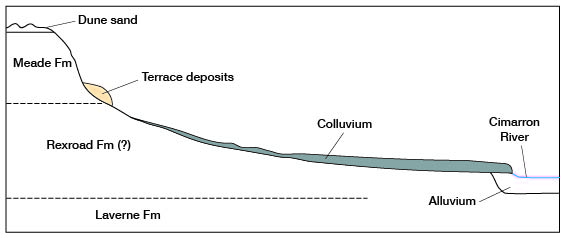
Distribution and thickness--The colluvium mantles much of the lower slopes in Cimarron Valley throughout Seward County (Pl. 12). As stated above, it is most widespread in the southeastern part of the county where it generally extends from a point at or near the channel of the river almost up to the high terrace deposits. The material ranges in thickness from a featheredge near the edge of the valley to approximately 30 feet in some places near the river. The idealized transverse section of Cimarron Valley shown in Figure 10 illustrates the mode of occurrence of the colluvium.
Figure 10--Diagrammatic profile of Cimarron Valley in southeastern Seward County.
Water supply--The colluvium lies above the water table; hence it does not yield water to wells in Seward County.
Prev Page--Permian, Cretaceous, and Tertiary Systems || Next Page--Well Records
Kansas Geological Survey, Geohydrology
Web version Sept. 2001. Original publication date March 1948.
Comments to webadmin@kgs.ku.edu
The URL for this page is http://www.kgs.ku.edu/General/Geology/Seward/06_gf4.html