![]()
Prev Page--Geology || Next Page--Recharge, Discharge, Recovery
Ground Water
Principles of Occurrence
This discussion of the principles governing the occurrence of ground water takes account of conditions in Seward County. Preparation of the discussion has been based chiefly on the authoritative and detailed treatment of the occurrence of ground water by Meinzer (1923), to which the reader is referred for more extended consideration. A general discussion of the principles of groundwater occurrence, with special reference to Kansas, has been published by Moore (1940).
The rocks that make up the outer crust of the earth generally are not entirely solid, but have numerous openings, called voids or interstices, which may contain air, natural gas, oil, or water. The number, size, shape, and arrangement of the interstices in rocks depend upon the character of the rocks. The occurrence of water in any region is therefore determined by the geology.
The interstices or voids in rocks range in size from microscopic openings to the huge caverns found in some limestones. The open spaces generally are connected so that water may percolate from one to another, but in some rocks these open spaces are isolated and the water has little chance to percolate. In Seward County, the rocks from which most of the ground water is obtained are poorly consolidated sand and gravel. Generally the sand and gravel of the Tertiary and Quaternary deposits contain many interstices through which water percolates freely; locally these interstices may be filled with calcium carbonate, clay, or other materials that make the rock relatively impermeable; Much of the silt, sand, and gravel of the Tertiary and Pleistocene deposits is poorly sorted and the finer particles fill a part of the space between the larger particles, thereby decreasing the amount of space available to ground water. The sandstones of the Dakota formation are cemented with iron oxide or calcium carbonate. The cement occupies a part of the spaces between sand grains, but enough voids are left to contain some water.
The porosity of a rock is the percentage of the total volume of the rock that is occupied by interstices. A rock is said to be saturated when all its interstices are filled with water or other liquid and the porosity is then practically the percentage of the total volume of rock that is occupied by water. The porosity of a rock determines only the amount of water a given rock can hold, not the amount it may yield to wells. Some rocks may be highly porous, but will not yield an appreciable amount of water to. a well. The specific yield of a water-bearing formation is defined as the ratio of (1) the volume of water which, after being saturated, it will yield by gravity to (2) its own volume. It is a measure of the yield when it is drained by a lowering of the water table. The permeability of a water-bearing material is defined as its capacity for transmitting water under hydraulic head, and is measured by the rate at which it will transmit water through a given cross section under a given difference of head per unit of distance. A rock containing very small interstices may be very porous, but it would not be very permeable, whereas a coarser-grained rock, although it may have less porosity, generally is much more permeable. Some water is held in rocks by the force of molecular attraction, which, in fine-grained rocks, is sufficiently great to make the rock relatively impermeable.
Below a certain level in the earth's crust, the permeable rocks generally are saturated with water and are said to be in the zone of saturation. The upper surface of the zone of saturation is called the groundwater table, or simply the water table. All the rocks above the water table are in the zone of aeration, which ordinarily consists of three parts: the belt of soil water; the intermediate or vadose zone; and the capillary fringe.
Artesian Conditions
The head of water may be defined as the height that a column of water will rise in a tightly cased well that has no discharge. Ground water that rises in wells above the level at which it is first encountered is said to be artesion or "piestic" water (Meinzer and Wenzel, 1942, p. 451).
In some rock formations, relatively permeable strata such as sand and gravel alternate with relatively impermeable strata such as clay or shale. If these beds have a slope, then water that falls on the area of outcrop of a permeable bed moves down the dip of the bed between the confining layers of relatively impermeable material and saturates the permeable stratum. Wells drilled to the saturated bed encounter water under artesian head. Artesian water has been encountered in many wells in Seward County but nowhere in this area has the artesian head been sufficient to cause them to flow.
The Water Table
The water table, defined above as the upper surface of the zone of saturation, is not a static level surface, but rather it generally is a sloping surface that may exhibit hills and valleys similar to those of the land surface. Figure 6 demonstrates diagrammatically some general relationships of the water table to the land surface and to bodies of surface water. Other irregularities may be caused by differences in permeability of water-bearing materials or by unequal additions of water to the groundwater reservoir at different places.
Figure 6--Diagram showing the relation of the water table to the land surface and to bodies of surface water.
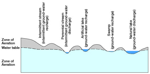
Water in the zone of aeration, once it has penetrated below the soil zone, seeps vertically downward until it reaches the zone of saturation, unless it encounters an inclined layer of relatively impermeable rock. Within the zone of saturation the direction in which the water moves is determined by the hydraulic gradient, and generally is toward streams or lakes or areas of lower altitude. In some places the usual direction of percolation may be reversed, as in the vicinity of a stream that is losing water to the materials over which it is flowing or in the vicinity of an artificial lake in which the water level has been raised above the local water table.
The rate at which groundwater percolates is relatively slow as compared with the velocity of water in surface streams. The frictional resistance encountered by ground water as it percolates through the interstices of the rocks is far greater than that created by surface water as it flows over the land. Hydrostatic head and permeability are the important factors determining groundwater velocity.
Shape and Slope
The shape and slope of the water table in Seward County are shown on the map (Pl. 1) by contour lines drawn on the water table. All points on the water table on a given contour line have the same altitude. These water table contours show the configuration of the water surface just as topographic contour lines show the shape of the land surface. The direction of movement of the ground water is at right angles to the contour lines in the direction of the downward slope.
The map (Pl. 1) shows that the general movement of the ground water in Seward County is east-southeastward, but that the slope and the direction of movement of the ground water vary considerably from one part of the county to the other. The maximum slope is in the area of closely-spaced contours in the southwestern part of the county and is nearly 40 feet to the mile, whereas the minimum slope is in the northeastern corner of the county and is about 4 feet to the mile. The average slope along the north line of the county is 5.5 feet to the mile and the average slope along the south line of the county is 16.7 feet to the mile.
The shape and slope of the water table, which determine the rate and direction of movement of ground water, are controlled by several factors. Irregularities in the shape and slope of the water table in Seward County appear to be caused by: (1) the shape and slope of the underlying bedrock floor; (2) discharge of ground water into streams; (3) recharge of the groundwater reservoir by ephemeral streams; and (4) local differences in the permeability of the water-bearing materials. The effect of these factors on the shape and slope of the water table will be discussed separately in the following paragraphs.
The shape and slope of the bedrock floor (the Dakota formation and the Permian redbeds) probably have little or no effect on the configuration of the water table but probably are among the chief factors affecting the general slope of the water table. The slope of the water table in Seward County and in adjacent areas is approximately in the same direction and degree as that of the bedrock floor.
The discharge of ground water into streams is one of the principal factors affecting the shape and slope of the water table in Seward County. Below the point where the 2,710-fool contour line crosses Cimarron River (Pl. 1) the channel of the river has been cut lower than the water table in areas adjacent to the river. The ground water moves toward the river from adjacent areas and discharges into the Cimarron Valley causing a depression of the water table which is indicated by the upstream flexure of the water-table contours. The relation of the water to the stream channel is shown in Figure 6. The greatest upstream flexure of the contours is in the southeastern corner of the county. The flexure diminishes in degree upstream as the difference between the levels of the stream channel and the adjacent water table diminish.
The recharge of the ground water by an ephemeral stream has caused a slight downstream flexure of the water-table contours in the northwest corner of the county. The channel of the river in this area is above the level of the water table, hence water moves downward through the stream bed to create a ridge in the water table.
Local differences in permeability of the water-bearing materials probably is the principal factor causing the steep slope of the water table in the western part of the county. This zone of closely spaced contours extends northwestward through northeastern Stevens County and southeastern Grant County. On both sides of this zone the water table is relatively flat. In the zone of closely-spaced contours the upper part of the zone of saturation probably is in relatively impermeable silt and clay whereas on either side it probably is in more permeable deposits of sand and gravel.
Relation to Topography
Plate 2 shows the relation of the water table to the land surface in Seward County by means of isobath lines which are lines of equal depth to water level. All points on the 50-foot isobath, for example, are points at which the water table lies 50 feet below the land surface. In areas between the 50-foot and 100-foot isobaths the depth to water is more than 50 feet but less than 100 feet. In the preparation of this map an effort was made to take into account the major irregularities of the land surface.
For purposes of detailed descriptions of the groundwater conditions, Seward County may be divided into several areas based upon the depths to water level: (1) Cimarron Valley area, (2) Liberal area, (3) Kismet area, (4) Hayne area, (5) western area, (6) northwestern area, (7) northeastern area, and (8) southwestern area. A brief description of each area follows.
Cimarron Valley area--The Cimarron Valley area includes the flood plain of Cimarron River and the gentle valley slopes adjacent to the flood plain. The depth to water level is less than 50 feet along the deeper part of the valley and ranges from 50 to 100 feet along two narrow sloping belts that border the valley. The shallowest well in the county (80), which has a depth to water level of only 9.5 feet, is in this valley.
Wells in this area obtain water from the alluvium of Cimarron Valley, the Rexroad (?) and Laverne formations, and possibly also from the sand and gravel of the Meade formation. All of the stock ranches in the county are situated in this area. Most of the wells that supply these ranches are on the flood plain and have water levels within 50 feet of the surface.
In 1940 there was one irrigation well which obtained water from the alluvium in this area. The alluvium is capable of supplying abundant quantities of water for irrigation. The height the water must be lifted to the surface is slight, the topography in some places is suited to irrigation, and the soil in many places is not too sandy. It would seem that a well-water irrigation project would have a better chance for success in this area than in any other part of Seward County.
Liberal area--The Liberal area includes approximately 25 square miles of land immediately to the west of Liberal in which the depth to water level ranges from about 75 feet to 100 feet. The ground water probably is obtained from the lower part of the Meade formation and perhaps in part from the Rexroad (?) formation.
The Liberal deep-well irrigation project, discussed later in some detail, was undertaken just outside this area and was not deemed entirely successful, owing mainly to the large drawdown of the water level in the well during pumping. This increased the height it was necessary to lift the water to the surface and added materially to the cost of operation. It is possible that similar difficulty would be encountered in other parts of this area.
Kismet area--The Kismet area includes the City of Kismet, in which the depth to water level is more than 200 feet. A maximum depth to water level of 212 feet was encountered in well 65 in this area. The water is obtained from the Rexroad (?) or Laverne formation. The area roughly coincides with a belt of fairly high sand dunes.
Hayne area--The Hayne area, in which the water level is more than 200 feet below land surface, is the most extensive of the four deep-water areas in the county and, as is true of the others, it coincides with an area of fairly high sand dunes. Its extent is about 43 square miles. The deepest water level found in the county, 249 feet (well 118), is in this area. The water probably is obtained from the Laverne or Rexroad (?) formation.
Western area--The western area includes only about 5 square miles along the western border of Seward County (secs. 17, 18, and 10, T. 32 S., R. 34 W. and parts of the adjacent sections), in which the depth to water level is more than 200 feet. In well 58 in this area the water table is 215 feet below land surface. The Rexroad (?). formation probably supplies water to most of the wells in this area.
Northern area--The northern area comprises slightly more than 3 square miles in the northwestern part of the county in which the depth to water level is more than 200 feet. It extends northward into Haskell County. The water in this area is obtained primarily from the sand and gravel of the Rexroad (?) formation.
Northeastern area--The northeastern area comprises nearly half the county and almost all of the county north of Cimarron River. In this area, the depth to water level ranges from 100 to 200 feet. From the upper edge of Cimarron Valley the area extends northward into Haskell County and eastward into Meade County. Enclosed within it are the Kismet and the northern deepwater areas. Most of the wells in this area obtain their supplies of water from the Rexroad (?) formation and a few wells probably obtain water from the Meade formation.
Southwestern area--The southwestern area includes all of the area south of Cimarron Valley in which the depth to water level ranges from 100 to 200 feet. The water in this area probably is obtained primarily from the Rexroad (?) formation. The Hayne, western, and Liberal areas lie within this more extensive area.
Fluctuations in Water Level
The water table in any area does not remain stationary but fluctuates up and down much like the water in a surface reservoir. If the inflow to the underground reservoir exceeds the draft, the water table will rise; conversely, if the draft exceeds the inflow, the water table will decline. Thus, the rate and magnitude of fluctuation of the water table depend upon the net rate at which the underground reservoir is replenished or depleted.
The principal factors controlling the rise of the water table in Seward County are the amount of precipitation that passes through the soil and moves downward to the water table the amount of water added to the groundwater reservoir by seepage from Cimarron River, and the amount of water entering the area by subsurface inflow from areas to the west and north. The principal factors controlling the decline of the water table in this area are the amount of water discharged by effluent seepage into Cimarron River, the amount of water lost through transpiration and evaporation where the water table is shallow, the discharge of water through springs, the amount of water pumped from wells, and the amount of water leaving the area by subsurface flow into the areas to the east and south.
Fluctuations of the water table are reflected directly in changes in the water levels in wells. In order to record such changes on a monthly basis, 11 representative wells in Seward County were selected as observation wells. The water levels in these wells were measured in July and August, 1940, during the compilation of the well inventory, were measured by Byrne later in August, 1940, and were measured at monthly intervals thereafter by Richard C. Christy, Woodrow W. Wilson, Allen Graffham, and Howard Palmer. These measurements were tabulated by Meinzer and Wenzel (1943, pp. 146-148; 1944, pp. 167-168; 1945, pp. 150-151).
Table 8--Observation wells in Seward County.
| Well number in this report |
Well number in Water-Supply Paper 938, 946, and 988 |
|---|---|
| 3 | 155 |
| 17 | 165 |
| 23 | 108 |
| 53 | 15 |
| 56 | 106 |
| 64 | 122 |
| 85 | 60 |
| 104 | 66 |
| 112 | 52 |
| 128 | 8 |
| 158 | 159 |
Prev Page--Geologic History || Next Page--Recharge, Discharge, Recovery
Kansas Geological Survey, Geohydrology
Web version Sept. 2001. Original publication date March 1948.
Comments to webadmin@kgs.ku.edu
The URL for this page is http://www.kgs.ku.edu/General/Geology/Seward/05_gw.html