![]()
Prev Page--Geography || Next Page--Summary of Stratigraphy
Geography, continued
Mineral Resources
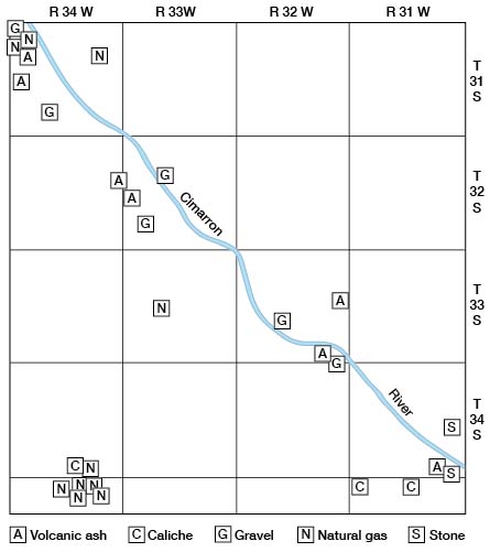
Several mineral deposits of economic value occur in Seward County, including natural gas, volcanic ash, gravel, caliche, and stone. Most of them are produced in relatively small quantities, however, and are used only locally. The locations of these deposits are shown in Figure 5.
Figure 5--Map of Seward County showing locations of mineral deposits.
Gas
Several producing gas wells, gas test wells, and oil test wells have been drilled in Seward County. The logs of several of these are given at the end of this report. The Boles no. 1 well was the first oil test drilled in southwestern Kansas. A strong flow of gas was encountered between depths of 2,716 and 2,755 feet. Deepening the well to 2,919 feet produced only salt water. The well was plugged back to shut out the water and was finished as a gas well on July 20, 1920. This well is the "discovery" well of the southwestern Kansas gas-producing district, generally called the Hugoton field.
The Sealy no. 1 test well which was drilled during 1925 is now capped, but is said to be capable of production. The Pyle no. 1 and Hitch no. 1 test wells were not productive. There were 10 producing gas wells in Seward County at the end of 1944. Landes (1937, p. 88) states, "It is reasonable to assume that all of western Seward County, at least, is underlain by gas-bearing strata." The Liberal Gas Company derives its supply of natural gas from several wells in the vicinity of the discovery well. Production seemingly comes from at least three limestones in the Chase group (Wolfcampian series, Permian system).
Volcanic ash
Volcanic ash, known also as pumice or pumicite, crops out at several localities along Cimarron Valley, mainly along the southwestern side. The material is exposed only on the valley wall generally within 75 feet of the upland surface. Only a few of the deposits were being exploited in 1940. The volcanic ash is found in isolated beds in the Meade formation. The color is roughly determined by the degree of purity, the ash with essentially no extraneous material being white or light gray. The addition of clay alters the color to medium or dark gray. In one locality, some of the ash is brown owing to the addition of limonite. The ash breaks up readily into a fine gritty powder composed of very angular particles. The material shows little or no induration except that imparted to it by the angularity of its constituent particles. The beds, which average about 4 feet in thickness, generally display well-developed bedding, the planes being horizontal in general, but in some places the beds exhibit the oscillatory type of cross-bedding found in materials deposited in lakes or ponds. Irregular calcareous concretions, variable in both size and shape, are a common feature of the ash.
Chemically, the volcanic ash consists predominantly of "rock glass," a solution of solidified silicates, and a minor amount of soda and potash feldspars. No chemical analyses of the ash collected from Seward County were made, but an analysis of a similar deposit found only a few miles to the northwest in Grant County (Western Spar Products Company mine) has been published by Landes (1928, p. 15).
Volcanic ash has many uses. Probably its chief use is as a scouring agent, although such a usage of it is made by only a few residents of the county. There is no commercial production of the Seward County deposits for this purpose at the present time. The pits now being exploited furnish volcanic ash for road-building purposes. The material may be used as a part of the fill of a soft-surfaced road or may be used as a binder in the construction of black-top roads, adding much, it is said, to the ability of such roads to stand up under heavy traffic. Road-building uses are entirely local and only occasional. Following are descriptions of the ash deposits visited by Frank Byrne in 1940.
A small ash pit is located on the west side of the road in the SEl/4 SEl/4 sec. 7, T. 31 S., R. 34 W. The ash is relatively impure and is used only as road fill.
A moderately large pit that seemingly has not been worked for several years is located on the north wall of Yarbo Canyon in the SW 1/4 NE l/4 sec. 19, T. 31 S., R. 34 W. The ash rests on a clay floor and its basal part contains an admixture of clayey impurities. The next 2 feet of material is finely bedded and of greater purity. The top 4 feet comprises a single massive layer that is quite pure except for the uppermost 1.5 feet, which is somewhat clayey. Small tubular concretions are common in the bedded part. The beds appear to dip at an angle of about 15 degrees to the south.
A large pit on the Burg Ranch in the SW 1/4 sec. 19, T. 32 S., R. 33 W. once was extensively worked, the ash having been used in the construction of "black top" roads. The material is in a relatively pure bed about 5 feet thick that becomes clayey near the top. Bedding is well-developed throughout the mass and in one horizon there is strongly marked cross-bedding (Pl. 11B). Large irregular concretionary masses are found throughout the upper part. Soft tan nodules of impure ash as large as 6 inches in diameter occur in a few places. The volcanic ash overlies a massive brown sand.
The Sunflower Mineral Mine in the SW 1/4 NE l/4 sec. 13, T. 33 S., R,. 32 W., is the largest ash pit in the county (Landes, 1928, p. 43). It was opened by T. C. Perry and has not been worked since 1926. The Rock Island Railroad built a short spur to the pit. The floor is a gray clay, above which is a massive bed of relatively pure ash about 8 feet thick. The immediate overburden is a layer of brown sandy volcanic ash containing nodules of caliche. The bedding planes show a low-angle primary dip (Pl. 11C). A textural analysis for this material (given by Landes, 1928, p. 44) indicates that only 7 percent of the material passed through a 300-mesh screen, but that 99 percent of the material passed through a 20-mesh screen.
An outcrop in the NW 1/4 sec. 35, T. 33 S., R. 32 W. contains a bed of relatively pure volcanic ash about 5 feet thick that seems never to have been worked. Gastropod shells were found in the ash.
An unworked outcrop of volcanic ash occurs in the SE 1/4 SE 1/4 sec. 35, T. 34 5., R. 31 W. The bed is about 8 feet thick of which about 4 feet is exposed.
Caliche
Caliche is used within the county as a road-surfacing material. It is applied directly to the top of the road, binding the road gravel firmly, thereby increasing the intervals between gradings. The caliche is taken from shallow pits excavated in the uppermost part of the Meade formation. Pits so used were found at the following localities: (1) three pits in the S l/2 sec. 34, T. 34 S., R. 34 W.; (2) two pits in the NW l/4 sec. 6, T. 35 S., R. 31 W.; and (3) NE 1/4 sec. 3, T. 35 S., R. 31 W. The caliche is disseminated throughout a brown sandy silt or occurs as nodules in the same material. The uncalcified overburden is thin and is easily removed with a drag.
Gravel
Gravel is worked from several localities along Cimarron Valley. All the pits investigated were excavated in the gravelly lower part of the Meade formation or from terrace deposits. These were located as follows:
(1) NW 1/4 sec. 28, T. 31 S., R. 34 W., a very extensive pit operated for gravel and sand for road materials; (2) sec. 17, T. 32 S., R. 33 W., several pits that were worked extensively in 1943; (3) NE 1/4 NW 1/4 sec. 6, T. 31 S., H. 34 W., a fair-sized pit worked for road materials; (4) SW 1/4 NE l/4 sec. 29, T. 32 S., R. 33 W., not now being worked; (5) E 1/2 SE 1/4 sec. 21, T. 33 S., R. 32 W., an extensive pit operated by Mrs. G. A. Correll. The basal 5 feet of gravel is heavily calcified, but the upper 4 feet is clean-washed. The gravel is quite coarse and consists of fragments of sandstone, scoriaceous felsite, graphic granite, petrified wood, mortar bed, and other fragments in less abundance; (6) NW 1/4 SW 1/4 sec. 36, T. 33 S., R. 32 W., a gravel pit operated by the Panhandle Eastern Pipeline Company, about three-quarters the distance up the west wall of Cimarron Valley.
Building stone
Two beds of rock provide building stone for local use. One of these, the so-called "saw-rock" bed in the Laverne formation, was quarried at about the beginning of this century from an exposure of the Laverne in sec. 24, T. 34 S., R. 31 W. The local name refers to the softness of the material which permits the sawing of it into desired shapes and sizes. The rock was used in the construction of some of the buildings at Arkalon and of a few of the ranch buildings in the valley. Despite its softness, the stone seems to be quite durable, perhaps because of the case-hardening of the surface that takes place after the removal of the rock from its natural ledge.
A mortar bed in the Meade formation was quarried in the NE l/4 SE l/4 sec. 36, T. 34 S., R. 31 W. for stone to be used in the construction of the county fair ground at Liberal. The rock is as hard as good limestone and must be quarried by hard-rock methods.
Population
Seward County is one of the less populous of the Kansas counties, ranking 76th in 1940. The census of 1880, the first for the county, lists 5 residents for the county and indicates that they were probably there for the hunting season. In that year, however, there was a post office located at Adobe (sec. 5, T. 34 S., R. 31 W., on the east side of the Cimarron), a settlement since abandoned.
In 1883, the State Legislature added the unorganized counties of Kansas, Stevens, and a portion of Meade, to the unorganized county of Seward. The temporarily enlarged county measured 90 miles east to west and 27 miles north to south. The population was then estimated to be 500. In 1885 the population had increased to 713.
Seward County, in its present size, was formally organized in June 1886, at which time the population had increased to 2,551. Fargo Springs (secs. 25 and 26, T. 32 S., H. 33 W.) was established as the county seat. In 188S, the county seat was removed to Springfield (sec. 4, T. 32 S., R. 33 W.) where it remained until 1896 when it was again removed, this time to Liberal, its present site. The cities of Fargo Springs and Springfield (population of more than 300 persons in 1889) have been abandoned.
The population of the county declined from 2,620 in 1889, to its minimum as an organized unit, 663 in 1897. Then followed a steady increase to 1,493 in 1906, followed by a sudden increase to 3,018 in 1907. The population grew at a fairly constant rate to 5,053 in 1916. Again there came a sudden increase to 6,087 in 1917. Since 1917 the population has fluctuated between 5,990 (1925) and its maximum of 7,768, which was reached in 1939 (Table 5). The population increased greatly during the war as a result of the establishment of an Army air base at Liberal.
Table 5--Population of Seward County, 1880-1940. Compiled from the Biennial Reports of the Kansas State Board of Agriculture.
| Year | Population | Year | Population | |
|---|---|---|---|---|
| 1880 | 5 | 1913 | 4074 | |
| 1881 | not reported |
1914 | 4178 | |
| 1882 | not reported |
1915 | 4498 | |
| 1883 | 500 | 1916 | 5053 | |
| 1884 | not reported |
1917 | 6087 | |
| 1885 | 713 | 1918 | 6006 | |
| 1886 | 2551 | 1919 | 6239 | |
| 1887 | not reported |
1920 | 6327 | |
| 1888 | 2250 | 1921 | 6265 | |
| 1889 | 2620 | 1922 | 6306 | |
| 1890 | 1575 | 1923 | 6203 | |
| 1891 | 1047 | 1924 | 6040 | |
| 1892 | 929 | 1925 | 5990 | |
| 1893 | 1000 | 1926 | 6058 | |
| 1894 | 826 | 1927 | 6191 | |
| 1895 | not reported |
1928 | 6089 | |
| 1896 | 688 | 1929 | 6586 | |
| 1897 | 663 | 1930 | 6954 | |
| 1898 | 685 | 1931 | 6637 | |
| 1899 | 721 | 1932 | 6135 | |
| 1900 | 804 | 1933 | 7318 | |
| 1901 | 865 | 1934 | 6980 | |
| 1902 | 803 | 1935 | 7212 | |
| 1903 | 824 | 1936 | 6816 | |
| 1904 | 978 | 1937 | 7052 | |
| 1905 | 1035 | 1938 | 7061 | |
| 1906 | 1493 | 1939 | 7768 | |
| 1907 | 3018 | 1940 | 6593 | |
| 1908 | 3520 | 1941 | 6448 | |
| 1909 | 3846 | 1942 | 6406 | |
| 1910 | 3858 | 1943 | 8016 | |
| 1911 | 4333 | 1944 | 8004 | |
| 1912 | 4228 |
Of the 1940 population, 90.0 percent were native whites born of native parents, 8.7 percent were native whites born of foreign-born parents, 1.2 percent were foreign-born whites, and 0.1 percent were Negro.
The well-being of agriculture seems to be the determining factor insofar as the county's population is concerned. The sudden increase in population in 1906 and 1907 might possibly reflect the time of the real opening of the southwest to crop agriculture rather than livestock agriculture. The rapid upswing in 1916 and 1917 possibly indicates the influence of World War I on the wheat market and the consequent expansion of the wheat-growing areas in the western part of the State. The recent fluctuations in population seem to be related directly to the crop success or failure for any one year.
Liberal has long been the principal city in the county. At the present time there is only one other incorporated city, Kismet, which was founded in 1930. The distribution of population within the county is shown in Table 6. The percentage of rural inhabitants has declined in recent years, probably because of drought and the subsequent dust storms which made farming an unprofitable enterprise during at least some of the years.
Table 6--Urban and rural populaion of Seward County, 1931-1940. Compiled from the records in the office of the Seward County Clerk.
| Year | Liberal | Kismet | Rural | Total |
|---|---|---|---|---|
| 1931 | 4,099 | 232 | 2,306 | 6,637 |
| 1932 | 3,416 | 244 | 2,475 | 6,135 |
| 1933 | 4,575 | 195 | 2,548 | 7,318 |
| 1934 | 4,314 | 197 | 2,469 | 6980 |
| 1935 | 4,653 | 225 | 2,334 | 7,212 |
| 1936 | 4,509 | 245 | 2,062 | 6,816 |
| 1937 | 4,848 | 237 | 1,967 | 7,052 |
| 1938 | 5,075 | 189 | 1,797 | 7,061 |
| 1,939 | 5,615 | 286 | 1,867 | 7,768 |
| 1,940 | 4,513 | 213 | 1,867 | 6,593 |
Transportation
The main line of the Chicago, Rock Island, and Pacific Railway Company runs approximately east and west through the southern part of Seward County. The Amarillo branch line of the same railway joins the main line at Liberal. At one time Liberal was a division point on the Rock Island and the railway still maintains rather extensive yards there. Liberal serves as an important loading center for wheat and livestock.
The county is traversed by four Federal Highways, US 54, US 83, US 160, and US 270, all surfaced with black-top. The county roads are kept in good repair wherever they are still in use. Some roads in the least-populated sections are being allowed to deteriorate. The county roads carrying most of the local traffic are either graveled or are improved by the addition of caliche or volcanic ash to the road bed.
Prev Page--Geography || Next Page--Summary of Stratigraphy
Kansas Geological Survey, Geohydrology
Web version Sept. 2001. Original publication date March 1948.
Comments to webadmin@kgs.ku.edu
The URL for this page is http://www.kgs.ku.edu/General/Geology/Seward/03_geog2.html