![]()
Prev Page—Introduction || Next Page—Geology
Geography
Topography and Drainage
Scott County is situated in the Great Plains physiographic province, some of the eastern part of the county falling within the subdivision known as the Plains Border section (Fenneman, 1930). About 85 percent of the county consists of upland plains and 15 percent of stream floodplains and intermediate slopes. The upland plain slopes slightly south of east from altitudes of about 3,170 feet along the western boundary at a point about 1 mile south of the northwest corner of the county to about 2,900 feet along the eastern boundary at a point about 9 miles south of the northeastern corner of the county. Near the southeastern corner there is a small lake which occupies an elongate depression. This lake, known as Dry Lake, receives its drainage water from several short draws north of it, and is generally dry. The altitude of the floor of Dry Lake is approximately 2,830 feet—the lowest part of the undissected upland plains. In general the undissected surfaces of the upland are comparatively flat and featureless, but locally the surface is gently undulating and is characterized by broad gentle swells and shallow depressions. Sinkholes or swales are most abundant on the uplands in the northern half of the county.
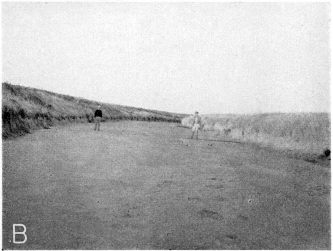
Perhaps the most unusual topographic feature in Scott County is the large depressional area southeast of Scott City at the terminus of Whitewoman Creek, known as the Scott Basin. Whitewoman Creek rises in Colorado about 20 miles west of the state line and flows eastward to a point about 4 miles south of Scott City, where it disappears entirely on the western side of Scott Basin. Throughout its course in Greeley County and the western part of Wichita County, Whitewoman Creek has a prominent channel, often with bluffs from 40 to 75 feet high, and a valley ranging in width from one quarter of a mile to nearly 1 mile. In the western part of Scott County the general inclination of the plains surface to the southeast is approximately 25 feet to the mile, but as the Scott Basin is approached the inclination of the surface declines until at the basin proper it is almost entirely flat. Throughout part of its course in western Scott County, Whitewoman Creek retains definite bluffs and banks (Pl. 3B), but these features gradually disappear as the Scott Basin is approached. A similar change takes place in the valley of Rocky Draw, which is tributary to Whitewoman Creek. The Scott Basin is dry during most of the year, but occasionally it becomes flooded after receiving the floodwaters of Whitewoman Creek as a result of heavy precipitation in the western part of its drainage basin. During periods of flood flow considerable water stands in the basin, forming a lake that sometimes covers several square miles. Most of this water sinks rapidly into the ground, disappearing completely in a relatively short time.
Plate 3B—View of dry floor of Whitewoman Creek at site of well 212 located on left bank just outside photo.
The northwestern quarter of the county is drained by Beaver Creek or Ladder Creek which heads in Colorado just west of the state line, flows eastward, and enters Scott County at a point about 812 miles south of the northwest corner. From this point it continues eastward for approximately 9 miles, then turns rather abruptly to the north, continues in this direction until it leaves the county about midway along the northern boundary, and eventually joins Smoky Hill River in Logan County.
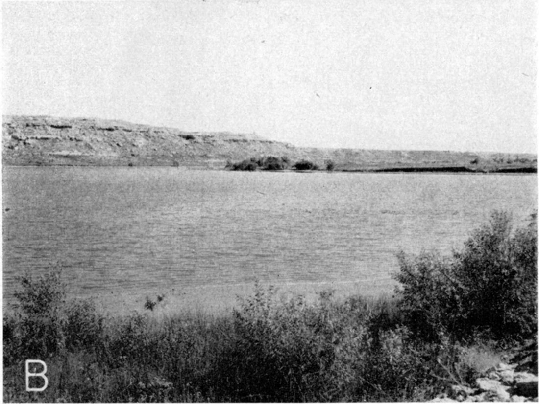
Along the northern border of the county there are a number of short canyons which are tributary to Smoky Hill River to the north. In the northeastern quarter of the county most of the short northeastward-trending canyons are tributary to Rattlesnake Creek which flows in an easterly direction in Logan County and practically parallels the county line for a distance of several miles before it turns northward to join Smoky Hill River. Most of these tributaries have deep, rugged canyons and where dissecting streams have cut through the Ogallala formation into the underlying Smoky Hill chalk, the valleys are deep and have strong bluff lines (Pl. 4B). In northern Scott County the State of Kansas has purchased an area of decidedly picturesque appearance and by means of a dam across Beaver Creek has impounded a lake, known as Lake McBride, with a shoreline several miles long (Pl. 1). In the vicinity of the park the bluffs bordering Beaver Creek are lined with nearly horizontal beds of resistant sandstone and grit of the Ogallala formation (Pl. 5B).
Plate 4B—Typical view of a tributary stream in the NE SW sec. 1, T. 16 S., R. 32 W. Ogalla formation caps bluff in background; Smoky Hill chalk member of the Niobrara in lower slope. Looking east.
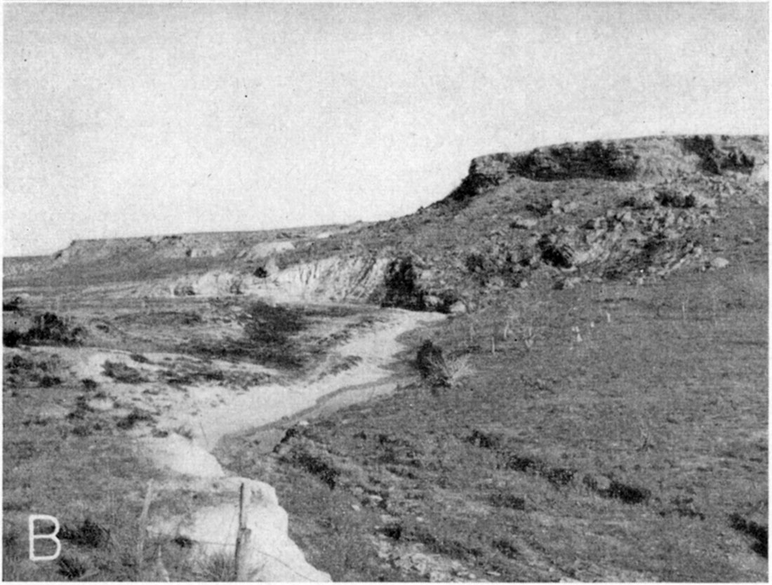
Plate 5B—View looking southeast across Lake McBride in Scott County State Park. Ledges of Ogallala formation are prominent in bluffs in background.
Population
According to the census of 1945, Scott County had a population of 3,769 and an average density of population of 5.2 inhabitants to the square mile, as compared with 21.9 for the entire state. The population in 1930 was 3,976, indicating a reduction of 199 during the decade. Scott City, the county seat, had a population of 2,022 in 1945, having increased from a population of 1,544 in 1930. Population figures are not available for Modoc, Manning, Grigston, or Shallow Water.
Transportation
Scott County is served by the main line of the Missouri Pacific Railway as well as by a branch line of the Atchison, Topeka, and Santa Fe Railway. The main line of the Missouri Pacific Railway enters the county about 2 miles northeast of Manning, continuing diagonally southwest to Scott City, then due west to the county line. The Great Bend and Garden City branch of the Atchison, Topeka, and Santa Fe Railway enters the county about 2 miles east of Grigston, continuing due west to Scott City where it turns due south and joins the main line at Garden City.
U.S. Highway 83 (oil-surfaced) extends across the county in a north-south direction, entering the county about midway along the northern border, continuing south through Scott City to Garden City. State Highway 96 (oil-surfaced) extends across the county in an east-west direction and passes through Scott City. State Highway 4 (gravel-surfaced) enters the county 7 miles south of the northeast corner and continues due west for 12 miles where it terminates at its junction with U.S. Highway 83. Many of the farm-to-market roads have been improved but most of them have not been surfaced. Many of the county roads are graveled and are kept in good condition throughout the year, and many of the section roads have been graded.
Agriculture
Agriculture is the dominant economic activity in Scott County, the principal types of agriculture being wheat farming, some cattle raising, and general farming. Wheat is the most important crop grown in the county but other principal crops are barley, corn, the grain sorghums, alfalfa, oats, potatoes, and melons. Scott City serves as a distributing center and trading point for much of the county. The presence of a shallow water basin in Scott County has made possible irrigation by pumping from wells. In 1943 approximately 21,320 acres were irrigated from wells in the county and there were 118 pumping plants in operation. By June 1945 the number of operating pumping plants had increased to 129.
Scott County has a total area of approximately 462,720 acres. According to the census of 1940, about 38 percent of the land in use in 1939 was devoted to crops and about 62 percent to grazing. In 1940, 6 percent of the farms were less than 100 acres in size, 14 percent of the farms ranged in size from 100 to 259 acres, 25 percent ranged from 260 to 499 acres, 29 percent ranged from 500 to 999 acres, and 26 percent were 1,000 acres or larger. On April 1, 1940, Scott County had 528 farms with an average area of 822.8 acres.
Natural Resources and Industries
The chief industry in Scott County is an oil refinery, known as the Shallow Water Refining Company, situated 4 miles south of Shallow Water. Crude oil obtained from the adjoining Shallow Water oil pool is processed at this refinery, which has a capacity of 1,500 barrels daily. The Shallow Water oil pool, in secs. 11, 14, and 15, T. 20 S., R. 33 W., was discovered by the Atlantic Oil Producing Company when the first well on the Vaniman farm was completed in December 1934. Oil with an unusually heavy gravity of 26 degrees Baume was found 5 feet below the top of the "Mississippi lime" which was encountered at a depth of 4,665 feet. At the end of 1942 there were nine wells in the Shallow Water poo1. According to Ver Wiebe (1943, p. 72), the Shallow Water pool produced 112,948 barrels of oil in 1942. The cumulative total production to the end of 1942 was 1,152,560 barrels.
The other principal mineral resources in Scott County are the deposits of sand and gravel found along the sides of Beaver Creek and in the Scott Basin and the deposits of caliche near the top of the Ogallala formation. The sand and gravel are quarried extensively for local use. The locations of the more important pits are shown in Plate 1. All of the gravel pits are worked by open-pit methods and are excavated by shovels. The locations of the two most important caliche quarries are also shown in Plate 1. One is located 2 miles south and 2 miles east of Scott City and is used extensively for road-surfacing material for county roads (Pl. 6B), and the other is located near the SE cor. sec. 2, T. 17 S., R. 33 W. The latter quarry was the principal source of crushed caliche that was used in 1940 and 1941 for surfacing U.S. Highway 83 north from Scott City to the county line.
In 1937 samples of rock were collected from exposures of the Ogallala formation at two localities in Scott County, and tests were made to determine their suitability for making rock wool (Plummer, 1937, pp. 25-27). Samples were collected from an escarpment of the Ogallala formation on the east edge of Scott County State Park in a road cut on the highway which extends east from the park to U.S. Highway 83. Of a vertical distance of 53 feet which was sampled at this locality, only the upper 20 feet contained sufficient calcium carbonate to be classed as wool rock. Samples were collected also from an outcrop of the Ogallala on the John Kittle farm about 300 yards east of the Wichita-Scott County line in sec. 6, T. 19 S., R. 34 W., about 3 1/2 miles south of State Highway 96. One of the samples collected at this locality produced an excellent quality of white wool at a pouring temperature of 1525° C with the steam pressure varying from 50 to 55 pounds. Plummer (1937) reports that an outcrop of the "mortar beds" (Ogallala formation) similar to the exposure near the Wichita-Scott County line was observed about 8 miles west of Scott City, a short distance south of State Highway 96 on the banks of Lion Creek.
Climate
In general the climate of Scott County is typical of semiarid regions and is characterized by abundant sunshine, moderate precipitation, relatively good wind movement, relatively low humidity, and a high rate of evaporation. Occasionally during the summer months hot winds which blow during a dry heated period are the cause of great crop damage and much discomfort.
Winter months generally are slightly colder and windier than in eastern Kansas and somewhat drier. Snowfall is normally light and is often accompanied by high winds with a resultant uneven distribution.
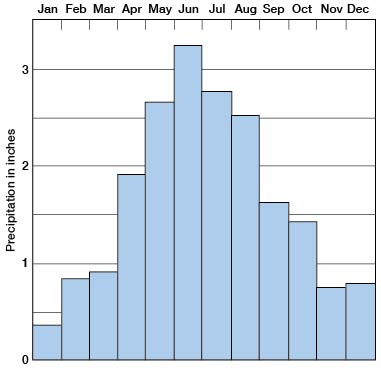
The amount of precipitation and its seasonal distribution are the chief limiting factors of crop growth. During the years for which records have been kept approximately 75 percent of the annual precipitation falls in the six months from April to September inclusive, when the growing season is at its height and moisture is needed. The normal monthly precipitation during the period of record at Scott City is shown in Figure 3.
Figure 3—Normal monthly precipitation during the 35-year period of record at Scott City, Kansas.
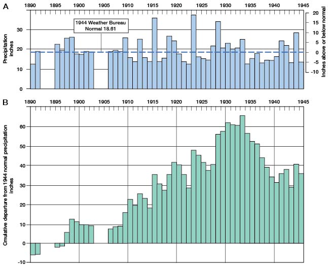
According to the U.S. Weather Bureau the normal annual precipitation at Scott City is 18.61 inches. The annual precipitation and the cumulative departure from normal precipitation at Scott City are shown in Figure 4. During the period from 1930 to 1940, the precipitation was below normal in 1931 and from 1934 through 1940. The cumulative deficiency during the 7-year period from 1934 through 1940 amounted to 26.41 inches, or 1.4 year's normal annual precipitation. The precipitation was above normal in 1941 and 1942, but fell below normal again in 1943. In 1943 the precipitation was below normal for each of the 12 months during the year, a total departure of -8.23 inches being recorded, or almost one-half of the total normal annual supply. In 1944, the precipitation was 11.31 inches above normal and in 1945 it was 4.39 inches below normal.
Figure 4—Annual precipitation and cumulative departure from normal precipitation at Scott City.
The average annual mean temperature as recorded at Scott City is 53.5° F. The average length of the growing season is about 168 days, and it has ranged from 132 to 199 days. Killing frosts have occurred as late as May 27 and as early as September 25.
Prev Page—Introduction || Next Page—Geology
Kansas Geological Survey, Geology
Comments to webadmin@kgs.ku.edu
Web version March 2003. Original publication date July 1947.
URL=http://www.kgs.ku.edu/General/Geology/Scott/03_geog.html