![]()
Prev Page—Contents || Next Page—Geography
Introduction
Purpose and Scope of the Investigation
The investigation upon which this report is based is part of an extended program of ground-water investigations in Kansas begun in July 1937 by the United States Geological Survey and the State Geological Survey of Kansas in cooperation with the Division of Sanitation of the Kansas State Board of Health and the Division of Water Resources of the Kansas State Board of Agriculture. The investigation in Scott County is similar to studies that have been completed or are being conducted in other counties in southwestern Kansas. Studies of this type are important because of the progressive increase in the use of ground water for irrigation in this part of the state as a result of a prolonged period of subnormal precipitation from 1932 to 1939. Pumping from wells for irrigation has been practiced for many years in favorable areas in western Kansas. These new ground-water developments cannot be expanded indefinitely without causing overdevelopment. Investigations of the geology and ground-water resources of such areas should show to what extent the ground-water supplies will be perennial. In this connection systematic observations of water levels in carefully selected wells have been and are being made in order to determine the changes in ground-water storage and to check preliminary conclusions as to the safe yield of the water-bearing formations. This report gives the results of a study of the geology and ground-water resources of Scott County that was begun in September 1939.
The shallow-water basin in central-southern Scott County and the adjacent part of northern Finney County is quite well known because ground water is obtainable from irrigation wells at reasonably shallow depths. The development and use of ground water for irrigation in that part of the basin lying in Scott County began about 1910 and reached its peak during the last decade as a result of a prolonged period of subnormal precipitation. According to records of the Division of Water Resources of the State Board of Agriculture, the irrigated acreage in the Scott shallow-water basin has increased from 1,021 acres in 1932 to 21,320 acres in 1943. At the end of 1936 there were approximately 30 operating irrigation wells in the area, whereas in 1945 there were 129.
Location and Extent of the Area
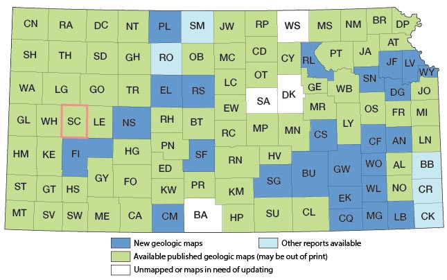
Scott County lies in the third tier of counties east of the western border of the state and about midway between the north and south borders; it embraces a total of 723 square miles. Its location with respect to adjoining counties is shown by Figure 1.
Figure 1—Index map of Kansas showing area described in this report and areas covered by other geologic maps, as of March 2003. For additional information, please visit the KGS Geologic Maps of Kansas Page.
Previous Investigations
The more important studies dealing with the geology and groundwater resources of southwestern Kansas that have a bearing on Scott County are cited below. Specific references are cited at appropriate places in the text by author and date of issue and are listed in the bibliography at the end of the report.
In 1892, Colonel Nettleton (1892, pp. 26-27, appendix No. 10) reported on the results of some underflow surveys along the Arkansas River valley including a discussion and plat of a north-south profile of the water table extending from Beaver or Ladder Creek near Scott City south through Garden City to an abandoned post office called Loco. In 1897, Haworth (1897, p. 94 and pp. 110-112; 1897a) made reference to geologic and hydrologic conditions in parts of Scott County. Two other papers were contributed by Haworth in 1897, one (1897b) on the physiography of western Kansas and the other (1897c) on the physical properties of the Tertiary rocks in Kansas. Johnson's report on the utilization of the High Plains (1901) dealt with the physiography, underground waters, and the land economy of the High Plains. A second report (Johnson, 1902) contained conclusions and a summary of the first paper. In 1905, Darton (1905, p. 316) published a preliminary report on the geology and ground-water resources of the central Great Plains, in which he made brief reference to Scott County. In 1911 a report which contained a brief reference to the chemical quality of several waters collected in Scott County was published by Parker (1911, pp. 179-180). A report that contained the results of a reconnaissance soil survey of the western half of Kansas, including Scott County, was published by Coffey and Rice in 1912. Haworth (1913, pp. 61, 66-68) contributed a report on well waters in southwestern Kansas in which specific reference was made to Scott County. In 1931 the Division of Water Resources of the Kansas State Board of Agriculture published a report (Anon., 1931) that contained a description of some of the most common types of pumping plants in Kansas with approximate costs of construction. In 1933, Moss described briefly the ground-water resources of the shallow-water basin in Scott and Finney counties. In 1935, Theis, Burleigh, and Waite (1935) described briefly the water-bearing formations and the availability of ground water in the southern High Plains. In the same year a popular bulletin (Landes, 1935) containing a brief description of Scott County State Park was published. In 1936 a report on irrigation with ground water in the Scott County, Kansas, area by Burleigh (1936) was released confidentially. A report by Throckmorton and others (1937, pp. 69-71) on the agricultural resources of Kansas including important statistical data for Scott County was published in 1937.
In 1938, the Division of Water Resources of the Kansas State Board of Agriculture published a report (Anon., 1938) containing the results of tests of deep-well pumping plants with special attention to fuel consumption. Several of the plants tested are located in Scott County. In 1939, Davison (1939) contributed a report on the construction and costs of irrigation pumping plants in Kansas. Also in 1939, McCall and Davison (1939) contributed a report on the costs of pumping for irrigation that includes data on several tests of irrigation pumping plants in Scott County. A report (Meinzer and Wenzel, 1940, pp. 184-198) on water levels and artesian pressures in the United States in 1939, which contains a chapter on the observation well program in Scott County, was published in 1940. Similar reports have been published for the years 1940, 1941, and 1942 (Meinzer and Wenzel, 1942, pp. 152-163; 1943, pp. 132-139; and 1944, pp. 153-158), and additional reports of this series will be published annually. In 1940, Moore prepared a generalized report on the ground-water resources of Kansas, which includes a section on Scott County. A report by Smith (1940) includes several references to the geology of Scott County. In 1939 and 1940 McLaughlin (1943) made a study of the geology and ground-water resources of Hamilton and Kearny counties adjoining the southwest corner of Scott County. In 1939 and 1940 Latta (1944) made a study of the geology and ground-water resources of Finney and Gray counties which border Scott County on the south. Other county reports describing the geology and ground-water resources of southwestern counties include Stanton County (Latta, 1941), Morton County (McLaughlin, 1942), Ford County (Waite, 1942), and Meade County (Frye, 1942). In 1942 Bird made reference to ground-water conditions in the Scott County shallow-water basin in a report on the western ground waters and food production. A geologic map of Kansas, which includes Scott County, was prepared under the supervision of Moore and Landes in 1937. In 1941, I (Waite, 1941) contributed a paper on the cause of the decline in ground-water levels in Scott County. A report on the availability of ground-water supplies in Kansas for national defense industries (Lohman and others, 1942, pp. 37-39) that includes a discussion of a part of Scott County was published in 1942. A report (McCall, 1944) on the growth of irrigation in Scott County was prepared by the Kansas State Board of Agriculture in 1944. Moore, Frye, and Jewett prepared a tabular description of all rocks that crop out in the state in 1944. In 1945 (Edson) the State Geological Survey of Kansas published a subsurface geologic cross section that extends through Scott County.
Methods of Investigation
Most of the field work upon which this report is based occupied about 1 month in the fall of 1939 and about 3 1/2 months in the summer and fall of 1940. Approximately 282 wells in the county were visited and the total depth and depth to water level below land surface in most of them were measured with a steel tape. Well owners and drillers were interviewed regarding the nature and thickness of the water-bearing formations penetrated by the wells, and all available logs were collected. Records of wells that furnish public, domestic, and irrigation supplies were collected. Information regarding the yield, drawdown, temperature, chemical character, and use of ground water was obtained. Since 1931 an annual survey of the acreage irrigated has been made by Kenneth McCall, Melvin Scanlan, or Howard Palmer of the Division of Water Resources, State Board of Agriculture.
Samples of water were collected from 29 representative wells and 1 spring and were analyzed by Elza H. Holmes, chemist, in the Water and Sewage Laboratory of the Kansas State Board of Health at Lawrence. In addition an analysis of water from the public supply at Scott City (well 112) was furnished by the Kansas State Board of Health, making a total of 30 analyses for Scott County.
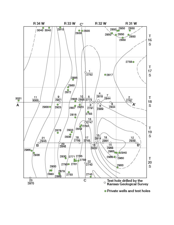
During the investigation 23 test holes (Fig. 2) were put down at strategic points in Scott County by Ellis Gordon, Perry McNally, and Laurence Buck with a portable hydraulic-rotary rig owned by the State Geological Survey. Samples of drill cuttings were collected and studied in the field by Perry McNally and were examined later in the office under binocular microscope.
Figure 2—Configuration of the pre-Tertiary surface of Scott County by means of contours, location of test holes, and locations of cross sections shown in Figure 5.
Altitudes of the measuring points at 207 wells and at each of the test holes put down by the drilling rig were established with a Dumpy level. The levels were run from elevations established in 1938 and 1939 by the Topographic Branch of the U.S. Geological Survey and in part from benchmarks of the United States Coast and Geodetic Survey by me assisted by J. Milton Sears and Richard B. Christy. The water-table contour map (Pl. 1) is based upon these altitudes together with the measured depths to water level in wells.
Field data were compiled on preliminary topographic sheets of the U.S. Geological Survey and on an ownership map of Scott County. The base maps for Plates 1 and 2 were prepared from a county map compiled by the State Highway Department. The locations of the roads were corrected from observations in the field and the drainage was corrected from aerial photographs obtained from the United States Department of Agriculture, Agricultural Adjustment Administration.
The areal geology shown in Plate 1 was compiled from field studies supplemented by use of the aerial photographs and by available geologic reports. The boundaries of the areas of dune sand were taken from aerial photographs supplemented by observations in the field.
The locations of all wells for which descriptions are given in the tables of well records are shown in Plate 2. Two numbers are shown opposite each well symbol, the upper one corresponding with that used in the well tables in the text, and the lower one corresponding with the depth to water level below the land surface.
The wells are numbered consecutively by townships from north to south and by ranges from east to west. Within each township the wells are numbered in the same order as the sections. Within each section the wells are numbered in the sequence of the sixteen 40-acre tracts into which sections are divided by the General Land Office, as shown in the explanation of Plate 2.
At the beginning of the field investigation 29 observation wells were selected at strategic points throughout the county and monthly measurements of the water levels in them were begun in order to obtain essential information concerning the effects of recharge and depletion of the ground-water reservoir. Two wells of this group were equipped with automatic water-stage recorders during the period from September 1939 to July 1941 for the purpose of obtaining continuous records of water-level fluctuation. The Division of Water Resources of the State Board of Agriculture has maintained similar records on two other wells in the same area for several years. The water levels have been observed continuously in one of the wells since October 23, 1931, and in the other since April 18, 1934. A third well was constructed and equipped with a continuous recorder in August 1940 by the Division of Water Resources after the water level in the well with the oldest record was lowered as a result of pumping from a new irrigation well that was drilled nearby. These water-level records have proven invaluable in interpreting the trends in movement of water levels in the Scott Basin and in determining the effects of pumpage and of subnormal precipitation during the last several years.
Acknowledgments
The writer is indebted to the many residents of the county who readily gave permission to measure their wells and who supplied helpful information regarding them. Special acknowledgment should be given to the fine cooperation of all the well drillers in the county for making available to the writer well logs and in some cases samples of water-bearing materials. George S. Knapp, Chief Engineer of the Division of Water Resources, Kansas State Board of Agriculture, made available unpublished data relating to wells and assigned members of his staff to make an irrigated acreage survey in collaboration with me and to conduct pumping tests on several irrigation wells. He has made many helpful suggestions regarding the preparation of this report and has assisted in its preparation in many ways. Harold T. U. Smith, of the Department of Geology, University of Kansas, made many helpful suggestions both in the field and in the office. Claude W. Hibbard, formerly curator of vertebrate paleontology of the Dyche Museum of Natural History, University of Kansas, identified vertebrate and invertebrate material collected in Scott County. Identifications of Pleistocene freshwater mollusks collected in Scott County were made by A. Byron Leonard, associate professor, Department of Zoology, University of Kansas. The writer is indebted to Mr. Knapp and to members of the Geological Survey office in Lawrence for assistance during the completion of this report.
Acknowledgment for helpful information is given to the following persons: Myron F. Robbins, John Boyer, Howard A. Geer, W. A. Laughlin, Thomas L. Sherry, and Claude Beckley, all of Scott City.
The manuscript for this report has been reviewed critically by several members of the Federal Geological Survey; Raymond C. Moore, State Geologist and Director of Research, and John C. Frye, Executive Director, State Geological Survey of Kansas; George S. Knapp, Chief Engineer, and Robert Smrha, Assistant Chief Engineer, Division of Water Resources of the Kansas State Board of Agriculture; and Paul D. Haney, Director, and Ogden S. Jones, Geologist, Division of Sanitation of the Kansas State Board of Health. The illustrations were drafted by Robyn Ashby Addis of the Kansas Geological Survey and W. W. Wilson and Murl H. Rush, Jr., of the Federal Geological Survey. The manuscript was edited by Betty J. Hagerman of the Kansas Geological Survey.
Prev Page—Contents || Next Page—Geography
Kansas Geological Survey, Geology
Comments to webadmin@kgs.ku.edu
Web version March 2003. Original publication date July 1947.
URL=http://www.kgs.ku.edu/General/Geology/Scott/02_intro.html