![]()
Prev Page--Council Grove Group || Next Page--Leonardian Series
Stratigraphy, continued--Permian System, continued
Wolfcampian Series, continued
Chase Group
The Chase Group was named from Chase county, Kansas by Prosser (1902, pp. 713-714). He included beds from the base of the Wreford formation to the top of the Winfield formation (not including Luta limestone,). The upper boundary of the group is now placed higher, at the top of the Herington limestone, the upper member of the Nolans formation. As originally defined the Chase Group was said to be a well-defined lithologic and faunal unit, but there seems to be no good reason for excluding strata between the top of the Winfield and Nolans formations. Flint-bearing limestones are characteristic of the group, but it includes limestones that are not flinty and shales of various colors. Flint is abundant in the Florence limestone in the Barneston formation, in the Wreford limestone, and locally in the Winfield and Nolans limestones. Flint in the Kansas Permian rocks, however, is not confined to the Chase Group. In southern Kansas various limestones in the Council Grove group are locally flinty.
Wreford limestone
Hay has been given credit for naming the Wreford limestone formations but he merely suggested the name with reservations. In 1891 he (Hay, 1891) suggested Wreford or Ogden as suitable names for these strata and again in his posthumous paper (Hay, 1896) he says:
"If another name were required for these strata we might still call the lower flint the Wreford formation; however ... some other geographic term would perhaps be more appropriate."
In spite of his statement the name has become firmly established. The name is unfortunately chosen, as the type exposure in the old quarries at Wreford, a village in Geary County 5 miles south of Junction City, is very poor.
The Wreford limestone formation is composed of three members, which Condra and Upp (1931, p. 31) have named, in ascending order: (1) Fourmile limestone, (2) Havensville shale, and (3) Schroyer limestone. Because the term Fourmile has previously been applied to a Pennsylvanian sandstone in the Osage Reservation, Oklahoma (Bowen, 1922, p. 19), the Kansas Geological Survey has substituted the term Three mile, the name of a creek that crosses Fort Riley Military Reservation and is tributary to Kansas River a few miles southwest of Odgen.
Threemile limestone member
The term Fourmile limestone was applied to the lower member of the Wreford formation by Condra and Upp in 1931, from Fourmile creek near the Kansas-Nebraska boundary, south of Humboldt, Neb. As stated, the name Fourmile was used by Bowen to designate a sandstone formation of Pennsylvanian age in Oklahoma. The name, Threemile is taken from a creek that crosses Fort Riley Military Reservation and empties into Kansas River a few miles southwest of Ogden.
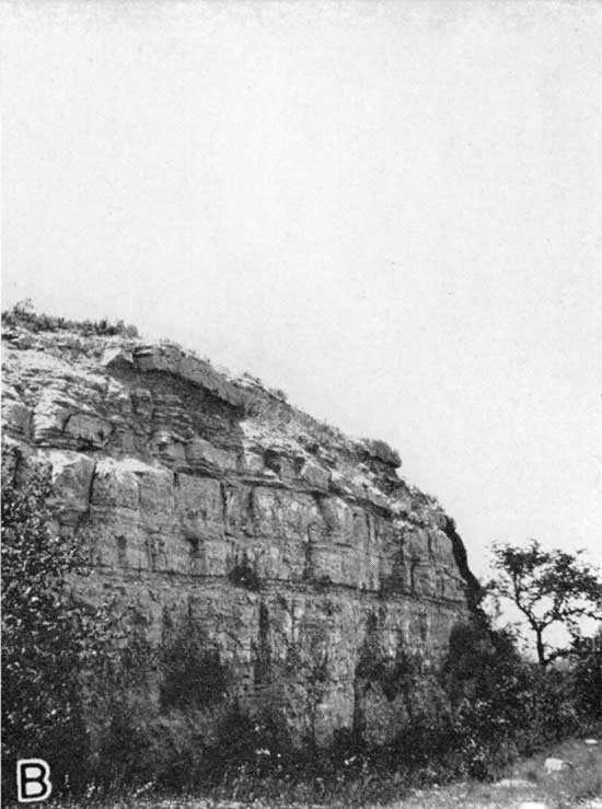
Plate 2B--Characteristic exposure of Threemile limestone, Wreford formation, eastern Riley County.
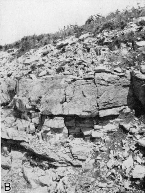
Lithologic Character and Thickness--The lowest, 2 or 3 feet of the lower member of the Wreford formation consists of thin beds of limestone containing abundant nodules of flint. The overlying bed is lighter in color and contains little or no flint. In most places where the bed can be seen there is no flint; the limestone is massive everywhere makes a bold outcrop. The thickness is almost uniform, and is approximately 7 feet. Because of the lack of flint, this bed is resistant to weathering and forms a dip slope over a wide area in the Flint Hills. As already explained under the heading "the Flint Hills report", it is not the flint-bearing limestones that are most resistant to weathering in this part of Kansas. This non-flinty limestone bed is conspicuous whether high or low topographically and is by far the most noticeable part of the Wreford formation. The overlying part of the Threemile limestone in the two counties, is flinty and thin-bedded. The thickness of the entire member is approximately 9 feet. Plates 2B, 13, and 14A show various parts of the Wreford limestone.
Distribution--A line marking the base of the Threemile limestone appears on the geologic map (pl. 1) as the base of the Wreford formation. The distribution of the three members is nearly the same and is discussed after the description of the upper member.
Detailed sections--for detailed sections of the threemile limestone see see sections 2, 10, 11, 32, 42, 49, 57, 59, 66, 68, 69, and 70 at the end of this report.
Havensville shale member
Condra and Upp (1931, p. 32) chose exposures near Havensville in Pottawatomie county, Kansas, as typical for the middle member of the Wreford formation. It is described as olive-colored argillaceous shale containing fossiliferous transitional zones at top and bottom, 18 or more feet thick at the type locality.
Lithologic Character and Thickness--In Riley and Geary counties the, Havensville shale is approximately 10 feet thick or locally slightly thicker. It is gray, argillaceous, and fossiliferous. Brachiopods, pelecypods, and a few bryozoa are characteristic. The fossils are almost confined to the upper and lower parts.
Distribution--The Havensville shale is almost coexistent with the upper member of the Wreford formation.
Detailed sections--for sections including the Havensville shale see numbers 11, 32, 42, 66, 67, and 68 at the end of this report.
Schroyer limestone member
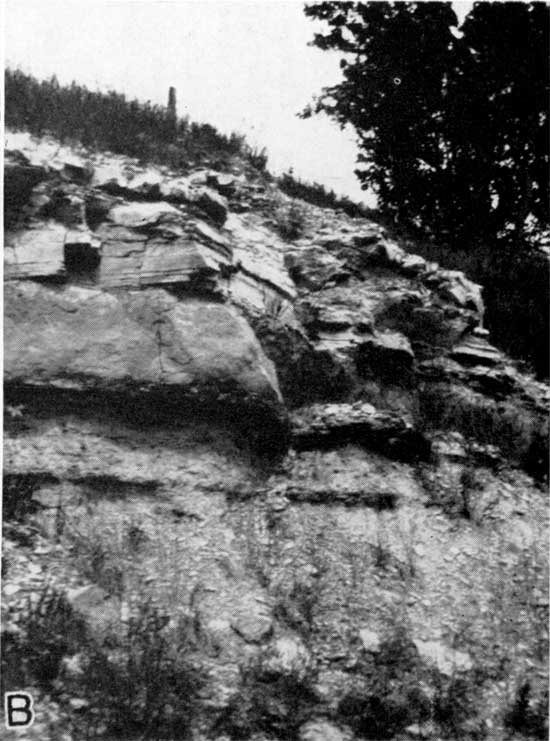
The type exposure of the upper member of the Wreford formation is about one and one fourth miles below Schroyer a town in Marshall county, Kansas, about 8 miles north of Riley County (Condra and Upp, 1931, p. 32).
Plate 13--Characteristic exposure of the Schroyer limestone, Wreford formation, eastern Riley County.
Lithologic Character and Thickness--The Schroyer limestone is mostly flinty, but contains generally a bed of non-flinty limestone, which crops out more prominently than the rest of the member. The bed contains no flint lies at or near the top and is commonly about 3 feet thick. The thickness of the member is about 18 feet.
Distribution--The various members of the Wreford limestone formation are exposed near the tops of the hills a few miles east, and a few miles north of Manhattan. The formation is easily traced up the tributary to Kansas River. It is partly exposed at Ogden an north of U.S. Highway 40 north of Camp Funston. Back the remount station near the west gate Camp Funston it is partly exposed in a quarry. At the bridgehead on the east, bank of Smoky Hill river east of Junction City the base of the Threemile limestone is slightly higher than the level of the bridge and most of the formation is concealed. The formation extends northward up Big Blue river beyond the north boundary of Riley County. The Wreford limestone is easily traced because of the resistant non-flinty bed in the Threemile member and the similar one in the Schroyer member. The line of outcrop follows Big Blue river for most of the distance along the eastern edge of Riley County except in those places where it extends westward up eastward-flowing streams tributary to Big Blue river, such as Baldwin creek, Fancy creek, and Sweed creek. Near Winkler on Fancy creek, exposures near the water level show that the Wreford formation is well below the valley fill. Westward a few miles upstream and in the direction of the regional dip the formation appears well above water-level again, indicating the presence of an anticlinal structure.
Detailed sections--Sections 10, 12, 32, 42, 57, 58, 66, 67, and 68 at the end of this report include the Schroyer limestone.
Matfield Shale
Prosser (1902, p,. 714) applied to the strata between the underlying Schroyer limestone and the overlying Florence limestone the name of Matfield, from Matfield township Chase county, Kansas. Condra and Upp (1931, pp. 38-40) divided the formation into three parts, named in upward order: (1) Wymore shale, (2) Kinney limestone, and (3) Blue Springs shale. Later the Kansas Geological Survey recognized these three Units as formations and dropped the term Matfield from stratigraphic nomenclature. Because both on the surface and in the subsurface the Kinney limestone is difficult to, define, retention of the name Matfield as a formation name seems advisable, the smaller units being regarded as members of the formation. The flinty limestones next below and above the Matfield shale are easily recognized and Matfield is a useful name.
Wymore shale member
The type exposure of the Wymore shale is near Wymore Neb. (Condra and Upp, p. 37). The Wymore shale is defined as the shale lying between the Wreford and Kinney limestones, and as the basal member of the Matfield formation.
Lithologic Character and Thickness--The Wymore shale consists of varicolored shales. Shades of red are perhaps the most common colors other than gray, but purple, green, and chocolate-color are common. The approximate average thickness of the member is 20 feet.
Distribution--The members of the Matfield formation lie between two very resistant series of strata and are generally concealed under grassy slopes between the more bold limestone outcrops, but there are some good exposures, such as those in sec. 32, T. 6 S., R. 7 E., along the bluff of Big Blue river between Randolph and Cleburne and in sec. 29, T. 8 S., R. 7 E., about 2 miles northwest of Stockdale.
Detailed sections--for sections of the Wymore shales see numbers 6, 10, 12, 32, 56, 58, 66, 67, and 68 at the end of this report.
Kinney limestone member
The type exposure chosen by Condra and Upp (1931, p. 37) for the Kinney limestone of the Matfield shale is near Kinney, Gage County Nebraska. The Kinney limestone defined as the middle member of the Matfield shale and as lying between the Wymore and Blue Springs shales.
Lithologic Character and Thickness--After studying all available exposures in Riley and Geary counties, I conclude that in that part of Kansas the Kinney limestone formation is best described as a calcareous fossiliferous zone containing limestone lenses. Farther south in Kansas the member more persistently maintains its massive character. Sections at the end of this report giving detailed descriptions of exposure shows the variable character of the member. Along U.S. Highway 40 in Fort Riley, a short distance west of the Ogden monument, is an exposure of a part of the Wymore shale and of the Kinney limestone. There is exposed a bed of limestone 4 feet 4 inches thick, which lies approximately 83 feet below the base of the Fort Riley limestone and probably about 50 feet below the base of the Florence limestone. From sections it can be seen that the thickness of the member ranges from a few feet to perhaps as much as 22 feet.
Distribution--The Kinney limestone member is well exposed in the places mentioned under the discussion of the Wymore shale member. Its distribution in the two counties is nearly the same as that of the base of the Florence limestone of the Barneston formation.
Detailed sections--For sections including the Kinney limestone see numbers 5, 6, 10, 12, 32, 56, 58, 66, 67, and 68 at the end of this report.
Blue Springs shale member
The type exposure of this member is southwest of Blue Springs, Neb. (Condra and Upp, 1931, p. 38). It is the top member of the Matfield shale.
Lithologic Character and Thickness--Blue Springs shale is persistently varicolored below and yellow and gray above. The upper part is more calcareous than the lower. The thickness is variable ranging from approximately 25 feet to 45 feet. The brilliantly colored material in this formation and in the underlying Wymore shale exhibit the brightest colors found in rocks in this part of Kansas and the brightest in the state in any rocks other than the "redbeds" higher in the Permian system. Red, purple, chocolate color, and shades of green are very noticeable in the lower part of the Blue Springs shale.
Distribution--The Blue Springs shale is exposed in many road cuts and elsewhere along the Flint Hills where the Fort Riley and Florence limestones cap the hills. It is present over a wide area below the more resistant limestones.
Detailed sections--For sections of the Blue Springs shale member see numbers 5, 6, 10, 12, 15, 32, 56, 58, 66, 67, and 68 at the end of this report.
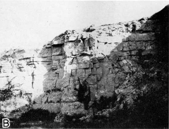
Barneston Limestone
Condra and Upp (1931, p. 41) erected a formation to include two well-known Kansas stratigraphic units, the Florence and Fort Riley limestones. The formation was named Barneston from the town in Gage County, Nebraska. Later the Kansas Geological Survey recognized a shale member between the limestones. Hence the Barneston formation is now, divided, in ascending order, into: (1) Florence limestone, (2) Oketo shale, and (3) Fort Riley limestone.
Plate 2A--A streamcut cliff in Barneston limestone, sec. 1, T. 7 S., R. 5 E., Riley County.
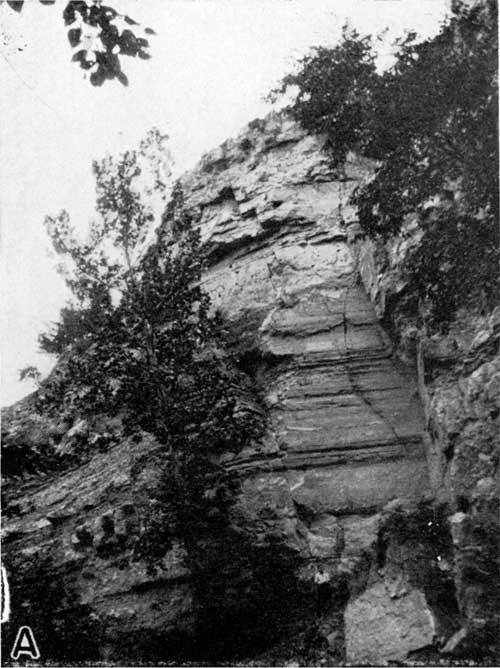
Plate 15B--An exposure of Barneston limestone in an old quarry, sec. 20, T. 11 S., R. 5 E., Riley County.
Florence limestone member
The Florence limestone was named by Prosser (1895, p. 773) from exposures near Florence in Marion County, Kansas. Because of the large amount of flint or chert it contains, the limestone has been generally known as the Florence flint.
Lithologic Character and Thickness--The Florence limestone is very noticeable because of the large amount of steel-gray flint imbedded within the limestone. The thickness ranges from 33 feet to 45 feet. This flint consists of very irregular nodules, which are arranged in layers 1 to 6 inches thick. The non-flinty limestone layers are characteristically 9 inches thick. The member is in reality a series of beds of limestone and beds of lint, but shale breaks are common near the top, if the uppermost flint-bearing limestone bed is regarded as the top of the member, there are commonly two shale breaks within the uppermost 10 feet. A characteristic exposure shows a shale bed 18 inches thick about 2 feet below the top and another, 3 feet thick, about 10 feet below the top. Commonly the limestone is somewhat powdery and weathers easily. The Florence member is somewhat fossiliferous. An exposure south east of Winkler in sec. 1, T. 7 S., R. 5 E., along Fancy Creek, is perhaps the best place within the two counties at which to collect fossils from the Florence member. The common lower Permian brachiopod, pelecypods, and bryozoa are plentiful there. Fusulinids are present in the member but are scarce.
Distribution--The resistant Fort Riley limestone, which lies a few feet above the Florence limestone, is the bold outcrop-maker and forms the floor of extensive dip slopes, where as the Florence limestone itself is more commonly concealed under steep slopes. That the flinty limestone although 40 feet thick is unable to form dip slopes is demonstrated in the hundreds of rounded buttes that fringe the Fort Riley limestone outcrop. From the top of all these buttes the Fort Riley member is absent, and as soon as the Fort Riley stratum weathers away the Florence limestone is rapidly dissected, and topography is developed, that is very different from that in the extensive areas underlain by the Fort Riley. The height of the buttes capped by the flinty Florence limestone is generally slightly less than the thickness of the interval between the Schroyer limestone and the Florence. The Kinney limestone does not protect dip slopes.
The Florence limestone is partly exposed in many places below the "rim rock" or main ledge of the Fort Riley limestone. In only a few places is the whole member exposed. Representative exposures are described among the detailed sections that are included at the end of this report. as already explained, the member caps hundreds of rounded buttes east of and below the Fort Riley line of outcrop. These constitute a part of the Flint Hills. Where streams are actively eroding, the Florence stands in sheer cliffs; examples of such topographic expression are to be seen on Fourmile Creek near the northwest edge of the Fort Riley Military Reservation and on Fancy creek near Winkler. Plate 2A shows the exposure near Winkler. In the general Flint Hills type of topography there are few natural exposures of the flint-bearing ledge, so one must rely upon artificial exposures for places in which to study it. The numerous artificial exposures have uncovered many good sections; an old quarry along the right valley wall of Smoky Hill river opposite Junction City is pictured in Plate 14B.
Plate 14B--An exposure of Barneston limestone in an old quarry above the right bank of Smoky Hill river opposite Junction City, Geary County.
Detailed sections--For complete descriptions of exposures of Florence limestone see numbers 5, 6, 9, 10, 12, 15, 32, 39, 56, 58, 66, 67, and 68 along the sections at the end of this report.
Oketo shale member
A definition of the Oketo shale, which is the middle member of the Barneston, has not heretofore appeared in geologic literature. It is well established, however, as a stratigraphic name because of its use on several published graphic sections (Moore, 1936b, figs. 4 and 45 1940, fig. 15) and Moore is the author of the term. The name is derived from the town Oketo, Marshall County, Kansas. It may be defined as the middle member of the Barneston limestone, a bed of shale separating the flinty Florence limestone below from the Fort Riley limestone. Its thickness ranges from a feather edge to several feet. It is calcareous and locally contains one or more beds of limestone. The top of the Florence limestone is placed at the top of the uppermost flint-bearing beds in the Barneston limestone, and the base of the Fort Riley limestone is placed at the base of the lowermost limestone layers directly below the strata to which the name Fort Riley was originally applied. Wherever shale occurs between the Florence and Fort Riley limestones, as their boundaries are thus defined, the shale is properly called Oketo. The Oketo shale is present over a wide area in Kansas but is absent in some exposures of the Barneston limestone, especially in the southern part of the state.
Lithologic Character and Thickness--The thickness of the Oketo shale ranges in Riley and Geary counties form a mere sheet to 17 feet. The shale is bluish-gray and yellow; local limestone beds are light in color and somewhat earthy. the greatest thickness in the area studied was the 17 feet of fossiliferous gray shale containing some dark carbonaceous material in the lower part, which was measured in sec. 6, T. 6 S., R. 7 E. In sec. 13. T. 9 S., R . 6 E., the Fort Riley and Florence limestones seem to be in direct contact. Gray-blue shale 6 or 8 feet thick containing thin limestone beds near the top and calcareous material in the very uppermost part is characteristic of the Oketo shale in the two counties.
Distribution--The Oketo shale has the same distribution in the two counties as has the base of the Fort Riley limestone. The distribution of the Fort Riley member is hereinafter discussed in some detail.
Detailed sections--For sections including the Oketo Shale see numbers 6, 9, 15, 32, 56, 66 and 67 at the end of this report.
Fort Riley limestone member
Much of the beauty of the Flint Hills country near the larger streams is due to the presence of the Fort Riley limestone, a part of which forms hundreds of miles of outcrop line in the form of a natural wall of white limestone.
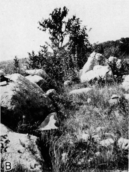
Plate 3B--Residual boulders of Fort Riley limestone near Junction City Country Club, Geary County.
Swallow (1866, p. 141) used the name Fort Riley limestone in 1866, but he applied the name to only the more conspicuous part, which crops out more commonly. Meek and Hayden (1859, p. 79) had used "bed No. 12" to designate the same part. Hay (1896, p. 18) wrote of the "Fort Riley main ledge" in reference to the same part, which is so prominent along the river bluffs on and near Fort Riley Military Reservation. Prosser (1895, p. 773) used the term "Florence limestone" for the main part, but Prosser and Beele (1904, p. 4) extended the name Fort Riley "to include the thinner bedded limestone both above and below the massive Fort Riley main ledge." The type locality is the Fort Riley Military Reservation.
Lithologic Character and Thickness--The lower beds of the Fort Riley limestone are so nearly constant in their wall-like outcrop that travelers are inclined to believe that they are looking at an artificial wall. Plate 4B shows this remarkable feature. This portion of the Fort Riley limestone, which crops out so conspicuously and so constantly, is often termed the "Fort Riley rim rock." It is a massive ledge lying not far above the base of the member. It has been extensively quarried and used in building, particularly in Junction City and Fort Riley, as it is well adapted for cutting into dimension blocks. There are still numerous quarry sites in the two counties. Plate 3B shows an exposure of the "rim rock"" after it has been subjected to prolonged weathering. Blocks of this kind form the natural walls around the hills. Beds below the massive outcrop maker are composed of thinner, argillaceous layers. The thickness differs at different exposures.
Above the massive beds are thinner beds of limestone and shale. Not far from the middle of the Fort Riley limestone is a very persistent zone of extremely platy beds of argillaceous limestone or calcareous shale of light color, ranging from gray to yellow. The thickness of these light-colored, platy beds is not uniform, as is shown in detailed sections at the end of this report, but the beds are never missing. They are commonly seen along roadside ditches some distance from the "rim rock" The beds near the top are generally massive, more resistant than those directly underlying them, but less resistant than those lower in the member.
In northern Riley County there is less limestone in the middle part of the member, part of it being replaced by calcareous shale.
The massive "rim rock" has been very extensively used for building in both counties. Many farm buildings constructed as early the 1860's are still in excellent condition.
Fossils are not common in the Fort Riley limestone as a whole, but the common lower Permian brachiopods and pelecypods are to be seen at various exposures. Farther south in the state the massive lower part exhibits a pisolitic structure, which is probably due to algal remains.
Bedding and joint planes in the thinner-bedded and more argilaceous strata below the "rim rock" carry a great amount of water and many springs issue from that zone. The summer of 1930 was extremely dry in this area as well as in the country as a whole, but in the two counties hundreds of springs were seen flowing with only slightly diminished volume. One of the larger springs is situated south of May Day in sec. 6, T. 7 S., R. 5 E., along a northward-flowing stream tributary to Fancy Creek.
It is difficult to measure exactly the thickness of the Fort Riley member because the more massive beds near the base form such great dip slopes; however, 35 feet is an approximate average thickness.
Distribution--The Fort Riley member, near the top of the Flint Hills in the western part of the region, skirts narrow canyons extending far back into the nearly level tract west of the outcrop. As already explained, it makes a natural wall around the hills on each side of Kansas, Smoky Hill, and Republican rivers. Massive beds near the top generally mark the beginning of long gentle slopes, rising to the Towanda limestone, which lies about 25 feet above the top of the Fort Riley.
Detailed sections--The Fort Riley limestone is included in sections 3, 6, 8, 9, 15, 16, 17, 22, 23, 24, 29, 30, 32, 35, 36, 39, 41, 43, 56, 65, 66, 67, and 71 at the end of this report.
Doyle Shale
For many years strata between the top of the Fort Riley limestone and the base of the Winfield formation were known as Doyle shale. The name was given by Proser (1902, p. 715). Later is was found that the Doyle formation is divisible into three units, each of which was regarded as deserving formational rank, but it now seems desirable to retain the name in its original sense and to classify the three parts of the formation as members. Like the name Matfield, Doyle shale is a useful term. The three members are, in ascending order, (1) Holmesville Shale, (2) Towanda Limestone, and (3) Gage Shale.
Holmesville Shale Member
The Holmesville shale was named by Condra and Upp (1931, p. 43) from exposures near the town of Holmesville, Gage County, Nebraska. It is defined as the basal part of the Doyle formation, overlying the Fort Riley limestone and underlying the Towanda limestone.
Lithologic Character and Thickness--The Holmesville shale, together with the Gage shale above, is important in Riley and Geary counties as it underlies great areas of agricultural land. It is generally covered by a mantle of soil, but despite the general covering of residual soil, the unit is exposed in many places. It consists of argillaceous shale, gray, yellow, green, and red, gray predominating. The uppermost few feet, exposed in hundreds of places, is everywhere green, a characteristic that helps to identify the overlying Towanda limestone. The thickness of the Holmesville shale in the area is 20 to 25 feet. In a few places it seems to be less than 20 feet, probably, however, owing to slumping.
Distribution--As already stated, the Fort Riley limestone forms a great line of outcrop,and everywhere above and to the west, are the gentle slopes underlain by the Holmesville shale, which weathers into a deep, fertile, residual soil. The line of outcrop of Towanda limestone, generally nearer to the Fort Riley limestone outcrop than to the Winfield outcrop above and to the west, marks the westward extension of the Holmesville area.
Detailed sections--For sections of the Holmesville shale see numbers 3, 8, 16, 17, 22, 24, 29, 30, 35, 36, 40, 41, 43, 56, 65, 66, and 71 at the end of this report.
Towanda Limestone Member
Prosser (1902, p. 715) recognized a middle member in the old Doyle formation as early as 1902. it was named Towanda limestone by Fath (1921, p. 54) from exposures near Towanda, Butler County, Kansas. The unit was recognized in Cowley County, Kansas, by Bass, and in Nebraska by Condra and Upp (1931, p. 44).
Lithologic Character and Thickness--In Riley and Geary counties the Towanda limestone is a conspicuous unit and is easily traceable on the landscape. Locally, as near Milford in Geary County, it is very conspicuous, having a thickness of approximately 15 feet. The thickness throughout the area ranges from a few feet to 15 feet or more. The limestone is generally nonresistant to weathering and marks the Holmesville-Gage slope with a band of debris of limestone fragments; along the roadside its presence is revealed by thin beds of yellow limestone in the ditches, or in the earth roads by a band of crushed, yellow limestone. It is visible wherever a road crosses its line of outcrop. Although the Towanda limestone is nowhere missing it is less conspicuous in southern Riley County than in the northern part of the area. In northern Geary County, especially near Milford, it forms massive bluffs, but that topography is an expression of extraordinary facies. In one exposure, in the middle of sec. 23, T.7 S., R. E., north of Leonardville in northern Riley County it appears as a slightly flinty limestone weathering very rough. The unusual presence of flint in this member was observed at only this one of hundreds of exposures. The characteristic lithology is yellow unfossiliferous limestone in thin beds, which locally present a porcellaneous appearance when weathered.
Distribution--As stated, the Towanda limestone occupies a narrow outcrop band in a large area in the western parts of the two counties. It is generally nearer to the outcrop of the massive Fort Riley limestone below than to that of the Winfield formation above.
Detailed sections--For sections of the Towanda limestone member see numbers 3, 8, 17, 22, 24, 29, 30, 35, 36, 40, 41, 43, 56, 65, 66, and 71 at the end of this report.
Gage Shale Member
This unit was named is a member in the Doyle formation by Condra and Upp (1981, p. 45), from the type exposure in Gage County, Nebraska. It lies between the top of the Towanda limestone and the base of the Winfield limestone formation, which in northern Kansas is the Stovall limestone member.
Lithologic Character and Thickness--In Riley and Geary counties the Gage shale forms gently rolling slopes, and with the underlying Holmesville shale it forms all area of gently rolling topography. Almost everywhere along the strike there is a wide area occupied by the members of the Doyle formation. The average thickness of the Gage shale in the two counties is slightly less than 50 feet. The member is itself divisible into two, perhaps three natural parts: the lower and greater part, consisting of varicolored shale; a thin calcareous zone, or locally a massive limestone bed less than one foot thick; and an upper part, less than 10 feet to 15 feet thick, consisting of yellowish-gray shale containing abundant fossils. The colored shales, red, green, purple, and chocolate-color, in the lower part are interbedded with more somber gray and yellow. Fossils are found only in the upper part and the brachiopod Derbyia is the most abundant. In several places in the two counties the upper part contains coquinas.
Distribution--On the map showing areal geology (pl. 1) the base of the Fort Riley limestone and the base of the Winfield formation are shown. The area between these lines is occupied chiefly by the members of the Doyle formation, and the Gage shale occupies the western part of the band. At a few places the Winfield beds crop out within 0.25 mile of the Fort Riley outcrop, but that is an exceptional condition.
Detailed sections--For sections of Gage shale see numbers 3, 22, 24, 26, 27, 30, 31, and 38 at the end of this report.
Winfield limestone
The term Winfield was introduced as a stratigraphic name by Prosser (1897, p. 64). He (Prosser, 1895, p. 772) had formerly called the same strata "Marion chert and concretionary limestone." He changed the name to Winfield because he had already erected the name Marion to include strata above those that he renamed Winfield. Although the name Winfield was applied because of exposures near Winfield in Cowley County, Kansas, Prosser's original type exposure near Marion in Marion County, Kansas, should still be regarded as typical for the formation. In northern and central Kansas the formation is clearly divided into three or (differentiating and including the Luta limestone) four members. These members are not so clearly defined in the southern part of the state. When the formation was first named and when the name was changed to Winfield the formation included three members, which are now known as (1) Stoval limestone, (2) Grant shale, and (3) Cresswell limestone. The Kansas Geological Survey now includes as a fourth member the limestone beds above the Cresswell limestone, i.e., the Luta limestone, named by Beede (1908, p. 251). This uppermost member was formerly regarded as a part, of the overlying Sumner Group. The lower three members, to which Prosser believed he was applying the name Winfield, were named by Condra and Upp (1931, pp. 49-51). It is unfortunate that the formation does not bear the name of some place farther north than Cowley County, as the members are not very clearly separated in exposures near Winfield although Condra and Upp (1931, p. 53) believed that they can be differentiated there and they distinguished them in a section studied there. These same geologists (Condra and Upp, 1931, p. 50) believed that the Grant shale member "plays out between there (Winfield) and Arkansas City, Kansas." Arkansas City is about 12 miles outside of Winfield in Cowley County. I have studied these strata in southern Kansas and have come to the conclusion that the upper part of the underlying Gage shale is represented there by thin fossiliferous limestones and calcareous shales below the more massive beds visible in the exposures near and in Winfield. Hence it might seem that the upper part of the Gage shale is really a part of the Winfield formation as described at Winfield. That opinion seems to accord with that of Bass (1929, p. 93) who states "The lower part of his (Prosser's) Winfield formation may then correspond to the uppermost part, of the Doyle shale. . . ." The upper part of the Doyle shale is now known as Gage shale, but, as already explained, the formation was first described from exposures in Marion County, Kansas, and there the limestone that is now called Stovall is clearly the base of the formation. Bass (oral communication) has good evidence that the limestones that limit the strata originally included in this formation converge north of Cowley County.
Plate 16B--An exposure of Winfield limestone, sec. 1, T. 9 S., R. 4 E., Riley County. Grant shale in the lower part of the picture and Cresswell-Luta limestone in the upper part.
The Stovall limestone, Grant shale, and Cresswell limestone members are well defined in Geary and Riley counties.
For several years strata called Luta limestone, have been regarded as the basal member of the group of rocks overlying the Winfield formation. As already stated, the Kansas Geological Survey now regards these beds as constituting the uppermost, or fourth member of the Winfield formation. I contend that these strata should be included with the more massive beds below them as a single members at the top of the formation. Although it is generally believed that Prosser did not include them in his "concretionary limestone" of the Marion and later the Winfield formation, it is probable that he did, for in northern Kansas they contain many more conspicuous concretions than do the more massive beds below them. In Riley and Geary counties these upper beds comprise about 10 feet of thin-bedded limestone and shale that contains many calcareous concretions and calcite-filled geodes, some of which are almost a foot in diameter. Locally this part of the stratigraphic section contains a shale bed as much as 5 feet thick. These concretion-bearing beds of limestone and shale have the same relationship to the more massive limestone beds below them as has the upper or middle part of the Fort Riley limestone to the more massive "rim rock." It is evident that unless there is an unconformity between the two series of beds, inasmuch as the shale break is not persistent, they comprise a single stratigraphic unit and might well be known under a single name. According to Boos (is p. 242), who studied the Luta limestone in southern Kansas, the Luta member rests conformably upon the Winfield limestone, the contact being slightly irregular. She indicated some differences in lithology. According to Condra and Upp (1931, p. 57) the contact of the Luta limestone with the Cresswell limestone is even, but is marked by a change from massive limestone below the earthy limestone above. Beede (1908, p. 253), in his section studied at the type exposure of the Luta limestone, did not show an unconformity. Students of Kansas stratigraphy know of many vertical changes in lithology and many irregular contacts within beds in the Pennsylvanian and Permian rocks and within stratigraphic units that are known by single member names. Very persistent strata exhibiting differences in lithology are present in the Fort Riley member. In this report these upper beds are described with the more massive ones below them as the Cresswell and Luta limestone members of the Winfield formation.
Stovall Limestone Member
The type exposure of the lower member of the Winfield limestone formation is situated on the Stovall farm 7 miles southwest of Florence, Marion County, Kansas (Condra and Upp, 1931, p. 49)
Lithologic Character and Thickness--In Riley and Geary counties the base of the Winfield formation is marked by a flinty limestone, the maximum thickness of which is 18 inches. this is the Stovall limestone. The flint content is characteristic of the member throughout the area. Like the other flinty limestones, the Stovall limestone is nonresistant to weathering. The flint is not greatly different from that in lower flint-bearing limestones. The limestone itself is generallly light in color, but in a few places it is light yellow mottled with dark, partly silicified areas. The flint commonly forms one or two bands within the limestone. Fossils are not abundant, but Productids, echinoid spines, Rhomboporoids, and a few others are noticeable.
Distribution--The members of the Winfield limestone formation are exposed in the western part of both counties and in northern Riley County. The outcrops of the three or four members are generally very near each other. The limestones form more outliers than do any others of the area except perhaps the Florence limestone. On the high area above the escarpment of the Fort Riley limestone are many small buttes held by the resistant Cresswell limestone. The Stovall occurs about 10 feet below and very near the Cresswell outcrop. The Grant shale Is commonly exposed between them. The base of the Winfield formation is indicated on the map showing areal geology (pl. 1). Hence the line showing the base of the formation is the line of outcrop of the Stovall limestone.
Detailed sections--For sections of the Stovall limestone see numbers 3, 4, 7, 13, 18, 22, 24, 25, 26, 27, 30, 31, 33, 34, 37, 38, and 55 at the end of this report.
Grant Shale Member
The name Grant shale for the middle member of the Winfield formation comes from Grant township in Marion County, Kansas (Condra and Upp, 1931, p. 50).
Lithologic Character and Thickness--This member is exposed in many places in the two counties. Locally it is somewhat calcareous, but that is an unusual phase. The thickness ranges from 9 to 12 feet, but is commonly approximately 10 feet. Derbyia crassa is the most common fossil, but Myalina sp. and Productids are common. The distribution of the Grant shale is the same as that of the Stovall limestone previously discussed. Plates 16B and 17 show views of the Winfield limestone.
Detailed sections--For sections of the Grant shale see numbers 3, 4, 7, 13, 18, 25, 26, 27, 30, 31, 33, 34, 37, 38, and 55 at the end of this report.
Cresswell and Luta Limestone Members
The name Cresswell was given by Condra and Upp (1931, p. 51) to the third member of the Winfield formation from exposures in Cresswell township in Cowley County, Kansas. The type exposure is near Arkansas City. It seems that an exposure farther north, in some place where there can be no dispute concerning the correlation of the distinct units as they are in Marion County and elsewhere, would be more fitting as the typical exposure. There is some doubt as to whether the first and third (ascending) members of the formation converge in Cowley County or farther to the north. In this report the terms Cresswell and Luta are used to designate the limestone bed above the definitely defined Grant shale. These beds obviously belong within the same formation with the Grant shale and the underlying Stovall limestone. As already stated, the name Luta has been applied to beds of limestone and calcareous shale that were formerly included in the overlying group of rocks, but that are now regarded as part of the Winfield formation. It may be that these beds were included by Prosser in his "Marion concretionary limestone," although it has been generally supposed that he excluded them and applied that name only to the more massive underlying beds that Condra and Upp have correlated with the Cresswell limestone at its type exposure near Arkansas City. The type exposure of the Luta bed., is situated about 5 miles northeast of Marion, Kan., on Chicago, Rock Island, and Pacific Railroad. The name is from Luta brook (Beede, 1909, p. 251). I repeat that it would be better that a single name be employed to designate these upper beds of the Winfield formation.
Lithologic Character and Thickness--The lower part of this succession of beds is a very persistent, resistant, light-colored limestone generally less than 3 feet thick. Where weathered it commonly shows reddish-brown splotches. There are many fragments of fossils; echinoid spines are especially abundant. The fossil fragments are resistant to weathering and project in relief on the weathered surfaces. The thickness of this massive part ranges from about 1.5 to 3 feet. In a few places, notably In the western part of Riley County, the lower, massive part forms cliffs that rival those of the Fort Riley "rim rock." Overlying this limestone are thinner beds of limestone, which characteristically contain calcite concretions and geodes. This zone of thinner beds locally contains shale; in sec. 31, T. 7 S., R. 6 E., there is as much as 5 feet of shale in this part. The shale there is underlain by about 2 feet of thin-bedded limestone and overlain by almost 10 feet of similar limestone. Generally where present the shale contains concretions. The thickness of this, the part above the massive beds, is generally about 14 feet. In all probability the upper part of this formation, consisting of thin-bedded limestone and shale, comprises what has been generally called Luta limestone. The lower, massive part is what has been called Cresswell limestone.
Distribution--The general distribution of the members of the Winfield formation is discussed under the discussions of the distribution of the Stovall limestone and of the Grant shale.
Detailed sections--For sections of the Cresswell and Luta limestones in which more details are presented see numbers 3, 4, 7, 13, 14, 18, 21, 25, 26, 27, 30, 31, 33, 34, 37, 38, and 55 at the end of this report.
Odell Shale
Beede (1908, p. 253) applied the name Enterprise shale to all strata between the top of the Luta limestone and the base of the Herington limestone. He regarded those strata as comprising a member in Prosser's Marion formation. The term Marion formation was applied to all strata between the top of the present Winfield formation and the top of the Pearl shale. Neither the former Enterprise shale member nor the Marion formation are now regarded as useful divisions and hence are excluded from the present classification. The Odell shale member comprises the lower part of the old Enterprise shale and lies between the top of the Winfield formation and the base of the Krider limestone, which lies about 11 feet below the base of the Herington limestone. The name Odell comes from the town of Odell, Gage County, Nebraska (Condra and Upp, 1931, p. 59).
Lithologic Character and Thickness--The lower part of the Odell shale is mostly yellow and gray shale containing some calcareous beds, and the middle and upper parts are varicolored, the more brightly colored materials predominating in the middle part. Of colors other than gray and yellow, red is dominant, and the green, purple, and even blue to be seen in shales somewhat lower in the section are almost or quite absent. The thickness is variable, ranging from about 20 feet to 40 feet. The average thickness is probably not much greater than 20 feet. Fossils are rare or absent.
Distribution--The Odell shale overlies a large area in northwestern Riley County and it underlies a fertile soil. It seems to me that the Odell shale and the higher Paddock shale form better soil than do the Holmesville and Gage shares lower in the section. The area underlain by the Odell member lies west of and above the line of outcrop of the base of the Winfield formation, which is indicated on the map showing areal geology. The greater part of the area represented between the line showing the base of the Winfield formation and the line showing the base of the Nolans limestone is occupied by Odell shale.
Detailed sections--Sections 4, 7, 14, 19, 20, 21, 25, 26, and 28 at the end of this report include the Odell shale.
Nolans Limestone
Not far below the base of the Herington limestone is a persistent limestone member, which was called Krider by Condra and Upp (1931, p. 60). Inasmuch as this limestone bears the same cyclic relationship to the Herington as the lower member of the Winfield formation bears to the overlying Cresswell limestone, it is fitting that the Kansas Geological Survey has included these limestones and the intervening shale member in a single formation. This is called the Nolans formation (Moore, 1936b, pp. 5-9). It may be defined as including, in ascending order: (1) Krider limestone, (2) Paddock shale, and (3) Herington limestone. The term Nolans comes front a railway siding near Emmons, Washington County, Kansas.
Krider Limestone Member
The type exposure of the lower member of the Nolans formation is near Krider in Gage County, Nebraska (Condra and Upp, 1931, p. 60).
Lithologic Character and Thickness--The Krider limestone is well exposed in many places in the northern part of Riley County. In numerous roadside exposures it can be seen about 11 feet below the thicker beds of Herington limestone. It ranges from a hard gray limestone to a sandy-appearing yellowish-brown limestone and locally is very nodular. Locally, and probably characteristically, there are two beds of limestone separated by a shale bed not more than 1 foot thick. It contains a few brachiopods, and pelecypods are common. The thickness ranges from 1 to 2 feet or slightly more.
Distribution--The Krider limestone is exposed in many places in Riley and Geary counties and lies about 11 feet below the Herington limestone. Its position can be easily determined because of the noticeable red shale of the Odell formation. On the map showing areal geology its position is shown as the base of the Nolans formation. Its line of outcrop is many miles long in the escarpment held by the formation and it is present with the other members of the formation in a few outliers in northern Riley County. It occupies a small area in western Geary County.
Detailed sections--For sections including the Krider limestone see numbers 4, 7, 14, 19, 20, 21, 25, 26, and 28 at the end of this report.
Paddock Shale member
The Paddock shale, a stratigraphic unit between the underlying Krider limestone and the overlying Herington limestone, was named by Condra and Upp (1931, p. 61) from exposures in Paddock township, near Krider, Gage County, Nebraska.
Lithologic Character and Thickness--This unit is very distinctive in Riley County, as it consists of gray shale containing layers and stringers of calcite, and near its upper part there is an abundance of fossil pelecypods. The most prominent of the fossils is Aviculopecten sp. The average thickness of the member is approximately 11 feet but as much as 13 feet was measured locally.
Distribution--The distribution of the members of the Nolans formation has been discussed and is also described under the discussion of the Herington limestone.
Detailed sections--For sections in which more details of the Paddock shale member are presented see sections 4, 7, 14, 19, 20, 21, 25, 26, and 28 at the end of this report.
Herington Limestone Member
The Herington limestone, now known as the upper member of the Nolans formation, was named by Beede (1908, p. 253) front Herington, Dickinson County, Kansas. It is easily traced as a stratigraphic unit across Kansas.
Lithologic Character and Thickness--The limestone is resistant to weathering and hence holds an escarpment and small buttes. It is yellow and sandy-appearing. Locally, the pelecypod fauna of the underlying Paddock shale ranges into the Herrington limestone. The exact thickness of this limestone is difficult to determine, but it is probably 6 or 7 feet. Locally, the lower 2 or 3 feet of the limestone is very shaly, and the more resistant massive layers overlie this zone.
Distribution--As already stated, the members of the Nolans formation occupy a wide area in northern Riley County and a small area in western Geary County. The line on the geologic map showing the base of the Nolans formation is nearly the same as the line of outcrop of the base of the Herington member, as the zone of outcrop of the thin Krider limestone and the nonresistant Paddock shale members is very narrow. The members of this formation are suitable key beds in mapping the structural attitude of strata in the territory in which they are exposed.
Detailed sections--The Herington limestone is included in sections 4, 7, 14, 19, 20, 21, 25, 26, and 28 at the end of this report.
Prev Page--Council Grove Group || Next Page--Leonardian Series
Kansas Geological Survey, Geology of Riley and Geary Counties
Web version Nov. 2000. Original publication date Dec. 1941.
Comments to webadmin@kgs.ku.edu
The URL for this page is http://www.kgs.ku.edu/General/Geology/Riley/strat03c.html