![]()
Prev Page--Admire Group || Next Page--Chase Group
Stratigraphy--Permian System, continued
Wolfcampian Series, continued
Council Grove Group
Prosser (1902, p. 709) introduced the name Council Grove as a formation name. It was then defined as consisting of two members: Cottonwood limestone below and Garrison shale above. In accordance with the present usage as a group term, strata known to many geologists under the old terms, Americus limestone, Elmdale shale, Neva limestone, Eskridge shale, Cottonwood limestone, and Garrison shale, are included. This means that about 150 feet of older strata are now included in the Council Grove, and the group is defined as including beds between the base of the Foraker limestone (base of the Americus limestone) and the base of the Wreford formation. Inasmuch as it is believed that the rocks previously assigned to the Garrison and Elmdale shales do not constitute natural units, those terms no longer appear in the revised classification, and the Americus, Neva, and Cottonwood limestones are now classified as members of what seem to be more natural formational units. The formations and members of the Council Grove group are listed in Table 2.
Foraker Limestone
The term Foraker limestone formation as now used by the Kansas Geological Survey includes the Americus limestone and about 45 feet of strata that was formerly assigned to the Elmdale shale. In the present classification the old term "Elmdale" is not used.
The application of the term Foraker to strata extending quite across Kansas is due to the researches of N. W. Bass of the United States Geological Survey. He (Bass, 1929, p. 45) introduced the name into Kansas geological literature in 1929 and later was able to indicate, from Oklahoma to Nebraska, the exact equivalents of the formation as it appears in Cowley County, Kansas. The formation was named by Heald (1916, pp. 21-25), the type exposure being near Foraker in Osage county, Oklahoma. In southern Kansas and Oklahoma the formation includes a much larger percentage of limestone than it does in Riley County. These members, in ascending order, are recognized as constituting the formation: (1) Americus limestone, (2) Hughes Creek shale, and (3) Long Creek limestone. The upper two are the lower members of the old "Elmdale" formation as divided by Condra (1927, p. 83).
Americus Limestone Member
The Americus limestone was named by Kirk (1896, p. 80) from exposures near Americus in Lyon County, Kansas. Good exposures of the whole unit are scarce in Riley County, but the member is easily recognized and traced along the slopes. A few widely separated exposures show its persistence in both lithology and faunal content.
Lithologic Character and Thickness--The member consists of two limestone beds separated by a bed of shale. The lower limestone bed is about 1 foot thick. It is granular and gray and contains fragments of fossils. The shale bed is as much as 2 feet thick and commonly is carbonaceous and fissile. Locally the shale bed is gray and fossiliferous. The upper limestone bed is about 10 inches thick; it is bluish gray, and locally contains an abundance of fusulinids, Triticites ventricosus, and fragments of other fossils.
Distribution--In 1930 the whole member was exposed at the south side of a small stream 24 feet above the stream bed on the northeast side of "K Hill" in sec. 30, T. 10 S., R. 8 E., but this exposure has been covered by a viaduct approach. The member can now be seen a short distance south of the highway junctions at the base of the hill. There is likewise a good exposure of the Americus limestone above the railway track and below the highway at the foot of Blue Mount at the northeast edge of Manhattan. The unit is easily recognizable on each side of Deep Creek valley and is fairly well exposed in the drainage furrows on the steep slopes. In sec. 36, T. 10 S., R. 8 E., in several steep gulches there are good exposures. There the shale between the limestone beds is gray and fossiliferous. The Americus limestone is a suitable key bed for detailed structural surveying in Deep Creek valley, but it might be confused with higher fusulinid-bearing limestones. Commonly the myriads of free fusulinids in the shale overlying the Americus limestone can be easily seen even on grass-covered slopes and their presence helps to identify the Americus. Positive identification of the Americus limestone in Riley County is assured by its lithologic character, position, and lateral continuity.
Detailed sections--For detailed sections in which the Americus limestone is described see numbers 48 and 51 at the end of this report.
Hughes Creek Shale Member
The Hughes Creek shale was named by Condra (1927, p. 85) from exposures along Hughes creek in Nemaha County, Nebraska. He recognized it as a natural persistent unit in the old Elmdale formation.
Lithologic Character and Thickness--In Riley County the Hughes Creek shale consists of approximately 40 feet of shale and thin limestone beds. As in other units of the old "Elmdale shale," dark carbonaceous shale is present in this member in large amounts, and it is worthy of note that carbonaceous shale in conspicuous quantities does not characterize formations above the Grenola formation. Black shale overlying blue compact limestone is an essential part of the Pennsylvanian cycle of sedimentation described by Moore (1931, pp. 247-257), and in the Red Eagle and Grenola formations mudstones or impure limestones are associated with black shales.
The dense blue "middle" limestones of the Pennsylvanian cycles owe their color to carbonaceous matter. I (Jewett, 1936) have shown that there is evidence of cyclic sedimentation in the Permian of Kansas and that its lowest expression seems to occur in the upper part of the old "Elmdale" formation. Hence this part of the Kansas Paleozoic section may be regarded as transitional between the characteristic lithology of the Pennsylvanian and that of the Permian system as developed in the state. It should be remembered, however, that the characteristic Pennsylvanian cyclothems in the earlier Shawnee and Douglas groups are much better developed.
The Hughes Creek shale is a well-defined faunal and lithologic unit within the limits of Riley County, where exposures are confined to a relatively small area in and near Manhattan and along the hills west of Deep Creek in northeastern Riley County. The smaller lithologic units vary somewhat in thickness, and a fusulinid-bearing limestone near the top grades laterally into yellow shale crowded with fusulinid tests. At the base are many small fusulinids and Crurithyris sp. in shale just above the Americus limestone. About 12 or 15 feet higher are thin limestones containing Neospirifer dunbari, Meekopora prosseri, Orbiculoidea missouriensis, and Lingula carbonaria. Near the top in yellow limestone or yellow shale are many fusulinids, mostly Triticites ventricosus. Just below the top there are small geodes and veins of calcite in yellow and gray shale at some places.
Distribution--The exposures of Hughes Creek shale in Riley County are limited to a small area in and near Manhattan and on the west side of Deep Creek valley. The formation is well exposed at the foot of Blue Mount, at the foot of K Hill, along Union Pacific Railway, and along the highway southwest of Manhattan in sec. 26,T. 10 S., R. 7 E.
Detailed sections--For sections including the Hughes Creek shale see numbers 45, 46, 48, and 51 at the end of this report.
Long Creek Limestone Member
This limestone was named by Condra (1927, p. 85) from exposures along Long creek in Nemaha County, Nebraska, and he traced the bed into northern Kansas. Bass (N. W. Bass, personal communication) has correlated it with the upper part of the Foraker limestone formation of southern Kansas.
Lithologic Character and Thickness--In the area of this report the member consists of thin beds of limestone and some shale; locally it appears on newly exposed surfaces as a blocky yellow shale. Elsewhere it grades into Triticites-bearing limestone assigned to the upper part of the Hughes Creek Shale. A conspicuous feature is the abundance of small crystals of quartz on weathered surfaces. The upper surface weathers to a honeycomb-like mass of quartz crystals, many of which are pink, embedded in a small amount of yellow limestone. Because of this characteristic appearance of thew weathered surface the bed can be recognized over a wide area by its float on grass-covered slopes. Generally the lithology of the unit ranges from alternating beds of yellow shale and yellow limestone to thinly bedded yellow limestone. The abundance of fusulinids is notable, as in the underlying Hughes Creek shale. The thickness of the member in this area is about 8 feet.
Distribution--The Long Creek limestone is exposed in Manhattan and vicinity. It can be identifies on the grass-covered slopes over a considerable area south and east of Manhattan.
Detailed sections--See numbers 45, 46, and 48 at the end of this report for sections including the long Creek limestone.
Johnson shale
The term Johnson shale was introduced as a member name in the old Elmdale shale formation by Condra(1927, p. 86). The type locality is near Johnson in Johnson County, Nebraska. This shale and the strata below and above are well exposed in and near Manhattan.
Lithologic Character and Thickness--The Johnson shale is chiefly gray shale but contains several beds of argillaceous limestone, which range from mudstones to well-laminated grayish-yellow limestones, about 1 foot thick. Locally the middle part is somewhat arenaceous and the upper part is carbonaceous, but these conditions are only local variations from the common gray facies. Locally also the mudstones grade laterally inter mere calcareous zones in the shale. In places some green material marks the middle part of the formation. The thickness is approximately 16 feet. Fossils are rarely found in the Johnson shale.
Distribution--This formation is well exposed with other units of the former Elmdale formation in and near Manhattan. The best exposures are those along State Highway 13 north of the Manhattan waterworks, and along Rock Island Railway a short distance west of Manhattan along Wild Cat Creek. The unit is mostly concealed on grass-covered slopes along its line of outcrop north and southeast of Manhattan.
Detailed sections--For sections including the Johnson shale, see numbers 45 and 48 at the end of this report.
Red Eagle limestone
The term Red Eagle was introduced as a stratigraphic name by Heald (1916, pp. 24-25). The type exposure is near Red Eagle school in Osage County, Oklahoma. Strata in northern Kansas are known to be equivalent to the Oklahoma formation because of the studies of Bass (personal communication). These same strata have been correlated by Condra (personal communication) with the Glenrock limestones, Bennett shale, and How limestone of Nebraska. Hence these three beds are classified as members of the Red Eagle limestone.
Glenrock Limestone Member
The lower member of the Red Eagle formation was named by Condra (1927, p. 86) from exposures northwest of Glenrock in Nemaha County, Nebraska.
Lithologic Character and Thickness--The thickness of this unit in Riley County is approximately the same as in Nebraska, ranging from 1 to 2 feet. It is inconspicuous because it is thin and is not easily distinguished from the thicker mudstones of the underlying Johnson shale. Within a short distance in the vicinity of Manhattan the member changes from a yellow fusulinid-bearing limestone to what seems to be a intraformational breccia, and elsewhere to a hard gray limestone.
Distribution--As indicated in detailed sections, this unit is best exposed near Manhattan. It is mostly covered with grass-covered slopes north and southeast of Manhattan along its line of outcrop.
Detailed sections--The Glenrock limestone is included in sections at the end of this report numbered 45 and 48.
Bennett Shale Member
The type exposure of this member of the Red Eagle formation is south of Bennett in Lancaster County, Nebraska. This member was named and traced into northern Kansas by Condra (1927, p. 86) along with other units of the old Elmdale formation.
Lithologic Character and Thickness--Black, carbonaceous shale, especially in the lower part, is characteristic. Locally the entire unit is black, but elsewhere it contains gray and green shale near the top. A conspicuous feature, locally at least, is the great abundance of small, white brachiopods in the black platy shale. In the exposure on Blue Mount in the northeast part of Manhattan and in an exposure in a small ravine south of U.S. Highway 40 in sec. 26, R 10 S., R. 7 E., a coquina of white brachiopods is interbedded with the black shale layers in the lower 1 foot of the unit. The coquina is composed chiefly of Cruithyris sp., but Composita ovata, Composita subtilita, Dictyoclostus americanus, and Wellerella truncata also are abundant. The thickness is variable, ranging from 4.5 feet to 13.5 feet. Near the north side of sec. 24, T. 10 S., R. 7 E., the unit is approximately 13 feet thick and the lower part, the black shale and white shells, is separated from the upper part by about 1 foot of mudstone. In that place the upper part is gray and green shale, and the upper and lower parts are each approximately 6 feet thick. That exposure seems to show a local development and the black shale containing white brachiopods is the characteristic feature of the unit in and near Manhattan.
Distribution--The best exposures of Bennett Shale in Riley County are indicated in the preceding paragraph.
Detailed sections--Sections numbered 45, 47, and 48, at the end of this report, include the Bennett Shale.
Howe Limestone Member
The upper member of the Red Eagle formation was named by Condra (1927, p. 86) from exposures south of Howe, Nebraska, in T. 4 N, R. 14 E. In Nebraska the unit is a gray massive limestone about 4 feet thick.
Lithologic Character and Thickness--In the area of this report the Howe limestone is a massive gray or brown limestone, which locally has the appearance of mudstone. The thickness ranges from 2 to 4 feet. The member is almost or quite barren of fossils.
Distribution--The Howe limestone is exposed in and near Manhattan in several road cuts. In sec. 26, T. 10 S., R. 7 E., it is exposed near the foot of the hill where U.S. Highway 40 leaves Kansas River plain and rises eastward over the Cottonwood Limestone escarpment. That exposure is west of the American Legion golf course west of Manhattan. In the eastern part of Manhattan, it is exposed on Blue Mount near the top of the clean exposure above the street.
Detailed sections--For detailed sections including the Howe limestone see numbers 45, 47, and 48 at the end of this report.
Roca Shale
This term was introduced as a stratigraphic name by Condra (1927, p. 86) and he selected exposures in Lancaster County, Nebraska, as type exposures. At that time strata from the top of the Howe Limestone to the base of the Neva Limestone were included in the unit. Later Condra and Busby (1933) introduced the term Grenola Formation and included in that formation several feet of strata that formerly had been included as part of the Roca Shale. The Grenola formation as then defined comprised, in ascending order: (1) Sallyards Limestone, (2) Legion SHale, (3) Burr Limestone, (4) Salem Point Shale, and (5) Neva Limestone. At present the Kansas Geological Survey classifies the Sallyards limestone and Legion shale as the upper part of the Roca Shale. Hence the upper boundary of the Roca Shale is now understood to be the base of the Burr limestone as herein described.
Lithologic Character and Thickness--In Riley County the Roca formation does not differ greatly from the strata described in Nebraska as gray, red, and green shale containing thin pelecypod-bearing limestones in the upper part. Where best exposed in Riley County the formation consists principally of varicolored shale and thin beds of impure limestone. Almost 5 feet from the top is a persistent limestone bed, the Sallyards limestone already mentioned, and at the very top is a few inches of black fissile shale similar to the shale in the overlying Burr limestone. The thickness is almost uniformly 25 feet. The lowest 4 or 5 feet is commonly olive colored and contains some chocolate-colored material. Generally overlying this zone is a thin bed of rusty limestone, and the next 3 or 4 feet is gray shale. Near the middle part is a conspicuous mudstone or impure limestone, which locally is more than 2 feet thick. This limestone weathers into rusty-brown fragments stained with darker splotches. The next 10 feet of the formation is generally varicolored, greens, blues, reds, and grays being prominent. Locally the upper few feet of this zone contains calcareous concretions. Overlying this zone is about 1 foot of argillaceous limestone (Sallyards limestone), then about 4 feet of gray shale overlain in turn by the few inches of black fissile shale previously mentioned.
Distribution--The Roca shale formation is exposed in and near Manhattan where the Howe limestone member of the Red Eagle formation is exposed. It is partly exposed on Mount Prospect (K Hill) and is very well exposed along U.S. Highway 40 in sec 26, T. 10 S., R. 7 E. It is partly exposed on Blue Mount and in other places.
Detailed sections--The Roca shale is described in more detail in numbers 45, 47, and 48 of the sections at the end of this paper.
Grenola Limestone
The name Grenola formation was introduced into stratigraphic literature by Condra and Busby (1933). The formation comprises strata lying between the Roca shale formation and the Eskridge shale formation, including the upper 16 feet of the old Elmdale formation and the Neva limestone. As introduced by Condra and Busby it comprised five members, the lower two of which are now regarded as part of the Roca formation, as already explained. The strata that are now included in the formation were recognized as a natural stratigraphic unit by Kirk in 1896 and he (Kirk, 1896, p. 8) applied the name Dunlap formation to them. Dunlap is a town in southeastern Morris county, Kansas. The name Dunlap might well have been retained but was abandoned eight years later when Prosser (1902, p. 709) named the Neva limestone and applied the name Elmdale shale to all strata between the Americus limestone and the Neva limestone. It is fitting to recognize these strata as a formation, as they comprise limestone and fossiliferous shale between the underlying varicolored Roca shale and the overlying varicolored Eskridge shale. The type exposure of the Grenola formation is 4 to 5 miles west of Grenola in Elk county, Kansas. Condra and Busby gave names to the parts of the formation below the Neva limestone, and as now known the Grenola limestone formation includes, in ascending order: (1) Burr limestone, (2) Salem Point shale, and (3) Neva limestone.
Burr Limestone Member
The Burr limestone, lowest member of the Grenola limestone, formation as now recognized by the Kansas Geological Survey, was named by Condra and Busby (1933, p. 10) from exposures about 2.5 miles northwest of the town of Burr, in Otoe county, Nebraska. As already explained, at the time the Grenola formation was named it included the upper few feet of the present Roca shale formation as herein described, and the Burr limestone member was the third unit it from the base. Condra and Busby (1933, pp. 17-18) included a detailed section studied about 1.7 miles southwest of Manhattan in Riley County, along or near the line of number 47 of the detailed sections at the end of this report. The Burr limestone is the lowest member of the old Dunlap formation defined by Kirk.
Lithologic Character and Thickness--In Riley County this bed is seen to change somewhat between the few good exposures. In an excellent exposure along U.S. Highway 40 a short distance southwest of Manhattan the member is distinctly divided into two limestones separated by a bed of shale. There the lower limestone is light in color, massive and fossilifereous. Polypora sp., Rhombopora sp., Septopra sp., and Dictyolostus americanus are common. The lower unit is about 1.5 feet thick and is mostly black and fissile. Locally at least the upper part of the sale unit is gray and calcareous. The upper bed is finely granular light-gray limestone about 4.5 feet thick. the total thickness of the member is about 8 feet. A few miles farther south in sec. 7, T. 11 S., R. 8 R., is another clean exposure and there the unit seems to be divided into only two parts, an upper part consisting of about 5.5 feet of gray thin-bedded or laminated limestone and a lower part consisting of five feet of gray dense limestone.
Distribution--The Burr limestone member of the Grenola limestone is exposed in only a few places in riley county. In general its area of distribution is almost the same as the detailed sections at the end of this report.
Salem Point Shale Member
The exposure chosen by Condra and Busby (1933, p.10) as the type locality for the middle unit of the Grenola limestone is situated near Salem in Richardson county, Nebraska. A description of the characteristics of the unit as it is exposed near Manhattan in Riley County, Kansas, is presented in their paper, together with descriptions of other units of the Grenola formation.
Lithologic Character and Thickness--There are only a few good exposures of the unit in riley and Geary counties but where best exposed the member is seen to consist of three parts: a lower bed of gray shale containing calcareous material and local seams of limestone: a middle part consisting of more calcareous material; and an upper part composed of gray argillaceous shale. The loser part is 3.5 feet thick, the middle part is 1.5 feet, and the upper part is slightly more than 3 feet. The total thickness is about eight feet.
Distribution--The general distribution of the Salem Point shale member of the Grenola formation is the same as that of the formation and its most conspicuous unit, the Neva limestone member.
Detailed sections--The salem point shale is described in detail in sections numbered 47 and 57 at the end of this report.
Neva Limestone Member
Owing to its conspicuous outcrop and perhaps also to its somewhat unusual characteristics upon weathering, the Neva limestone, together with the Cottonwood limestone and the Fort Riley limestone higher in the geologic section, gained the attention of the early investigators in the upper Kansas river valley. Meek and Hayden (1867 p. 17) included it in their strata number 26 and 27. Thery erroneously reported limestone occupying the entire interval of the Eskridge shale formation, between the Neva limestone and the Cottonwood limestone above. Perhaps they included most of the Neva limestone in their number 27 but if so, they underestimated its thickness, as they reported but six feet. Swallow (1866, p.16) made a more careful study and he divided the Neva limestone into three parts: at the base, number 84, "dry bone limestone"; above it number 83, "cottonrock". He gave five feet as the thickness of the lower part, six feet as the thickness of the upper, and a total of 12 feet, leaving one foot for the thickness of the middle part. From his descriptions and tabulated sections it is plain that Swallow described the unit that Prosser (1902, p. 709) called Neva limestone.
Condra (1927, p.87) described the Neva formation in Nebraska and at the same time described and named units in the elmdale formation. Later he found that the upper unit, Roca shale, in the former Elmdale formation did not extend upward to the base of the Neva limestone, and as already explained, he therefore named and defined the Grenola formation. It should be noted, however that the upper boundary of the Elmdale formation was placed by its authors at the base of the Neva limestone as the term is used in this report. The Neva limestone as it occurs in Cottonwood river valley is well described by Prosser and Beede (1904) Its characteristics where exposed in Cowley County on the southern border of Kansas are well described by Bass(1929, p. 55). The unit is recognizable for about 75 miles into Oklahoma (Miser, 1926).
Plate 11--Characteristic exposure of the Neva limestone, Grenola formation, along state highway 13, south of Manhattan.
Lithologic Character and Thickness--Beds included in the Neva limestone member of the Grenola limestone formation are excellently exposed along U.S. Highway 40 a few miles west of Manhattan. There the unit is seen to comprise, from the base upward: slightly more than one foot of gray nodular fossiliferous fusulinid-bearing limestone; slightly more than 3 feet of shale, dark near the base and silty above; about one foot of impure resistant limestone; about 1.5 feet of marlite, or limy shale, which assumes a honeycomb like appearance on weathering; about 8.5 feet of massive limestone containing shale partings, most of which are irregular but at least one of which about 2 feet from the base is very persistent; 2 feet of gray shale; and about 0.6 foot of light-gray limestone. In several other good exposures the appearance of the member is seen to differ but slightly from the above description. In general the Neva limestone member is brown cancellate limestone, commonly displaying marly facies, and breccias of limestone fragments in a calcareous matrix. Such well developed in the exposure described. A large portion of the member becomes very cellular upon long exposure and the weathered stone is to be seen in many artificial walls and in rock gardens. Beds that remain more massive after weathering are quarried locally and are used for general building, but the Neva limestone has not been quarried nearly so much as has the Cottonwood limestone Shale partings in the member are not perisitent over many miles. Plate 11 shows a characteristic weathered exposure. The thickness ranges from 10 to 17 feet in this part of Kansas.
Distribution--the Neva limestone is well exposed in the place mentioned, likewise on Blue Mount and on Mount Prospect (K Hill), and along the various highways leading into Manhattan. Owing to its peculiar lithologic character and its continuous outcrop, the member is easily traced for many miles at or near the top of the hills between Zeandale and Manhattan, and thence, nearer the valley floors, westward and northward until it disappears under the alluvium of kansas and Big Blue rivers and their tributary streams. On Blue Mount at Manhattan there is an exposure of Neva limestone a short distance below the word "Manhattan" formed in concrete letters near the top of the hill.
Detailed sections--For sections in which the Neva limestone member of the Grenola formation is described see numbers 44, 47, 48, 50 and 57 at the end of this report.
Eskridge shale
This shale was named by Prosser (1902, p. 709). The type exposure is near the town of Eskridge, Wabaunsee County, Kansas. The unit is well defined, as it lies between the Neva limestone below and the Cottonwood limestone above. It is as persistent in lithologic characters almost across Kansas as are its limiting limestones. In Riley and Geary counties the formation is generally covered by a grass-grown slope, but its position is everywhere known because of the outcropping limestones above and below it. In several places, however, road cuts have exposed the beds and hence their characteristics are well known.
Lithologic Character and Thickness--A lower gray shale, containing bands of green and chocolate-colored shale, and an upper gray shale and characteristic. The two parts are commonly separated by a calcareous zone. the upper part is commonly fossiliferous. Wherever the formation is exposed, limestone beds less than one foot thick and generally less than six inches thick may be seen. These limestone beds are lenticular and impure and most of them occupy the middle part of the formation. The entire thickness is approximately 36 feet and is almost uniform Fossils are not everywhere conspicuous but in sec. 10, T. 10 S., R. 7 E., along U.S. Highway 24 about three miles west of Manhattan a limestone lentil about six inches is exposed. It lies about 13 feet above the Neva limestone, and contains an abundance of pelecypods, principally Aviculopecten and Myalina. In the same exposure, one foot of limestone, about 13 feet below the top of the formation, contains an abundance of ostracodes.
Distribution--Eskridge shale crops out in the tow counties along with the Neva and Cottonwood limestones.
Detailed sections--Sections number 44, 47, 48, 50, and 57 at the end of this report, include the Eskridge shale.
Beattie limestone
The Kansas Geological Survey has adopted the name Beattie limestone to include as members the Cottonwood limestone, Florena shale, and Morrill limestone. The last two of these units were formerly included in the "Garrison formation," a term no longer used. The name is obtained from the town of Beattie in Marshall county, Kansas. Like other limestone formations in the Council Grove group the Beattie separates varicolored shales.
Cottonwood Limestone Member
The name "Cottonwood stone" or "Cottonwood Falls limestone" had been applied commercially to this limestone in the Cottonwood river section many years before the name appeared in scientific, publications. Similarly the name "Manhattan stone" was the commercial name for the same limestone stratum in the vicinity of Manhattan. Prosser (1895, p. 40) proposed the name Cottonwood formation for this unit and for the overlying shale, which he now called Florena. He called the formation the Cottonwood limestone and the latter the Cottonwood shale. Later Prosser, in collaboration with Beede (1904) dropped the name Cottonwood shale and adopted the name Cottonwood limestone for the unit herein discussed. He then adopted the term Florena for the overlying shale unit formerly called Cottonwood shale. The type exposure is situated along Cottonwood river in the vicinity of Cottonwood Falls in Chase county, Kansas. Prosser and Beede amply described its characteristics as exhibited in that area. Condra and Upp (11931, p. 15) have shown that the member in Nebraska is much the same as it is for a great distance along Cottonwood river and along Kansas River. Bass (1929, p. 59) has found that southward from southern Chase and Lyon counties it loses its distinguishing characteristics, an opinion in accordance with my observations in southern Kansas. Previous reports have probably overestimated the conspicuousness of this limestone in central Kansas. Locally in Riley County the Eiss limestone, which lies approximately 30 feet above the Cottonwood limestone, is more prominent in the Flint, Hills slopes than is the Cottonwood, especially in the southeastern part of Riley County. In Riley and Geary counties the Cottonwood is only one of several limestones that form shoulders and outcrops on the Flint Hills slopes.
For many years the Cottonwood limestone been quarried along its line of outcrops The buildings of Kansas State College at Manhattan are constructed almost entirely of this rock, and a small quantity of it has been used in the buildings of the State University at Lawrence. It's lithologic characters make it one of the best building stones in the state. It is not now being extensively quarried, but in the two counties old quarries, large and small, are to be seen on nearly every hill capped by this stratum.
Lithologic Character and Thickness--Wherever seen the Cottonwood limestone is almost uniformly six feet thick. It is everywhere massive and commonly seems to consist of only one or two beds. It is buff, but weathers almost white. Fusulinids are common, especially in the upper part, and siliceous nodules project from weathered surfaces. In this area the Cottonwood is not a flinty limestone but nodules of partly silicified material that weathered more slowly than the rest of the rock give it the flinty appearance. Plate 12B shows the general appearance of the member. Plate 3A shows the characteristic physiographic expression.
Plate 12B--An exposure of Cottonwood limestone along state highway 13, south of Manhattan, Riley County.
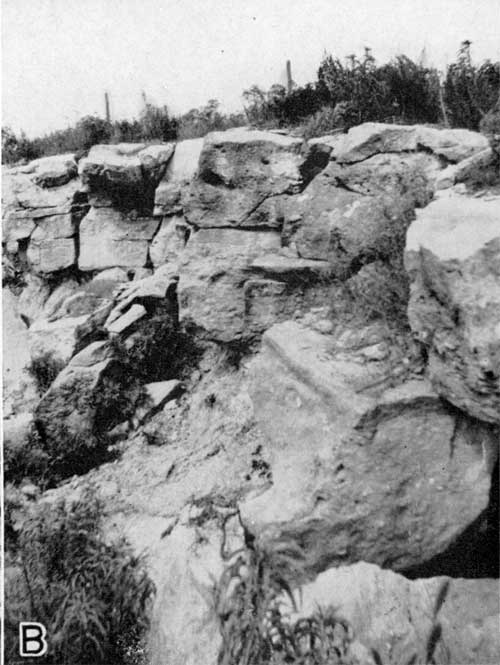
Many springs issue beneath the massive ledge, and along the hills it is everywhere marked by a line of shrubs forming a fringe that an be seen for many miles. Close observation removes any likelihood of confusing the Cottonwood limestone with any other layer in this part of Kansas. Its distinguishing characters are the massive ledge of uniform thickness, the silicified nodules, and the abundance of fusulinids, Pseudofuslina emaciata, chiefly in the upper part.
Distribution--The Cottonwood limestone is easily traced in the Flint Hills south of Kansas River and east of Manhattan. At Manhattan it lies near the top of the hills and is a part of the natural beauty of Sunset Park in the western part of the city. It lies slightly above the word Manhattan formed in concrete on Blue Mount in the northeast corner of the city and it forms the second bench on K Hill (Mount Prospect). The line of outcrop is a tortuous one extending several miles from Manhattan up Kansas and Big Blue rivers and their tributaries, and the upper part of the member is exposed west of Big Blue river in the extreme northeastern part of Riley County.
Detailed sections--The Cottonwood limestone is described under section numbered 44, 47, 48, 50, and 57 at the end of this report.
Florena shale ember
For many years the upper surface of the Cottonwood limestone was regarded as the base of a formational unit called Garrison shale. The base of the Wreford limestone marked the top of the formation. Prosser (1902, pp. 712-713), who named these strata as a formation, divided them into two very unequal parts, which he called Florena and Neosho, The former is the lower and is 2 to 13 feet thick; the latter is about 130 feet thick. The type exposure for the lower unit, Florena shale, is a quarry near Florena on Big Blue river. The terms Garrison and Neosho are no longer employed in Kansas stratigraphic nomenclature.
The Florena member of the Beattie limestone is known entirely across Kansas and into Nebraska and Oklahoma. It is not well exposed in many places in the two counties discussed here, but nevertheless it is known to be persistent in its characters.
Lithologic Character and Thickness-- Riley and Geary counties the Florena member is a gray argillaceous shale not more than 10 feet thick and generally less. It contains myriads of the little brachiopods, Chonetes granulifera, but few other fossils. Judging from the best exposures, the fossils seem to be limited to the lower part, their zone of abundance extending perhaps not ore than 2 feet above the base. In one exposure the shells were not seen but their seeming absence may be due to poor exposure of the lower part of the member. In several places on grass-covered slopes the abundance of the fossils can be detected, and in small ravines on the Flint Hills slopes they are everywhere present just above the Cottonwood limestone. Road cuts make excellent exposures where the perfectly preserved little shells can be, collected in great quantity. Observations elsewhere in the state have revealed that this member is one of the most persistent stratigraphic units. Its fauna is widespread, for the zone of abundance of Chonetes can be followed quite across the state. Farther south in Kansas, in Cowley and Elk counties, the variety of fossils is greater, and most of the Permian Pelecypods and brachiopods are included. In those counties and in Greenwood County Kansas, the Florena shale is remarkable for the presence of excellently preserved complete specimens of a small trilobite.
Morrill Limestone member
The Morrill limestone was named by Condra (1927, p. 234) when he described and named several other units of the former Garrison formation. The type exposure is near Morrill, Brown county, Kansas. This unit, which is inconspicuous In northern Kansas, becomes more noticeable in the southern part of the state. According to Bass (personal communication), it is more conspicuous than the Cottonwood limestone in Cowley County.
Lithologic Character and Thickness--Although in many places it is concealed under grass-grown slopes, wherever it is exposed this limestone exhibits lithologic characteristics that are remarkably persistent. It is brownish gray and it contains many calcite crystals. It weathers into a mass of irregularly pitted, granular brown limestone without apparent bedding, and the openings that produce the pitted appearance are partly filled with crystalline calcite. Although it is hard, it is not resistent to weathering, and nearly everywhere on the Flint Hills slopes it is covered by sod except where exposed artificially or cut by ravines. Generally a thickness of about 3 feet or less is visible, but this may be somewhat reduced by leaching. Weathered, isolated outcrops or blocks or floats are not unlike parts of the Neva limestone.
Distribution--In the two counties Morrill limestone can best be seen about 10 feet above the Cottonwood limestone in road cuts. Its distribution is approximately the same as that of the Cottonwood limestone.
Detailed sections--The Morrill limestone is included in sections numbered 47, 50, and 57 at the end of this paper.
Stearns shale
The shale between the easily identified Morrill limestone below and the Eiss limestone above was named Stearns shale as a unit of the old Garrison formation by Condra (1927, p. 234), the type exposure being situated near Stearns School near Humboldt, Neb. Strata in this interval are now recognized by the Kansas Geological Survey as comprising a formation.
Lithologic Character and Thickness--Like other shale units, the Stearns formation is rarely well exposed in Riley and Geary counties. Where best exposed, it is seen to consist of about 20 feet of gray shale, seemingly barren of fossils. Locally it is believed to contain thin beds of limestone, but this may not be true, as the limestone may be part of the overlying Eiss limestone.
Distribution--The stearns shale formation is distributed in the same area as are the Cottonwood and Eiss limestones.
Detailed sections--For sections including the Stearns shale see numbers 47, 50, 57 and 68 at the end of this report.
Bader Limestone
The Kansas Geological Survey recognizes the Bader limestone as a formation. It contains the Eiss limestone, Hooser shale, and Middleburg limestone, units that were named by Condra as member of the old Garrison formation. The type exposure is near Bader, in Chase county, Kansas.
Eiss limestone member
The Eiss limestone was named by Condra (1927, pp. 233-234), from exposures on the Eiss farm about eight miles south of Humboldt, Neb.
In Riley and Geary counties the Eiss limestone forms the first outstanding bench above the Cottonwood limestone, and throughout the area its physiographic expression rivals or locally surpasses that of the resisitant Cottonwood beds. it seems strange that this prominent limestone should have received so little attention while the Cottonwood was receiving so much. Perhaps the economic use of the Cottonwood, involving extensive quarrying, brought it to the attention of geologists.
Lithologic Character and Thickness--For many miles south and southeast of Manhattan and north along the west valley wall of Big Blue river the line of outcrop of the Eiss limestone is marked by blocks of white, pitted, partly silicified limestone. The blocks are commonly about 1.5 feet thick, 2 feet wide, and 3 feet long. In this area the Eiss limestone consists of three parts: lower limestone beds, gray, thinly bedded, altogether about 20 inches thick; about 30 inches of gray shale; and at the top slightly less than 3 feet of limestone, the upper part of which is very resistant, crops out prominently and is the source of the weathered blocks. pitted surfaces, which are more strongly developed along joint planes than along bedding planes, are characteristic, and weathered blocks are commonly chalky in appearance. The Eiss limestone is more noticeable south of the Kansas River, but nowhere does it lack topographic expression. its oine of outcrop lack the persistent fringe of shrubs that marks that of the Cottonwood 30 feet lower in the slopes.
Distribution--the Eiss limestone is readily traced along the slopes of the Flint Hills east and southeast of Manhattan, and up Big Blue and Kansas rivers and their tributaries.
Detailed sections--the Eiss limestone is included in sections number 47, 49, 50, 57, and 68 at the end of this report.
Hooser shale and Middleburg limestone members
The term Hooser shale has been applied by Condra and Upp (1931p.20) to the shale unit above the Eiss limestone and below the Middleburg limestone, which they have found to be persistent over a wide area. Previously Condra (1927, pp. 233-234) had named the strata form the Eiss limestone to the Sabetha (now Crouse), the Easly Creek shale. The Hooser shale is the lower unit of the Easly Creek as first defined. Later Condra and Upp (1931, pp. 19-20) redefined the Easly Creek to include only the upper part of the unit as first defined, i.e. the strata between the Middleburg limestone and the Crouse (formerly Sabetha)
In Riley and Geary counties the rock between the Eiss limestone and the Sabetha limestone, which has been correlated with the Crouse of Oklahoma, is exposed in only few places, but in some of the Flint Hills slopes a limestone above the Eiss and below the Crouse limestone produces a bench; the same limestone is exposed in a few road cuts, and it has been identified by the Nebraska geologists as the Middleburg limestone. The underlying shale is therefore correlated with the Hooser shale.
The type exposure of the Hooser shale is near the town of Hooser in Cowley County, Kansas, and that, of the Middleburg limestone near Middleburg School in Richardson county, Nebraska.
Lithologic Character and Thickness--Where best exposed the Hooser shale in this area is about 6 feet thick and is green and gray. The colors are believed to be characteristic. In the few good exposures in this part of Kansas, the Middleburg limestone, which lies about 6 feet above the top of the Eiss limestone, is divided into two parts, separated by about 6 inches of dark or black shale. The lower limestone bed is dark at the top, but is mostly yellow and the thickness is about 3 feet. The upper limestone is more variable from exposure to exposure, ranging from a yellowish-brown limestone to a red and green brecciated limestone. The thickness of the upper bed is about seven inches. According to Condra and Upp, this unit at the type exposure consists of an upper bed 16 inches thick, an underlying bed 18 inches thick, containing many small high-spired gastropods; and a shale bed 6-12 inches thick underlain by 2 or 3 inches of dark limestone. In Riley County there is a thin limestone bed containing myriads of similar gastropods, but the bed is believed to lie a few feet above the top of the strata that are referred to the Middleburg limestone. Similar gastropod-bearing limestone is to be seen at many places high in the Flint, Hills, especially in southeastern Riley County. F. M. Swain (personal communication) has found small gastropods in several thin limestones within the Council Grove beds in the Cottonwood river region.
Distribution--The Hooser shale and Middleburg limestones are nearly coexistent along the line of outcrop with the Eiss limestone below them.
Detailed sections--For sections in which the Hooser shale and Middleburg limestone are described see numbers 49, 57, and 68 at the end of this report.
Easly Creek shale
The Kansas Geological Survey recognizes the Easly Creek shale, as redefined by Condra and Upp, as a formational unit. the name was first applied by Condra to a larger unit but later he and Upp redefined the term to include strata between the Middleburg limestone below and the Crouse limestone above (Condra and Upp, 1931).
Lithologic Character and Thickness--In Riley and Geary counties the shale in this interval is predominately gray and green, but contains local bands of chocolate-colored material above and of yellow and red below. Myriads of small, high-spired gastropods locally characterize a thin bed of limestone, which may not be continuous. the thickness of the Easly Creek shale ranges between 15 and 20 feet.
Distribution--The Easly creek shale formation in the Flint Hills slopes can be traced for many miles and can be recognized because of tis position between its limiting limestones, which in turn can be easily recognized because of their position with reference to the well-known Cottonwood and Wreford limestones.
Detailed sections--For sections including the Easly Creek shale see number 32, 49, 57, and 68 at the end of this report.
Crouse limestone
Condra (1935, pp. 4, 6) employed the term Bigelow limestone As comprising three units previously named, in ascending order: (1) Sabetha limestone (Crouse limestone), (2) Blue Rapids shale, and (3) Funston limestone. Moore (1936a, fig. 4, 1). 12 and 1-940, fig. 16, 1). 44) used the name in the same way. The Bigelow, limestone thus included strata between the Easly Creek shale and Speiser shale. The Bigelow limestone was named from Bigelow, Marshall county, Kansas.
To be consistent with the classification applied to strata above and below them, these beds should be divided into three formations. This reasoning is based on the observation that the Blue Rapids shale is a comparatively thick unit of varicolored clastic material separating two limestones. In accordance with the present state of knowledge of cyclic deposition (Jewett, 1933; Elias, 1934) it corresponds genetically to the Roca, Eskridge, Stearns, and Easly Creek shales below it and to the Speiser shale above. It may be true that the limestones below and above the Blue Rapids shale are not so divisible as are other limestones in this part of the geologic column to which formational rank is assigned, but the Funston limestone comprises more than one limestone bed, and the Crouse limestone seems to be regionally divisible into three or more units. It is therefore proposed the Bigelow be dropped as a stratigraphic term and that Crouse limestone, Blue Rapids shale, and Funston limestone be recognized as formations. the Director of the Kansas Geological Survey concurs in this opinion (Moore, R.C., personal communication).
Condra (1927, p. 234) named the Sabetha limestone as a member of the Garrison formation and selected a type exposure near Sabetha, Nemaha County, Kansas, but later Condra and Upp (1931, p.21) found that the Sabetha limestone is the same as the Crouse limestone in Osage County, Oklahoma.
Lithologic Character and Thickness--in Riley and Geary counties the chief characteristic of the Crouse limestone is the platy structure of the upper part, which is manifest in all weathered exposures. The member is somewhat massive in the middle part, and it is granular and has a sandy appearance throughout. the color ranges through grays and browns. Fossil fragments are common, but well preserved specimens are almost lacking. Owing to the pronounced weathering of all exposures, the true thickness is hard to measure, but probably averages ten feet and is believed not to deviate greatly from that amount. From descriptions of the Crouse limestone in Oklahoma and southern kansas it is evident that the lithology changes greatly along the strike of the beds. In the counties discussed in this report the member makes a prominent bench, but is not so expressive as the Cottonwood and Eiss limestones.
Distribution--Like other units in this part of the geologic section, the Crouse limestone is present below the Wreford limestone beds and above the Cottonwood limestone throughout a large area in the Flint Hills. Its float is easily recognized along the slopes.
Detailed sections--Number 10, 49, 57, 66, and 68 of the stratigraphic sections at the end of this report give detailed descriptions of the Crouse limestone.
Blue Rapids shale
In Riley and Geary counties the strata between the top of the Crouse limestone and the base of the Wreford formation are divided into five easily recognizable units. These units are persistent over the entire area in which I studied the outcrops and I have seen them as far south as Greenwood County, Kansas. Condra (1927, p. 234) called the strata in the entire interval Speiser shale. Later he and Upp (1931, pp. 22-24) divided these beds into three parts: (1) Blue Rapids shale, (2) Funston limestone and (3) Speiser shale. The Crouse limestone, Blue Rapids shale, and Funston limestone were grouped as the Bigelow limestone formation. The type exposure of the Blue Rapids shale is near Blue Rapids shale is near Blue Rapids, Marshall county, Kansas, 8 miles north of Riley County.
Lithologic Character and Thickness--The Blue Rapids shale is well exposed in a few places. It is mostly gray although locally it contains some bands of red material. A thin unfossiliferous limestone bed is locally present in the lower part of the member. The thickness ranges between 20 and 30 feet.
Distribution--The Blue Rapids shale is mostly concealed under grass-covered slopes in the Flint Hills, but its position is revealed by the limestone outcrops and terraces between the bold outcrops of Eiss and Wreford limestone.
Detailed sections--For sections of the Blue Rapids shale see numbers 10, 32, 49, 57, 66, and 68 at the end of this report.
Funston limestone
Condra and Upp (1931, p. 23) chose an exposure within the area discussed in this report as the type for this limestone, which they believed to be persistent over a wide area. The type exposure is described as being "in bluffs of Kansas River valley, south of Funston Kansas," but the exact location is not stated. The type exposure is described as follows:
- limestone, gray, massive fossiliferous, 1' 6"
- shale, badly covered, greenish-gray, argillaceous, about 1'
- limestone, gray, massive, fossiliferous, 1' 6"
- shale, greenish 6"-1'
- limestone, medium dark gray, massive, blocky, sandy at places, 3'
Lithologic Character and Thickness--Throughout the area of outcrop in the two counties the thickness of this member varies and averages probably slightly more than 5 feet. Generally less distinct limestone beds overlie and underlie the more persistent one; they are perhaps included in the Funston limestone at its type exposure, but they are very lenticular. If these lenticular beds are included, the formation has irregular boundaries that are not stratigraphic horizons. The limestone that mainly compresses the unit is somewhat massive, but somewhat powdery, and is light in color and locally resemble an oolite.
Distribution--Like other units in the old Funston limestone crops out in only a narrow area limited by more resistant limestones above and below it. The Funston limestone commonly forms a terrace on the slopes below the more boldly outcropping Threemile limestone in the base of the Wreford formation.
Detailed sections--The Funston limestone is described in detail in sections 10, 32, 42, 49, 57, 66, and 68 at the end of this report.
Speiser shale
The rock between the Funston limestone and the base of the Wreford formation was called Speiser shale by Condra and Upp (1931, p. 23) when they redefined the term. The, term Speiser had formerly been applied by Condra (11927, p. 234) to the strata between the Sabetha (now Crouse) limestone and the base of the Wreford formation. The Speiser shale, now recognized as a formation, has its type exposure in Speiser township in Richardson county, Nebraska.
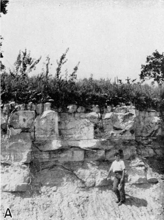
Lithologic Character and Thickness--There are three persistent units within the Speiser formation. They are indicated in table 2 as unnamed units. The lower is generally about 14 feet thick and comprises varicolored materials, grays, reds, greens, and purples being noticeable. The middle part of this lower unit includes brightly colored zones and the upper and lower parts are commonly gray. The upper part is very fossiliferous. Moore recently found fish and amphibian remains in these beds. The colored beds are partly or well exposed in many places below the overlying limestone unit. The second unit of the Speiser formation, a thin limestone, was studied in numerous exposures in the two counties. In fact wherever the Threemile limestone at the base of the Wreford formation is exposed one may expect to see this limestone bed. I have seen it as far south as sec. 27, T. 27 S., R. 8 E., in Greenwood County, Kansas, more than 80 miles south of Geary County. In this place and at places farther northward the thickness and lithology of the member are almost the same as they are in Riley and Geary counties. For many miles this unit separates the underlying varicolored shale beds from the gray and yellow shale of the third or upper unit. This limestone bed is generally less than 1 foot thick and is barren of fossils except for a few brachiopods. In lithology it varies somewhat, but is generally gray and crystalline. It represents the limestone member or vary calcareous shale that constitutes the units lying in between the varicolored shares and the fossiliferous shares in a typical rhythmic cycle of sedimentation as described by me (Jewett, 1933, pp. 137-140). The upper part of the Speiser shale formation is gray or yellow, fossiliferous, and generally less than 3 feet thick. The shale is well bedded and somewhat flaky. Common fossils of the unit are Productids, Derbyia sp., Composita sp., and a few bryozoa.
Distribution--Wherever the lower part of the Wreford formation is exposed above the valley floors the Speiser shale is present. In many places, such as road cuts and stream banks, the brightly colored shales of the lower unit and the thin, persistent limestone are visible. Plate 14A shows a characteristic exposure.
Plate 14A--A characteristic exposure of the upper part of the Speiser shale and the basal part of the Wreford limestone. The limestone under the boy's hand is a persistant one in the Speiser shale; west wall of the Big Blue river valley in northeastern Riley County.
Detailed sections--Sections 2, 10, 11, 32, 42, 49, 57, 59, 66, 68, 69, and 70 at the end of this report give a detailed description of the Speiser shale.
Prev Page--Admire Group || Next Page--Chase Group
Kansas Geological Survey, Geology of Riley and Geary Counties
Web version Nov. 2000. Original publication date Dec. 1941.
Comments to webadmin@kgs.ku.edu
The URL for this page is http://www.kgs.ku.edu/General/Geology/Riley/strat03b.html