![]()
Prev Page—Contents || Next Page—Geography
Introduction
Purpose and Scope of the Investigation
An investigation of the geology and ground-water resources was begun in Reno County in the summer of 1949 by the United States Geological Survey and the State Geological Survey of Kansas, with the cooperation of the Division of Sanitation of the Kansas State Board of Health and the Division of Water Resources of the Kansas State Board of Agriculture.
Ground water is a principal natural resource of Reno County. At the present rate of withdrawal, the danger of seriously depleting the ground-water supply in Reno County is very slight. But an adequate understanding is needed of the quantity and quality of the available supply, and of measures necessary to safeguard it so that water supplies for rapidly increasing municipal, industrial, and agricultural uses can be developed in an orderly fashion.
Location and Extent of the Area
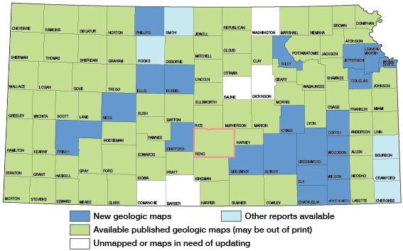
Reno County, in south-central Kansas, is bounded on the north by Rice and McPherson counties, on the west by Stafford and Pratt counties, on the south by Kingman County, and on the east by Harvey and Sedgwick counties. The county comprises 35 townships and contains about 1,255 square miles (Fig. 1).
Figure 1—Index map of Kansas showing area described in this report and areas covered by other geologic maps, as of Feb. 2001. For additional information, the KGS Geologic Maps of Kansas Page.
A detailed study of the geology and ground-water resources of Reno County has not been made previously. Brief references to the geology and ground water of parts of the county have been made in several reports, however. Haworth (1897) discussed the regional geology and ground water of western Kansas including Reno County. In 1913 Haworth discussed ground water in Reno County in a report on well waters in Kansas. Lohman (1942) discussed the availability of ground water in the Arkansas River valley below Hutchinson and in the buried McPherson channel north and west of Halstead. The ground water in Reno County was discussed by Lohman and others (1942) in a report on ground water available for national defense industries. Williams (1946) discussed the geology and ground water in the vicinity of Hutchinson, and Williams and Lohman (1949) discussed the geology and ground water of a part of Reno County in a report on the geology and ground-water resources of a part of south-central Kansas. Fent (1950) described the geology and ground-water resources of Rice County, and Latta (1950) described the geology and ground-water resources of Barton and Stafford counties.
Methods of Investigation
Field work was begun in Reno County in June 1949 and continued until December 1949. Additional field work was done during the spring of 1950. Data were collected on 241 wells including the depth of the well and the depth to water level in the well (P1. 2). Data concerning well yields and water-bearing materials were obtained from well owners. The stage of the Arkansas River was measured at 42 points along the river to aid in preparing the water-table contour map (P1. 1). Samples of water were collected from 152 wells (154 samples) and 22 points (22 samples) along the streams and were analyzed by Howard Stoltenberg, Chemist, in the Water and Sewage Laboratory of the Kansas State Board of Health.
Forty-nine test holes were drilled in the county to determine the thickness and character of the Quaternary deposits. The test holes were drilled with the hydraulic-rotary drilling machine owned by the State Geological Survey and operated by W. T. Connor and Max Yazza. Drill cuttings were collected in the field and later examined microscopically in the laboratory. The altitudes of measuring points of the wells and test holes were determined by means of a plane-table and alidade by Rex Huff and Virgil Young.
Highway maps prepared by the State Highway Commission of Kansas were used in the field for mapping and were used in the office as base maps in preparing Plates 1 and 2. The roads were corrected and the drainage of Reno County was delineated from aerial photographs obtained from the Agricultural Adjustment Administration, United States Department of Agriculture. The locations of wells within the section, shown on Plate 2, were determined by means of an odometer.
Well-numbering System
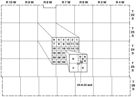
The well and test-hole numbers used in this report give the location of wells and test holes according to the General Land Office surveys and according to the following formula: township, range, section, quarter section, and quarter-quarter section. If two or more wells are in a 40-acre tract, they are numbered serially according to the order in which they were inventoried. The quarter sections and the quarter-quarter sections are designated a, b, c, or d in a counterclockwise direction beginning in the northeast quarter of the section. An example of the well-numbering system is given in Figure 2.
Figure 2.—Outline map of Sedgwick County, Kansas, illustrating the well-numbering system used in this report. Location is Section 22, Township 23 South, Range 8 West, showing the method of dividing sections into quarter sections, quarter-quarter sections, and quarter-quarter-quarter sections.
Acknowledgments
Thanks and appreciation are expressed to the many residents who supplied information on their wells and aided in collecting field data. Special acknowledgment is made to the officials of the cities who furnished information regarding city water supplies and to officials of the Hutchinson Water Company who provided information on the Hutchinson water supply. Acknowledgment is made to the drillers who supplied information and logs on wells and test holes in the county.
The manuscript of this report has been reviewed by members of the U. S. Geological Survey and the State Geological Survey of Kansas; by R. V. Smrha, Chief Engineer, and George S. Knapp, Engineer, of the Division of Water Resources of the Kansas State Board of Agriculture; and by Dwight F. Metzler, Director, and Willard O. Hilton, Geologist, of the Division of Sanitation of the Kansas State Board of Health.
Prev Page—Contents || Next Page—Geography
Kansas Geological Survey, Geology
Comments to webadmin@kgs.ku.edu
Web version Feb. 2001. Original publication date Aug. 1956.
URL=http://www.kgs.ku.edu/General/Geology/Reno/intro.html