![]()
Prev Page--Geography || Next Page--Ground-water Occurrence, Recharge, Discharge
Geology
Summary of Stratigraphy
[Note: The geologic classification and nomenclature of this report follow the usage of the State Geological Survey of Kansas and differ somewhat from those used by the U. S. Geological Survey.]
The rocks that crop out in Rawlins County are sedimentary in origin, Late Cretaceous (Gulfian), Pliocene, and Pleistocene in age, and most are unconsolidated.
The Pierre shale (Cretaceous), the oldest formation exposed in Rawlins County, crops out in only a few small areas of the county where younger beds have been eroded away. The Pierre shale underlies all of Rawlins County.
The Ogallala formation (Tertiary) overlies the Pierre shale in much of Rawlins County. Locally, erosion has removed all the Ogallala formation, and the Pierre shale is exposed.
Large upland areas of the county are blanketed by wind-blown silt (loess) of the Sanborn formation (Pleistocene). Several of the streams that cross the county have eroded into the Pierre shale and have then deposited sand, gravel, and silt, some now in terrace positions and some as alluvium on the present valley floors.
The areal extent of the geologic formations is shown on the geologic map (Pl. 1). Cross sections in Figures 4 and 5 show the general relation and extent of the formations. The character and ground-water supply of the formations in the county are described briefly in the generalized section (Table 2) and in more detail in the section on geologic formations and their water-bearing properties.
Figure 4--Geologic cross sections in Rawlins County along lines A-A', B-B', and C-C'. A larger version of this figure is available.
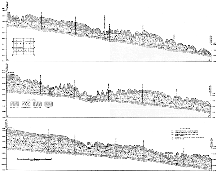
Figure 5--Geologic cross sections in Rawlins County along lines D-D', E-E', and F-F'. A larger version of this figure is available.
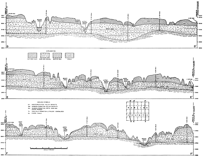
Table 2--Generalized section of the surficial geologic formations in Rawlins County, Kansas. The classification is that of the State Geological Survey of Kansas.
| System | Series | Stage | Formation | Member | Thickness (feet) |
Physical character | Water supply |
|---|---|---|---|---|---|---|---|
| Quaternary | Pleistocene | Wisconsinan and Recent |
Undifferentiated low terrace deposits (includes Alluvium) | 0-50 | Sand, gravel, silt, and clay along stream valleys. Locally, very coarse gravel in the lower part. | Yields moderate to large supplies of moderately hard water to wells along the major streams; small supplies in tributary valleys. | |
| Wisconsinan and Illinoian |
Sanborn formation |
Bignell silt member |
0-10 | Massive, well-sorted silt, light yellow-gray to tan, Blankets the uplands in some places. | Above the water table; yields no water to wells. | ||
| Peoria silt member |
0-75 | Massive well-sorted silt. light yellow-gray. Brady soil at top. Underlies uplands and slopes. | Above the water table in most places; generally does not yield water to wells. | ||||
| Loveland silt member |
0-30 | Massive silt, reddish-tan to tan. | Generally above the water table; does not yield water to wells. | ||||
| Crete sand and gravel member |
0-45 | Well-sorted sand, gravel, and silt. | Yields moderate to large quantities of water to wells. | ||||
| Kansan | Meade formation |
Sappa and Grand Island members |
0-10 | Volcanic ash (Pearlette), silt, sand, and gravel. Recognized in Rawlins County only where volcanic ash is present. Occurs as high terrace remnants in a few places in central and west-central Rawlins County. | Above the water table; does not yield water to wells. | ||
| Tertiary | Pliocene | Ogallala formation |
Kimball, Ash Hollow, and Valentine members |
0-280 | Sand, gravel, silt (partly cemented by calcium carbonate), impure limestone, volcanic ash, clay, and opaline sandstone. | Yields moderate to large quantities of water to wells. | |
| Cretaceous | Gulfian | Pierre shale |
400-1200 | Black to deep-brown and gray shale. Locally, contains bentonitic beds and selenite crystals. | Does not yield water to wells. |
Geologic History and Geomorphology
Paleozoic Era
Paleozoic rocks do not crop out in Rawlins County and are too deeply buried to be economically important other than as possible producers of oil or gas. Pre-Cambrian rocks, which have been found at depths ranging from about 4,500 feet to 5,250 feet in tests for oil and gas, are overlain by about 2,600 feet of Paleozoic sedimentary rocks. Throughout much of Paleozoic time the area was alternately submerged and elevated. Marine sediments that were deposited when the surface was below sea level were eroded during periods of emergence. Only a few hundred feet of Paleozoic rocks older than Mississippian age are reported in the subsurface of Rawlins County.
Mississippian, Pennsylvanian, and lower Permian rocks are mostly of marine origin, but toward the end of the Paleozoic era, nonmarine sediments and evaporites were deposited in greater quantities indicating a progressive emergence of the area.
Mesozoic Era
The sea withdrew from the area by the close of Paleozoic time and erosion was the dominant geologic process during much of early Mesozoic time. No deposits of Triassic age have been identified in the subsurface of the area. If Triassic beds were deposited, they subsequently were removed by erosion.
About 175 feet of rocks of probable Jurassic age (tentatively correlated with the Morrison formation) are known in the subsurface of Rawlins County. An erosion interval followed the deposition of these rocks; the area was probably above sea level during late Jurassic and early Cretaceous time. The area was again submerged during later Cretaceous time. The Dakota formation probably was deposited at or near sea level, and the overlying marine sediments were deposited in the deep late Cretaceous sea. Cretaceous rocks have a total thickness of about 2,000 feet in Rawlins County.
Cenozoic Era
Tertiary Period
During much of Tertiary time, the area was subjected to erosion, and the surface cut on the Cretaceous rocks became an eastward-sloping plain of low relief. In Pliocene time, streams originating in the Rocky Mountains shifted back and forth as they crossed the area, and spread a thick blanket of alluvial material (the Ogallala formation) on the eroded Cretaceous surface. At the close of Tertiary time the Ogallala surface was a nearly flat plain containing, according to some geologists, many fresh-water lakes in which the "Algal limestone", which caps the Ogallala formation, was formed.
Quaternary Period
A stream pattern that probably closely resembled the present drainage of Rawlins County began to form and to cut into the unconsolidated Ogallala sediments early in Pleistocene time. No deposits of Nebraskan age have been identified in Rawlins County, but by Kansan time the major streams were well established and alluvial deposits (Meade formation) of Kansan age occur as high-terrace remnants along several streams in the county. By Illinoian time the streams had cut to a lower level and stream deposits of that age (Crete sand and gravel member) were deposited about 30 to 40 feet lower than the Meade formation.
Late in the Pleistocene period a thick mantle of wind-transported silt (loess) was deposited over the area. This silt, which was picked up by the wind from the flood-plains of major rivers, was not deposited in one continuous period, but in three stages of deposition separated by soil-forming intervals. These three loess phases and the Crete sand and gravel member constitute the Sanborn formation.
The topography of the area since Sanborn deposition has been greatly modified by erosion and slumping. During and since late Wisconsinan time the streams have alluviated their valleys.
Prev Page--Geography || Next Page--Ground-water Occurrence, Recharge, Discharge
Kansas Geological Survey, Geology
Placed on web Nov. 17, 2008; originally published Dec. 1956.
Comments to webadmin@kgs.ku.edu
The URL for this page is http://www.kgs.ku.edu/General/Geology/Rawlins/04_geol.html