![]()
Prev Page--Contents || Next Page--Geography
Introduction
Purpose and Scope of the Investigation
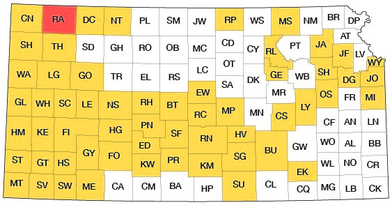
A program of investigation of the ground-water resources of Kansas was started in 1937 by the State Geological Survey of Kansas and the United States Geological Survey, in cooperation with the Division of Sanitation of the Kansas State Board of Health, and the Division of Water Resources of the Kansas State Board of Agriculture. The purpose of this program is to survey county areas and major stream valleys or irrigation districts to determine the availability of ground-water supplies. The present status of investigations resulting from this program is shown in Figure 1.
Figure 1--Index map of Kansas showing area described in this report and areas covered by other online geologic reports, as of Nov. 2008. For additional information, please visit the KGS Geologic Maps of Kansas Page.
As a part of this program, an investigation of the geology and ground-water resources of Rawlins County was begun in June 1952. Ground water is one of the most important mineral resources in Rawlins County; all supplies of irrigation, domestic, and public water and most supplies of stock water are obtained from wells. Irrigation with ground water is increasing rapidly in Rawlins County, and a series of dry years during times of relatively high prices for agricultural products would stimulate further the drilling of irrigation wells in the county. This investigation was made to determine the present utilization of ground water in the county, the depth of ground water below the land surface, the distribution and thickness of water-bearing materials beneath the surface, the chemical character of the ground water, and many other pertinent facts.
Previous Investigations
Papers by Haworth (1897, 1897a, 1913) discussed the geology and water resources of western Kansas. Johnson (1901, 1902), in his report on the utilization of the Southern High Plains, made special reference to the source, availability, and use of ground water in western Kansas, and Darton (1905) made a study of the geology and ground-water resources of the Central Great Plains. Elias (1931), in a report on the geology of Wallace County, described in detail most of the geologic formations that crop out in Rawlins County.
A description of the geology and ground-water resources of Rawlins and Decatur Counties was published by the State Geological Survey in 1937 (Elias, 1937). In 1940 Moore and others prepared a generalized report on the ground-water resources of the state. Investigations of the geology and ground-water resources of adjacent counties include Cheyenne County (Prescott, 1952), Sherman County (Prescott, 1953), Thomas County (Frye, 1945), Sheridan County (Bayne, 1956), and Decatur County (Biegler, in preparation). Beck and McCormack (1951) mapped the areal geology of Rawlins County and discussed the outcropping geologic formations in relation to their uses as construction materials.
Methods of Investigation
The field work upon which this report is based was done during the summer of 1952 and during a few days in the spring of 1953. The 226 wells and springs listed in Table 7 were inventoried and data pertaining to them obtained during this time. The depth to water level below the land surface and the total depth of most of the wells were measured with a steel tape.
Geologic mapping in the field was done on aerial photographs from field observations and stereoscopic study of the photographs. The geologic mapping was later transferred from the aerial photographs to a base map prepared by Bernita K. Mansfield from a county map prepared by the Soil Conservation Service. The illustrations were drafted in final form by Woodrow W. Wilson.
The character of the material overlying the Cretaceous bedrock surface was determined by drilling 31 test holes at strategic points in the county. These test holes were drilled with the portable hydraulic-rotary drilling machine owned by the State Geological Survey of Kansas and operated by William T. Connor and Norman W. Biegler. Samples of the well cuttings were collected and studied in the field by Biegler and logs of the test holes were prepared. These samples were later studied in the office under a binocular microscope. The altitudes of the ground surface at the test holes and of the measuring points of the wells were determined by Woodrow W. Wilson and Edwin Rhine by the use of a plane table and alidade.
Samples of water were collected from 18 wells; the samples were analyzed in the Water and Sewage Laboratory of the State Board of Health at Lawrence by Howard A. Stoltenberg, chemist. Analyses of three city supplies, on file with the State Board of Health, are included in this report.
Well-numbering System
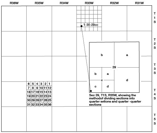
In this report, wells and test holes are numbered according to their location as given by the General Land Office system of land classification. The component parts of a well number are the township number, the range number, the section number, and lower-case letters to indicate the subdivisions of the section. The first letter denotes the quarter section; the second letter denotes the 40-acre tract; and the third letter, if used, indicates the 10-acre tract. The 160-acre, 40-acre, and 10-acre tracts are designated a, b, c, or d in a counterclockwise direction, beginning in the northeast quarter. If two or more wells are inventoried within the same 10-acre tract, the wells are numbered serially according to the order in which they were inventoried. An example of the well-numbering system is given in Figure 2.
Figure 2--Map of Rawlins County illustrating the well-numbering system used in this report.
Acknowledgments
Appreciation is expressed to the many residents of Rawlins County who supplied information and aided in the collection of field data. Special thanks are extended to the officials of the cities in Rawlins County for data on municipal water supplies.
The manuscript for this report has been reviewed critically by several members of the Federal and State Geological Surveys; by Robert Smrha, Chief Engineer, and George S. Knapp, Engineer, Division of Water Resources, Kansas State Board of Agriculture; and by Dwight Metzler, Director, and Willard Hilton, Geologist, Division of Sanitation, Kansas State Board of Health.
Prev Page--Contents || Next Page--Geography
Kansas Geological Survey, Geology
Placed on web Nov. 17, 2008; originally published Dec. 1956.
Comments to webadmin@kgs.ku.edu
The URL for this page is http://www.kgs.ku.edu/General/Geology/Rawlins/02_intro.html