![]()
Prev Page--The Water Table || Next Page--Discharge
Ground Water, continued
Ground-water Recharge
Recharge is the addition of water to the ground-water reservoir, and may be accomplished in several different ways. The underground reservoir beneath Morton County seems to be recharged by local rainfall within the county, by influent seepage from ephemeral streams, and by subsurface inflow from areas to the west of the county. The amount of annual ground-water recharge is approximately equal to the amount of annual natural ground-water discharge plus the amount of water that is withdrawn annually from wells without permanently lowering the water table.
Recharge from Local Rainfall
The average annual precipitation in Morton County is only 18 inches, but probably only a small percentage of this amount reaches the ground-water reservoir. Of the total precipitation, part is lost by evaporation into the air, part leaves the county as runoff in the streams, and part is used by growing plants (transpiration). The remainder may percolate downward to the zone of saturation and become ground water.
The amount of water lost by evaporation in any area depends upon the precipitation, temperature, humidity, vegetative cover, depth to the water table, and the length of time the processes of evaporation have access to the moisture. In Morton County most of the annual precipitation falls as rain in May, June, July, and August, and the climate during these months is characterized by high temperatures and low humidity. Therefore probably a large proportion of the annual precipitation in Morton County is lost by direct evaporation into the atmosphere.
The vegetation in this area consumes considerable soil water by transpiration, especially in May and June when it is most abundant.
A large part of the precipitation in this area falls as torrential rains. When such rains fall upon steep slopes, such as those along Cimarron River and some of its tributaries, the water runs off rapidly into the streams, allowing but little opportunity for absorption of water by the soil. Most of the land in the county is relatively flat or slopes very gently, however, hence the runoff over most of the county is relatively small. Vegetation also reduces runoff, but during much of the year the land in Morton County is relatively barren of vegetation. Modern methods of terracing and contouring of farm land tend to reduce the runoff, and, therefore, may increase the rate of recharge to the soil and to the ground-water reservoir.
Other things being equal, the percentage of water that is absorbed by the soil and becomes available as recharge depends upon the character of the soil and of the underlying material through which the water must pass en route to the zone of saturation.
The soils in the loess-covered areas north of the river are compact and transmit water very slowly, but the sandy soils in the dune-sand area are porous and absorb considerable water. The soils developed on the Ogallala formation are also porous and absorb water readily in places where the slopes are not great.
After passing through the soil zone the water percolates downward until it meets a relatively impervious bed of clay or caliche. It may then move laterally along the dip of the impervious bed until it reaches a pervious zone or fracture that permits it to continue its downward movement. In some places where such impermeable beds are widespread, some water may remain in a perched ground-water reservoir above the normal water table.
The effect of the surficial geology upon the recharge is discussed below under the principal formations that crop out over appreciable areas in Morton County.
Ogallala areas--About one-fourth of the area north of Cimarron River and small areas south of the river are underlain by the silt, sand and gravel of the Ogallala formation and overlying undifferentiated Pleistocene deposits (pl. 1). The soils developed from these materials are mostly sandy and porous but locally they may be calcareous, compact, and relatively impervious. The slope on most of the outcrops ranges from 2 to 5 percent, but it exceeds 10 percent along the north side of the Cimarron valley. The broad ground-water ridge shown on plate 1 north of the river indicates that the Ogallala formation probably is recharged to some extent by rainfall, although there is another possible explanation for this ridge (p. 35).
Dune-sand areas--Most of the area south of the river is underlain by dune sand and may be divided into two subareas based upon the type of soil and the topography. The first is the dune area just south of the river, which has a typical sand-dune topography and soil. The slope generally ranges from 2 to 5 percent but in some places may exceed 10 percent. Such steep slopes are very favorable to runoff. The sand-dune area, however, has many undrained basins in which water collects and percolates into the soil. The loose, porous, and permeable nature of the soil and the many undrained basins make the area favorable for recharge of the underlying Ogallala formation, and it is likely that considerable rainwater percolates downward to the zone of saturation.
The second sand dune area is south of the first, extending nearly to the Kansas-Oklahoma line, and is characterized by gentle slopes and a more compact soil. The slope averages less than 2 percent and the soils are comprised of loamy sands, fine sands, sandy loams, and fine sandy loams. The subsoils are heavier but are also sandy. This area has few if any undrained basins, but the permeable soils and gentle slopes favor the absorption of rainfall. This area probably contributes considerable water to the ground-water reservoir.
Loess areas--Deposits of wind-blown loess cover about three-fourths of the area north of Cimarron River and a small area along the Morton-Texas county line in southeastern Morton County (pl. 1). The soils that develop from loess are heavy and dark and consist of top soils of loams, clay loams, and silty clay loams and heavy clay subsoils that in places are very calcareous. The loess soils hold moisture well, but they absorb water very slowly. According to the soil map by Joel (1937), more than 95 percent of the upland loess area in the north half of the county has a slope of less than 2 percent. In spite of the gentle slope, the torrential nature of the rainfall together with the nearly impermeable character of the soil causes much of the water to be lost by runoff. The loss of water by runoff in such flat areas can be greatly reduced by contour farming. The loess soils are so thick and become so dry after long dry periods that most of the water that is not lost by runoff or evaporation is absorbed by the soil. It is probable that very little moisture that falls on the loess areas ever reaches the ground-water reservoir.
Recharge from Streams
The ridge on the ground-water table north of Cimarron River (pl. 1) may be caused in part by recharge of the ground-water reservoir from streams. North Fork of Cimarron River and its tributaries are ephemeral streams that lie above the water table. The land adjacent to these streams is moderately steep, so that much of the precipitation runs off into the streams. In some places where the channel is sandy and is underlain by permeable material, water may percolate downward to the zone of saturation. The Cimarron River valley has been cut into the zone of saturation, and hence it receives water from the ground-water reservoir rather than contributes water to it.
Recharge from Adjacent Areas
Ogallala formation--A large part of Baca County, Colorado, is underlain by the Ogallala formation (and associated Pleistocene deposits) and probably serves as a catchment area for part of the ground water that moves eastward into Morton County. The east-ward slope of the water table in Morton County, as shown by the contour lines on plate 1, indicates that much of the water is coming from the direction of Baca County. The Ogallala formation and Pleistocene deposits in Baca County, unlike those in Morton County, are not covered by loess except in the eastern part of the county and in other small isolated areas. The soils in this county are more sandy and the slopes are almost as gentle as those in Morton County. Although the rainfall in Baca County is about the same as in Morton County the area of the Ogallala exposed is so large (several hundred square miles) that probably a large amount of water is taken up by the Ogallala formation and eventually finds its way into Morton County. In the southeastern part of Baca County, along Cimarron River, the sand dunes also serve as a catchment area for recharge of the Ogallala formation.
Cockrum sandstone--The Cockrum sandstone crops out in Colorado in a large area in the eastern half of Las Animas county, in southwestern Baca County, and in eastern Baca County along Sand arroyo and Bear creek and its tributaries. The sandstone dips eastward toward Kansas at the rate of about 20 feet to the mile. Over much of this area the topography is fairly flat and the soil very pervious, so that a large amount of water may enter the stone and move eastward down the dip of the strata into Morton County, as illustrated in figure 5.
Figure 5--Generalized east-west cross section from the Rocky Mountains, through Colorado, into Morton County, Kansas.
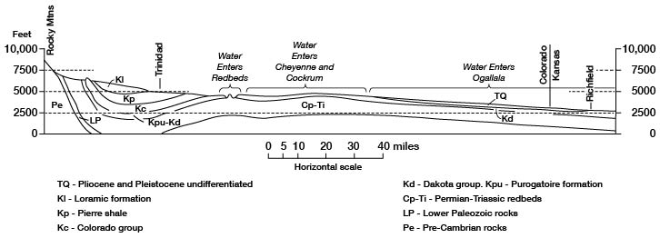
Near the middle of the county the ground water moves eastward from the Cockrum sandstone into the Ogallala formation, as shown on the water-table contour map (pl. 1) by the change from a steep to a gentle slope of the water table in the northeastern part of the county Much of the recharge of the Cockrum sandstone from outside the county thus enters the Ogallala formation.
Cheyenne sandstone--The Cheyenne sandstone which yields water to wells in northwestern Morton County, probably derives its water in the same manner as the Cockrum sandstone. The Cheyenne sandstone is the lower part of the Dakota group which crops out in many small areas along Purgatoire river, Rule creek and their tributaries. These areas of outcrop are principally in northern Las Animas county, northwestern Baca County southwestern Bent county and southeastern Otero county, Colorado. The overlying Kiowa shale is relatively impermeable and prevents recharge of the Cheyenne from the Cockrum sandstone or the Ogallala formation.
Redbeds--The recharge of the redbeds is discussed in part in the section on artesian wells. The age of the redbeds in Morton County is uncertain and the redbeds in the valleys of Purgatoire, Chaquaco, and Rule creeks have been called variously Permian or Triassic. The rainfall in this area is scant and the area of outcrop is relatively small, so the recharge of the redbeds also is probably small. Moreover, the waters must move more than 100 miles to reach Morton
In summary it may be said that ground water in the Ogallala formation is probably recharged mostly from the dune-sand area south of Cimarron River, from the outcrop area of Ogallala in Baca County, Colorado, and from the ephemeral streams and Ogallala outcrops north of Cimarron River in Morton County. The recharge to the Cockrum comes principally from the outcrops of the Cockrum in southeastern Colorado.
Prev Page--The Water Table || Next Page--Discharge
Kansas Geological Survey, Morton County Geohydrology
Comments to webadmin@kgs.ku.edu
Web version Sept. 2004. Original publication date March 1942.
URL=http://www.kgs.ku.edu/General/Geology/Morton/06_gw3.html