![]()
Prev Page--General Geology || Next Page--The Water Table
Ground Water
Principles of Occurrence
The discussion of the principles governing the occurrence of ground water that is given here takes account of conditions in Morton County. Preparation of the discussion has been based chiefly on the authoritative and detailed treatment of the occurrence of ground water by Meinzer (1923), to which the reader is referred for more extended consideration. A general discussion of the principles of ground-water occurrence, with special reference to Kansas, has been published by Moore (1940).
The rocks that make up the outer crust of the earth are generally not entirely solid, but contain numerous openings, called voids or interstices, which may contain air, natural gas, oil, or water. The number, size, shape, and arrangement of the interstices in rocks depends upon the character of the rocks. The occurrence of water in any region is therefore determined by the geology.
The interstices or voids in rocks range in size from microscopic openings to the huge caverns found in some limestones. The open spaces are generally connected so that water may percolate from one to another, but in some rocks these open spaces are isolated and the water has little chance to percolate. In Morton County the rocks from which ground water is obtained are sandstones and poorly consolidated silts, sands, and gravels. Generally the sands and gravels of the Ogallala formation contain numerous interstices and water percolates freely through them, but locally these interstices may he filled with calcium carbonate or other material such as clay, which makes the rock almost impermeable. Much of the silt, sand, and gravel of the Ogallala formation is poorly sorted and the finer particles fill much of the space between the larger particles, thereby decreasing the amount of space available to ground water. The sandstones of the Permian, Triassic (?), and Dakota are cemented with iron oxide, calcium carbonate, or silicon dioxide. The cement occupies a part of the open spaces, but enough voids are left to carry some water.
The porosity of a rock is the percentage of the total volume of the rock that is occupied by the interstices. A rock is said to be saturated when all its interstices are filled with water or other liquid, and the porosity is then practically the percentage of the total volume of rock that is occupied by water.
The porosity of a rock determines only the amount of water a given rock can hold, not the amount it may yield to wells. Some rocks may be moderately porous and yet will not yield an appreciable amount of water to a well. The permeability of a rock is defined as its capacity for transmitting water under pressure and is measured by the rate at which it will transmit water through a given cross section under a given difference of pressure per unit of distance. A rock containing very small interstices may be very porous, but it would be difficult to force water through it, whereas a coarser-grained rock, although it may have less porosity, generally is much more permeable. Some water is held in rocks by the force of molecular attraction, which, in some fine-grained rocks, is sufficiently great to make the rock relatively impermeable.
Below a certain level in the earth's crust the permeable rocks generally are saturated with water and are said to be in the zone of saturation. The upper surface of the Zone of saturation is called the ground-water table or simply the water table. All the rocks above the water table are in the zone of aeration, which ordinarily consists of three parts: the belt of soil water, the intermediate or vadose zone, and the capillary fringe.
The belt of soil water lies just below the land surface and contains a small amount of water held by molecular attraction. The soil zone must first be saturated with water before any water can percolate downward to the water table. The thickness of the zone is dependent upon the character and thickness of the soil and upon the precipitation
The intermediate or vadose zone lies between the belt of soil water and the capillary fringe. The interstices in the rocks in this zone are generally filled with air but may contain water for a short time while it is moving downward from the belt of soil moisture to the ground-water table. The vadose zone may be absent in places, such as some river valleys where the water table is near the surface, or it may be several hundred feet thick, as in parts of Morton County.
The capillary fringe lies directly above the water table and is formed by water rising from the zone of saturation by capillary action. The water in the capillary fringe is not available to wells, which must be deepened to the zone of saturation before water will enter them. The capillary fringe may be absent in coarse sediments, where the capillary attraction is negligible, but may be as much as 8 feet thick in very fine-grained sediments.
Artesian Wells
The pressure head of water has been defined as the height that a column of water will rise in a tightly cased well that has no discharge. Ground water is said to have artesian, normal, or subnormal pressure head, according as its static level is above the upper surface of the zone of saturation, at this surface, or below this surface. Artesian water, therefore, may be defined as ground water that has artesian head.
In some of the rock formations of Morton County, strata of permeable rock, such as sandstone, alternate with less permeable beds, such as shale or siltstone. In this county the strata dip toward the east, so that water falling on the outcrop area of a permeable bed moves eastward down the dip between the confining layers of relatively impermeable material and saturates the permeable stratum. Under such conditions wells drilled to the water-bearing beds in Morton County may, and locally do, encounter water under artesian pressure, and in two areas this pressure is sufficient to cause them to flow.
About 50 years ago three flowing artesian wells were drilled in the vicinity of Richfield. Well 43 (pls. 4B, 5), on the E. C. Wilson farm in the SW1/4 sec. 16, T. 32 5., R. 41 W., reported to be 710 feet deep, flows at the rate of 20 gallons a minute from a stratum encountered at a depth of 637 feet. The initial flow of the well was reported by the drillers and by Coffey and Rice (1912, p. 101) to have been about 1,200 gallons a minute.
Plate 4B--Flowing artesian well (pl. 2, well 43) at Richfield (photo by H.A. Waite).
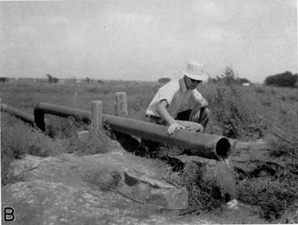
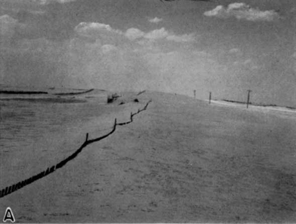
Plate 5A--Active sand dunes along Cimarron River near Rolla (photo by H.A. Waite).
Well 44, on the A.C. Dean farm in the SE1/4 sec. 28, T. 32 S., R 41 W., is reported to be 610 feet deep and to have had an initial flow of about 350 gallons a minute, but the present flow is only 7.5 gallons a minute. Well 45, on the C. W. Orth farm in the NE1/4 sec. 21, T. 32 5., R. 41 W., is reported to be 558 feet deep and it flows less than 1 gallon a minute. It is reported that its flow has always been small, even though the well stands at a lower altitude than wells 43 and 44.
The artesian water-bearing bed in the Richfield area is a red sandstone that lies nearly 350 feet below the base of the Cockrum sandstone and is probably Permian in age. Thick beds of red siltstones above and below the sandstone serve as the confining beds. The source area for the artesian water in Morton County is not definitely known. The nearest probable source is the outcrop area of redbeds along Purgatoire and Chaquaco rivers in the north-central part of Las Animas county, Colorado. The redbeds crop out near the crest of the Red Rocks dome and dip eastward into Morton County at the rate of about 20 feet to the mile. The redbeds exposed at Red Rocks dome are more than 375 feet thick and the part believed to be of Permian age (Parker, 1934, p. 44) is about 85 feet thick. The rocks consist predominantly of red sandstones and siltstones, but there are a few thin beds of limestone. The red-beds above Permian (the Dockum? and Exeter) are red sandstones and could readily serve as source rocks. Rainwater falling on sand- stones of the Dockum (?) and Exeter may move downward into Permian beds before striking impermeable strata and moving eastward along the dip of the strata.
The extent of the Richfield artesian area is not known, but if the reported data on the pressure head of well 43 are correct, there may be a fairly large area in which flowing artesian wells could be obtained. The three flowing wells that have been drilled in this area are in the valley of North Fork of Cimarron River and it is likely that the area of artesian flow is limited to a part of this valley.
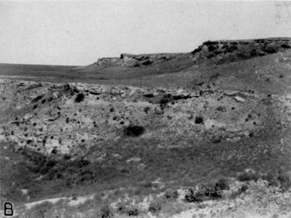
Flowing wells have been obtained also in the vicinity of Point Rock, particularly along Cimarron River (pl. 5B). A well drilled many years ago near Point Rock is reported to have had a small flow from a depth of 202 feet, and test well 7, drilled in 1939 at Point Rock about 80 feet north of the river in sec. 12, T. 34 S., R. 43 W., encountered a small artesian flow in redbeds at a depth of 200 feet. The Hydraulic Oil Company No. 1 Butts well, in the middle of sec. 22, T. 34 S., R. 43 W., found artesian water at a depth of 204 to 212 feet, but there are no data on the flow or the head of the well. A stock well beside Cimarron River in southeastern Baca county, Colorado, is reported to have had a moderate flow from a depth of about 100 feet, but no data are available as to the head of the water or the character of the water-bearing material. Parker (1911, pp. 143-144, 305-311) reported several artesian wells 90 to 105 feet deep along the Cimarron River valley south and southwest of Richfield, and states that an artesian flow was encountered in a well at the old town of Point of Rock about 4 miles northwest of Point Rock and near the southwest corner of sec. 23, T. 33 S., R. 43 W. The well was reported to yield a moderate quantity of "strong alkali" water. This well (86, pl. 2) is 254 feet deep and the water level on August 10, 1939, was 103 feet below the land surface. These wells are probably in an artesian area that extends many miles along Cimarron River. The water-bearing beds are the Triassic (?) or Permian redbeds and the source area is probably along Purgatoire and Chacuaco rivers in Las Animas county, Colorado.
Plate 5B--Point Rock, on the north side of the Cimarron valley near Elkhart; the lower beds are Triassic (?) redbeds and the upper beds are a part of the Ogallala formation (photo by H.A. Waite).
At several other places in Morton County, artesian water has been encountered by wells, but the pressure head was insufficient to pro-duce flowing wells. Well 140 (pl. 2) at Elkhart was drilled initially to a depth of 460 feet where it encountered strongly mineralized water in redbeds about 170 feet below the base of the Ogallala formation. The water rose within about 60 feet of the land surface. Some wells have failed to find a sufficient supply of water in the Cockrum sandstone in the northwestern part of the county and have been deepened to depths of 190 to 220 feet to get a supply from the under-lying Cheyenne sandstone. When the water is encountered in the Cheyenne sandstone it rises to a level 85 to 100 feet below the land surface. It is reported that a few wells in the Ogallala formation also have encountered water under artesian pressure. At a depth of 280 feet the municipal well at Rolla (92) found water that rose to a point about 200 feet below the land surface.
The artesian water at Richfield, Elkhart, and Point Rock is strongly mineralized. The water at Elkhart was found to be unfit for public use, so the well was plugged at a depth of 300 feet so that a supply of softer water could be obtained from the Ogallala formation. A sample of water from well 43 in the Richfield area contained 2,627 parts per million of total solids-mostly calcium and sulphate (table 5). The casing in well 43 is in poor condition and some of the mineralized water is escaping into and mixing with the softer water in the Cockrum sandstone.
Prev Page--General Geology || Next Page--The Water Table
Kansas Geological Survey, Morton County Geohydrology
Comments to webadmin@kgs.ku.edu
Web version Sept. 2004. Original publication date March 1942.
URL=http://www.kgs.ku.edu/General/Geology/Morton/06_gw.html