![]()
Prev Page--Contents || Next Page--Geography
Introduction
Purpose and Scope of Investigation
This report gives the results of a study of the geology and groundwater resources of Mitchell County, Kansas. The study was designed to determine the quantity and quality of ground water in the county and as a guide to future ground-water development. The only source of moderate supplies of ground water in Mitchell County is the alluvium of Solomon Valley and the adjacent alluvial terrace deposits. The Cretaceous bedrock formations in Mitchell County are not good aquifers, but because they are the only sources of ground water in the upland, consideration is given to these formations and their water-bearing properties.
This study was made as a part of the cooperative ground-water program begun in 1937 by the State Geological Survey of Kansas .and the United States Geological Survey, in cooperation with the Division of Sanitation of the Kansas State Board of Health and the Division of Water Resources of the Kansas State Board of Agriculture. The purpose of this program is to survey county areas and major stream valleys or irrigation districts to determine the availability of ground water.
Location and Extent of Area
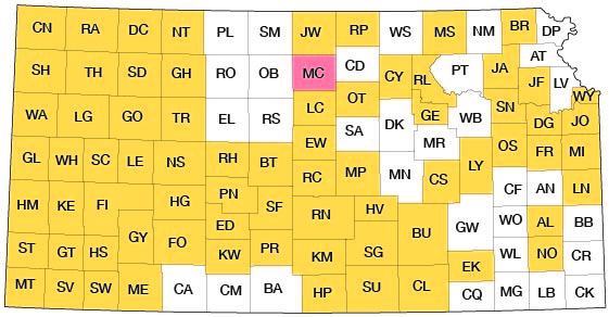
Mitchell County lies in the second tier of counties from the northern border of Kansas and midway between the east and west borders of the state (Fig. 1). The county extends 24 miles north and south and 30 miles east and west and has an area of about 720 square miles.
Figure 1--Index map of Kansas showing area described in this report and areas covered by other online geologic reports, as of June 2009. For additional information, please visit the KGS Geologic Maps of Kansas Page.
Previous Investigations
In 1897 Haworth discussed the physiography of western Kansas, and Williston (1897) described the stratigraphy of the Niobrara Formation of western Kansas. Darton (1905) included in his report a discussion of water wells in western Kansas. In 1913, Haworth briefly discussed the availability of ground water along the Solomon Valley. Landes (1930) described the geology of Mitchell and Osborne counties and included a brief discussion of groundwater resources. Moore and others (1940) discussed the general occurrence of ground water in Kansas; the general availability of ground water along the Solomon Valley was mentioned by Lohman and others (1942). Byrne, Johnson, and Bergman (1951) discussed construction-material resources in Mitchell County. Leonard (1952) described the geology and ground-water resources of North Fork Solomon Valley, which traverses the extreme northwestern part of Mitchell County.
Methods of Investigation
The writer spent 3 1/2 months during the summer and fall of 1954 and 2 months during the summer of 1955 in the field gathering the data upon which this report is based. The areal geology was mapped from field observations and stereoscopic study of aerial photographs obtained from the U. S. Department of Agriculture. County maps prepared by the State Highway Commission of Kansas at a scale of 1 inch to the mile were used to record field data.
Wells inventoried in the county total 310 (Table 17). Most wells were measured by means of a steel tape graduated to hundredths of a foot to determine the depth of the well and the depth to the water level. Measurements in a few wells could not be made, or were unreliable, and data on depth and water level for these wells were obtained from the owner or driller. Surface altitudes of most of the wells that were used as control for the water-table contours shown in the Solomon Valley on Plate 3 were interpolated from topographic quadrangle maps of the U. S. Geological Survey. Surface altitudes of wells for which topographic quadrangle maps were not available were determined by plane table and alidade.
Water samples were, collected from 48 typical wells in the county, and the chemical analyses of these samples are given in Table 5. In addition, analyses of municipal water supplies within the county were obtained from the State Board of Health. Water samples were collected from Solomon River at 3-mile intervals for partial analysis to determine points of contribution of chloride (Table 14). All samples were analyzed by Howard A. Stoltenberg, Chemist, in the Water and Sewage Laboratory of the Kansas State Board of Health.
Test holes in a line across the Solomon Valley were drilled by Leo Reavis and William Gellinger, using a hydraulic-rotary drilling machine of the State Geological Survey. Samples of drill cuttings were collected and examined in the field and were studied later in the laboratory. Logs of test holes drilled in a line across the Solomon Valley along the Mitchell-Cloud county line during the fall of 1953 (Bayne and Walters, 1959) and logs of test holes drilled in a line across North Fork Solomon Valley in western Mitchell County in the spring of 1946 (Leonard, 1952) are included in this report. In addition, logs of test holes drilled for the proposed Glen Elder dam project in the vicinity of Glen Elder by the Bureau of Reclamation in the fall of 1949, the winter of 1952, and the spring of 1954 are included. Cross sections were prepared from test-hole data; logs of the test holes are given at the end of the report.
Location and Well-numbering System
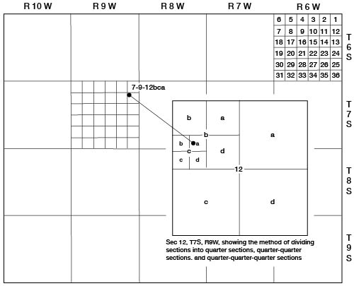
The location of wells, test holes, and local features in this report are designated according to General Land Office surveys in the following order: township, range, section, 160-acre tract within that section, 40-acre tract within that quarter section, and 10-acre tract within that quarter-quarter section. The 160-acre, 40-acre, and 10-acre tracts are designated a, b, c, or d in a counterclockwise direction beginning in the northeast quarter. For example, well 7-9-12bca is in the NE SW NW sec. 12, T. 7 S., R. 9 W. (Fig. 2).Figure 2--Diagram of Mitchell County illustrating location and well-numbering system used in this report.
Acknowledgments
Appreciation is expressed to the residents and municipal officials of Mitchell County who so kindly supplied information and gave assistance during the course of the field work. The manuscript of this report has been reviewed critically by several members of the Federal and State Geological Surveys; by Robert V. Smrha, Chief Engineer, and George S. Knapp, Engineer, Division of Water Resources, Kansas State Board of Agriculture; and by Dwight F. Metzler, Chief Engineer, and Willard O. Hilton, Geologist, Division of Sanitation, Kansas State Board of Health.
Prev Page--Contents || Next Page--Geography
Kansas Geological Survey, Geology
Placed on web June 16, 2009; originally published April 1959.
Comments to webadmin@kgs.ku.edu
The URL for this page is http://www.kgs.ku.edu/General/Geology/Mitchell/02_intro.html