![]()
Prev Page--Geology || Next Page--Ground water
Geologic Formations in Relation to Ground Water
Cretaceous System
Gulfian Series
Dakota Formation
Distribution and thickness--Although not exposed in Logan County, the Dakota formation underlies the area and has been penetrated in test wells drilled for oil and in one water well. It is the oldest formation known to yield water in Logan County. The closest outcrops of the Dakota formation are in southern Hamilton County, where the uppermost 25 or 30 feet is exposed (McLaughlin, 1943, p. 120) .
The gradational changes between the Dakota formation and the overlying Graneros shale and the underlying Kiowa shale and Cheyenne sandstone make definition of their exact boundaries difficult. The thickness of the Dakota probably averages about 300 feet. According to Landes and Keroher (1939, p. 24), the combined thickness of the Dakota formation, Kiowa shale, and Cheyenne sandstone ranges from 450 to 550 feet in Logan, Gove, and Trego Counties.
Character--The Dakota formation is composed mainly of variegated shale and lenticular sandstone beds. The sandstones are crossbedded and interfinger with the shale. McLaughlin (1943) found that in Hamilton County about 40 to 45 percent of the formation consists of clay, but the ratio of sandstone to shale varies from place to place. Only about one-fourth of the formation is sandstone in Ness and Hodgeman Counties (Moss, 1932, p. 32).
Water supply--The Dakota formation contains saturated sandstone that is a good aquifer. The sandstone penetrated in well 13-33-6bb (Pl. 6C) is about 40 feet thick, and there are other sandstones in the formation at greater depth. The pressure in the aquifer forced the water 500 feet above the top of the producing bed. The pressure is considerably less than normal fluid pressure expected at this depth, a fact suggesting that the artesian aquifer is being recharged at lower altitude or at a distance sufficient to result in a loss of head by friction within the reservoir itself, or both. The altitude of the water level in this well conforms to a piezometric surface based on data from other wells in the Dakota formation. Hydraulic gradient of this surface indicates movement of water to the north from an outcrop area in southern Hamilton County.
No aquifer tests were made on the Dakota formation, and the yield of the well drilled into the formation was not measured, hence the permeability of the formation is not known. Considering the nature of the material, which is fine to medium sand, and the thickness of the sandstone section, wells having moderately large yields probably could be developed in the formation.
Graneros Shale
Distribution and thickness--The Graneros shale is not exposed in Logan County but was penetrated in oil test holes and probably underlies the entire county. The nearest exposures of the Graneros shale are in the southern part of Hamilton County, where 60 to 65 feet of the formation is exposed (Bass, 1926, p. 72).
Character--The Graneros shale consists of noncalcareous marine shale ranging from dark gray to medium gray, but contains also a few thin beds or lenses of sandstone and sandy shale and some thin bentonite beds. The conformable contact between the Graneros shale and the underlying Dakota formation is not everywhere distinct, but probably is a transitional zone in which sandstones and shales of the Dakota formation grade upward into sandy shales of the Graneros. The top of the formation is marked by a sharp lithologic break between the noncalcareous Graneros shale and the overlying Greenhorn limestone.
Water supply--The Graneros shale is not a source of ground water for wells in the county.
Greenhorn Limestone
Distribution and thickness--The Greenhorn limestone underlies Logan County but does not crop out. The nearest outcrops are in Hamilton County, where the Greenhorn limestone is 132 feet thick, the contact with the Carlile shale being determined on the basis of fossils (Bass, 1926, p. 66). Landes and Keroher (1939, p. 24) reported the thickness of the Greenhorn limestone to be about 100 feet.
Character--The Greenhorn limestone consists of thin chalky and crystalline medium-gray limestones separated by thicker beds of medium-gray chalky shale that contain thin light-gray beds of bentonite. Limestone concretions are common in the shales in the upper part of the formation. The Greenhorn limestone grades upward into chalky beds of the Carlile shale; hence, there is no distinct lithologic break between the formations.
Water supply--The Greenhorn limestone is not a source of ground water in Logan County, and no wells are known to have been drilled into it for the purpose of producing water.
Carlile Shale
Distribution and thickness--The Carlile shale does not crop out in Logan County but underlies the county. The thickness ranges from 150 to 260 feet in Logan, Gove, and Trego Counties (Landes and Keroher, 1939, p. 23). The conformable contact of the shale with the overlying Fort Hays limestone member of the Niobrara formation is distinct.
Character--The Carlile shale contains two members, the Fairport chalky shale and the Blue Hill shale. The Fairport constitutes about the lower third of the formation and consists of thick beds of chalky shale alternating with thin beds of chalk or chalky limestone. Many hard concretions occur in the lower part of the member and few bentonite beds occur in the shale. The Blue Hill constitutes the upper two-thirds of the Carlile shale and consists of dark-gray noncalcareous shale, containing seams and crystals of gypsum, and in the upper part a zone of large septarian concretions.
The Codell sandstone is a sandy zone at the top of the Blue Hill shale member. In an exposure in southeastern Lane County (Prescott, 1951, p. 72) the Codell sandstone consists of about 2 feet of tan fine-grained sandstone and sandy shale grading downward into the shale of the Blue Hill shale member.
Water supply--The Carlile shale is a dense shale of low permeability containing the thin Codell sandstone at the top. The Codell may produce small quantities of water that is likely to be too mineralized even for livestock use.
Niobrara Formation
Distribution and thickness--The Niobrara formation is exposed extensively in Logan County (Pl. 1) where the formation is not mantled by Pleistocene deposits. Along Smoky Hill River and Chalk and Twin Butte Creeks, the Smoky Hill chalk member crops out as steep bluffs having meandering steep-walled canyons and pinnacles cut from the soft chalk by the action of water. Many of the exposures of the chalk cover hundreds of acres of winding canyons, barren rocky ridges, and buttes.
The examination of cuttings from test holes for oil and gas indicates that the maximum thickness of the Niobrara formation is about 690 feet in Logan County. Where Smoky Hill River has cut away much of the Smoky Hill chalk member in the eastern part of the county, the thickness is probably about 300 feet.
Character--The Niobrara formation consists chiefly of clayey, somewhat fissile chalk containing chalky limestone and bentonite seams. The Niobrara formation is divided into the Fort Hays limestone member below and the Smoky Hill chalk member above.
The Fort Hays limestone member is composed of thick beds of massive chalky limestone separated by thin beds of chalky shale. The member is exposed in Lane County (Prescott, 1951, p. 72). The contact of the Fort Hays limestone member and the underlying Carlile shale is marked by a distinct change from the dark-gray noncalcareous fissile shale of the Carlile to the massive light-colored limestone of the Fort Hays.
Conformably overlying the Fort Hays limestone member is the Smoky Hill chalk member, which consists of soft shaly chalk, massive in the upper part and thin-bedded and somewhat fissile in the lower part. The Smoky Hill chalk member is medium gray and weathers to colorful white, yellow, pink, and orange. Thin bentonite beds are common and can be traced many miles along the outcrop. Pyrite concretions are present throughout the member but are most common in certain persistent zones. Large discoidal soft reddish to yellowish-brown concretions of limonite and pyrite are arranged in indistinct disconnected layers in the upper and middle parts of the member. The upper contact is recognized by the abrupt change from the medium-gray chalk of the Niobrara formation to the dark-gray fissile noncalcareous Pierre shale.
The following measured sections indicate the character of the Niobrara formation in southern Logan County:
| Section of Smoky Hill chalk member of Niobrara formation on north side of cliff in SE sec. 16, T. 15 S., R. 34 W., measured September 10, 1954. | Thickness, feet |
||
|---|---|---|---|
| Cretaceous--Gulfian | |||
| Niobrara formation | |||
| Chalk, thick bedded, pale yellowish orange; contains many bentonite partings. Upper 10 feet is poorly exposed and littered with quartozse gravel | 66.0 | ||
| Bentonite | 0.2 | ||
| Chalk, thick bedded, pale yellowish orange | 18.5 | ||
| Bentonite | 0.5 | ||
| Chalk, fissile, grayish orange to reddish orange; contains some gray chalk | 18.0 | ||
| Bentonite | 0.1 | ||
| Chalk, gray | 0.5 | ||
| Bentonite | 0.1 | ||
| Chalk, fissile, gray; some ferruginous and pyrite concretions | 6.5 | ||
| Bentonite | 0.2 | ||
| Chalk, fissile, gray; contains abundant pyrite concretions superficially resembling walnuts. Ostrea are found in lower part | 28.5 | ||
| Bentonite | 0.1 | ||
| Chalk, fissile, gray; contains many discoidal ferrugunous concretions and pyrite concretions in upper part. Ostrea very abundant in persistent beds; contains a more resistant bed 7.5 feet above base | 12.0 | ||
| Bentonite | 0.1 | ||
| Chalk, fissile, gray | 0.6 | ||
| Bentonite | 0.1 | ||
| Chalk, fissile, light gray; contains many large discoidal ferreginous concretions | 6.0 | ||
| Chalk, thick bedded, fissile, gray; contains many ferruginous concretions and some small pyrite concretions. Fish scales and Ostrea are abundant | 4.5 | ||
| Total thickness measured | 162.5 | ||
| Section of Smoky Hill chalk member of Niobrara formation exposed in ravines and buttes in SW sec. 25, T. 14 S., R. 34 W., measured September 10, 1954. | Thickness, feet |
||
|---|---|---|---|
| Cretaceous--Gulfian | |||
| Niobrara formation | |||
| Chalk, fissile, gray | 2.0 | ||
| Bentonite | 0.1 | ||
| Chalk, fissile, gray; contains Ostrea in upper part | 8.5 | ||
| Bentonite | 0.1 | ||
| Chalk, fissile, gray; contains abundant Ostrea | 8.5 | ||
| Bentonite | 0.1 | ||
| Chalk, fissile, gray; contains Ostrea | 2.0 | ||
| Bentonite | 0.1 | ||
| Chalk, fissile, gray; contains very abundant Ostrea | 5.0 | ||
| Bentonite | 0.1 | ||
| Chalk, fissile, gray; contains very abundant Ostrea | 10.0 | ||
| Bentonite | 0.1 | ||
| Chalk, massive, containing a few partings, pale orange to white; weathers into tall pinnacles and buttes. Ostrea are fairly abundant and concentrated in layers | 27.5 | ||
| Total thickness measured | 64.1 | ||
| Section of Smoky Hill chalk member of Niobrara formation in ravine and on west side of cliff in SW sec. 17, T. 15 S., R. 34 W., measured September 6, 1954. | Thickness, feet |
||
|---|---|---|---|
| Cretaceous--Gulfian | |||
| Niobrara formation | |||
| Chalk, poorly exposed on slope, containing some chalk fragments, silicified chalk and quartz, and quartz pebbles | 5.5 | ||
| Chalk, thin bedded, fairly dense, pale to medium yellowish orange, layered | 11.0 | ||
| Chalk, massive, pale yellowish to reddish orange; weathers to rounded knobs and hollows | 6.0 | ||
| Chalk, blocky, friable, white | 0.3 | ||
| Chalk, thin bedded, fissile, layered white, pale yellow, and yellowish orange; some beds weather into miniature masonry-like blocky surfaces | 6.5 | ||
| Chalk, massive except for very thin shale partings, pale yellowish orange to grayish pink; contains a thin bentonite parting 2 feet above base | 3.0 | ||
| Bentonite, blocky, white and dark reddish brown | 0.3 | ||
| Chalk, massive, pale yellowish orange to grayish pink; contains Ostrea and fish teeth and scales; weathers to rough, rounded surfaces and forms a bench | 6.2 | ||
| Chalk, massive, white to pale yellowish orange; contains some fish teeth and scales | 4.0 | ||
| Chalk, fissile, layered white to orange; weathers to a recess between adjacent units | 0.2 | ||
| Chalk, massive, white to pale yellowish orange; contains abundant fish teeth and scales | 2.5 | ||
| Chalk, thick bedded, layered white to pale orange; contains bentonite partings at 1.5, 3.0, 4.5, and 7.0 feet above base | 7.0 | ||
| Chalk, thick bedded but locally weathering into fissile chalk, grayish pink to pale orange; contains thin bentonite seams. Ostrea are common | 20.5 | ||
| Chalk, thick bedded, fissile, layered pale orange to light gray; contains much coarsely crystalline gypsum as veins and seams. Ostrea are abundant | 17.0 | ||
| Chalk, fissile, medium gray; some ferruginous concretions and gypsiferous seams and veins | 4.5 | ||
| Bentonite, pale gray to brown | 0.2 | ||
| Chalk, fissile, light medium gray; contains thin bentonite seams | 4.3 | ||
| Chalk, fissile, medium light gray; gypsum and ferruginous concretions are common. Thin bentonite seams 5.5 and 6.0 feet above base | 20.0 | ||
| Chalk, fissile, medium light gray; contains some ferruginous concretions, prominent jointing, and a persistent bentonite seam 13 feet above base | 13.0 | ||
| Chalk, fissile, medium light gray; contains large discoidal ferruginous concretions and gypsum veins. Ostrea and fish teeth and scales are abundant | 11.5 | ||
| Chalk, fissile, medium light gray; contains abundant shark teeth, Ostrea in persistent layers, and seams of calcite and gypsum; top marked by persistent layer of pyrite concretions | 11.0 | ||
| Total thickness measured | 154.5 | ||
| Section of Smoky Hill chalk member of Niobrara formation exposed in ravine in NW sec. 13, T. 15 S., R. 35 W., measured September 9, 1954. | Thickness, feet |
||
|---|---|---|---|
| Cretaceous--Gulfian | |||
| Niobrara formation | |||
| Chalk, massive, pale yellowish orange | 4.0 | ||
| Bentonite | 0.2 | ||
| Chalk, thick bedded, containing thin shale partings, layered white to pale orange | 17.5 | ||
| Bentonite | 0.1 | ||
| Chalk, massive, layered white to pale yellowish orange | 4.0 | ||
| Bentonite | 0.1 | ||
| Chalk, massive, pale yellowish orange | 2.0 | ||
| Bentonite, light gray to dark brown | 0.3 | ||
| Chalk, fissile, pale yellowish orange; contains veins and seams of gypsum | 2.0 | ||
| Bentonite, light gray | 0.1 | ||
| Chalk, yellowish orange to grayish orange pink; contains many gypsum veins and seams. Ostrea are abundant | 5.0 | ||
| Bentonite | 0.1 | ||
| Chalk, thick bedded, pale yellowish orange; contains many gypsum veins. Ostrea are abundant | 5.5 | ||
| Chalk, gray; contains many relatively thick bentonite seams and gypsum veins | 15.0 | ||
| Bentonite | 0.1 | ||
| Chalk, gray | 0.3 | ||
| Bentonite | 0.2 | ||
| Chalk, gray | 1.0 | ||
| Bentonite | 0.1 | ||
| Chalk, fissile, light medium gray | 10.0 | ||
| Bentonite | 0.1 | ||
| Chalk, fissile, light medium gray | 3.0 | ||
| Bentonite | 0.1 | ||
| Chalk, fissile, light medium gray | 1.5 | ||
| Bentonite | 0.1 | ||
| Chalk, fissile, light medium gray | 0.6 | ||
| Bentonite | 0.2 | ||
| Chalk, fissile, light medium gray | 7.5 | ||
| Bentonite | 0.2 | ||
| Chalk, fissile, light medium gray | 1.5 | ||
| Bentonite | 0.1 | ||
| Chalk, fissile, light medium gray | 6.0 | ||
| Total thickness measured | 88.5 | ||
Insoluble residues, which were prepared from several samples of the chalk, constituted 40 to 60 percent of most samples. The large clay content of the chalk probably accounts for its fissile character upon weathering.
The Smoky Hill chalk member in Logan County has long been famous for the many vertebrate and invertebrate fossils it contains. Vertebrate fossils include bones of reptiles and dinosaurs and teeth and scales of fish. Sharks' teeth are especially abundant. The most abundant invertebrate fossils ire Inoceramus grandis, a large clam, and Ostrea congesta, a small oyster, which commonly occur as thick crusts and layers traceable over small distances. Foraminifera, chiefly Globigerina and Gumbelina, make up more than half the calcareous material of the chalk (Moss, 1932, p. 19). Fossil wood has been found in the formation. Williston (1897, p. 243) reported a fossil tree about 30 feet long discovered near Elkader. Prescott (1951, p. 74) reported a fossil tree trunk in Lane County about 6 feet long that had been altered to lignite. Waite (1947, p. 174) reported that a 3-inch coal bed was penetrated in a test hole drilled into the Niobrara formation in Scott County.
The chalk of the Niobrara formation formerly was used extensively as building stone, especially the massive layers of the upper part. The quarry industry is waning in Logan County, but a few quarries are still active. Much of the chalk is used as road fill where washouts are frequent.
Water supply--The Niobrara formation is relatively unimportant as a water-bearing formation in Logan County, but several wells in the county derive water from the Niobrara formation where other ground-water supplies are unavailable. The water contains much sulfate and other dissolved solids and is unfit for domestic use and irrigation, but can be used to water livestock.
The beds of shaly chalk are relatively impervious, and water is transmitted chiefly through fractures. A large dam was built in sec. 8, T. 13 S., R. 35 W., across a narrow draw between two bluff s of chalk of the Niobrara formation. A study of the rock on the downstream side of the dam showed much leakage of water through the joints. The Niobrara formation at this locality is dissected by joints associated with a fault about 150 feet downstream that trends approximately parallel to the dam (Pl. 6B).
The rapid movement of water through the joints indicates that the Niobrara formation where faulted could be utilized as a source of water for livestock use, particularly in draws cut into the Niobrara formation where ground-water supplies generally are thought to be insufficient. Study of the jointing and dip of the chalk may disclose a fault that, if intersected 20 or 30 feet below the bottom of a draw by a drilled well, will supply sufficient water for livestock use. Most of the faults mapped on Plate 1 are in areas to which livestock water is being hauled from Winona or Oakley.
Pierre Shale
Distribution and thickness--The Pierre shale conformably overlies the Niobrara formation, from which it can be readily distinguished by the noncalcareous nature and dark-gray color of the Pierre. The formation is unconformably overlain by Tertiary and Pleistocene strata. The contact is obscured in some localities by the fact that the Tertiary and Pleistocene clay and shale directly overlying the Pierre shale were derived principally from the clayey material of the older formation. The Pierre shale in Wallace County was studied by Elias (1931), who divided it into six members, of which only the Sharon Springs, Weskan, and Lake Creek are exposed in Logan County.
The Pierre shale underlies much of the nortnern and western parts of Logan County, but has been eroded away along the valleys of Smoky Hill River, Twin Butte Creek, and Chalk Creek. The formation is absent also in the northeastern corner of the county south of Chalk Creek, where the Ogallala formation, of Tertiary age, directly overlies the Niobrara formation. In Logan County the Pierre shale probably attains a maximum thickness of 300 feet in the northwestern part.
Character--The Pierre shale is a dark-gray fissile noncalcareous shale that occurs in massive beds between which are intercalated seams of bentonite, limonite, and crystalline gypsum. The shale contains many different types of concretions arranged in definite stratigraphic zones that can be used locally as key beds (Elias, 1931). The bentonite beds also have been used to correlate exposures of the Pierre shale in Wallace County (Elias, 1931) and in eastern Colorado (Dorrel, 1938). The Pierre shale is mapped as a single unit on Plate 1 because of the uniform hydrologic characteristics of the formation.
A part of the following stratigraphic section a few miles south of Wallace in Wallace County was studied and measured with the help of N. W. Biegler (Bradley and Johnson, 1957).
| Measured section of Pierre shale in sec. 7, T. 14 S., R. 38 W., Wallace County. | Thickness, feet |
||
|---|---|---|---|
| Cretaceous--Gulfian | |||
| Pierre shale (in contact with overlying Ogallala formation) | |||
| Shale, yellow and brown, mottled; limestone concretions near contact with overlying Ogallala formation; contains fish scales | 10.5 | ||
| Shale, gray, fissile, containing white powdery material in fractures; weathers light gray | 11.6 | ||
| Shale, gray and brown, fissile, containing lenticular silty limestone concretions having maximum diameter of about 7 inches | 1.0 | ||
| Shale, fissile, blue gray | 6.5 | ||
| Bentonite, yellow; contains limonitic shale partings | 0.5 | ||
| Shale, blue gray, containing lenticular limestone bodies as much as 0.5 foot thick and 3 to 6 feet across | 3.5 | ||
| Shale, blue gray, fissile, containing abundant bentonite stringers and, at the base, a persistent hard limonitic bed 0.5 inch thick | 10.2 | ||
| Shale, brown, limonitic, containing numerous limy concretions as much as 3 inches in diameter | 0.6 | ||
| Shale, blue gray, weathering yellow brown and earthy, fissile; bentonite stringers as much as 0.5 inch thick are common; contains fish scales and many gypsum crystals in platy aggregates | 29.0 | ||
| Total thickness measured | 73.4 | ||
The above section is comparable to the middle part of the Pierre shale described by Elias (1931). The following stratigraphic section including the Niobrara, Pierre, and Ogallala formations was measured in an exposure on Lone Butte south of Russell Springs (Pl. 8A).
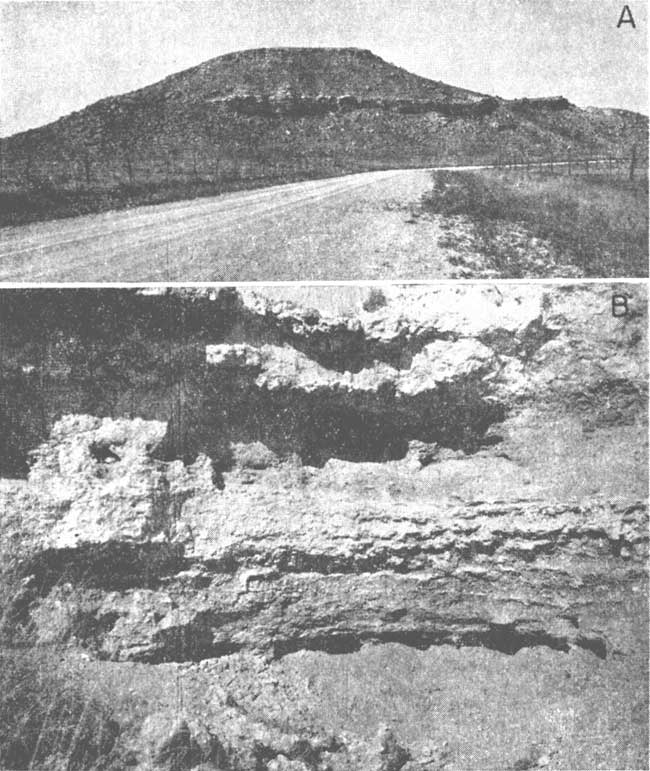
Plate 8--A, Lone Butte in sec. 4, T. 15 S., R. 35 W., and sec. 33, T. 14 S., B. 35 W. Niobrara formation is exposed from foot of hill to top of prominent cliff. Gentle slope above cliff is developed on Pierre shale. Butte is capped by sandstone of Ogallala formation. B, Exposure of Ogallala formation in sec. 31, T. 15 S., R. 32 W., showing reddish fine-grained sandstone facies.
| Section of Gulfian Series on east side of Lone Butte in SE sec. 33, T. 14 S., R. 35 W., measured September 9-10, 1954. | Thickness, feet |
||
|---|---|---|---|
| Tertiary--Pliocene | |||
| Ogallala formation | |||
| Limestone, silty, fine grained, calcareous, white; contains much siliceous material | 16.5 | ||
| Sandstone, conglomeratic, calcareous, white to grayish orange pink | 11.0 | ||
| Cretaceous--Gulfian | |||
| Pierre shale | |||
| Shale, clayey, fissile, noncalcareous, dark gray; contains some olive-green layers | 35.0 | ||
| Niobrara formation--Smoky Hill chalk member | |||
| Chalk, thin bedded to fissile, calcareous, white to reddish orange; contains some bentonite seams | 27.5 | ||
| Chalk, thick bedded to massive, resistant, white to pale orange; weathers to a blocky, masonry-like ledge | 11.5 | ||
| Bentonite, pale gray | 0.2 | ||
| Chalk, thick bedded to massive, gypsiferous, pale gray to orange; weathers to a rough, rounded surface; contains Inoceramus, Ostrea, fish scales, and some acicular unidentified fossils | 17.8 | ||
| Chalk, soft, pale orange; contains two thin bentonite seams | 0.5 | ||
| Chalk, thick bedded, pale orange; contains much gypsum in veins and seams. Where weathered the chalk resembles a fissile shale | 2.0 | ||
| Bentonite, pale gray and reddish brown | 0.7 | ||
| Chalk, pale orange, contains much gypsum and sparse Ostrea | 1.5 | ||
| Bentonite | 0.2 | ||
| Chalk, thick bedded, somewhat fissile when weathered, pale gray to pale orange; contains many gypsum veins and abundant Ostrea | 15.0 | ||
| Bentonite | 0.1 | ||
| Chalk, gray | 1.5 | ||
| Bentonite | 0.1 | ||
| Chalk, gray | 1.5 | ||
| Bentonite | 0.1 | ||
| Chalk, pink | 0.6 | ||
| Bentonite | 0.1 | ||
| Chalk, soft, fissile, grayish pink to gray; contains much gypsum in veins | 5.5 | ||
| Total thickness measured | 148.9 | ||
Water supply--No wells in Logan County derive water from the Pierre shale. Some water probably moves along joints and bedding planes, but the quantity is insufficient to supply wells.
Tertiary System
Pliocene Series
Ogallala Formation
Pre-Ogallala buried valleys--A mature drainage system was developed upon the Cretaceous rocks before deposition of the Ogallala formation. Determination of the width and depth of the principal valleys of that system is important in delineation of the areas of greatest saturated thickness of the Ogallala formation; consequently, the trend of the channels was explored by test drilling and by measurement of altitude of the Tertiary-Cretaceous contact where exposed at the edge of the upland plain.
The exploration revealed several channels in the northern upland, one of which is 100 to 150 feet deep and is particularly important in that it provides a medium for storage and transmission of ground water. This channel (Pl. 1) trends northeastward across the county from a point about 4 miles south of Winona and crosses the northern boundary of the county at Oakley. The width of the valley between the axes of the contiguous divides is 12 to 15 miles. The channel has been traced through Thomas County (Frye, 1945) and southern Sheridan County (Bayne, 1956) and eastward to the edge of the Tertiary beds through northern Trego County. The channel, if formerly present, has been eroded away in the western part of Logan County, but probably was once continuous with a pre-Ogallala channel 3 miles south of Sharon Springs in Wallace County. The channel forks, the two branches crossing the Colorado-Kansas line 8 and 14 miles respectively north of the Greeley-Wallace County line (Bradley and Johnson, 1957). The flow of the main drainage in pre-Ogallala time was northeastward in the northern part of Logan county and southeastward in the southern part of the county.
Distribution and thickness--The Ogallala formation is exposed along the valleys of Smoky Hill River and its tributaries and of Chalk and Twin Butte creeks. In the southeastern corner of the county the Ogallala formation crops out along Hell Creek, which flows into Smoky Hill River farther east in Gove County.
The tapered area of upland plain in the northern part of Logan County is underlain by the Ogallala formation. Areas between Smoky Hill River and Twin Butte Creek and between Twin Butte and Chalk creeks in the central and western part of the county also are underlain by the Ogallala formation. The Ogallala overlies the Niobrara formation under the upland south of Chalk Creek. Over most of the upland area the Ogallala formation is mantled by loess and by basal sand and gravel of the Sanborn Group of Pleistocene age, but it is exposed in a few places in the interior of the upland where streams have dissected the Pleistocene mantle, especially along Hackberry Creek in the eastern part of the county. The Ogallala formation caps isolated buttes in sec. 13 and 26, T. 12 S., R. 37 W., and in sec. 4, T. 15 S., R. 35 W. (Pl. 8A).
Where present, the Ogallala formation is thickest in the pre-Ogallala valleys and thinnest on the divides. A maximum thickness of 226 feet of Ogallala was penetrated in well 11-32-3bd1. The thickness of the Ogallala formation is nearly 200 feet in several other areas in Logan County.
Character--The Ogallala formation is composed chiefly of calcareous sandstone containing clay, silt, gravel, cobbles, and boulders. It is cemented by calcium carbonate to various degrees in different places.
The sandstone shows two distinct lithologic facies. One consists of coarse, poorly sorted sandstone or conglomerate, which is locally somewhat crossbedded and contains unevenly cemented beds that weather to rough benches and cliffs. Some beds are loosely cemented, but others are densely cemented with silica. Where not tightly cemented, the coarse conglomerate and conglomeratic sandstone of this facies are the most permeable water-bearing units in the county. The other facies (Pl. 8B) consists of a reddish fine-grained sandstone containing much clay and silt, calcareous nodules, and rootlike concretions. The red color of this facies seems to be derived from red clay that is intermixed with the silt and fine sand. Both sandstones are dominantly quartzose but contain feldspar and igneous rock fragments that are subangular to subrounded. The calcareous cement is white.
In some places the Ogallala formation is capped by a limestone referred to as the capping limestone by Smith (1940, p. 44-45). It is commonly massive and weathers to a knobby irregular surface. Elias (1931, p. 136-141) described similar rock in Wallace County and referred to it as algal limestone because of its concentrically "banded" structure. Waite (1947, p. 120-121) described this limestone in outcrops in Scott County where it is as much as 5 feet thick. The capping limestone is exposed on the south side of Chalk Creek in the southern part of Logan County and along Twin Butte Creek in the western part.
Thin beds of yellow or pale-red shale were penetrated in test holes and recognized in exposures. The shale beds are good marker beds, whereas the sandstones are extremely lenticular and show little lateral continuity.
Olive-green bentonitic shale exposed in sec. 7 and 13, T. 11 S., R. 37 W., probably is equivalent to the Woodhouse clay of Wallace County (Elias, 1931, p. 155-158). Whether this bentonitic shale is continuous with the persistent thin clay shales penetrated in test holes drilled in the Ogallala formation farther east is not known. The shale, however, is present also in the basal part of the Ogallala in Scott County (Waite, 1947, p. 119). In Logan County the shale overlies the Pierre shale, from which it can be distinguished readily by its green color.
The Ogallala formation is the chief aquifer of Logan County and is a source of sand and gravel used as road metal on many of the roads. Because the opal-cemented beds used for building stone in other counties in Kansas are not well developed in Logan County, none of the rock is quarried.
The following section of the Ogallala formation was measured and studied at an exposure in the southern part of Logan County.
| Section of Ogallala formation exposed on bluff east of Ladder Creek in SW SE sec. 31, T. 15 S., R. 32 W. | Thickness, feet |
||
|---|---|---|---|
| Interval at top of bluff covered by much Ogallala "float" | |||
| Tertiary--Pliocene | |||
| Ogallala formation | |||
| Sandstone, silty, fine grained, thick bedded, calcareous, grayish orange pink; contains lenticular beds of firmly cemented sandstone and loose sand | 11.0 | ||
| Sandstone, silty, fine to medium grained, calcareous, grayish orange pink; contains firmly cemented nodular zones. Poorly exposed | 16.5 | ||
| Sandstone, silty, fine to medium grained, calcareous, grayish orange pink; contains beds of firmly cemented sandstone and some siliceous nodules. Poorly exposed | 5.2 | ||
| Siltstone, calcareous, grayish orange pink; contains considerable sand, firmly cemented in places; weathers to typical knobby light-gray "mortar bed" covered with lichens | 7.5 | ||
| Siltstone, poorly sorted, calcareous, reddish orange; contains much sand and some gravel, and a weakly developed columnar structure | 5.5 | ||
| Siltstone, weakly cemented, calcareous, reddish orange; contains much sand and gravel, rootlike calcareous concretions, and large calcareous nodules | 7.9 | ||
| Siltstone, reddish orange; contains considerable fine sand and some concretions | 3.0 | ||
| Sandstone, fine to coarse grained, having pebbles more than 1 inch in diameter, and much silt, massive, unsorted, weakly cemented, calcareous, grayish orange pink; weathers to rounded knobs and hollows conspicuously without lichen growth. Celtis willistoni are common | 8.6 | ||
| Sandstone, medium to coarse grained, containing some silt and gravel, massive, vaguely crossbedded, moderately cemented except for firmly cemented bed at top, calcareous, grayish orange pink; contains balls of finely laminated red silty sand; Celtis willistoni are common | 8.7 | ||
| Sandstone, medium to coarse grained, containing considerable silt, firmly cemented, grayish orange pink; contains much siliceous material as cement and nodules | 1.2 | ||
| Shale, containing some silt, weakly cemented, reddish orange; contains shards of volcanic ash and rootlike concretions | 1.5 | ||
| Sandstone, medium to coarse grained, containing some gravel, moderately cemented, calcareous, pale grayish red; contains balls of red silt and clay | 1.0 | ||
| Siltstone, sandy, grayish red; contains specks of calcareous material | 0.5 | ||
| Sandstone, medium to coarse grained, calareous, grayish orange pink; contains pale-yellow calcareous clay nodules having a maximum diameter of 1 foot | 1.6 | ||
| Sandstone, medium to coarse grained, containing some fine, to medium gravel, moderately cemented, poorly sorted, calcareous, grayish orange pink; contains rootlike concretions and rugose nodules. This zone also contains pale-yellow calcareous clay nodules especially abundant in the upper part and commonly less than 2 inches in diameter | 6.1 | ||
| Sandstone, very conglomeratic, medium to coarse grained, unsorted, moderately cemented, calcareous, grayish orange pink | 14.7 | ||
| Covered interval of reddish sand, silt, and talus of the Ogallala | 21.8 | ||
| Cretaceous--Gulfian | |||
| Niobrara formation | |||
| Chalk, thick bedded, pale yellowish orange; weathers to a fissile chalk | 7.2 | ||
| Chalk, thick bedded, somewhat fissile, light medium gray | 3.8 | ||
| Chalk, massive, grayish pink to pale orange; contains a bentonite seam | 1.0 | ||
| Chalk, massive, fissile, light medium gray, contains prominent joints dipping about 60° S | 3.0 | ||
| Bentonite, light gray to brown | 0.3 | ||
| Chalk, fissile, light medium gray to pale orange | 3.0 | ||
| Total thickness measured | 140.6 | ||
Water supply--The Ogallala formation is the most important water-bearing formation in Logan County. All wells in the upland plain derive water from the Ogallala formation, and there is no difficulty in obtaining water for livestock and domestic use in the north upland area. The saturated thickness of the formation is as much as 142 feet and averages about 30 feet (Fig. 5). The thickest bearing materials are in the pre-Ogallala valleys.
Fig. 5--Map of Logan County showing saturated thickness of Ogallala formation.
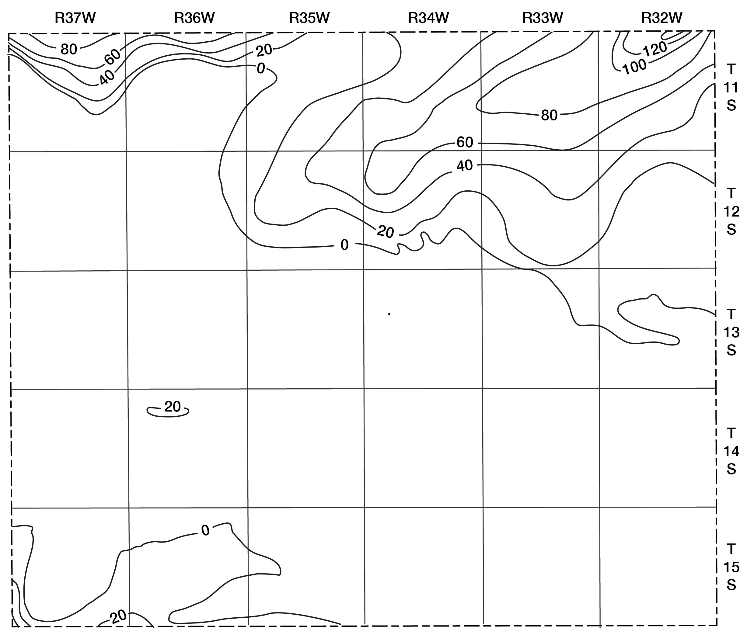
The aquifer tests using wells in the Ogallala formation in Logan County indicated coefficients of permeability ranging from about 230 to 1,000 gpd per square foot. The average coefficent of transmissibility divided by the average saturated thickness of the tested aquifer produced an average coefficient of permeability of 440 gpd per square foot, which is similar to the results of aquifer tests of the Ogallala formation in the Ladder Creek area (Bradley and Johnson, 1957).
Water-level fluctuations in wells measured periodically indicate that the water level in the Ogallala formation beneath the upland plain is not influenced by seasonal variations in precipitation or even by extreme differences between consecutive years. The long-term trends in precipitation seem to be reflected in the water levels after about a 3.5-year lag, although the length of record is too short to confirm this. Barometric effects in wells in the Ogallala formation have been observed throughout western Kansas where automatic water-level recorders are installed. A barometric effect indicates that the aquifer is confined by relatively less permeable beds and, hence, that the water is under artesian pressure. The artesian effect was confirmed in the aquifer tests.
Wells drilled in the Ogallala formation in Logan County yield as much as 630 gpm. In areas of thickest water-bearing materials, properly constructed wells probably could produce 1,000 gpm.
Quaternary System
Pleistocene Series
Meade Group
The name Meade formation has been applied by different authors to two different sequences of rocks. To preserve the name Meade it has been raised to group rank, the Meade Group including both the formations to which the name Meade has been applied. The deposits in Logan County are classified in the upper of the two formations, as they are believed to be of Kansan age.
Distribution and thickness--The known exposures of the Meade Group in Logan County are on the north side of the tributaries of Smoky Hill River, where the southward-flowing streams have cut through a "pediment" veneer. The exposures are higher in elevation than the later Pleistocene "pediments" but considerably lower than the edge of the upland plain. The Meade Group generally is mantled, and difficult to distinguish from deposits of the Sanborn Group. Some of the extensive sandy areas close to the river may be equivalent to the Meade Group.
The maximum thickness of the Meade Group observed in Logan County is 32 feet, measured in the NW sec. 13, T. 13 S., R. 35 W., but greater thicknesses probably occur. A test hole drilled in the NW sec. 6, T. 13 S., R. 33 W., penetrated 60 feet of yellow clay, which may represent the Meade at that place. Prescott (1951, p. 81) reported a thickness of 120 feet for the Meade in Lane County.
Character--The Meade Group consists mainly of clay, sandy silt, and fine sand, but the lower part is chiefly sand and gravel that was deposited as valley fill. Many of the pebbles were derived from the Niobrara formation. The upper formation of the Meade Group in Kansas is separated into two members, the lower Grand Island member, which consists mainly of sand and gravel, and the upper Sappa member, which consists of clay, fine sand, silt, and in some places the Pearlette volcanic ash (Frye, Swineford, and Leonard, 1948, p. 518-523). The ash is light gray to white, medium to fine grained, and friable (Pl. 5A). In exposures where the ash is missing, the Meade is difficult to distinguish from the slope deposits of the Sanborn Group, which have a similar origin. As the Meade is of minor significance hydrologically, no effort was made to correlate exposures of materials probably of the Meade Group by paleontological means. Unless the ash was present to identify it, the Meade was mapped on Plate 1 with the Sanborn Group. Much of the sand and gravel at a lower elevation mapped with the Sanborn Group may be equivalent to or derived from the Grand Island member.
In the following measured sections the Meade could be identified by the ash in or near the exposure.
| Section of Meade Group on east side of draw on Briggs Ranch in SW sec. 35, T. 13 S., R. 33 W., measured June 24, 1954. | Thickness, feet |
||
|---|---|---|---|
| Quaternary--Pleistocene | |||
| Sanborn Group (?) | |||
| Silt, somewhat sandy, reddish brown; grades from sand at base to light-gray silt above | 6.5 | ||
| Sand and gravel, silty, reddish brown; contains large quartz cobbles but few chalk fragments | 4.5 | ||
| Meade Group | |||
| Sand and gravel, containing considerable silt, pale yellowish orange; contains chalk pebbles of Niobrara formation | 5.5 | ||
| Ash, massive, friable, white; contains siliceous nodules; underlain by a thinly laminated pinkish-gray siliceous layer 2 inches thick | 5.5 | ||
| Clay, silty, thick bedded, dense, not fissile, pale yellowish orange | 12.0 | ||
| Sand and gravel, massive, calcareous, pale yellowish orange; composed of chalk pebbles and cobbles of Niobrara formation. Weathers to form a protruding ledge | 2.0 | ||
| Covered interval | |||
| Total thickness measured | 36.0 | ||
| Section of Meade Group on east side of draw at NW sec. 13, T. 13 S., R. 35 W., measured July 29, 1955. | Thickness, feet |
||
|---|---|---|---|
| Quaternary--Pleistocene | |||
| Sanborn Group (?) | |||
| Sand and gravel, loose, reddish brown | 4.0 | ||
| Meade Group | |||
| Clay and silt, very sandy, calcareous, grayish orange pink | 5.5 | ||
| Clay, calcareous, grayish red; contains white calcareous nodules | 5.5 | ||
| Clay, noncalcareous, light to medium gray | 4.5 | ||
| Clay, moderately compact, grayish orange pink; contains much coarse sand and silt | 4.0 | ||
| Sand and gravel, loosely cemented; contains much yellow silt | 16.5 | ||
| Covered interval | |||
| Total thickness measured | 40.0 | ||
Water supply--The Meade Group in Logan County is not an important aquifer. A few wells obtain domestic and livestock supplies from this formation on the higher "pediments." Some parts of this sequence may underlie the alluvium or late Wisconsinan terrace deposits along the major valleys and may produce water to a few wells.
Sanborn Group
Distribution and thickness--The Sanborn Group is composed chiefly of sand and gravel derived from the Ogallala formation and spread over that formation as a thin veneer over ridges, but thickening toward the major streams. The sand and gravel were mantled by loess probably blown from the north during early Wisconsinan time (Swineford and Frye, 1951). Because it mantles the older formations and has been only slightly dissected since it was deposited, the Sanborn Group is the most widely exposed geologic unit in Logan County.
The greatest thickness observed in the county is 82.5 feet in test hole 13-36-12aa (Pl. 4), which may include some sand and gravel of the Meade Group. The average thickness of the Sanborn Group on the uplands is about 20 feet.
Character--The Sanborn Group in Logan County consists chiefly of pale yellowish- gray silt of eolian origin and coarse colluvial sand and gravel at the base. The Sanborn Group has been divided into the following formations in ascending order: (1) Crete formation; (2) Loveland formation, commonly containing the buried Sangamon soil at the top; (3) early Wisconsinan terrace deposits; 4) Peoria formation, commonly containing the buried Brady soil at the top; (5) late Wisconsinan terrace deposits; and (6) the Bignell formation. The Loveland formation was not positively identified in Logan County although it may be represented by some thin sandy red silts overlying the Crete formation.
Deposits of the Crete formation are widespread throughout the county, and occur at the edges of "pediment" slopes along the major streams. In places the Crete is exposed in vertical bluffs where it is overlain by loess or slope deposits. The formation generally is mantled by various thicknesses of silt and either does not crop out or consists of poorly exposed sand and gravel at the base of a steep slope composed principally of loess. Outcrops of the Crete formation shown on Plate 1 do not represent its maximum extent.
The Peoria and Bignell formations form a mantle over most of Logan County. The silt is pale yellowish-gray calcareous clayey loess containing some fine sand and abundant fossil snails.
Terrace deposits of supposed Wisconsinan age flank the floodplains of the major streams and can be traced up even the smaller tributaries. The deposits closely resemble the silt of the Peora loess but are laminated in part.
Soil and rock affected by creep and sheetwash mantle the slopes. They consist chiefly of loess mixed with materials derived by erosion of the Tertiary and Cretaceous rocks. The slope deposits are continuous with the various formations of the Sanborn Group, are poorly exposed, and difficult to distinguish from the Sanborn Group. For these reasons the slope deposits, and perhaps some exposures of the Meade Group as well, have been mapped with the Sanborn Group on Plate 1.
The sand and gravel of the Crete formation have been used extensively as road metal and concrete aggregate; hence, this member was differentiated from the rest of the Sanborn Group. Most of the upland soils in Logan County were formed from the silts of the Sanborn Group.
Water supply--The Sanborn Group generally lies above the water table in the uplands, but probably yields water to the many wells on the dissected "pediment" flats. The alluvium in small draws may be underlain in part by the Sanborn Group, which may yield water to some of the wells in the draws. The Peoria formation is nearly everywhere above the water table and does not yield water to wells.
Dune Sand
Distribution and thickness--Dune sand is present on the high divides where the wind has stripped the loess cover and exposed the sandy layers. The sand and associated silt are drifted by the prevailing south winds into low mounds and ridges in the lee of low hills or escarpments on the north flanks of the ridges. Acccumulations of sand blown from Pleistocene deposits are present in sec. 32, T. 14 S., R. 32 W., and sec. 7, 8, and 27, T. 14 S., R. 33 W. The largest dune-sand area in the county is in sec. 18, T. 14 S., R. 33 W.
Sand from the Ogallala formation has been deposited as a north-trending elongate dune in sec. 30 and 31, T. 11 S., R. 37 W. This is the only dune accumulation of sand derived from the Ogallala formation that was observed in Logan County. It probably resulted because the Ogallala formation is loosely cemented in the northwestern part of the county, the local relief is pronounced, and the area is exposed to the south winds. The thickness of the material in Logan County has not been determined, but it probably does not exceed 20 feet.
Character--The dune sand in Logan County is composed chiefly of medium to fine quartz sand and silt. The soil zone is thin or absent, and attempts at cultivation have stripped the protective vegetative cover, allowing the upper surface to be subjected to renewed wind action.
Water supply--The deposits of dune sand in Logan County lie above the water table and are not known to yield water to wells. They readily absorb water from precipitation, however, and transmit a part of it downward to underlying strata.
Alluvium
Distribution and thickness--Alluvium was deposited in narrow belts along the streams. The alluvium attains its greatest width and thickness in the valley of Smoky Hill River, where in some places it is about a mile wide and about 35 feet thick in the deeper part of the valley.
Character--The alluvium in Logan County ranges from clay to coarse sand and gravel. The youngest deposits consist chiefly of sand, gravel, and silt deposited over the floodplain or in the channel of the stream (Pl. 5B). Beneath the surficial deposits are slightly older layers of sand and gravel of similar origin. The character of the alluvium in small tributaries is dependent upon the character of the rock into which particular valleys have been incised. The thick coarse alluvial deposits are confined to the major stream valleys.
Water supply--Alluvium is the chief aquifer beneath the flood plains and yields moderate to abundant supplies of water to wells. Although water from the alluvium is pumped chiefly by domestic and livestock wells, many irrigation wells have been developed in the alluvium of the Smoky Hill River valley.
Water levels in wells in the alluvium generally are within 20 feet of the surface and are affected by individual storms. In the smaller valleys many of the wells producing from these deposits become dry during periods of scanty rainfall. Much of the water in the alluvium is transpired by deep-rooted plants, causing a seasonal low level during the summer, when water used by plants is greatest. Water levels in these wells in wet years may be 15 to 20 feet higher than in dry years.
Prev Page--Geology || Next Page--Ground water
Kansas Geological Survey, Geology
Placed on web Dec. 10, 2007; originally published May, 1958.
Comments to webadmin@kgs.ku.edu
The URL for this page is http://www.kgs.ku.edu/General/Geology/Logan/05_form.html