![]()
Prev Page--Introduction || Next Page--Geology
Geography
Topography and Drainage
Most of Logan County is in the High Plains section of the Great Plains province, but the eastern part falls within the Plains Border section of the same province (Fenneman, 1931, pl. 1). The topography of the county little resembles the flat, almost featureless plains characteristic of the counties adjacent on the north and on the south. Instead, the county consists of gently rolling cultivated lands bisected by an east-west strip of rolling, broken grasslands, dissected "pediments", buttes, and rocky canyons.
The largest streams of the area are Smoky Hill River and its tributaries, Chalk, Twin Butte, Hackberry, and Turtle creeks, and North Fork of Smoky Hill River, which flow eastward and southeastward. The longer tributary streams enter from the north-northwest, and the shorter tributaries from the south-southwest.
The upland plain, which is underlain by Tertiary rocks, slopes slightly south of east from a maximum altitude in Logan County of 3,550 feet to a minimum of 3,000 feet. It includes an area in the northern part of the county that is about 15 miles wide at the northeastern corner and tapers to only a few miles at the northwestern corner of the county. Smaller segments of the upland plain are present in the southwestern part of the county, along the Twin Butte Creek-Chalk Creek divide, and in a strip along the southern border.
The upland plain areas constitute about 35 percent of the total area of Logan County and are characterized by well-developed soils, broad gentle swells, shallow narrow drainage channels, and undrained depressions a few acres in extent.
River flood plains occupy but a small area in Logan County, mostly along Smoky Hill River. Much of the flat flood plain is sandy and has no cover except sagebrush, but grasslands are extensive where the soil is stable. The channel of Smoky Hill River is braided locally and has a maximum width of a quarter of a mile.
Intermediate between the flood plain and the upland plain, dissected flat surfaces slope gently toward the main valley. These "flanking pediments", as these features have been called by Frye (1954), are separated from the upland by a break in slope at the edge of the upland plain and from the valley by bluffs along the sides of the valley. The "pediments" are absent over wide areas because of erosion by minor tributaries separated from one another by steep valley slopes and rolling divides forming the large grassland area. This belt of intermediate rolling grasslands and cultivated "pediment" areas is wider on the north side of Smoky Hill River and Chalk and Twin Butte creeks than on the south side of those streams. Rock exposures, especially of Cretaceous chalk in the Niobrara formation, are present as cliffs and buttes along the valley slopes and in places are dissected into deep, narrow canyons and striking pinnacles, as in sec. 25 and 26, T. 14 S., R. 33 W. In parts of the county, especially in the southeastern corner, deep valleys have been eroded into the Ogallala formation, and the cemented beds of the Ogallala form vertical cliffs.
Streams
The drainage basin of Smoky Hill River above Elkader extends into eastern Colorado and has an area of 3,555 square miles. The width of the floodplain and adjacent low stream terraces is slightly more than a mile. The braided channel is generally a barren area of loose sand and gravel (Pl. 5B). The stream has a west-to-east gradient of approximately 14 feet per mile, dropping from an altitude of 3,150 feet at the west edge of the county to about 2,580 at the east edge. The average discharge at Elkader is 57.3 cubic feet per second for the 13 years of record, 1939 to 1952. Maximum discharge of 19,700 cfs was attained June 11, 1951. During hot, dry periods in the summer, there is often no flow in the channel.
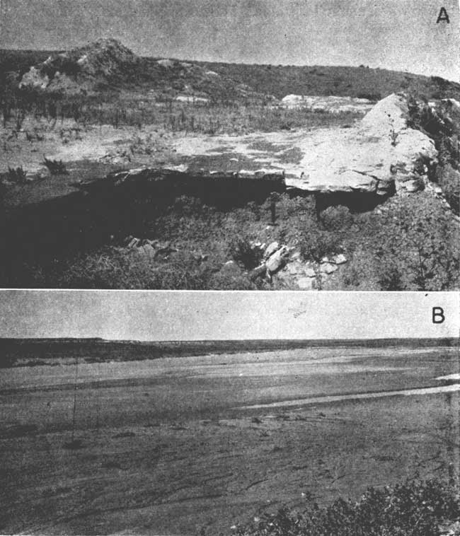
Plate 5--A, Abandoned quarry in Pearlette ash bed of Meade Group in sec. 11, T. 13 S., R. 35 W. Underlying the ash, which here reaches a thickness of 8 feet, is dark-gray shale. B, Sand and gravel in channel of Smoky Hill River in sec. 28, T. 14 S., R. 32 W. Light-colored cliffs in background are chalk of Niobrara formation, capped by darker Crete formation of Sanborn Group.
The drainage basin of Twin Butte Creek is elongated and bordered by high divides, and has moderate to steep slopes and no large tributaries. The slope to the floodplain from the apex of the divide on the north side is considerably gentler than that on the south side, where prominent bluffs are common. The stream has a gradient of about 20 feet per mile, dropping from 3,300 feet above sea level at the west border of the area to about 2,700 at its mouth. Average discharge is probably less than 3 cfs, as during the hot, dry part of the summer the stream is dry except for pools of water in low spots in the channel.
Chalk Creek occupies a long narrow drainage basin having a gentle northern slope and a steeper southern slope. The valley is not deep and, except for a small stretch in the western part of the county, is cut into the Niobrara formation. The stream has a gradient of about 24 feet per mile, dropping from an altitude of about 3,400 feet at the west edge of the county to about 2,700 at its mouth. Average discharge is probably less than 6 cfs. The valley is incised below the contact of the Ogallala and Niobrara formations over most of its length, and springs are common in the stretch between sec. 36, T. 15 S., R. 35 W., and sec. 31, T. 15 S., R. 36 W. Running water in the channel farther downstream is infrequent during the hot dry summers, despite the increments in flow from the springs.
Ladder Creek drains an area of approximately 1,460 square miles lying mostly south and west of Logan County. The valley is incised into the Ogallala formation in Scott, Wichita, and Greeley counties. In those areas, the Ogallala provides a perennial discharge, but the water is consumed completely by evapotranspiration in the summer months, hence the stream is often dry through its extent in Logan County. Maximum discharge, not affected by discharge from the dam at Lake McBride, was 8,650 cfs on June 11, 1951.
Lakes
Intermittent lakes are prevalent throughout Logan County, but only a few are more than a few hundred acres in area. The lakes can be divided into four distinct types: (1) lakes in deep depressions; (2) small, shallow upland ponds; (3) small ponds along watercourses; and (4) artificial stock ponds.
The large, deep depressions are a unique feature of the upland topography. Area of the depressions ranges from a few hundred acres to somewhat more than 3,000 acres. They are in sec. 2, T. 12 S., R. 37 W.; sec. 6, T. 12 S., R. 36 W.; sec. 6, T. 11 S., R. 36 W.; sec. 12, T. 13 S., R. 33 W.; and sec. 13, T. 13 S., R. 33 W. A very well developed depression and a good example of the type is in sec. 29, T. 12 S., R. 33 W. (Pl. 6A). The largest of the depressions is in the south-central part of T. 12 S., R. 37 W. The depression floor is sometimes flooded over an area of several hundred acres after heavy rains, but is commonly dry during hot, dry periods when runoff from precipitation to the lake is small.
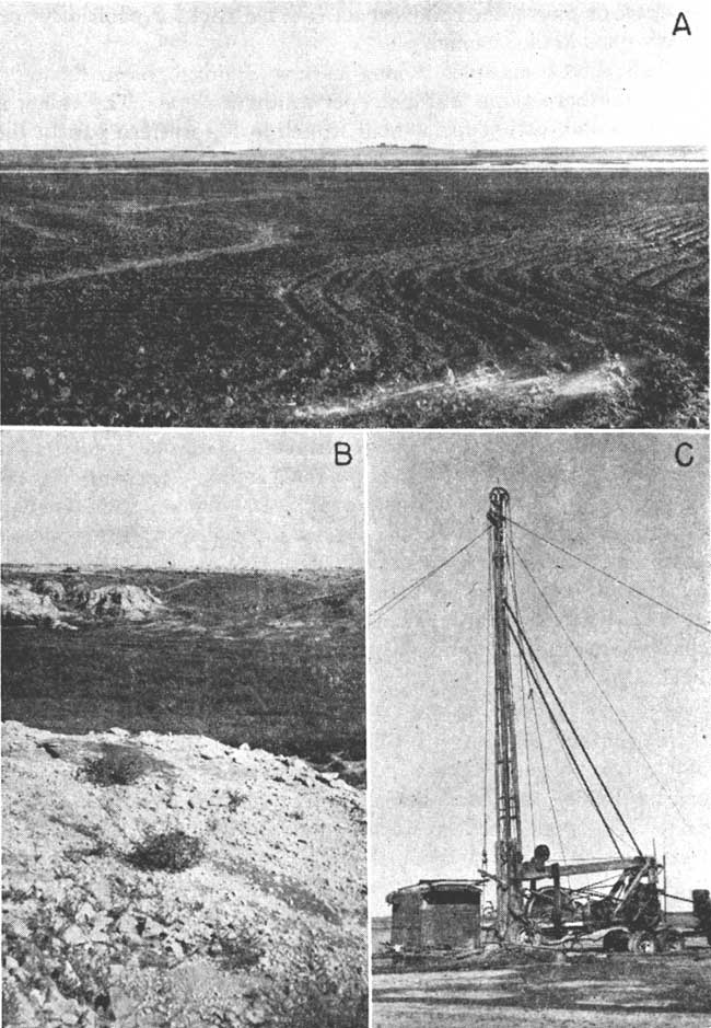
Plate 6--A, Large, deep depression in sec. 29, T. 12 S., R. 33 W. The bottom of the depression probably is lower than the base of the sandstone of the Ogallala formation in the surrounding slopes. B, Fault bringing Pierre shale against Niobrara formation in sec. 17, T. 13 S., R. 35 W. Niobrara formation is exposed in foreground and left background; Pierre shale is exposed in right background. Fault strikes nearly due east parallel to jointing along which hammer is laid; fault plane dips to right. C, Chum drill owned by John Heim, Dorrance, at site of first successful well in Dakota formation in Logan County. Well was drilled on S. Dirks farm to depth of 1,230 feet. Water rose under artesian pressure to within 695 feet of surface.
The deep upland depressions probably resulted from subsidence of the underlying Cretaceous rocks. A local subsidence in Wallace County in 1926 and recent subsidences in Sherman and Hamilton counties support this view. The basins seem too deep in relation to their area to be a result of wind erosion. The differential compaction of Tertiary sediments has been suggested as a causal factor (Johnson, 1901), but cannot be a cause of those depressions directly underlain by Cretaceous rocks or by very thin Tertiary rocks.
Elias (1931, p. 232-233) believed that the subsidences were caused by solution of chalk in the Niobrara formation along existing fault planes and the sudden collapse of the ensuing cavities. Moore (1926) explained the subsidences as resulting from solution of the shaly chalk of the Niobrara formation along its bedding planes. The thickness of Pierre shale beneath many of the depressions is several hundred feet and presumably would increase as one result of slumping. The size of cavern required to accommodate sufficient material to produce an appreciable basin would suggest solution on a scale great enough to be noticeable in exposures of the Niobrara formation. Evidence of large caverns in the extremely shaly Niobrara formation or of extensive solution along the faults where exposed in Logan County is lacking, however.
Russell (1929a) explained the recent subsidences as resulting from collapse of cavities formed by late Pliocene to early Pleistocene faulting. Tensional faulting, which has produced small local grabens in Logan County, may be continuing to the present time. Definite proof of the origin of these unusual topographic features is lacking, but this explanation seems to be the most plausible.
Hundreds of the small undrained shallow basins that are characteristic of the uplands of the High Plains are present in Logan County. The "lagoons" or "buffalo wallows," as they are locally called, are a few acres to several tens of acres in area. After heavy rains, storm runoff collects in these small basins, forming temporary lakes. The water in the ponds is shallow and generally evaporates or seeps into the ground after a few weeks. The larger depressions were mapped from aerial photographs and are shown on Plate 1.
Darton (1905, p. 36-37) explained the origin of these High Plains depressions as resulting from the action of buffalos and wind. Johnson (1901, p. 702-704) attributed them to rainwater accumulation in initial faint unevenness of the plain. The seeping of the water beneath the pond caused a settling of the underlying sediments by mechanical compaction and solution.
In Logan County, the lagoons are wet only for short periods after rains. When dry, the floors of the lagoons are the source of much blowing dust, which buries fences and fills roadside ditches in the vicinity of the ponds. Consequently, eolian erosion of the floor of the basin not protected by vegetation or plowing is not a negligible factor.
Frye (1945, p. 29) observed that some of the depressions are aligned along shallow valleys. These alignments are well developed in Logan County, particularly southeast of Winona and in the northeastern part of T. 12 S., R. 34 W. In stream channels, basins resulting from irregularities in deposition along the length of a stream are well known. In the uppermost reaches of a stream, where the valley is shallow and broad and begins to fade into the upland plain, these same irregularities probably exist. Such local reversals of gradient would cause shallow, broad undrained areas in which some of the stream runoff would accumulate. The turf would be destroyed, and upon drying, the floor of the basin would be subjected to eolian erosion, with perhaps some help from animals, both deepening and somewhat increasing the area of the basin. The basin would thus be able to accumulate more water, the endless circle would continue, and the basin would persist. As depth increased, wind velocity across the bottom would be reduced and periods of inundation would be longer, and both these factors would decrease deflation. None of the shallow depressions exceeds 50 acres in area.
The extremely large depressions in sec. 12, T. 13 S., R. 34 W., and sec. 11 and 12, T. 12 S., R. 37 W., are related to depressions in the Pierre shale, which underlies both.
The small ponds along watercourses are developed in the same way as the original ponds from which the upland shallow depressions evolved. The small depressions are in fairly deep valleys and narrow draws that protect them from the wind, and thus they escape enlargement and deepening by eolian action. The bottoms of the draws in many places support a dense vegetation and stay wet for long periods, and any wind action that otherwise would be effective is minimized. As a result, these depressions are less than an acre in area, arranged in alignment with the channel of the ephemeral or intermittent stream that connects them in many places, steep sided and abrupt owing to abundant vegetation supporting the sides, and generally wet during a greater part of the year than other types of depressions in the area.
Population
According to the U. S. Census, Logan County in 1950 had a population of 4,206 and an average density of 3.9 inhabitants to the square mile, compared to an average of 24.4 for the state. [Note, Logan County population was 3,046 in 2000 U.S. Census, with a population per square mile of 2.8 (KU Institute for Policy & Social Research).] The population had increased from 3,688 in 1940. In 1950 the population of Oakley was 1,915 [2,173 in 2000]; Winona, 382 [228 in 2000]; Russell Springs, 161 [32 in 2000]; Monument, 141; Page City, 100; McAllaster, 25; and Elkader, 7.
Transportation
Logan County is served by the Union Pacific Railroad, a line of which crosses from east to west through Oakley, Monument, Page City, Winona, and McAllaster. The principal hard-surfaced highways are U. S. Highway 40, which parallels the railroad, and U. S. Highway 83, which crosses the eastern part of the county from north to south through Elkader and Oakley. Kansas Highway 25 extends from U. S. Highway 40 south through Russell Springs then west and south across the county. From a point about 3 miles west of Russell Springs to its junction with U. S. Highway 40, Highway 25 is hard surfaced; the rest is graveled. There are several gravel-surfaced county highways and an extensive system of improved section-line roads. Oakley has a small airport.
Agriculture
Agriculture is the dominant economic activity in Logan County, the prinicipal types being wheat farming, cattle raising, and general farming. The principal crops are wheat and grain sorghums, but smaller acreages commonly are planted to barley, alfalfa, oats, and corn. In 1950 the value of crops sold was 60 percent of the total value of all agricultural products sold to market from Logan County; 37 percent was from the sale of livestock; and less than 2 percent was from dairying.
According to the U. S. Census of 1950, the number of farms in Logan County was 437, the average acreage 1,234, and the average value of both land and buildings $42,278. In 1954, 11 wells were used to irrigate nearly 1,000 acres. Principal crops irrigated were grain sorghum, corn, and alfalfa.
Mineral Resources
Logan County has no known mineral resources of great value other than soil and ground water. Sand and gravel deposits in the alluvium and other Pleistocene units along Smoky Hill River are worked to some extent for road-surfacing material. Chalk from the Smoky Hill chalk member of the Niobrara formation is quarried for use as building stone. The locations of pits and quarries are shown on Plate 1.
The Kansas Geological Survey (1931) described the diatomaceous marl beds in Wallace and Logan Counties and stated that preliminary study showed that the material could be burned for hydraulic lime and used in making slow-setting cement. Samples of rock collected in 1937 from exposures of the Ogallala formation in an escarpment in Scott County State Park just south of the southern border of Logan County contained sufficient calcium carbonate to be classified as wool rock (Plummer, 1937, p. 25-26). Presumably, rock of this quality is present in exposures of the Ogallala formation in Logan County. Five samples of the Bignell formation, Brady soil, and Peoria formation of the Sanborn group collected from the NE sec. 32, T. 12 S., R. 37 W. (Frye, Plummer, Runnels, and Hladik, 1949, p. 83), were found to be suited especially to the production of ceramic slag, which can be used for railroad ballast, riprap, road-surfacing material, and concrete aggregate. Plummer and Hladik (1951, p. 70-71) reported the suitability of a sample of Pierre shale collected in the center of the S2 sec. 8, T. 12 S., R. 36 W., for use in the manufacture of light-weight concrete aggregate. Carey, Frye, Plummer, and Swineford (1952) described six exposures of volcanic ash in Logan County, some of which were mined by the State Highway Department for aggregate.
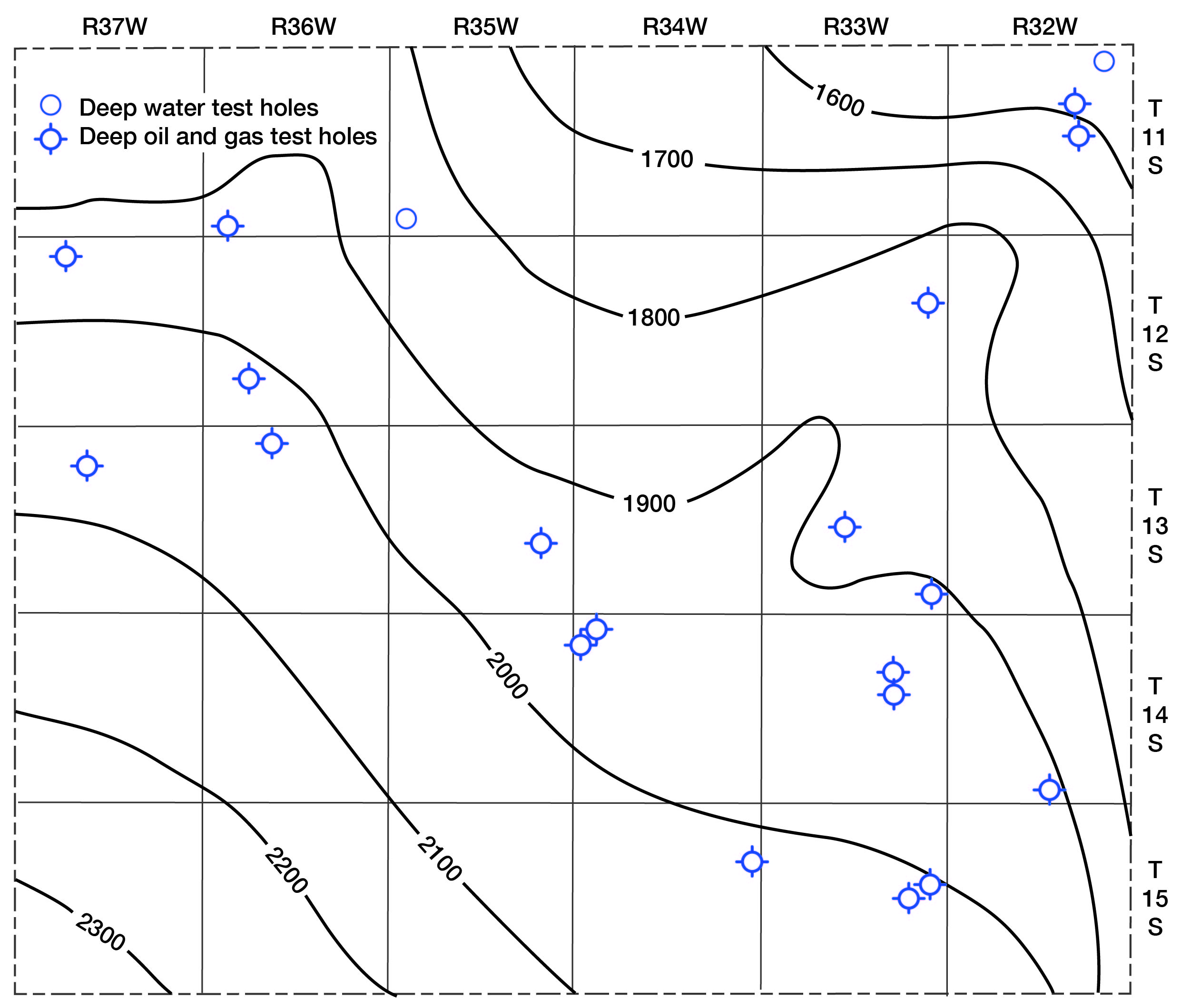
Prior to 1955, nineteen wildcat wells had been drilled in Logan County (Fig. 3) in attempts to discover oil or gas, but all were unsuccessful. Subsequently four additional dry holes were drilled in 1956. The county has been geophysically surveyed, and the recent successful oil wells in Gove and Scott counties probably will stimulate further prospecting for oil in Logan County. [Current information on the oil production of Logan County can be found online.]
Fig. 3--Regional structure of Logan County shown by contouring top of Dakota formation.
Climate
The climate of Logan County is semiarid and is characterized by abundant sunshine, moderate precipitation, considerable wind, a high rate of evaporation, and relatively low humidity. The effects of the summer heat are reduced to some extent by low humidity and brisk winds; the summer days are hot, but the nights are generally cool. The winters are moderate and have little snowfall and only short periods of severely cold weather.
In Logan County the amount of precipitation and its seasonal distribution are the chief factors governing crop growth. According to records of the U. S. Weather Bureau, about 77 percent of the annual precipitation falls during the 6-month growing season from April through September.
The U. S. Weather Bureau maintains precipitation gages at Oakley, Russell Springs, and Winona, and near Elkader. The normal annual precipitation at Oakley (Fig. 4), which has the longest record, is 18.97 inches. The recorded precipitation in Logan County has ranged from a minimum of 8.84 inches at Russell Springs in 1916 to a maximum of 34.63 inches at Oakley in 1941.
Fig. 4--Graphs showing normal annual precipitation and progressive 10-year average precipitation at Oakley.
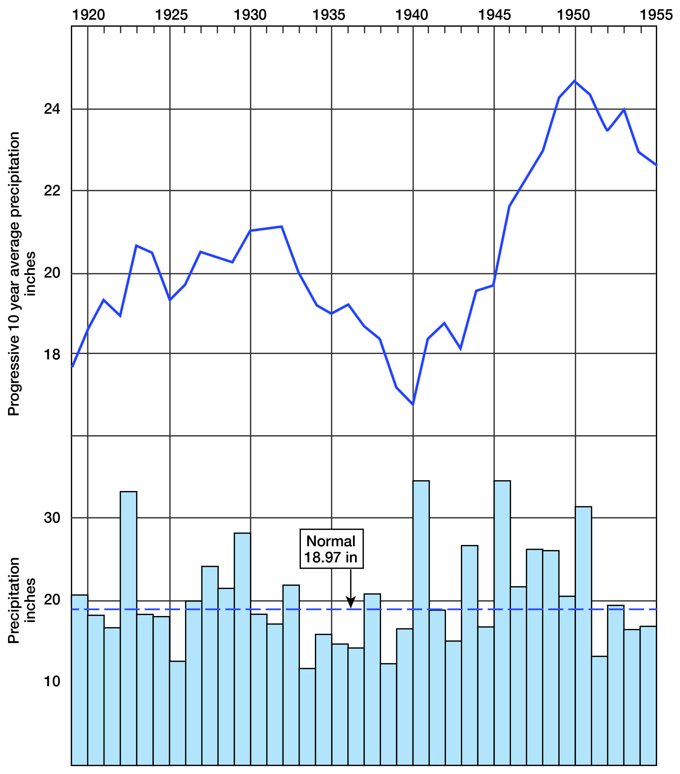
Foley, Smrha, and Metzler (1955) suggested that there may be cyclic trends in Kansas precipitation; the statewide precipitation trended upward in the periods 1902-09, 1920-31, and 1941-51, and downward in 1910-19, 1932-40, and again beginning in 1952. These trends are demonstrated by a curve of the progressive 10-year average precipitation at Oakley (Fig. 4), which smoothes out the large variations of annual precipitation. Each point on the graph represents the average annual precipitation of the previous 10 years.
The annual mean temperature at Oakley is 53.3 °F. The lowest recorded temperature at Oakley was -24 °F on February 8, 1933, and the highest was 111 °F on June 24,1936.
Evaporation is not recorded in Logan County by an official agency, but evaporation data available from U. S. Weather Bureau stations at Tribune and Colby suggest that the potential annual evaporation in Logan County is probably about 60 inches.
The average date of the last killing frost in the spring is May 2 and the average date of the first killing frost in the fall is October 12. The average length of the growing season is 163 days.
Prev Page--Introduction || Next Page--Geology
Kansas Geological Survey, Geology
Placed on web Dec. 10, 2007; originally published May, 1958.
Comments to webadmin@kgs.ku.edu
The URL for this page is http://www.kgs.ku.edu/General/Geology/Logan/03_geog.html