![]()
Prev Page--Geology || Next Page--Recharge
Ground Water
Principles of Occurrence
The following discussion of the occurrence of ground water has been adapted from Meinzer (1923, pp. 2-102) and the reader is referred to his report for a more detailed discussion. A general discussion of the principles of ground-water occurrence with special reference to Kansas has been made by Moore and others (1940).
All the water below the surface of the earth is termed subsurface water. The part of subsurface water that is in the zone of saturation is called ground water or phreatic water whereas subsurface water above the zone of saturation is called suspended subsurface water or vadose water. Ground water is the water that is obtained from wells and springs.
The rocks that form the outer crust of the earth are seldom solid throughout. They contain numerous open spaces called voids or interstices which may contain air, gas, oil, or water. The occurrence of water in the rocks of any region is determined by the character, distribution, and structure of the rocks--that is, by the geology of the region.
Interstices in rocks range in size from microscopic openings to large caverns. The open spaces are generally connected so that water may percolate from one to another, but in some rocks the interstices are largely isolated and the water has little opportunity to percolate.
In Lane County most of the ground water is obtained from poorly consolidated sands and gravels of the Ogallala formation. Generally Tertiary sands and gravels contain many interstices through which water may percolate, but locally the interstices are filled with calcium carbonate, silt, or clay, which makes the rock relatively impermeable. In many places the sands of the Ogallala are very poorly sorted and silt and fine sand fill the interstices, thereby decreasing the amount of space available for ground water. The lenticular sandstones in the Dakota formation yield water to a few wells in Lane County. These sandstones still have enough voids to contain water, although the individual sand grains are generally cemented with iron oxide, silicon dioxide, or calcium carbonate.
The porosity of a rock is its property of containing interstices. The porosity is expressed quantitatively as the percentage of the total volume of the rock that is occupied by interstices. When all the interstices are full of water, a rock is said to be saturated and the porosity is practically the percentage of the total volume of rock that is occupied by water.
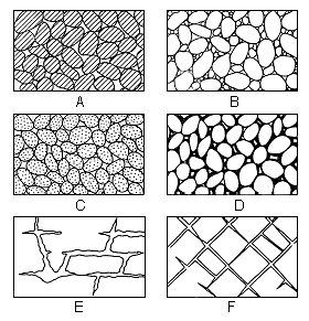
A rock may be very porous but may yield very little water to wells. A rock containing small interstices may be very porous, but water might pass through it with difficulty whereas a coarse-grained rock, although possibly less porous, might allow water to pass through it more freely. Several common types of open spaces or interstices and the relation of texture to porosity are shown in Figure 7. The specific yield of a water-bearing formation is defined as the ratio of (1) the volume of water which, after being saturated, the formation will yield by gravity to (2) its own volume. Specific yield is a measure of the yield of a water-bearing formation when it is drained by a lowering of the water table. The permeability of water-bearing material is defined as the material's capacity for transmitting water under hydraulic head; it is measured by the rate at which the material will transmit water through a given cross section under a given difference of head per unit of distance.
Fig. 7--Diagram showing several types of rock interstices and the relation of rock texture to porosity. A, well-sorted sedimentary deposit having a high porosity; B, poorly sorted sedimentary deposit having low porosity; C, well-sorted sedimentary deposit consisting of pebbles that are themselves porous so that the deposit as a whole has a very high porosity; D, well-sorted sedimentary deposit whose porosity has been diminished by the deposition of mineral matter in the interstices; E, rock rendered porous by solution; F, rock rendered porous by fracturing. (From O. E. Meinzer.)
The upper surface of the zone of saturation is called the ground-water table or the water table. All the rocks above the water table are in the zone of aeration, which usually consists of three parts: the belt of soil water, the intermediate or vadose zone, and the capillary fringe.
The belt of soil water lies just below the land surface and contains water held by molecular attraction. The thickness of the zone is dependent upon the character and thickness of the soil and upon the precipitation and vegetation.
The intermediate zone lies between the belt of soil water and the capillary fringe. The interstices in this zone usually are filled with air but may at times contain appreciable amounts of water while it is moving downward to the water table. The intermediate zone may be absent in places where the water table is near the surface, or it may be more than 100 feet thick as in parts of Lane County.
The capillary fringe, which lies directly above the water table, comprises water rising from the zone of saturation by capillary action. The water in the capillary fringe is not available to wells, which must be deepened to the saturated zone before water will enter them. The capillary fringe is very thin in coarse-grained sediments where capillary action is negligible, but may be several feet thick in fine-grained sediments.
Rock Types and Their Water-bearing Properties
Water in Sand and Gravel
Lane County is underlain by deposits of unconsolidated and partially cemented materials that were laid down by streams in Tertiary and Quaternary time. The sorting action of streams on these sediments resulted in the deposition of distinct beds of gravel, sand, silt, and clay. Deposits of such uniform texture may have a relatively high porosity. Coarse, well-sorted gravel of this type has a high specific yield and permeability, whereas uniform deposits of silt or fine sand, although very porous, have a low specific yield and low permeability. Properly constructed wells in well-sorted uniform gravel yield large quantities of water. Much of the stream-laid material is poorly sorted, and fine material occupies much of the pore space between the larger grains, thus reducing the porosity and the specific yield.
The largest ground-water supplies in Lane County are obtained from beds of sand and gravel in the Ogallala formation. All the active irrigation wells and the majority of domestic and stock wells obtain their water from the Ogallala. In the southwest corner of the county, Pleistocene silts and fine sands of the Meade (?) formation yield water to wells, and Recent alluvial deposits yield small supplies of water along stream valleys.
Water in Sandstone
Sandstone ranks next to sand in its ability to store and transmit water. The factors determining the water-bearing properties of a sandstone are the grain size, sorting, and cementation. A coarse-grained, well-sorted sandstone generally yields water freely, whereas a well-sorted fine-grained sandstone may contain much water, but will surrender it slowly. Many sandstones are so tightly cemented that they will not yield water from the original openings between grains. A tightly cemented sandstone may, however, contain joints and fractures that bear water.
The Dakota formation contains the only water-bearing sandstones known to yield water to wells in Lane County. Information on the yield of these wells and on the character of the water-bearing beds is not available.
Water in Limestone and Shale
Chalk, chalky limestone, and chalky shale are usually not important sources of water, but several wells in southern Lane County derive part of or all their water from the chalky limestone of the Fort Hays member of the Niobrara formation. Water occurs in limestone in fractures or in solution openings caused by water containing dissolved carbon dioxide. The occurrence of fractures and solution openings is very irregular, making it difficult to predict where water may be found in a limestone. Sometimes many test wells must be drilled to locate openings before a final well can be put down. In some areas it is impossible to recover enough water from limestone and chalk to supply even small domestic or stock wells.
Shale is a very unfavorable rock from which to obtain water. If not too tightly indurated, it may be highly porous and contain much water. However, the interstices are small and water held there by molecular attraction is not available to wells. Some water is found in shale along joints and bedding planes.
Permeability of the Water-bearing Materials
The rate of movement of ground water is determined by the size, shape, quantity, and degree of connection of the interstices and by the hydraulic gradient. The capacity of a water-bearing material for transmitting water under hydraulic head is its permeability. The coefficient of permeability in Meinzer's units may be expressed as the rate of flow of water, in gallons a day, through a cross-sectional area of 1 square foot under a hydraulic gradient of 100 percent at a temperature of 60° F (Stearns, 1927, p. 148). The coefficient of transmissibility is a similar measure and is defined as the number of gallons of water a day transmitted through each 1 foot strip extending the height of the aquifer under a unit gradient (Theis, 1935, p. 520). It may also be expressed as the number of gallons of water a day transmitted through each section 1 mile wide extending the height of the aquifer, under a hydraulic gradient of 1 foot to the mile. The coefficient of transmissibility is equivalent to the coefficient of permeability multiplied by the thickness of the aquifer.
Concerning the relation of permeability of water-bearing materials, Wenzel (1942, p. 11) states:
Although there are many water-bearing materials of low permeability, most formations that are sufficiently water-bearing to be utilized by wells have coefficients that are whole numbers of two or more figures when expressed in Meinzer's units--that is, above 10. The yields of wells depend, of course, not only on the permeability of the formations they tap but also on the thickness of the formations, the drawdown of the water level, and the diameter and construction of the wells. For many places in the United States the physical and economic conditions are such that wells with moderate to high yields--100 gallons a minute or more--generally penetrate materials with coefficients of permeability of 100 or more.
Pumping Tests
The coefficient of permeability of water-bearing materials can be determined in the laboratory (methods summarized by V. C. Fishel in Wenzel, 1942, pp. 56-58) or in the field using the recovery method involving the formula developed by Theis (1935, p. 522) and later described by Wenzel (1942, pp. 94-96). Three pumping tests were made in Lane County in September 1948 by Woodrow W. Wilson of the Federal Geological Survey.
From his final equation expressing the relation between the drawdown and the rate and duration of the discharge of a well, Theis developed the following formula:
T = [(264 q) / s] log10 (t/t1)
in which T = coefficient of transmissibility
q = pumping rate, in gallons a minute
t = time since pumping started, in minutes
t1 = time since pumping stopped, in minutes
s = residual drawdown at the pumped well, in feet, at time t1
The residual drawdown (s) is computed by subtracting the static water-level measurement from depth to water-level measurements made after pumping ceases.
The proper ratio of log10 (t/t1) to s is determined graphically by plotting log10 (t/t1) against corresponding values of s. This procedure is simplified by plotting (t/t1) on the logarithmic coordinate and s on the arithmetic coordinate of semi-logarithmic paper. If log10 (t/t1) is taken over one log cycle it will become unity and s will be the difference in drawdown over one log cycle.
Theoretically the curve is a straight line that passes through the origin. It does not do so for all pumping tests, however. W. F. Guyton, in a personal communication, stated that this condition need not be fulfilled; therefore, in these pumping tests no empirical correction was made in order that the straight line pass through the origin. Adjustment for temperature was unnecessary as the temperature was only slightly less than 60° F.
Well 17-28-22aaa, an irrigation well on the farm of Carl Filbert, was pumped for approximately 4 hours on Sept. 29, 1948. Drawdown measurements were made with a wetted tape during the period of pumping, and recovery measurements were made for nearly 2 hours after the pump was shut down. The well was pumped at an average rate of 1,040 gallons a minute (determined by a Collins flow meter); at the end of pumping the drawdown was 23.23 feet and the specific capacity was about 45 gallons per minute per foot of drawdown.
The computations for permeability and transmissibility are as follows:
T = (264 X 1,040 X 1) / 1.18 = 233,000 gpd/ft
P = 233,000 / 69 = 3,400 gpd/sq ft
The transmissibility is computed to be 233,000 gallons per day per foot and the coefficient of permeability, determined by dividing the transmissibility by the thickness of the aquifer, which is 69 feet, is 3,400 gallons per day per square foot. These values are higher than values obtained in other pumping tests made in Lane County. Curves for the pumping test on well 17-28-22aaa are shown in Figure 8; data that were plotted to obtain these curves are given in Table 3. Results of this test and two other pumping tests are summarized in Table 4.
Fig. 8--Curves for pumping test on well 17-28-22aaa on the Carl Filbert farm.
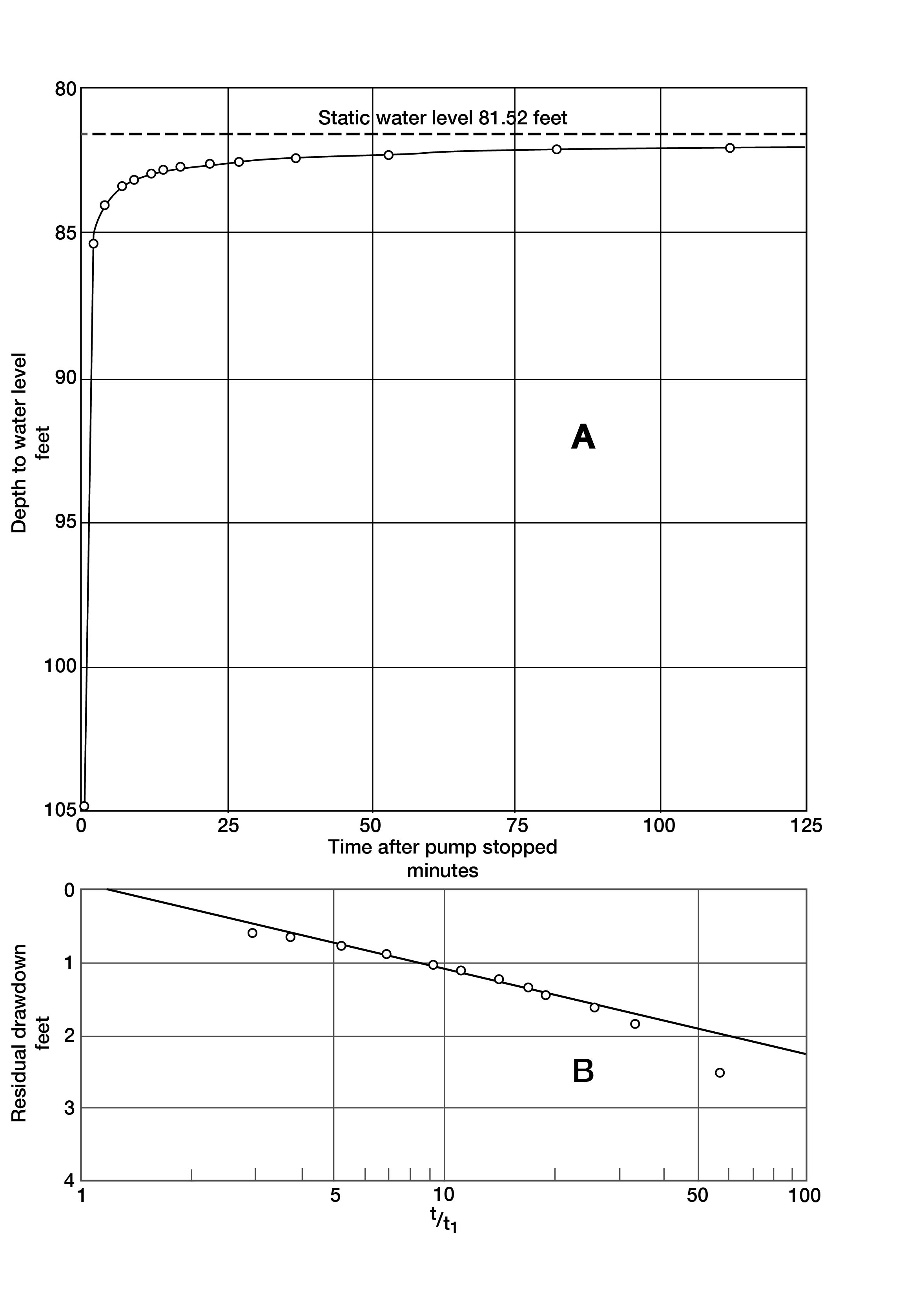
Table 3--Data on pumping test of well 17-28-22aaa in Lane County, Kansas, made on Sept. 29, 1948.
| Time since pumping started, minutes |
Time since pumping stopped, minutes |
t/t1 | Yield, gallons per minute |
Depth to water, feet |
Drawdown, feet |
|---|---|---|---|---|---|
| 81.52 | |||||
| 9 | 1051 | 104.80 | 23.28 | ||
| 39 | 1037 | 104.75 | 23.23 | ||
| 69 | 1037 | 104.95 | 23.43 | ||
| 99 | 1034 | 105.10 | 23.58 | ||
| 129 | 1047 | 104.70 | 23.18 | ||
| 159 | 1039 | 104.80 | 23.28 | ||
| 189 | 1034 | 104.75 | 23.23 | ||
| 219 | 1041 | 104.75 | 23.23 | ||
| 229 | 2 | 114.5 | 85.35 | 3.83 | |
| 231 | 4 | 57.8 | 84.04 | 2.52 | |
| 234 | 7 | 33.4 | 83.38 | 1.86 | |
| 236 | 9 | 26.0 | 83.14 | 1.62 | |
| 239 | 12 | 19.9 | 82.95 | 1.43 | |
| 241 | 14 | 17.2 | 82.85 | 1.33 | |
| 244 | 17 | 14.4 | 82.74 | 1.22 | |
| 249 | 22 | 11.3 | 82.62 | 1.10 | |
| 254 | 27 | 9.4 | 82.54 | 1.02 | |
| 264 | 37 | 7.1 | 82.42 | .90 | |
| 280 | 53 | 5.3 | 82.30 | .78 | |
| 309 | 82 | 3.8 | 82.19 | .67 | |
| 339 | 112 | 3.0 | 82.13 | .61 |
Table 4--Results of pumping tests made on wells in Lane County, Kansas, using the Theis recovery method for determining permeability.
| Well number | Discharge, gallons a minute |
Drawdown, feet |
Duration of pumping, minutes |
Specific capacity |
Coefficient of transmissibility |
Approximate thickness of water-bearing material, feet |
Coefficient of permeability |
|---|---|---|---|---|---|---|---|
| 16-29-28dab | 550 | 36.37 | 252 | 15.1 | 23,000 | 73 | 320 |
| 17-28-22aaa | 1,040 | 23.23 | 227 | 44.8 | 233,000 | 69 | 3,400 |
| 17-28-15cb | 790 | 11.52 | 242 | 68.6 | 174,000 | 60 | 2,900 |
Artesian Conditions
Artesian water is ground water under sufficient pressure to rise above the point at which it is encountered in wells. A well that flows at the land surface is a flowing artesian well. To be under artesian conditions a water-bearing bed must be overlain by an impermeable or relatively impermeable bed that dips from its outcrop area to its area of discharge. Water entering the bed at the outcrop percolates down gradient where it is held in the water-bearing bed by the overlying confining layer. Down dip from the outcrop the water exerts considerable pressure against the confining bed, causing the water to rise in a well drilled through the confining layer. If the water is under sufficient pressure and if the land surface of the well is at a lower altitude than that at the outcrop area, the water may rise high enough to flow at the surface. In places where there are lenses or beds of relatively impermeable clay or silt at the level of the water table, the water encountered beneath such lenses will rise to the level of the surrounding water table, but such water is under normal pressure and is not considered artesian.
Lane County has no flowing artesian wells, but it is reported that a seismograph drilling crew found an artesian flow in a shot hole drilled in the northeast corner of sec. 22, T. 18 S., R. 27 W. The depth of this hole is not known but the aquifer was probably a lenticular sandstone in the Dakota formation.
Artesian water has been found in several wells drilled to the Dakota formation in Lane County. Logs of these wells are not available, but Mr. Carlos Roberts informed me that in a 673-foot well drilled on his farm in the SE SW NW sec. 4, T. 16 S., R. 28 W., an artesian aquifer was encountered at 642 feet and that the water rose to 285 feet. In 1948 at the time of this investigation the water level was 296 feet below the land surface.
The Water Table and Movement of Ground Water
Shape and Slope
The water table is defined as the upper surface of the zone of saturation except where that surface is formed by an impermeable body (Meinzer, 1923a, p. 32). Where the upper surface is formed by impermeable material (as in several areas in Lane County) the water table is absent. The water table is not a plane surface in all parts of the county. Its shape is roughly comparable to that of the land surface although it is not so rugged. It fluctuates owing to variations in discharge and recharge.
The shape and slope of the water table are shown on Plate 1 by contour lines drawn on the water table. Water-table contour lines connecting points of equal altitude show the configuration of the water surface just as topographic contour lines show the shape of the land surface. The direction of movement of ground water is at right angles to the water-table contour lines.
It is not practical to draw water-table contours for several areas in Lane County because there is little or no water-bearing material in some areas (Fig. 9). Occasionally a well drilled in these areas obtains a little water from the Ogallala but generally a dry hole is the result. Some wells in areas where the Cretaceous bedrock is at or near the surface obtain water from limestone, shale, or alluvium in stream valleys. In some areas water cannot be obtained from limestone and chalk, and deep wells may be drilled to sandstone lenses in the Dakota.
Plate 1 shows that the ground water is moving through Lane County in a general easterly direction. Local differences in permeability and thickness of the water-bearing beds affect the slope of the water table, the average being about 10 feet to the mile. In general, the slope of the water table varies inversely with the permeability of the water-bearing material. In areas where the water-bearing beds are relatively impermeable, the slope of the water table steepens, but in areas of permeable water-bearing beds, the water-table contours are farther apart.
Fluctuations in Water Level
The water table is not a static surface but a surface that fluctuates much like the surface of a lake. Over a long period of time, a condition of approximate equilibrium exists between the amount of water that is added annually to ground-water storage and the amount that is discharged annually by both artificial and natural means. In general, the water table rises when the amount of recharge exceeds the amount of discharge and declines when the discharge is greater than the recharge. Thus, changes in water levels in wells record the fluctuations of the water table and indicate to what extent the ground-water reservoir is being depleted or replenished.
The principal factors controlling the rise of the water table in Lane County are the amount of precipitation that penetrates the ground and reaches the zone of saturation, seepage from streams and depressions, and the amount that enters the county beneath the surface from the west. Factors controlling the decline of the water table are pumpage from wells, seeps and springs, evaporation and transpiration in shallow-water areas, and the eastward movement of ground water out of the county. The factors causing the water table to rise are discussed in the section on groundwater recharge and the factors causing the water table to decline are discussed in the section on ground-water discharge.
In the summer of 1948 a few wells in Lane County were selected as observation wells in order to obtain information concerning fluctuations in storage of the underground reservoir. No regular measurements of these wells were made until January 1950. Prior to this time, no record of water-table fluctuations had been kept in Lane County, although a close check on water levels has been kept for several years in adjacent Scott and Finney counties.
Prev Page--Geology || Next Page--Recharge
Kansas Geological Survey, Geology
Placed on web Jan. 18, 2008; originally published Sept., 1951.
Comments to webadmin@kgs.ku.edu
The URL for this page is http://www.kgs.ku.edu/General/Geology/Lane/05_gw.html