![]()
Prev Page--Geography || Next Page--Ground water occurrence
Geology
Summary of Stratigraphy
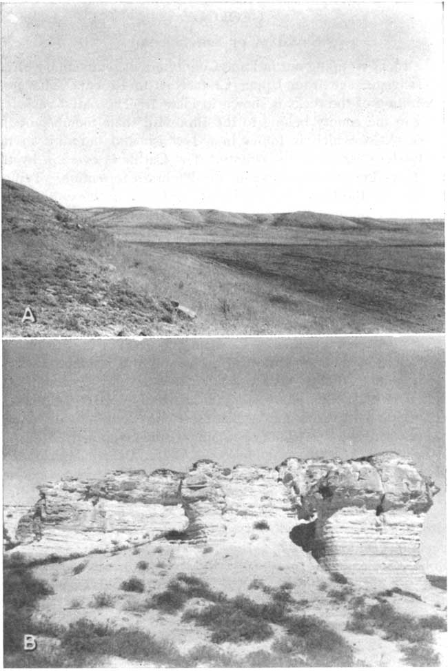
The rocks cropping out in Lane County are of sedimentary origin and range in age from Upper Cretaceous to Recent. The areal distribution of the rocks is shown in Plate 1. The oldest rocks exposed in the county belong to the Blue Hill shale member of the Carlile shale, which is found in a few isolated outcrops in the southeastern corner of the county. The Carlile is overlain by the Fort Hays limestone member of the Niobrara formation. Typical exposures of the Fort Hays limestone are found in the southeastern part of the county (Pl. 5A). The Smoky Hill chalk member of the Niobrara is next in ascending order and is found in excellent outcrops along tributaries to Smoky Hill River in the northern part of the county (Pl. 5B). It also crops out on the south side of the north and south forks of Walnut Creek as well as along several other intermittent drainage ways. The Pierre shale which overlies the Niobrara formation in other areas is absent in Lane County.
Plate 5--The Niobrara formation in Lane County. A, Bluffs formed by exposures of Fort Hays limestone member of the Niobrara formation; view looking southwest in sec. 25, T. 20 S., R. 27 W. B, Outcrop of Smoky Hill chalk member of the Niobrara formation showing massive beds at top and shaly beds below; sec. 8, T. 16 S., R. 30 W.; view looking north.
The Ogallala formation of Pliocene are overlies the Cretaceous beds in the uplands over most of the county. It is exposed on the sides of many of the stream valleys, and several small bills are capped by the "Algal limestone" (Elias, 1931, pp. 136-141) which is the uppermost bed in the Ogallala section. A basin-like depression in southwestern Lane County contains sediments thought to belong to the Meade formation of Pleistocene age. Over a large part of the county, the Ogallala is overlain by the Pleistocene Sanborn formation which consists predominantly of eolian silt. Locally a small amount of sand and gravel occurs at the base of the Sanborn formation (Fig. 6). Colluvial materials derived in part from Pliocene and Cretaceous rocks and in part from the upland loess of the Sanborn formation mantle many slopes. These colluvial slope deposits are included with the Sanborn formation on the geologic map (Pl. 1). A small area in the southwest corner of the county is covered by dune sand, which is thought to be late Pleistocene in age. The most recent deposits are narrow bands of alluvium that occupy parts of the valleys of the several small creeks that head in Lane County.
The character and ground-water supply of the geologic formations are briefly described in Table 2, and more detail is given in the section on geologic formations and their hydrologic properties.
Table 2--Generalized section of the geologic formations of Lane County, Kansas. The stratigraphic classification used in this report is that of the State Geological Survey of Kansas.
| System | Series | Formation | Member | Thickness, feet |
Character | Water supply |
|---|---|---|---|---|---|---|
| Quaternary | Pleistocene | Alluvium | 0-35 | Sand, gravel, and silt comprising narrow bands of stream deposits along the forks of Walnut Creek and along the tributaries to Smoky Hill and Pawnee Rivers. | Yields small supplies of moderately hard water to wells. | |
| Unconformable on older formations | ||||||
| Dune sand | 0-40± | Fine to medium-grained wind-blown sand. Covers a small area in southwestern corner of county | No wells known to derive water directly from the dunes. Dunes are important as catchment areas for recharge from local precipitation. | |||
| Unconformable on older formations | ||||||
| Sanborn formation (includes slope deposits) |
Peoria silt member and Loveland silt member |
0-25 | Tan to brownish massive silt. Locally contains some sand and gravel at the base. | The Sanborn formation usually occurs above the water table but yields small supplies of water to a few wells. | ||
| Unconformable on older formations | ||||||
| Meade (?) formation |
Sappa member, Grand Island member |
0-110 | Silt, clay, and very fine sand with a small amount of sand and gravel at the base. | Contains a large amount of water but because of fineness of material, yields are not large. Occurs in southwestern corner of county. | ||
| Unconformable on older formations | ||||||
| Tertiary | Pliocene | Ogallala formation |
0-160 | Gravel, sand, silt, clay, and caliche; predominantly calcareous. May be consolidated or unconsolidated. | The Ogallala is the principal water-bearing formation in Lane County. It yields moderate to large supplies of water to domestic and stock wells. The city of Dighton derives its water supply from the Ogallala as do several irrigation wells. | |
| Unconformity | ||||||
| Cretaceous | Gulfian | Niobrara formation |
Smoky Hill chalk member |
0-350± | Alternating beds of chalk and chalky shale. | Yields only small supplies of water to very few wells in areas where Tertiary deposits are thin. |
| Fort Hays limestone member |
0-50± | Massive chalk beds separated by chalky shale layers. | Not an important aquifer. Yields a small amount of water to some wells in southwestern Lane County. Water occurs in fractures. | |||
| Carlile shale |
Blue Hill shale member |
175-225 | Sandstone and sandy shale comprising the Codell sandstone zone in the upper part; bluish-gray noncalcareous shale, containing gypsum seams and septarian concretions. | Not known to yield water to wells in Lane County. | ||
| Fairport chalky shale member |
Calcareous shale with thin limestone beds. Not exposed in Lane County. | Not known to yield water to wells in Lane County. | ||||
| Greenhorn limestone |
100-105± | Alternating beds of thin chalky limestone and chalky shale. Not exposed in Lane County. | Yields no water to wells in Lane County. | |||
| Graneros shale |
50-55± | Gray noncalcareous shale containing lenses of sandstone. Not exposed in Lane County. | Not known to yield water to wells in Lane County. | |||
| Dakota formation |
250-300± | Sandstone, shale, and clay. | Yields moderate amounts of very soft water to several wells in areas where Tertiary deposits are thin or absent. | |||
Geologic History
Paleozoic Era
Cambrian and Ordovician Periods
Logs of test wells for gas and oil indicate that Lane County is underlain by at least 4,000 feet of sediments deposited during the Paleozoic era. During early Cambrian time Lane County, along with a large part of west-central United States, was a land surface. In middle Cambrian time an interior sea developed and persisted through most of the Ordovician Period. During the submergence there was extensive deposition of calcareous sediments, which are recognized in well cuttings and logs as the Arbuckle group of Cambrian and Ordovician age and the Viola limestone of Ordovician age. In a well in the NE sec. 25, T. 16 S., R. 29 W., the Arbuckle was encountered at 4,900 feet and penetrated to a total depth of 5,032 feet.
Silurian and Devonian Periods
Rocks of Silurian and Devonian ages are not known to underlie Lane County. A shallow sea or a low land mass may have been present but no evidence of either erosion or deposition is left.
Mississippian and Pennsylvanian Periods
During early Mississippian time there was extensive deposition of marine dolomitic limestone, along with some shale and cherty limestone. Well logs indicate that Mississippian strata are encountered at approximately 4,500 feet. Rock types found in formations of Mississippian age include oolitic limestone, dolomite, cherty limestone, and cherty dolomite. In later Mississippian time there was a period of uplift during which the early Mississippian strata were subjected to erosion. During Pennsylvanian time subsidence and uplift alternated several times, and both marine and continental sedimentary rocks, consisting of sandstone, limestone, coal, and shale, were formed. Pennsylvanian rocks are approximately 1,000 feet thick in Lane County. In a test well, the top of the Lansing and Kansas City groups was logged at 3,973 feet, the top of the Marmaton group at 4,428, and the top of the Mississippian at 4,574 (the James Farm No. 1 well in the NE NE sec. 25, T. 16 S., R. 29 W.)
Permian Period
During early Permian time alternating submergence and emergence of late Pennsylvanian rocks continued and limestone, dolomite, and shale were deposited. During the latter part of the period shallow basins and low plains were areas of continental deposition. Most of the deposition took place in shallow water, so that subsidence must have kept pace with deposition during this period. The climate must have been and and evaporation probably occurred in shallow basins, giving rise to extensive deposits of salt, anhydrite, and gypsum. Shale and sandstone were the predominant formations resulting from Permian continental deposition. According to Ver Wiebe (1939, p. 105) two anhydrite zones were found in one well--the Blaine at 1,620 feet and the Stone Corral at 2,170 feet. Both formations are in the Leonardian Series. Logs of deep tests show that Lane County is underlain by at least 2,000 feet of Permian sedimentary rocks.
Mesozoic Era
Triassic and Jurassic Periods
It is possible that some deposition occurred in the early part of Triassic time, but in the latter part of the Triassic Period this region was above sea level. Triassic deposits, if any, were removed by erosion and Permian rocks were also eroded. During Jurassic time, however, the area again was under water and deposition of sediments was resumed. The study of drill cuttings from an oil well test in the NW NE sec. 16, T. 16 S., R. 28 W. indicates that the Jurassic Morrison formation is represented by about 100 feet of gray to light-green shale in the subsurface of northern Lane County.
Cretaceous Period
During late Comanchean (early Cretaceous) time a shallow sea transgressed northward across central and western Kansas. The Cheyenne sandstone was deposited near the shore of this advancing sea and the Kiowa shale, which overlies it, in the deeper waters that subsequently covered the area. The sandstone, shale, and clay of the Dakota formation were deposited in a near-shore area at the beginning of Gulfian (late Cretaceous) time. The top of the Dakota is reported to have been encountered at depths ranging from 650 to 990 feet in Lane County. The combined thickness of the Cheyenne, Kiowa, and Dakota in Lane County is more than 500 feet.
After the deposition of the Dakota formation marine conditions prevailed throughout most of the remainder of Cretaceous time. Hundreds of feet of shale, limestone, and chalk were deposited. These formations in order of deposition are: Graneros shale, Greenhorn limestone, Carlile shale, and Niobrara formation. Thin beds of bentonite in these formations indicate that at different times volcanic ash was blown into the seas in which the sediments were being deposited. The ash settled in layers and was subsequently altered to bentonite.
The Pierre shale, which is the youngest Cretaceous formation in Kansas, is not found in Lane County. It was probably deposited during late Cretaceous time and subsequently was removed by erosion. In Gove County, immediately north of Lane County, the Pierre formation crops out in one small area.
Cenozoic Era
Tertiary Period
Prior to the deposition of Tertiary sediments in western Kansas there was a period of uplift and at the beginning of Tertiary time there was an extensive land surface. While streams were laying down widespread sheets of sand, gravel, and silt in the plains to the north, the land surface of western Kansas was being subjected to erosion and great thicknesses of Upper Cretaceous sediments were stripped off. In Lane County the Pierre shale, if ever deposited, was removed as were variable thicknesses of the Niobrara. According to Smith (1940, p. 80) the erosion surface on which the Ogallala formation was deposited was by no means a peneplain, but was characterized by considerable relief, locally as much as 200 feet (Figs. 5 and 6).
Fig. 5--Map of Lane County showing the configuration of the bedrock surface beneath the Ogallala by means of contours, the locations of test holes, and the altitudes at which bedrock was encountered in test holes.
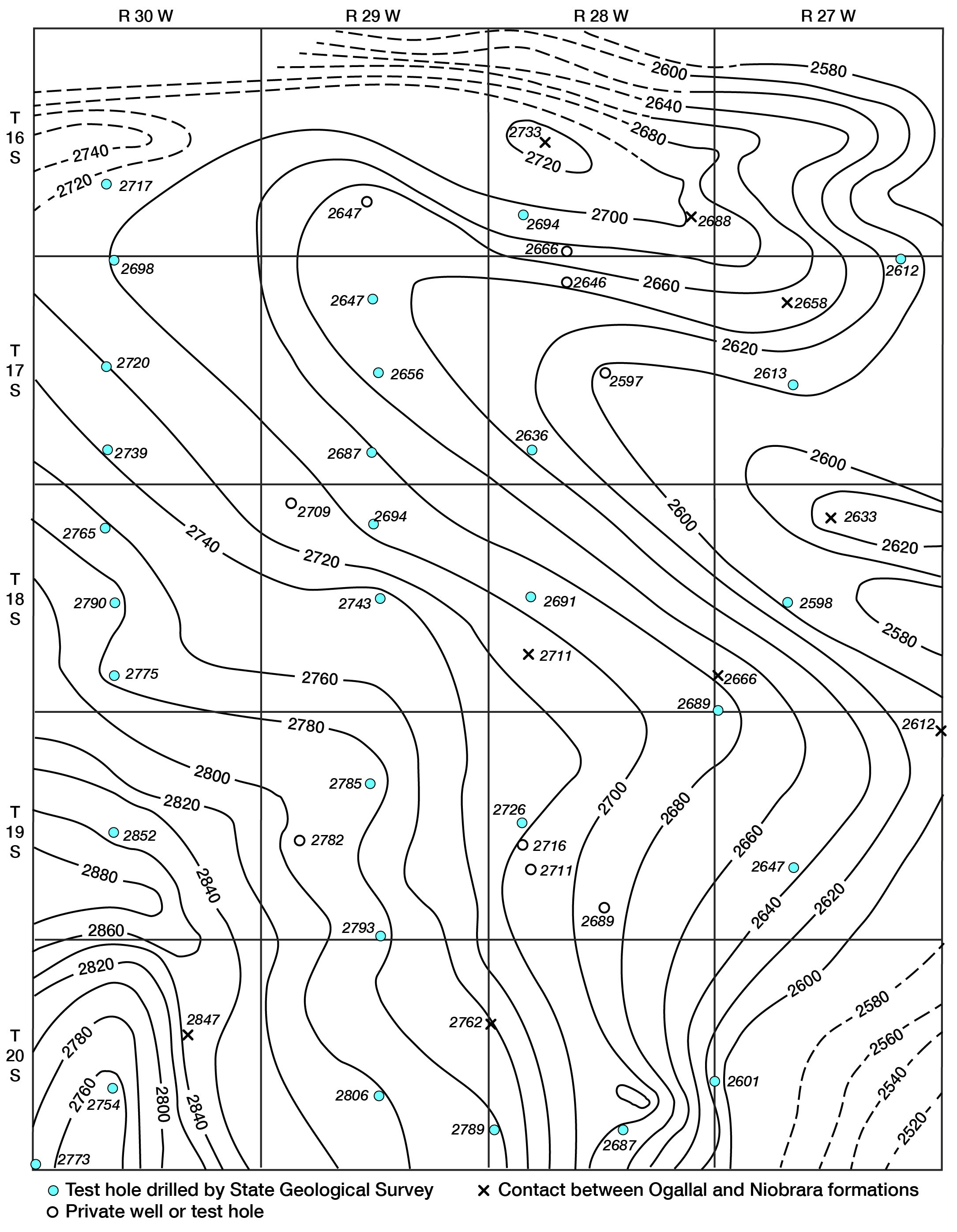
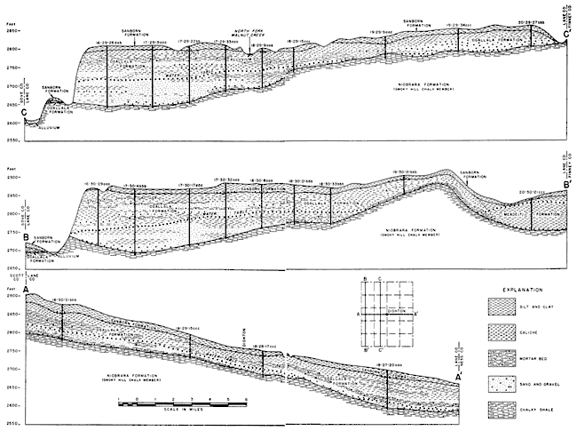
Fig. 6--Geologic cross sections through Lane County. A larger version of this figure is available.
During the Pliocene Epoch a reversal from stream erosion to stream deposition occurred in the area of western Kansas. Widely shifting streams from the Rocky Mountains made extensive deposits of sand, gravel, silt, and clay over the High Plains surface. By the end of the Tertiary period the sediments of the Ogallala formation extended in a broad alluvial plain from the Rockies perhaps as far as the Flint Hills in Kansas (Smith 1940, p. 86).
Quaternary Period
Pleistocene Epoch--During early Quaternary time uplift of the land occurred and streams were rejuvenated. A period of erosion followed but it was less severe than that preceding the deposition of the Ogallala for the resulting surface had slight relief as compared to the pre-Ogallala surface. Later, sedimentation was resumed and valleys cut in the Ogallala were filled with sediments that comprise the Meade formation. Deposits lying in a slightly southwesterly trending basin or depression in southwestern Lane County are tentatively classified as the Meade formation. Here the formation consists mainly of silt and clay, with a small amount of sand and gravel at the base. In the NW sec. 3, T. 16 S., R. 29 W. a terrace remnant along a tributary to the Smoky Hill is also tentatively classified as Meade formation. In later Pleistocene time aggrading and laterally shifting streams produced deposits of silt, sand, and gravel which constitute part of the Sanborn formation. These deposits are not extensive over Lane County and it is probable that no through-flowing streams crossed the county during Pleistocene time. Apparently in the latter part of the Pleistocene Epoch there was a climatic change and winds became very strong. A layer of windblown silt (loess) was deposited over the area to depths as much as 25 feet. The loess and underlying sand and gravel were named Sanborn formation by Elias (1931, p. 163).
In a small area in southwestern Lane County and in adjacent Finney and Scott counties, the surface is mantled by dune sand. Its age is not known but it is probable that accumulation of the sand started in late Pleistocene time. The sand was probably derived from Pliocene and Pleistocene deposits and carried to its present location by strong winds. Much of the sand may have been derived from the strand flats of a lake that formerly occupied a depression in southeastern Scott County now known as Dry Lake. There is a similar depression in southwestern Lane County and it is likely that much sand was derived from the shores of the lake that it probably once contained.
During Recent time the county has undergone erosion that has formed much of the present topography. Some of the small intermittent streams, which flow periodically in Lane County, have cut down through Pleistocene and Pliocene deposits and deeply into the underlying Cretaceous rocks, exposing the Niobrara formation in many places and the Carlile shale in small, isolated outcrops in the southeast corner. A narrow band of alluvium has been deposited along most of these streams.
During Recent time many shallow depressions have developed on the surface of Lane County and of surrounding areas in the High Plains. The depressions range in diameter from a few yards to about half a mile and may or may not contain water. Most of them hold water after periods of heavy rainfall until the water has evaporated or moved downward to the water table.
The origin of the depressions is not known, but three main theories of origin have been offered. Darton (1916, pp. 36, 37) referred to some of these High Plains depressions as "buffalo wallows" and explained their origin by the action of buffalos and wind. He believed that the depressions were started by buffalos at wet, salty, or alkali spots, and that they were excavated by tramping hoofs and by mud sticking to the shaggy coats of the animals during wet periods. During dry periods, the sod cover having been broken exposing the soil, wind scour became the dominant mode of erosion. Whereas this hypothesis might account for some of the small shallow depressions, it probably would be inadequate for the larger, more extensive depressions.
For the large basins in the area of Permian bedrock or where the Tertiary cover was thin, Johnson (1901, pp. 702-712) advocated an origin of solution of soluble beds of the Permian followed by collapse of the overlying beds and development of surface depressions. This theory explains satisfactorily the origin of large sinks such as the Salt Well in Meade County and the Big Basin and St. Jacob's Well in western Clark County, but would not adequately explain the origin of depressions--especially small, shallow, round, or oval depressions--in areas of thick Cretaceous bedrock as in Lane County.
Smith (1940, p. 171) stated that--
. . . These depressions are probably a result of subsidence due to solution of salt or gypsum beds in Permian or early Mesozoic formations, or possibly in the case of the Scott-Finney depression, of calcareous beds in the Cretaceous.
Johnson (1901, p. 711 ) considered that--
. . . the innumerable upland basins, especially where the floor is Cretaceous to great depths, are clearly ascribed to grain-by-grain processes of readjustment and compacting, at work within the Tertiary only.
Concerning the mechanics of the compaction process he stated (pp. 703, 704):
Appearances indicate basining of the alluvial source as a consequence, first, of rain water accumulation in initial faint unevennesses of the plain; second, of percolation of this ponded surface water downward to the ground water in largely increased amount from these small areas of concentration, rather than from the surface uniformly, with the result that the alluvial mass is appreciably settled beneath the basins only. The inference is at once suggested that this settlement takes place as the combined effect of mechanical compacting of the ground particles and the chemical solution of the more soluble particles. Finally, these effects should be cumulative, resulting in the growth noted, since, with enlargement of the basins, concentration of rain water within them will be on an increased scale.
Johnson's hypothesis has not been widely accepted, but Latta (1944, p. 45) states that it accounts more plausibly than other theories for the origin of the small, shallow depressions in Finney County. Likewise, Frye (1945, p. 31) accepts this theory of origin for surface depressions in Thomas County. Probably many of the depressions found in Lane County were formed in this manner, although it would be impossible to prove this with the evidence now available.
Prev Page--Geography || Next Page--Ground water occurrence
Kansas Geological Survey, Geology
Placed on web Jan. 18, 2008; originally published Sept., 1951.
Comments to webadmin@kgs.ku.edu
The URL for this page is http://www.kgs.ku.edu/General/Geology/Lane/04_geol.html