![]()
Prev Page--Douglas and Shawnee Groups || Next Page--Structural Geology
Stratigraphy of Outcropping Rocks, continued
Quaternary System-Pleistocene Series
Pre-Kansan Deposits
Leached and oxidized gravel consisting chiefly of chert pebbles 1/4-inch to 2 inches in diameter in a reddish sandy clay matrix is exposed at several places east and south of Lawrence and in the vicinity of Eudora. Although the gravel deposits consist chiefly of chert pebbles, all exposures examined contain erratics or rocks foreign to the pre-Pleistocene bedrock of the drainage system. Chert gravels are exposed in road cuts along Kansas Highway 10 in the SW sec. 4, NE sec. 9, and NW sec. 10, in T. 13 S., R. 20 E.; in pasture land west of Haskell Institute in the NW sec. 7, T. 13 S., R. 20 E.; and south of Wakarusa River along Haskell Avenue in the SE sec. 19, T. 13 S., R. 20 E. These chert gravels rest on Pennsylvanian bedrock at altitudes of 880 to 900 feet. Erratics make up a significant part of the gravel, ranging from about 1 percent to perhaps 40 percent locally. The extensive distribution of chert gravel at this altitude indicates that these bodies are remnants of deposits of a stream that flowed at this level prior to invasion of the area by the Kansan glacier. Chert gravels containing more than a very small percentage of erratics are judged to have been reworked by the Kansan glacier and glacial melt water.
Chert gravel containing very sparse erratics and overlain by red Kansan water-laid silts rests on Pennsylvanian shale at an altitude of about 840 feet about 100 feet south of Kansas Highway 10, in the NE cor. sec. 7, T. 13 S., R. 21 E., near Eudora. Chert gravels containing numerous erratics overlie the Stanton Limestone at an altitude of about 850 feet and are overlain by Kansan silts and sands at the eastern boundary of the county along Kansas Highway 10.
The leached and oxidized condition of these gravels, their topographic position, and their position below Kansan drift indicate that they are probably early Pleistocene in age. Chert-gravel deposits containing few or no erratics and lying at altitudes of 930 to 950 feet along the north bluff of Kansas River in Leavenworth County in sec. 19, 20, and 29, T. 12 S., R. 21 E., may be of early Pleistocene or late Tertiary age.
As outwash from the Nebraskan glacier has not been conclusively demonstrated to have been discharged into the Kansas River drainage system (Frye and Walters, 1950; Frye and Leonard, 1952), the chert-gravel deposits containing only very small amounts of erratics probably represent late Tertiary stream deposits or early Kansan or Nebraskan deposits that were only slightly contaminated with northern erratics by Kansan proglacial streams. Chert-gravel deposits, previously cited, which are found south of Wakarusa River, containing more than very small amounts of erratics are judged to have been modified by outwash associated with the Kansan glacier or by glacial ice.
No uncontaminated chert-gravel deposits large enough to map and clearly older than Kansan were observed by the writer, and none are shown on Plate 1.
Kansan Stage
Deposits of Kansan age include lacustrine, fluvial, and glacial sediments. They are complex and have a greater vertical distribution in the topography than other Pleistocene deposits, chiefly because of the advance and retreat of a continental ice sheet into and from the area.
Drainage systems were disrupted and in particular the Kansas River system was greatly enlarged.
The general classification of Kansan and other Pleistocene deposits used in Kansas is shown in Figure 6.
Figure 6.--General classification of Kansas Pleistocene deposits.
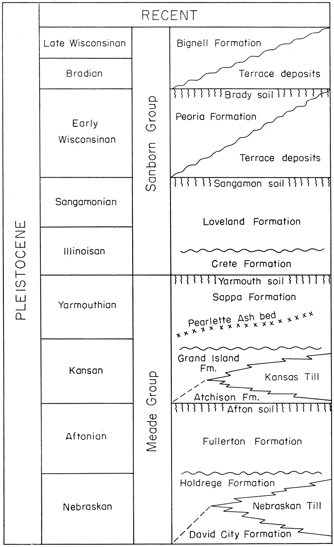
Pro-Kansan outwash deposits are defined as the Atchison Formation, and where overlain by Kansas Till they can be readily identified. The Atchison Formation is not recognized outside the glaciated area. Retreatal-Kansan outwash deposits comprise the Grand Island and Sappa Formations. The Grand Island Formation consists chiefly of coarse gravel and sand, which locally interfinger with Kansas Till. The Sappa Formation, consisting chiefly of silt, conformably and gradationally overlies the Grand Island Formation and represents deposits formed during the later phase of glacial retreat. Outwash in this area is judged to be associated with the retreatal phase of glaciation, although locally, stratified Kansan deposits cannot clearly be identified as pro-Kansan or retreatal-Kansan in the terminal area.
Kansas Till
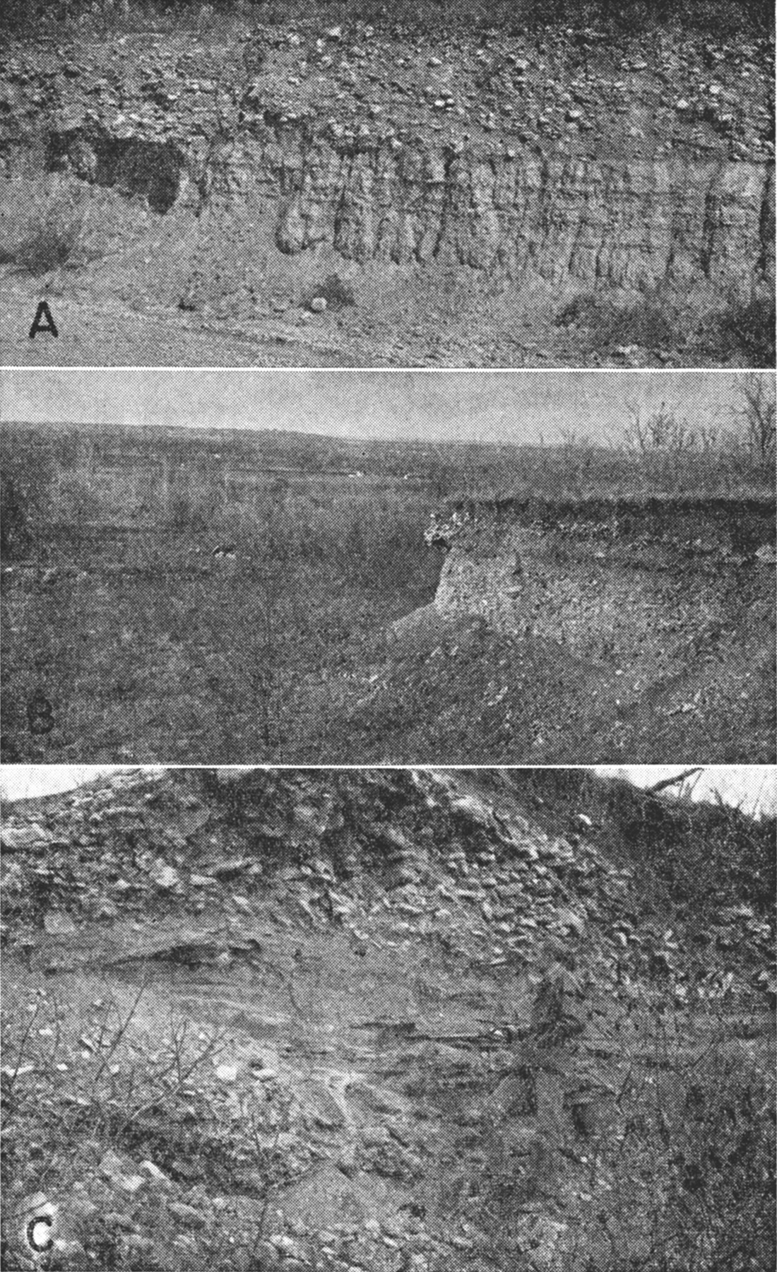
Areas mapped as Kansas Till (Qkt) on Plate 1 include sediments that were probably deposited directly from glacial ice. The till is dominantly unstratified and unsorted. Most of the till in the upland between Kansas River and Wakarusa River is clay and probably accumulated by lodgment from the base of the ice. Such deposits are well exposed along U. S. Highway 40 in the NE cor. sec. 26, T. 12 S., R. 18 E., and in pasture ditches in the SW sec. 2, T. 13 S., R. 17 E. Other till deposits accumulated by dumping or being let down by slow wastage of the ice (superglacial ablation moraine). Such till is characterized by less clay and silt in proportion to gravel and sand, having been repeatedly washed by trickles of melt water during melting of the glacial ice. Southwest of Lawrence one such till deposit (Pl. 7A) overlying undisturbed lacustrine silt is well exposed in the SW cor. sec. 2, T. 13 S., E. 19 E. Locally, small bodies of stratified sand and gravel. occur in the till in high upland positions, as in the NW SE sec. 24, T. 12 S., R. 18 E. All gradations between unstratified and unsorted till containing much clay to well-stratified and sorted glacial sands and gravels may be found in the area, and in many places where exposures are poor or lacking it is difficult to determine whether a deposit should be classed as till or as associated sorted and stratified glacial deposits (Atchison, Grand island, and Sappa Formations).
Undoubtedly there are small areas of thin till that are not shown on Plate 1 because the deposits were too poorly exposed to be identified and delineated.
Plate 7—A, Kansas Till overlying varved lacustrine beds of Atchison Formation, SW SW sec. 2, T. 13 S., R. 19 E.; B, Coarse Kansan gravels capping Shank Hill in the Wakarusa River valley, NE SE sec. 26, T. 13 S., R. 19 E.; C, Closeup view of coarse, poorly sorted Kansan deposits capping Shank Hill.
Kansan Glaciofluvial and Glaciolacustrine Deposits
Glaciofluvial and glaciolacustrine deposits (Atchison, Grand Island, and Sappa Formations) associated with the Kansan glacier are abundant and occur in high, intermediate, and low topographic positions in northern Douglas County. These deposits, mapped on Plate 1 as Qko, include the Atchison, Grand Island, and Sappa Formations and locally some till, but are mostly Grand Island and Sappa Formations. The predominance of stratified deposits rather than till in the terminal area of the glacier indicates that the Kansan glacier at its climax may have been a slowly flowing, rapidly melting ice mass. Much of the sediment carried by glacial ice, which ,originally may have been deposited as till or moraine, was subsequently modified by glacial melt water to produce stratified glacial deposits.
At its maximum extent the glacier probably occupied both the Kansas and the Wakarusa River valleys and the intervening divide, as indicated by scattered deposits of till on the divide between these rivers and by the presence of stratified gravels containing erratics at several high points in the topography south of Wakarusa River. Todd (1909) in discussing the history of Wakarusa River also noted and discussed the distribution and features of Kansan deposits in Douglas County. Schoewe (1930, fig. 1) depicted the maximum extent of the ice sheet in Douglas County. Where these stratified gravels are well exposed, as at Shank Hill in the SE sec. 26, T. 13 S., R. 19 E., (Pl. 7B, C) and in several road cuts, they consist of poorly sorted sand and gravel ranging in thickness from about 2 feet to 30 feet. The thin deposits are leached and consist chiefly of chert, quartz, and igneous and metamorphic rocks from the north. The igneous and metamorphic rocks include pink and red Precambrian Sioux Quartzite derived from outcrops in Southwestern Minnesota, northwestern Iowa, or southeastern South Dakota. Sioux Quartzite is the most distinctive of the northern rock types. Greenstone and gray granite from outcrops in northern Minnesota and western Ontario are common also. The thicker deposits are leached only in the upper part and contain chiefly limestone and other local rock types. A series of these deposits may be traced from the area southwest of Clinton eastward and southward across the county to a point near Clearfield, thence eastward into Johnson County, as follows: NW cor. sec. 33, T. 13 S., R. 18 E. (altitude 1,020 ft.), SE sec. 34, T. 13 S., R. 18 E., and NE sec. 3, T. 14 S., R. 18 E. (±1,070 ft.), N1/2 sec. 30, T. 13 S., R. 19 F. (±1,030 ft.), SE sec. 26, T. 13 S., R. 19 E. (1,007 ft.); a series of irregular, narrow linear and knob bills in sec. 29 and 30, T. 13 S., R. 20 E. (900 to 950 ft.); and a series of irregular, narrow linear and knob hills trending directly southeast from the SE NE sec. 33, T. 13 S., R. 20 E., to the center of the north side of sec. 17, T. 14 S., R. 21 E. (900 to 1,010 ft.). These gravels, judged from their areal distribution, topographic position, form, structure, size, and degree of sorting, are unquestionably ice-contact deposits laid down in and along the margin of the ice. Probably a series of streams locally flowed on Pennsylvanian bedrock along the glacier front. Streams also flowed in marginal crevasses on or within the ice to form stratified drift. Many short-lived marginal lakes were formed in blocked northward-flowing tributaries of Kansas River and Wakarusa River during the maximum advance of the glacier.
As the glacier became stagnant or nearly stagnant, marginal and superglacial streams were gradually replaced by englacial and subglacial streams flowing at lower altitudes. A glacial stream entered Douglas County along, the west boundary in sec. 23, T. 17 S., R. 13 E., and flowed generally eastward for about 4 miles along the north side of the present Wakarusa River. The deposits of this stream now form a ridge of gravel, sand, and silt 30 to 40 feet thick locally and having a crest altitude of about 990 feet. Along parts of the stream course, erosion has reduced the ridge to a boulder belt only a few feet thick. To the east these deposits are found in a belt 1/2 to 1 mile wide trending eastward through Clinton at an altitude of ±960 feet as a filled abandoned valley (B-B', Pl. 3). South of Lawrence in sec. 11 and 12, T. 13 S., R. 19 E., these deposits form a prominent ridge having a crest altitude of slightly more than 900 feet (E-E', Pl. 3). The lower and middle parts of the deposit forming this ridge are composed of boulders, gravel, and sand; the deposit becomes finer upward, as indicated by logs of test holes and water wells. Locally the gravels are chiefly chert, but abundant limestone boulders and erratics from the north are common also. Road cuts along U. S. Highway 59 have exposed unstratified bouldery and gravelly clay (till) at the top of the deposits. The distribution, topographic position, structure, and lithology of Kansan deposits probably result from the following sequence of events. During Nebraskan and early Kansan time prior to the advance of the Kansan glacier south of Kansas River, an eastflowing stream occupied the Wakarusa Valley and deposited chert and limestone gravels. During early Kansan time the stream probably entrenched itself, and for a short time proglacial melt water flowed down the valley, contributing small numbers of erratics to the chert and limestone gravel before being overridden by the glacier. As the glacier became nearly stagnant and the volume of melt water increased, a subglacial stream became re-established in much of the preglacial Wakarusa Valley. Much of the coarse rock material carried by the ice became stream load as the nearly stagnant ice melted, and the stream bed was alluviated. Subsequently, as the glacier continued to dissipate, a major glacial stream became established in the Kansas River valley, perhaps capturing much of the drainage system of Wakarusa River. Locally, till was deposited on glacial-stream gravel in parts of the Wakarusa Valley. The presence of till on outwash gravels may indicate minor readvances of the ice near its margin in the Wakarusa Valley. Till and fluvial deposits are recognized also southeast of Lawrence on the upland area along the divide between the Kansas and Wakarusa River valleys. Probably they have an interfingering and complex relationship similar to that of described deposits in sec. 11 and 12, T. 13 S., R. 19 E. Schoewe (1930b, p. 72), studying excavations in NE in glacial deposits in the NW sec. 7, T. 13 S., R. 20 E., at Haskell Indian Institute, recognized two tills, the slightly different lithologies of which probably resulted from minor fluctuations of the Kansan glacier. Subsequent Pleistocene studies in northeastern Kansas indicate that only the Kansan glacier reached as far south as the Wakarusa Valley.
Lacustrine deposits of silt and sand deposited in temporary lakes resulted from derangement of early Kansan drainage by glacial ice and glacial deposits at the climax of Kansan glaciation. One such varved lacustrine deposit exposed on the west side of a small nob bill in the SW cor. sec. 2, T. 13 S., R. 19 E., (Pl. 7A) is at least 7 feet thick, and consists of 24 or more pairs of alternating thin dark-brown and thicker light-gray beds of silt and sand overlain by about 6 feet of unstratified and unsorted limestone gravel. The limestone gravel overlying the lake silt has many of the characteristics of superglacial till. Another varved lacustrine deposit is partly exposed at the base of a road cut 500 to 700 feet north of the SE cor. sec. 8, T. 14 S., R. 21 E. About 2 feet of alternating thin red-brown and thicker gray beds of silt and sand consisting of at least 8 varves is overlain by I to 2 feet of very fine red-brown sand and 3 to 10 feet of slightly bedded till. The till consists chiefly of sand, gravel, and cobble-size fragments of red-brown sandstone. just north of the map area another pro-Kansas lacustrine deposit consisting of at least 22 feet of tan and gray laminated silt and sand overlain by Kansas Till is well exposed along Kansas Highway 32 in the SW sec. 14 and NW sec. 23, T. 12 S., R. 20 E., Leavenworth County.
Although temporary proglacial lakes must have been formed at many places as a result of blockage of Wakarusa and Kansas Rivers and their tributaries by the advancing Kansan glacier, exposures of lacustrine deposits are rare. The lacustrine deposits in general probably were thin and may have been incorporated in or destroyed by the advancing glacier. Where these lacustrine deposits were not capped by a protective cover of till or gravel, they probably were destroyed by erosion subsequent to the retreat of the ice.
The most extensive area of Kansan glaciofluvial and glaciolacustrine deposits in Douglas County is in the Hesper area south of Eudora and east of Little Wakarusa Creek and extends eastward to Kill Creek in Johnson County. This 50-square-mile area, south of Kansas River, is covered with glacial drift except where post-Kansan streams have cut through the deposits into underlying Pennsylvanian rocks. Scboewe (1930a) and Hoover (1936) regarded Kansan deposits in the Hesper area as reworked till. Dufford (1958), working in the area north of Hesper, classed the same deposits as part of the Menoken Terrace deposits, chiefly retreatal-Kansan outwash. In this study it was found that both outwash and till are included.
The early Kansan topography in the Eudora-Hesper area was a lowland, developed on the soft shales and sandstones of the Pedee and Douolas Groups, flanked by higher limestone cuestas both to the east and west. As the composition of till strongly reflects the character of the bedrock exposed upstream, it would be expected that sand, silt, and clay of local derivation would characterize any till or reworked till deposits in the area. The southernmost deposits of till in Douglas County are in this area (sec. 17, T. 14 S., R. 21 E.), indicating that the glacier must have overridden most of the area north of section 17 at its maximum extent. Many of these Kansan deposits are partly stratified. Basal deposits commonly are gravel or sand and locally are well sorted and clean but elsewhere are clayey and poorly sorted. Clayey and silty sand, or sandy clay, containing scattered gravel and cobbles, compose the upper part of these Kansan deposits in much of the area south of Eudora. Such a sequence is not everywhere present, because locally the deposits consist of unstratified sandy and gravelly silt and clay.
Kansas River has a surface altitude of about 780 feet and the surface of the Kansas River alluvium is at an altitude of about 800 feet in the vicinity of the north end of cross section F-F' (Pl. 3) just east of Eudora. Kansan deposits along the south bluff have surface and base altitudes of about 885 and 855 feet, respectively. Southward, the surface and base of these Kansan deposits rise gently about 100 feet in a distance of about 7 1/2 miles, forming a gently north sloping plain (Pl. 8A). This gently sloping plain is the principal geomorphic feature of the area, but locally there are smaller geomorphic features that are conspicuous. One such feature is a prominent northeastward-trending ridge 20 to 30 feet high and about 1 1/2 miles long, which crosses the east county boundary into Johnson County (sec. 26, 27, and 34, T. 13 S., R. 21 E.). An auger hole along the crest of the ridge at an altitude of about 941 feet, and less than 1/4 mile into Johnson County, penetrated 52 feet of sandy clay and sand. Adjacent to the ridge on the northwest is a series of small, obscure roughly symmetrical mounds. Although the origin of these features is uncertain, they may be depositional features associated with the wasting phase of the glacier.
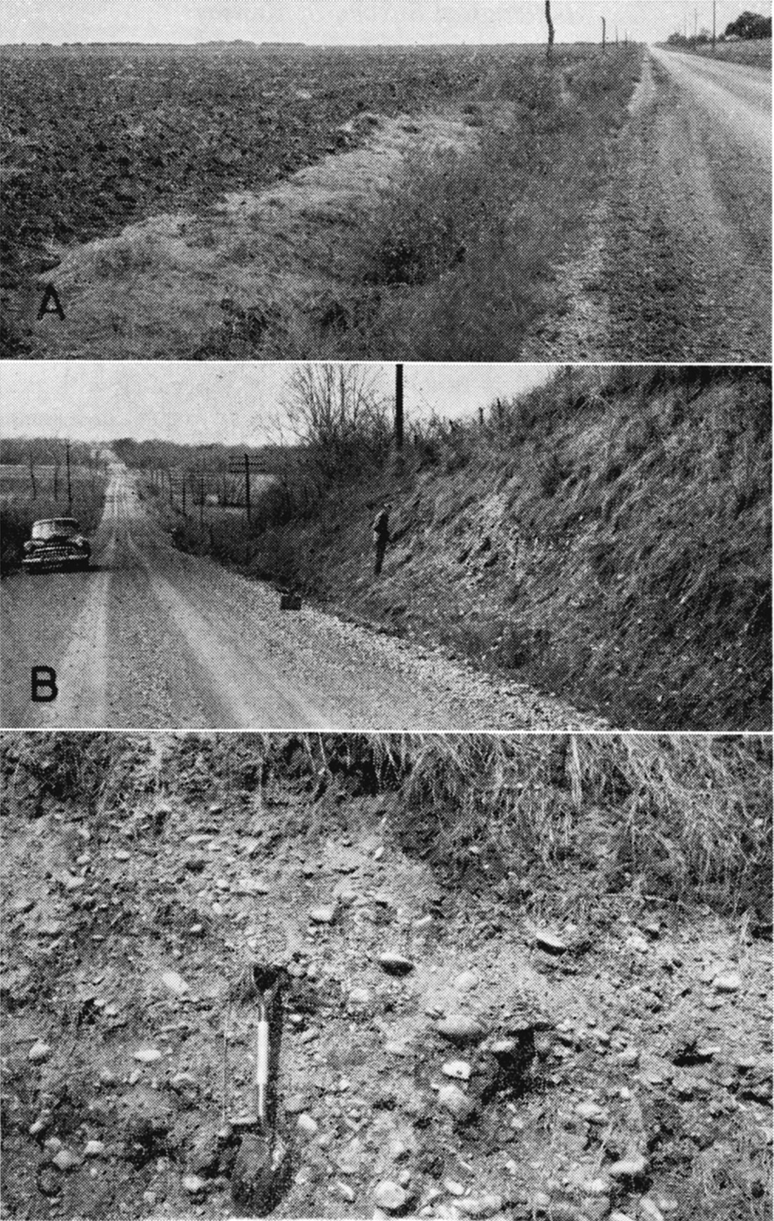
Plate 8—A, Part of extensive plain in Hesper area developed on Kansan glaciofluvial deposits. View south from near center W. side NE sec. 27, T. 13 S., R. 21 E.; B, Toe of Menoken Terrace along north side of Kansas River valley, S. side SW SW sec. 9, T. 12 S., R. 20 E. Terrace-shale contact about at position of automobile. Newman Terrace surface in background; C, Poorly sorted Grand Island gravel and sand in basal Menoken Terrace deposits exposed just right of center in 8B.
Because of the various features of Kansan deposits south of Eudora, there seems to be no sharp dividing line between till and stratified drift; rather, one grades into and interfingers with the other. Most of the sediments are judged to have been deposited prior to the retreat of the Kansan glacier to a position north of Kansas River, and many of the stratified deposits are time equivalents of and related to the stratified deposits found in the Wakarusa River valley. The Grand Island and Sappa Formations compose the bulk of the deposits.
When the Kansan glacier retreated north of the Kansas River valley, large volumes of melt water discharged coarse, poorly sorted gravels (Pl. 8B, C) into the valley-the principal ice-marginal stream in the area-forming deposits 20 feet thick or more, which locally along the north side of the valley interfinger with Kansas Till (Davis and Carlson, 1952). The river gravels are nearly identical with gravel in the till. Dissipation and northward retreat of the glacier resulted in rapid alluviation of the valley with progressively finer sediments. At places, more than 60 feet of leached and oxidized reddish-brown sand, silt, and clay make up the upper part of this alluvial fill.
Most of the retreatal-Kansan deposits that filled the Kansas River valley have been removed by post-Kansan erosion, but remnants in the form of terrace deposits occupy an area of about 3 square miles along the south side of the Kansas River valley between Lawrence and Lakeview and a similar area on the north side of the valley. These Kansan terrace deposits are deeply dissected and have only approximately accordant summits ranging in altitude from about 890 to 930 feet. The combined areas have been named the Menoken Terrace (Davis and Carlson, 1952), and retreatal Kansan deposits (Grand Island and Sappa Formations) have been mapped as Menoken Terrace deposits in parts of the Kansas River valley (Davis and Carlson, 1952; Dufford, 1958; Beck, 1959). The name Menoken Terrace is used only as a geomorphic term in this report for a terrace on sediments of Kansan age in the Kansas River valley.
Illinoisan Stage
During the Illinoisan Stage, continental glaciers were more remote from Kansas than during other Pleistocene stages. Indirect effects were the erosion of much of the previously deposited Kansan deposits in the Kansas River valley and its tributaries and the entrenchment of the river to a depth of 50 to 60 feet below basal Kansan deposits (E-E', Pl. 3). Then followed aggradation of the valley to a depth locally of 70 feet or more. Minor amounts of loess were deposited on uplands adjacent to the Kansas River valley.
Deposits of Buck Creek Terrace
An alluvial fill deposited in late Illinoisan time and subsequently dissected has been named the Buck Creek Terrace deposits (Davis and Carlson, 1952) and is mapped as Qtbc on Plate 1. Crete and Loveland Formations are names applied to the coarse basal deposits and the fine upper part, respectively. Crete sand and gravel is thin, generally less than 10 feet, although one test hole (13-20-20bc) penetrated 28 feet of silty and clayey sand. The Loveland Formation constitutes most of the terrace fill and is at least 62 feet thick locally (test hole 13-19-13bcc). The Loveland Formation is chiefly reddish or tan silt, sandy silt, and clay and is gradational into the underlying Crete.
In addition to water-laid deposits in the Buck Creek Terrace, the Loveland Formation contains thin eolian deposits (loess) locally. Loveland loess is generally less than 5 feet thick and is restricted to the bluffs bordering the Kansas River valley. This loess was not mapped.
The Sangamon soil, which is well developed on Buck Creek Terrace deposits, is characterized by its reddish color and thick clayey B horizon.
Wisconsinan and Recent Stages
The Newman Terrace deposits and alluvium were deposited in the valleys during Wisconsinan and Recent time, and thin loess of the Peoria Formation was deposited locally on the uplands. The Wisconsinan glaciers, although never nearer Kansas than southern Iowa, discharged large volumes of melt water into the Missouri River valley. Associated climatic changes indirectly resulted in a period of downcutting followed by aggradation of streams in this area.
Peoria Formation
The Peoria Formation, of early Wisconsinan age, is composed of thin discontinuous light-gray to tan eolian silt deposits on the uplands in this area. The formation is thickest along bluffs of the Kansas River valley, where locally it is 5 to 10 feet thick, but elsewhere in the area it is generally less than 5 feet thick. Because of the small extent of areas in which loess of the Peoria Formation is more than 5 feet thick and because of the difficulty of identifying and delimiting these areas, owing to the vegetative cover, the loess is not shown on Plate 1. It is well exposed and has a thickness of 5 feet or more along the Kansas Turnpike in sec. 18, T. 12 S., R. 18 E., and in the west face of the quarry in the NE sec. 4, T. 13 S., R. 21 E. It is 5 feet thick in test hole 13-20-5cb where it overlies thin Loveland Formation and Kansas Till.
Deposits of Newman Terrace
The cycle of erosion and alluviation initiated in early Wisconsinan time resulted in deepening the bedrock floor of the Kansas and Wakarusa River valleys 20 to 50 feet below the basal Illinoisan deposits. The terrace underlain by these early Wisconsinan deposits is the Newman Terrace, generally 30 to 46 feet below the Buck Creek Terrace in the Kansas and Wakarusa River valleys.
The basal Newman Terrace deposits in the Kansas River valley consist chiefly of gravel, which is much coarser than sediments now being carried by Kansas River (Wyman, 1935; Davis and Carlson, 1952). The sediments grade upward from cobbles through sand to a clayey silt at the surface. In the Kansas River valley, where the Newman Terrace deposits are thickest, coarse sediments 40 to 50 feet thick are overlain by a similar thickness of dark sandy, silty, and clayey sediments. In the Wakarusa River valley the coarse sediments generally are less than 10 feet thick and the valley fill is composed chiefly of silt and clay (E-E', Pl. 3). The basal part of the Newman Terrace deposits is not exposed anywhere in the area and has not been dated on the basis of fossils. Its erosional position below Illinoisan Terrace deposits and its stratigraphic position below deposits of late Wisconsinan to Recent age that form the upper part of the alluvial fill indicate that its age is early Wisconsinan.
The Newman Terrace typically is a flat, poorly drained surface bordered by low natural levees. Unlike the topographically lower surface of the alluvium, it is not marked by old meander scars but is nearly featureless, and requires artificial drainage in many areas to allow cultivation. The upper 40 feet of deposits underlying the Newman Terrace are similar to sediments transported by Kansas River at the present time (Davis and Carlson, 1952, p. 229).
The Newman Terrace and alluvium together constitute the Kansas River flood plain. Slightly less than half the flood plain in the area from Eudora westward to Topeka, where the valley is wide, is the Newman Terrace. Eastward from Eudora to Kansas City the valley narrows where it is cut in rocks of the Lansing and Kansas City Groups, and the Newman Terrace, preserved only locally, forms less than 10 percent of the flood plain. In the Wakarusa River valley and many of the smaller tributaries to Kansas River, the Newman Terrace forms 90 percent or more of the flood plain. The Newman Terrace is about 20 feet above the average low-water stream level along Kansas River and much of Wakarusa River. The terrace surface is still being raised by slight vertical accretion each time it is covered by floodwaters. Studies by Davis and Carlson (1952) indicate that the 1951 flood added an average of about 5 mm of silt and silty clay to the Newman Terrace in the Kansas River valley. Ordinary floods cover the Newman Terrace in the Wakarusa River valley to depths of a few inches to a few feet, but only severe floods cover this terrace in the Kansas River valley and then may inundate only parts of the terrace, natural levees and high points on the terrace remaining above flood level.
Alluvial fills in tributaries to Marais des Cygnes River in southern Douglas County have not been firmly correlated with those of Kansas River. The alluvial fills forming the flood plains of these tributaries seem to correspond to the Newman Terrace and alluvium of Kansas River and its tributaries, however. Undifferentiated alluvial deposits, chiefly Wisconsinan and Recent in age but locally including Illinoisan deposits, in small tributaries to Marais des Cygnes and Kansas Rivers are shown on Plate 1 (Qtu).
Alluvium
Deposits mapped as Alluvium along Kansas River and its tributaries are late Wisconsinan and Recent in age and, together with the Newman Terrace, form the river flood plain. In the Kansas River valley, alluvium constitutes somewhat more than half the flood plain. In the valley of Wakarusa River and other tributaries to Kansas River, alluvium forms a very minor part of the flood plain. Along Wakarusa River above Coal Creek, alluvium, exclusive of the stream-channel deposits, ranges in width from 0 to about 150 feet, but because of its scattered and very limited distribution it is not shown separately on Plate 1.
In the Kansas River valley the alluvium is chiefly sand and silt similar to the sediments carried by the river at the present time. This alluvial surface is marked by meander scars and abandoned channels, and is irregular, commonly having a relief of 10 or 12 feet. Davis and Carlson (1952), McCrae (1954), Dufford (1958), and Beck (1959) have mapped, or considered mapping, during the course of field work in this and adjacent areas of the Kansas River valley, two or more surfaces within parts of the flood plain mapped as Alluvium in this report.
Davis and Carlson (1952, p. 215), in considering whether more than one surface (alluvium) could be mapped below the Newman Terrace, stated that "the point-bar accretion slopes in abandoned meanders are so gentle that they appear horizontal and unless carefully surveyed could easily be mistaken for terraces." Dufford (1958) also recognized that these surfaces (below the Newman Terrace) are not horizontal and illustrated this with longitudinal and transverse profiles. He also stated (p. 28), "...unfortunately these [surface configuration, soil development, and elevation] contrasts are not everywhere conspicuous among the intermediate surfaces themselves, and no attempt has been made to differentiate them in mapping." Dufford recognized four surfaces lower than the Newman Terrace, one 3 feet below the Newman Terrace, one 4 feet below the Newman Terrace, a "youthful floodplain" surface, and a "modern active floodplain." The upper two of these four surfaces be named the "intermediate surface complex." All four exhibit an appreciable variation in altitude. Prominent scarps of these surfaces below the Newman Terrace may be as much as 10 feet high locally, but laterally they diminish and may become imperceptible.
The surface characteristics of the deposits below the Newman Terrace indicate that they are the result of gradual downcutting during progressive but nonuniform downstream migration of meanders. Moreover, the radii of curvature of the meander scars on the alluvial deposits below the Newman Terrace have increased during the later stages of development. The Alluvium and Newman Terrace, as mapped on Plate 1, can be readily differentiated in the field.
Prev Page--Douglas and Shawnee Groups || Next Page--Structural Geology
Kansas Geological Survey, Geohydrology of Douglas County
Web version Aug. 1999. Original publication date Dec. 1960.
Comments to webadmin@kgs.ku.edu
The URL for this page is http://www.kgs.ku.edu/General/Geology/Douglas/strat06.html