![]()
Prev Page--Lansing and Pedee Groups || Next Page--Quaternary rocks
Stratigraphy of Outcropping Rocks, continued
Pennsylvanian System--Virgillian Series
Douglas Group
Stranger Formation
The Stranger Formation is divided into five members designated, in ascending order, the Tonganoxie Sandstone, the Westphalia Limestone, the Vinland Shale, the Haskell Limestone, and the Robbins Shale. The formation rests unconformably on various parts of the Weston Shale and Stanton Limestone. Its maximum thickness is about 160 feet, but locally the Stranger Formation is absent and the Ireland Sandstone member of the Lawrence Shale directly overlies the Weston Shale.
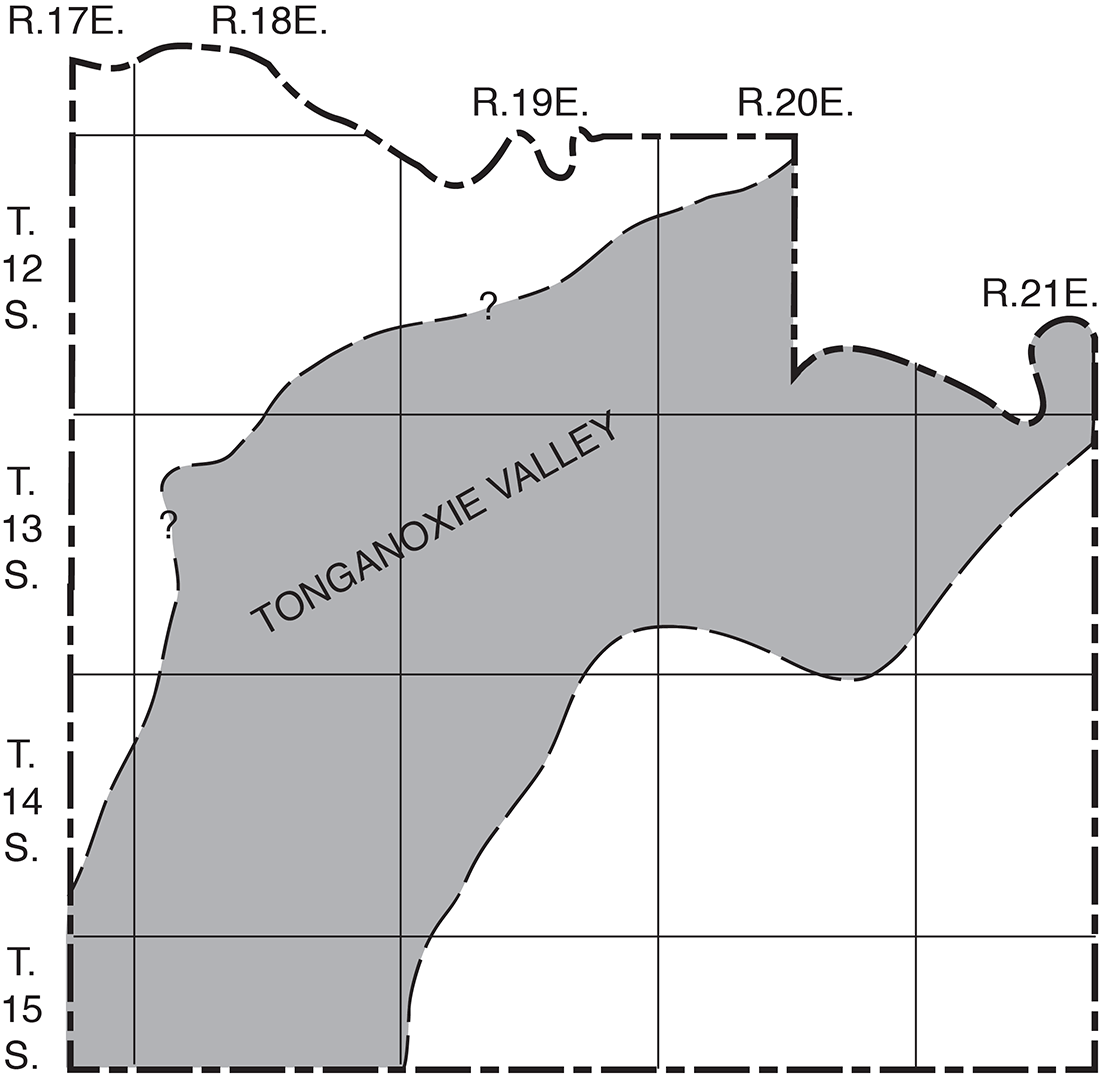
Tonganoxie Sandstone member--The Tonganoxie Sandstone member in this area is believed to be a non-marine sandstone that occupies an erosional river valley cut into the Weston Shale and Stanton Limestone. Lins (1950) described the lithology, origin, and environment of the Tonganoxie Sandstone member in its outcrop area in Douglas, Leavenworth, and Wyandotte Counties. The erosional valley trends southwestward and is 14 to 20 miles wide. The City of Lawrence overlies about the middle of the valley. According to Lins, the Tonganoxie Sandstone member contains four distinct lithologic units, which, in ascending order are conglomerate, sandstone, Shale, and coal. Sanders (1957), in a study of the sandstones of the Douglas and Pedee Groups in northeastern Kansas, concluded that the ancient Tonganoxie Valley of Lins continued in a southwesterly direction from the vicinity of Lawrence for at least 70 miles and had a width of 12 to 20 miles. The general location of the deeper part of the ancient Tonganoxie Valley is shown in Figure 4.
Figure 4.--Generalized map of Douglas County showing location of ancient valley in which Tonganoxie Sandstone member of Stranger Formation was deposited.
The basal conglomerate consists of fragments of concretions derived from the Weston Shale, fragments of limestone derived from the Stanton and Iatan Limestones, reworked invertebrate fossils, plant fragments, quartz sand and silt, and cementing material. The conglomerate is thickest and best developed where the Stranger Formation is in contact with parts of the Stanton Limestone. As would be expected, the conglomerate is not present everywhere, sandstone or sandy shale being the basal deposit locally. In areas of thin Tonganoxie overlying pre-Tonganoxie hills of Weston Shale, the basal deposits of the Tonganoxie may be represented by a thin zone of subrounded to subangular shale and siltstone pebbles. A thin deposit of Tonganoxie Sandstone overlying thick Weston Shale, between which the disconformity can be recognized, is well exposed along the north side of a road cut in the SW NE sec. 26, T. 14 S., R. 20 E.
The Tonganoxie Sandstone member is chiefly fine to very fine 1/4 to 1/16 mm) angular to subangular clear quartz, which is slightly cemented with calcite. Poorly sorted silty and shaly beds may contain as much as 20 percent of mica by volume. Festooned crossbedded and massive sandstone (Pl. 4B) is present in the lower part of the Tonganoxie Sandstone member at many places. The well-sorted channel-sandstone deposits grade laterally and vertically into thin-bedded argillaceous sandstone, siltstone, and shale, which are more micaceous and carbonaceous than the massive sandstone. The upper and middle parts of the member contain the fairly persistent Upper and Lower Sibley coals and, locally, other thin coals.
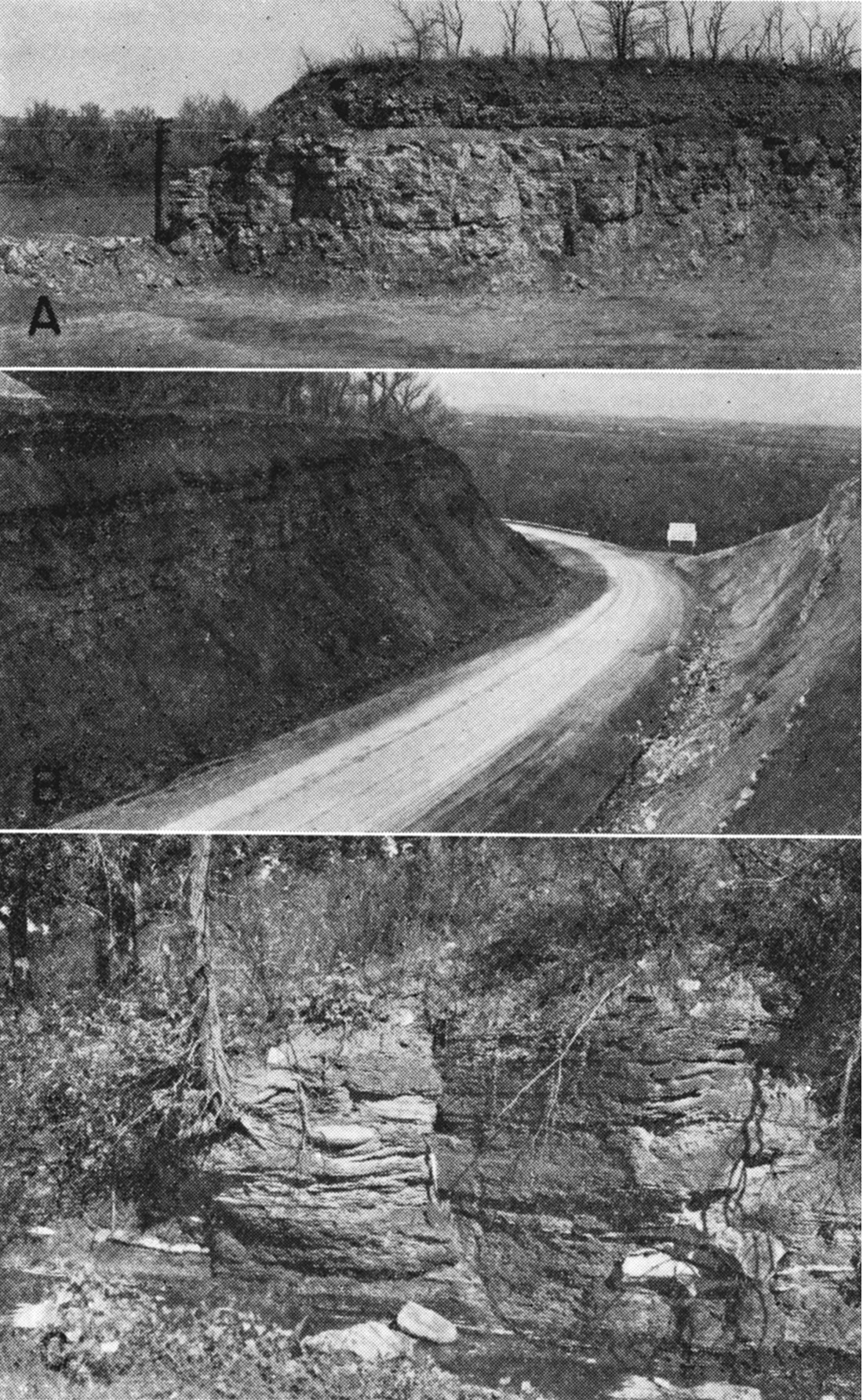
Plate 4—B, Massive Tonganoxie Sandstone member of Stranger Formation at Dightman's Crossing, Wakarusa River, NE NE sec. 14, T. 13 S., R. 20 E.
On fresh exposures the sandstone is very light gray to dark gray, the darker sand containing more carbonaceous material, the lighter sand being better sorted and cleaner. Small amounts of disseminated pyrite and iron-bearing clay minerals cause the sandstone to become stained with iron and to weather to tan or yellow brown on outcrops. The siltstone and shale beds of the Tonganoxie Sandstone member are gray to blue and weather tan to yellow brown. Ironstone and limonite concretions occur both in zones and scattered through the shaly parts of the member. Where the Westphalia Limestone member can not be recognized, the top of the Tonganoxie Sandstone member is placed at the top of the Upper Sibley coal. The thickness of the Tonganoxie ranges from 0 to about 120 feet.
Westphalia Limestone member--The Westphalia Limestone member is a medium-gray, carbonaceous laminated limestone as much as 1.5 feet thick, but it is not continuous and hence is not present at some of the outcrops of the section of rocks in which it normally occurs. A zone of calcareous shale above the Upper Sibley coal marks its probable position where limestone is not present, however. In addition to the carbonized plant fragments found in the bedding planes, it also contains the ostracode Jonesina howardensis and tiny gastropods. Its position directly over the Upper Sibley coal, its faunal assemblage, and its laminated appearance make this limestone unlike other underlying and overlying limestones and very easy to identify. The bed can be observed at several localities in the drainage area of Coal Creek and is well exposed in a road cut in the NW NE sec. 13, T. 14 S., R. 20 E.
Vinland Shale member--Gray clayey to sandy shale and sandstone beds. chiefly marine, ranging from about 6 to 25 feet in thickness, compose the Vinland Shale member. A zone of the pelecypod Myalina persists nearly everywhere in the shale and sandstone at the top of the member. Beds of sandstone in the upper part locally attain a thickness of about 12 feet. The sand is fine to very fine, slightly micaceous, and on outcrops is commonly well cemented with calcite. Beds of calcite-cemented sandstone directly underlying the Haskell Limestone member are exposed in road and creek cuts near the center of the S2 sec. 8, T. 14 S., R. 20 E. At a small quarry along the east side of a creek in the NW NE sec. 4, T. 15 S., R. 21 E., the equivalent beds are 10 to 15 feet of thin, irregular beds of silty and sandy limestone interbedded with limy sandstone, all of which contain a molluscan fauna. In sec. 34 and 35, T. 14 S., R. 20 E., the Vinland Shale member contains a zone of red and green shale together with a thin coal above the sandstone in the upper part of the member. Most outcrops of the Vinland are gray, tan-weathering, silty to sandy shale. Septarian concretions occur locally in the upper part.
Haskell Limestone member--Overlying the Vinland Shale member is the gray to bluish-gray, fine-grained Haskell Limestone member, which weathers brownish gray. The lower part of the Haskell Limestone member may be silty or very sandy locally where it overlies and is gradational into beds of sandstone in the Vinland Shale member. The lower, sandy part contains abundant mollusks. Fusulinids, brachiopods, crinoids, and calcareous "Cryptozoon"-type algae are common in the upper and middle parts, and locally the upper part is oolitic. The upper surface has numerous depressions containing small phosphatic nodules. The nodules contain a fauna (Twenhofel and Dunbar, 1914) including ganoid fish skulls and brain casts, nautiloids, ammonites, and orbiculoid brachiopods. Miller and Swineford (1957) discussed the paleoecology of the nodulose zone and concluded that the nodules are genetically related to and should be included with the Haskell Limestone rather than the Robbins Shale member.
The Haskell Limestone member is well exposed in and east of the City of Lawrence between Kansas and Wakarusa Rivers, and in the Coal Creek drainage area. It is the most widespread and distinctive marker bed between the Oread and Stanton Limestones in both the subsurface and outcrop areas of the Douglas and Pedee Groups. Its thickness ranges from about 1.3 to 5 feet. In the southern part of Douglas County post-Robbins pre-Ireland erosion locally removed the Haskell Limestone member and older beds.
Robbins Shale member--The Robbins Shale member is a gray marine clayey shale 50 to 100 feet thick in the vicinity of its type locality near Yates Center in Woodson County. In southern Douglas County the Robbins Shale member ranges in thickness from 0 to about 12 feet and is directly overlain by massive beds of the Ireland Sandstone member, which are believed to be of non-marine origin. In the northern two-thirds of the county, the Ireland Sandstone member is not recognized and the sequence from the base of the Oread Limestone to the top of the Haskell Limestone member is chiefly silty and sandy shale. Earlier workers (Patterson, 1933; Moore, 1936, 1949; Lins, 1950; Reynolds, 1957) studying these beds in the vicinity of Lawrence concluded that nearly all the clastic beds between the Oread Limestone and the Haskell Limestone member, except for a few inches of shale directly overlying the Haskell Limestone member, should arbitrarily be included in the Lawrence Shale. This provides a practical solution for mapping also, as the top of the Haskell and the base of the Oread are contacts that can be readily mapped in the field. The top of the Haskell Limestone was mapped throughout Douglas County as the boundary between the Lawrence Shale and the Stranger Formation, and the thin Robbins Shale member in the Baldwin area has been mapped with the Lawrence, Shale. Where pre-Ireland erosion removed the Haskell Limestone the base of the Ireland Sandstone is mapped as the formation boundary.
It is to be noted that Patterson (1933) collected several species of foraminifers, chiefly arenaceous types, ostracodes, and holothurian plates and spicules from the "lower Lawrence" shale beds above the Haskell Limestone member. Detailed stratigraphic and paleontologic studies of the Lawrence-Robbins shale section may reveal the presence of a considerable thickness of the marine or brackish-water Robbins Shale.
The Robbins Shale member exposed in the Baldwin area is a marine gray to blue argillaceous very thin bedded shale that weathers yellow tan. A few inches above the base is an impure goethite bed about 2 or 3 inches thick containing a molluscan fauna. Sparse marine fossils also occur in the lower part of the shale. Miller and Swineford (1957) described in detail the lower part of the Robbins Shale.
Lawrence Shale
The Lawrence Shale includes strata between the Robbins Shale member and the Oread Limestone in the southern third of Douglas County, but in the northern two-thirds, because the contact between the Robbins Shale and Lawrence Shale is indeterminate, all deposits between the Oread Limestone and the Haskell Limestone arbitrarily have been included with the Lawrence Shale. The top of the Haskell Limestone is mapped on Plate 1 as the base of the Lawrence Shale, except where pre-Ireland erosion has cut through the Haskell, in which case the disconformity is mapped as the base of the Lawrence Shale. In areas south of the Worden fault in southern Douglas County where the Toronto Limestone member of the Oread Limestone is missing, the base of the Leavenworth Limestone is mapped as the upper boundary of the Lawrence Shale.
The Lawrence Shale contains two named members, the Ireland Sandstone and the Amazonia Limestone, and two unnamed shales. The formation commonly is 140 to 170 feet thick but locally in the area south of the Worden fault it is only 60 feet thick.
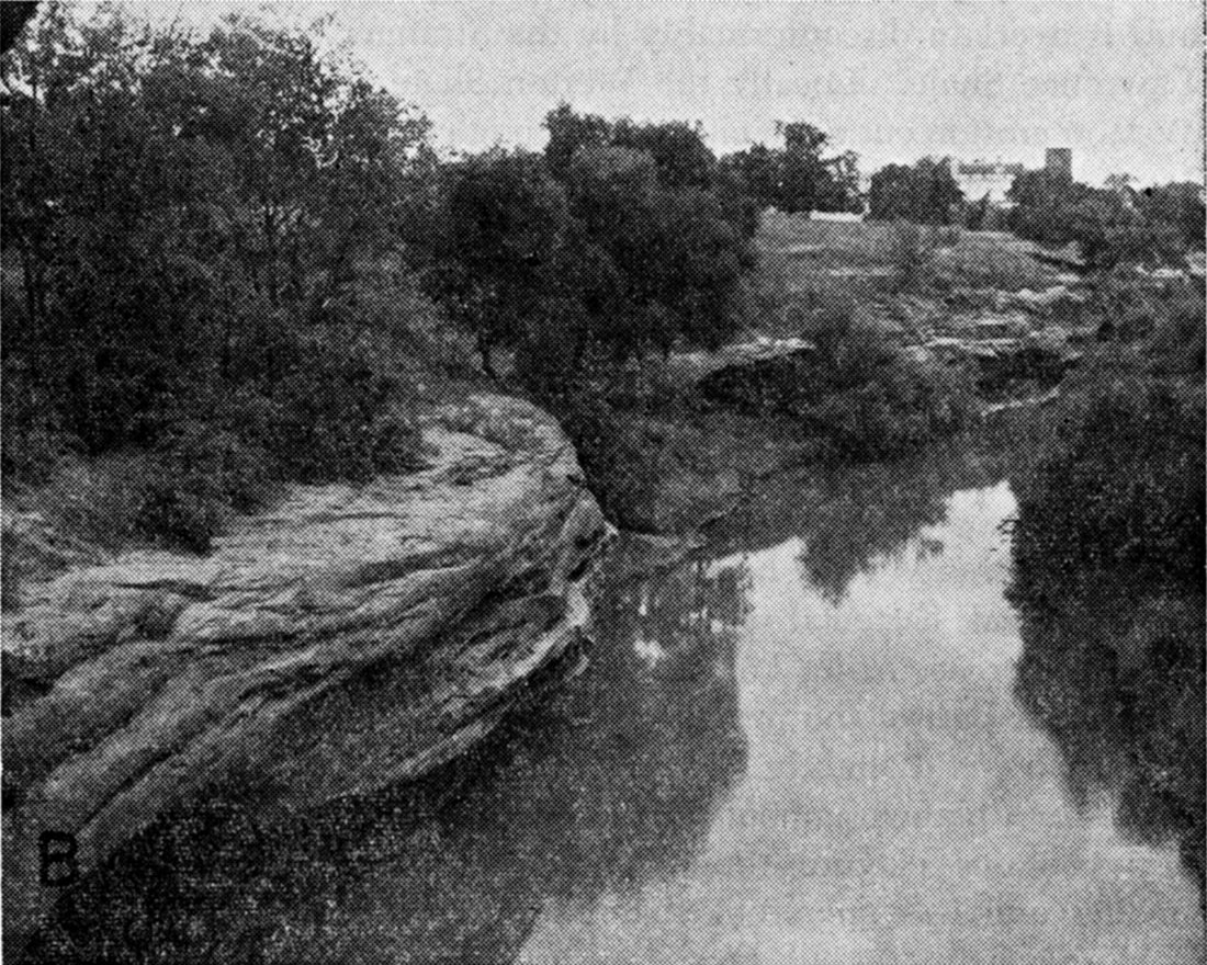
Ireland Sandstone member--The name Ireland Sandstone member is applied to one or more beds of sandstone in the lower part of the Lawrence Shale below the Amazonia(?) Limestone. The sandstone is similar in lithology, color, composition, and texture to the Tonganoxie Sandstone except that it may be slightly coarser. In the subsurface the Ireland Sandstone is light gray where clean and well sorted, and medium or dark gray where carbonaceous material is more abundant. The direction of streamflow during deposition of the Ireland Sandstone member is indicated by the direction of inclination of foreset beds in some outcrops (Pl. 5A). The Ireland Sandstone is chiefly very fine to medium (1/16 to 1/2 mm), angular to subangular quartz containing a small percentage of mica, pyrite, and clay minerals and weathers tan or yellow brown. Thin-bedded and shaly parts of the Ireland may contain more clay and silt than sand.
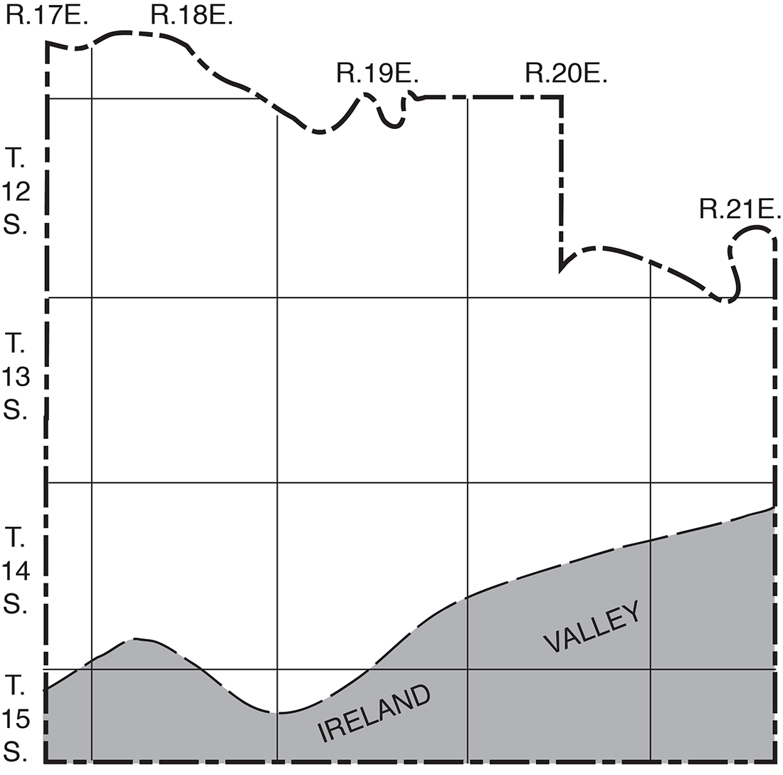
The Ireland Sandstone, ranging in thickness from 0 to about 150 feet, fills a west-southwest-trending erosional valley cut into the Stranger Formation and Weston Shale in southern Douglas County (Fig. 5).
Plate 5—A, Westward-dipping foreset beds of thick Ireland Sandstone member of Lawrence Shale at "Hole in the Rock", NE NW sec. 2, T. 15 S., R. 19 E.; B, Detrital Amazonia (?) Limestone member in upper part of Lawrence Shale, center S2 SE sec. 2, T. 14 S., R. 18 E.
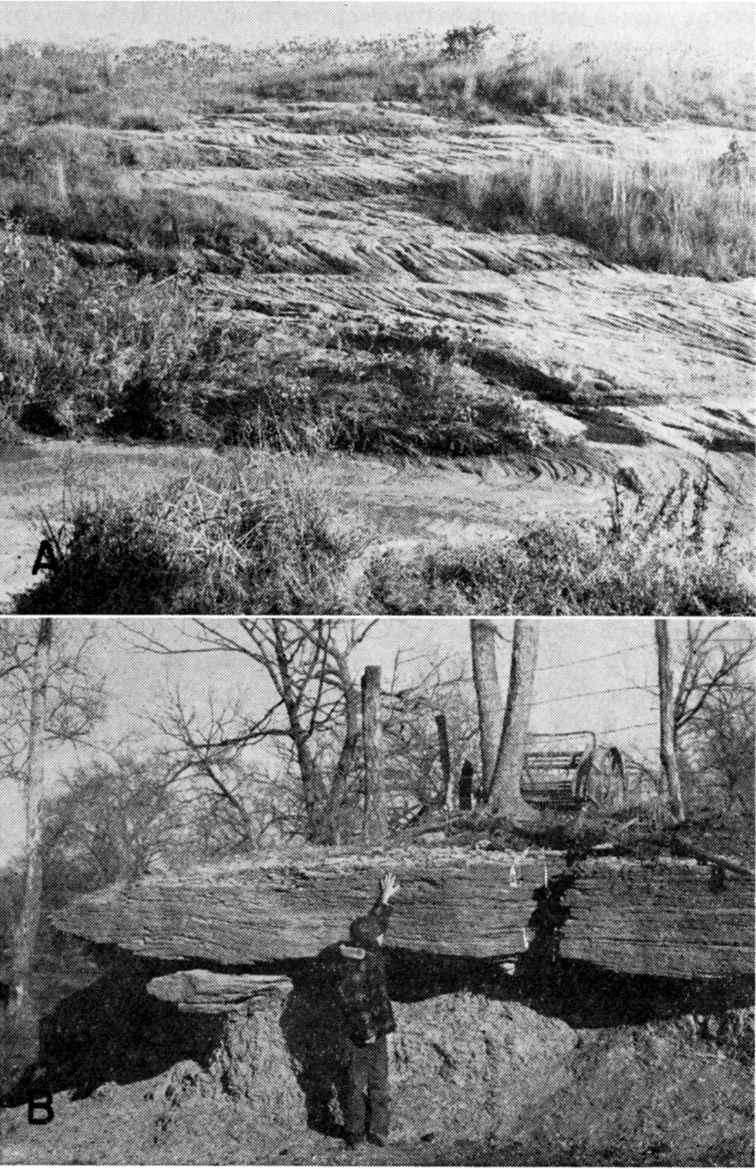
Figure 5.--Generalized map of Douglas County showing location of ancient valley in which Ireland Sandstone member of Lawrence Shale was deposited.
In the headwaters area of Captain Creek the relation of the Ireland Sandstone to the topography over which the sandstone was deposited can be clearly observed. In sec. 21 and 22, T. 14 S., R. 21 E., a deep channel filled with massive crossbedded sandstone and conglomerate trends nearly west along the northern part of each section. The base of the sandstone rises southward and is about 100 feet higher in the southwest corner of sec. 22 (Pl. 3, F-F'). Exposures along Captain Creek near the north side of sec. 21, T. 14 S., R. 21 E., show conglomerate at the base of the Ireland Sandstone in contact with the Weston Shale.
The Ireland Sandstone member was deposited in an ancient erosional valley about half a mile wide cut to a depth of about 100 feet below the Haskell Limestone in southeastern and south-central Douglas County. In an area 5 to 15 miles wide adjacent to the major channel, post-Stranger pre-Ireland erosion cut less deeply into the Stranger Formation and Weston Shale. In this wide area basal deposits of the Ireland Sandstone lie at various positions ranging from 50 feet or more below to about 12 feet above the Haskell, and in most of this area the sandstone adjacent to the principal sandstone-filled area shown in Figure 5 is about 40 feet thick. The Ireland Sandstone thins and becomes shaly in the central and northern parts of Douglas County and can not be differentiated.
Test hole 15-21-4bcc was drilled through 115 feet of Ireland Sandstone having an exceptionally thick conglomerate-nearly 46 feet-in the lower part. The base of the Ireland member is less than 30 feet above the Stanton Limestone, erosion having cut out all the Stranger Formation and most of the Weston Shale. Abundant fragments of detrital coal in the conglomerate and lower part of the sandstone must have been derived from coal beds in the Stranger Formation exposed locally as a result of post-Stranger pre-Ireland and early Ireland erosion. Rich (1932a, 1933) reported the occurrence of abundant coal fragments in the lower part of the Ireland Sandstone in Franklin County and suggested a similar source.
Amazonia(?) Limestone member--The Amazonia(?) Limestone member is doubtfully recognized throughout most of the outcrop area. A few drillers logs indicate a thin limestone in the Upper part of the Lawrence Shale, which may be the Amazonia(?) member. Locally the member may be present as an impure silty limestone or as detrital limestone. Such a detrital limestone, about 4 feet thick and containing considerable coal and shale fragments and having the appearance of a local channel filling, is well exposed near the center of the S2 SE sec. 2, T. 14 S., R. 18 E. (Pl. 5B). A similar detrital limestone is present farther north in parts of adjacent Leavenworth County (Reynolds, 1957).
Where a limestone bed is not recognized the member may be represented by a zone of caliche-like nodules of limestone about 20 to 45 feet below the top of the Lawrence Shale. Thickness of the member ranges from somewhat less than 1 foot to about 6 feet. Fragments of crinoids and brachiopods, small gastropods, and pelecypods are the common fossils.
Unnamed members--Between the Ireland Sandstone and Amazonia(?) Limestone members there commonly is 5 to 20 feet of sandy and silty gray shale containing the Lower Williamsburg coal. That part of the formation between the Toronto and Amazonia(?) limestone members is chiefly shale and ranges from about 20 to 40 feet in thickness. It contains the thin Upper Williamsburg coal, best developed in the southern half of the county. This upper shale is olive, gray, and greenish gray and in many outcrops has a red or maroon zone, about 2 feet thick, 10 to 25 feet below the top. A bed of very fine grained sandstone several feet thick, partly cemented with calcite, or interbedded sandstone and siltstone occurs locally in the lower part and makes a subdued topographic bench on hillsides. The Upper Williamsburg coal, 0.5 to 1 foot thick, is present about 10 feet below the Toronto Limestone in the vicinity of Lone Star Lake.
Shawnee Group
Oread Limestone
The Oread Limestone is the lowest of the scarp-forming limestones of the Shawnee Group. Its average thickness, where all four limestone and three shale members are present, is about 60 feet. In part of southern Douglas County the Toronto Limestone member is absent, the beds between the base of the Lawrence Shale and the base of the Leavenworth Limestone are termed the Lawrence-Snyderville Shale, and the base of the Leavenworth Limestone member is mapped as the base of the Oread Limestone.
Toronto Limestone member--The Toronto Limestone member typically is light yellow brown or light gray when fresh but on exposure becomes a deep yellow brown. Its average thickness is about 10 feet. The rock appears massive on fresh exposures, but breaks into slabby and irregular fragments upon weathering. Generally there are at least two thin partings consisting of shale or shaly limestone in the bed. Parts of the member contain abundant fossils, which weather white. Fusulinids and crinoid fragments are common, and bryozoans, born corals, brachiopods, mollusks, and algae are locally abundant. Scattered chert nodules, weathering yellow brown, are common in the upper part in many outcrops.
Exposures of the Toronto Limestone in the area north of Baldwin, chiefly in T. 14 S., R. 20 E., are atypical and include light-gray-weathering, conglomeratic or brecciated semilithographic or thin-bedded argillaceous limestone in the lower part or locally throughout the member (Pl. 6B). Typical yellow-brown-weathering Toronto locally may be slightly sandy, whereas the light-gray semilithographic limestone appears pure but contains areas of light-greenish-gray clay and scattered pyrite nodules 1/2 to 1 inch in diameter.
Plate 6—A, Plattsmouth Limestone, Heumader Shale, and Kereford Limestone members of Oread Limestone in quarry along Kansas river at east edge of Lecompton, NW SW sec. 35, T. 11 S., R. 18 E.; B, Lower and middle Oread Limestone showing unusually thin Snyderville Shale member and brecciated thin- to medium-bedded Toronto Limestone member below normal Heebner Shale and Leavenworth Limestone members. View north from SW NW sec. 21, T. 14 S., R. 20 E., Blue and Bald Mounds on horizon; C, Thick black fissile Heebner Shale member south of Worden fault, NW NW sec. 8, T. 15 S., R. 19 E. Note large calcareous concretions, which occur only in the abnormally thick black Heebner Shale. Compare with black Heebner Shale in 6B.
In parts of T. 14 and 15 S., R. 20 E., the Toronto Limestone member grades from typical Toronto to brecciated and conglomeratic limestone. The Toronto Limestone member is absent as a result of nondeposition or post-depositional erosion in parts of southern Douglas County.
Snyderville Shale member--The shale beds overlying the Toronto Limestone member are chiefly green and gray argillaceous and silty shale, claystone, and siltstone. Although the thickness of the shale averages about 10 or 15 feet, it ranges from about 0.1 foot to 45 feet. The lower and middle parts are chiefly a structureless claystone or siltstone, which weathers into blocky irregular fragments and has the appearance of an old soil or underclay. In a small quarry in the SE SW sec. 20, T. 14 S., R. 20 E., this "soil" of the Snyderville seems to be particularly well developed, extending deep into the underlying Toronto. The Toronto seems to be partly reached and "rotted".
Above the structureless claystone or siltstone, in the top 2 or 3 feet of the member, locally a thin carbonaceous streak is overlain by gray calcareous and fossiliferous marine shale.
In the outlier of Oread Limestone at the northeast edge of Baldwin (sec. 34 and 35, T. 14 S., R. 20 E.) the Snyderville, about 45 feet thick, contains at its base nearly 10 feet of limestone conglomerate derived from the reworked Toronto Limestone member. In a new road cut in the SW NW sec. 27, T. 14 S., R. 20 E., the Snyderville is only about 1 foot thick (Pl. 6B).
To the west of Baldwin, south of the Worden fault, the base of the Snyderville cannot readily be identified, but the upper part of the Lawrence-Snyderville deposits is silty and sandy, contains 2 or 3 thin coal seams, and locally several thin molluscan limestones, which may be an expanded equivalent of the marine upper 2 or 3 feet of the Snyderville in the area north of the fault. At several exposures in the Worden area Lawrence-Snyderville beds show evidence of penecontemporaneous slumping and sliding.
Leavenworth Limestone member--The Leavenworth Limestone member ranges in thickness from 0.8 foot to 2 feet except along and south of the Worden fault, where locally it is as much as 3.4 feet thick. It is composed of a single massive bed of hard gray-blue fine-grained limestone, which weathers light gray or creamy tan (Pl. 6B). It is brittle and breaks along closely spaced, nearly vertical joints, forming fragments having sharp edges. Many outcrops show a highly developed system of incipient vertical fractures, which cause the bed to break into sharp-edged angular fragments where it is exposed to active mechanical weathering processes.
Fossils are most abundant in the upper and lower parts and include fusulinids, crinoid and brachiopod fragments, and small cryptozoon-type algae. Small mollusks are generally abundant in the lower and upper 0.2 foot of the bed. The lower molluscan part locally weathers shaly and rusty brown.
Heebner Shale member--The Heebner Shale is composed of about 5 to 8 feet of shale in central and northern Douglas County. The upper part is thin-bedded gray to olive shale generally containing few or no megafossils, although sparse brachiopods are present locally. The lower part consists of hard black, carbonaceous fissile shale containing conodonts and small elliptical gray-brown phosphatic concretions. The average thickness of the black fissile shale is 3 to 4 feet. In a few exposures the black shale does not lie directly on the Leavenworth Limestone but is separated from it by a few tenths of a foot of thin-bedded gray to olive shale.
In parts of south-central Douglas County south of the Worden fault the Heebner Shale is unusually thick, being about 14 to 18 feet. The sequence of lithologies is typical, except that large elliptical and elongate dense gray carbonaceous and pyritic limestone concretions are common in the black fissile shale (Pl. 6C), which may be as much as 12 feet thick compared with the average 3 or 4 feet elsewhere.
Plattsmouth Limestone member--The Plattsmouth Limestone member, about 18 feet thick (Pl. 6A), is composed almost entirely of light-gray to nearly white wavy-bedded limestone, which weathers light gray to light tan. Scattered blue-gray chert nodules occur persistently near the middle of the bed. Thin gray shale partings between the wavy beds of limestone range in thickness from a featheredge to about 0.5 foot, but the aggregate thickness of shale beds in the member is small. The limestone, the chert, and the shale partings are fossiliferous; the fossils include fusulinids, crinoids, brachiopods, mollusks, corals, and algae. In many fossils the contained calcite is much more coarsely crystalline than that of the limestone matrix.
At several localities sinkholes have developed in and through the Plattsmouth Limestone member. These are associated with drainage changes (E2 sec. 15, T. 13 S., R. 18 E.) or with faulting or deformation of the beds (sec. 32, 33, and 36, T. 14 S., R. 19 E., and E2 sec. 12, T. 15 S., R. 18 E.).
Heumader Shale member--In most outcrops, the Heumader Shale member is 2 to 4 feet thick (Pl. 6A), but locally it is slightly thicker. It is chiefly gray to green clayey and calcareous shale. Some exposures contain abundant fossils, chiefly brachiopods and mollusks, whereas others are seemingly unfossiliferous.
Kereford Limestone member--The top member of the Oread Limestone consists of 2.5 to 9 feet of gray limestone and calcareous shale beds, which weather light gray to tan. In most exposures limestone composes two-thirds or more of the member, but calcareous shale beds may constitute half or slightly more of the deposits locally. Both limestone and shale beds contain abundant fossils, including fusulinids, brachiopods, born corals, bryozoans, mollusks, crinoids, and algae. The lower limestone beds tend to be flags , and the upper limestone beds locally are oölitic.
Because the Kereford is relatively thin and nonresistant to weathering and is but a few feet above the escarpment-making Plattsmouth Limestone, natural exposures are not common. The Kereford is well exposed, however, in several quarries in the Plattsmouth Limestone.
Kanwaka Shale
Thickness of the Kanwaka Shale ranges from 56 to 87 feet but averages about 60 feet. The formation includes one limestone and two shale members.
Jackson Park Shale member--The basal member of the Kanwaka consists of blue to gray silty to sandy micaceous shale, 33 to 52 feet thick, that weathers tan. Carbonized plant remains occur in the shale, and locally it contains a very thin coaly streak in the upper part. The member becomes more sandy toward the southwest and in places includes beds of very fine-grained sandstone in the lower part.
Clay Creek Limestone member--The Clay Creek Limestone member is blue-gray, fine-grained to granular limestone, 3 to 6 feet thick, that weathers brownish gray. The lower and middle parts of the member are massive, vertically jointed limestone in fresh exposures but shelly where weathered, This part contains abundant fusulinids, brachiopods, and crinoid fragments.
The upper part consists of fossiliferous gray shale, as much as 1.2 feet thick, overlain by gray algal and molluscan fragmental limestone a few tenths of a foot thick.
Stull Shale member--The Stull Shale member ranges from about 18 to 28 feet in thickness and comprises blue-gray clayey, silty, and sandy micaceous shale and gray very fine grained micaceous sandstone. Both shale and sandstone weather buff to tan. Sandstone in the middle and upper part of the member is as much as 11 feet thick in the north, but is much thinner or absent in the central and southern parts of the county. Carbonized plant remains are common in the shale beds and, locally, one or more very thin coals are present. The upper part of the member contains a sparse molluscan fauna in the Twin Mounds area, south of Wakarusa River.
Lecompton Limestone
The thickness of the Lecompton Limestone ranges from about 40 to 57 feet. The four limestone and three shale members that compose the formation closely resemble, in sequence and lithology, the members of the Oread Limestone.
Spring Branch Limestone member--The Spring Branch Limestone member is the basal member of the Lecompton Limestone and is 8 to 14 feet thick. The lowest 5 feet is massive light-tan or light-gray-brown limestone in its unweathered state, but deep yellow brown where weathered, similar to the Toronto Limestone member of the Oread Limestone. This basal 5 feet is more resistant to weathering than the upper part and forms a prominent bench on hillsides. The massive bed contains chiefly crinoid and brachiopod remains in the lower 2 or 3 feet and a profusion of fusulinids in the upper part.
Overlying the resistant bench are beds of shaly limestone, shale, and limestone generally 3 to 8 feet thick. Fusulinids are plentiful in the lower 1 to 3 feet of these shaly beds. Interbedded unfossiliferous or sparsely fossiliferous beds of gray to tan shale and lime-stone overlain by a thin gray semilithographic, algal, or conglomeratic limestone constitute the upper part of the member.
Excellent exposures of the Spring Branch and other members of the Lecompton Limestone can be observed along the Kansas Turnpike in sec. 24, T. 12 S., R. 18 E., and in road and railroad cuts in the NW sec. 36, T. 11 S., R. 17 E., just west of Grove.
Doniphan Shale member--Dark-gray, weathering tan to brown, clayey shale 2 to 5 feet thick composes the Doniphan Shale member. Carbonized plant remains are present in the lower and middle parts and sparse mollusks in the upper part. The beds of the middle part locally contain a thin coal smut. The shale is partly thin bedded to subfissile, partly poorly bedded clay, which weathers blocky.
Big Springs Limestone member--The Big Springs Limestone member is a dark, blue-gray dense to fine-grained limestone 2 to 3 feet thick, comparable to the Leavenworth and Rock Bluff Limestone members of other Shawnee formations. It weathers light tan, has prominent vertical joints, and locally may contain a thin shale break in the lower middle part. Fusulinids are abundant, especially in the lower part, but calcareous algae of the Cryptozoon and Osagia types, crinoids, bryozoans, brachiopods, and small mollusks also occur in the member.
Queen Hill Shale member--The Queen Hill Shale member is 2 to 5 feet thick. The lower part is hard black fissile and subfissile shale, which is nonfossiliferous except for finely divided carbonaceous plant material and conodonts. The upper part is gray, tan-weathering, thin-bedded shale.
Beil Limestone member--The Beil Limestone member is 9 to 10 feet thick. The lower half consists of relatively massive, somewhat irregularly bedded light-gray fossiliferous limestone. Thin irregular, featheredge shale partings also are included in this part of the member. The upper beds consist of interbedded thin nodular limestone, shaly limestone, and very calcareous shale. The entire member is abundantly fossiliferous, and the fossils weather free from the enclosing shaly matrix of the upper beds. Fusulinids, the corals Caninia and Syringopora, several species of brachiopods and bryozoans, crinoid fragments, and bellerophontid gastropods characterize the fauna. Weathered outcrops of the Beil Limestone are light gray, tan, and buff.
King Hill Shale member--The King Hill Shale member averages 8 or 9 feet in thickness but locally may be as thin as 5 feet. It is chiefly gray, green, and yellow clayey and calcareous shale containing a persistent yellow impure "boxwork" limestone in the upper part and generally one or more thin impure limestones in the middle and lower parts. Sparse mollusks and brachiopods may occur in the top foot of the shale, but the member is almost devoid of megafossils.
Avoca Limestone member--The uppermost member of the Lecompton Limestone is the Avoca Limestone member, which ranges in thickness from 3 to 4.5 feet. It is chiefly a dense, gray-blue massive limestone, which weathers blue gray to buff. The lower and middle part, a single massive bed, contains abundant fusulinids. Overlying this massive bed, in several exposures, is 0.1 to 0.5 foot of gray shale capped by a thin shaly, coquinoid, or algal limestone.
A fairly common feature of the upper part of the Avoca is the dark-gray somewhat fan-shaped areas containing irregular :fine concentric markings, which are thought to be burrows of a worm. These worm markings are well exposed and abundant in the Avoca outcrop in the bed of Spring Creek near the center of the SE SE sec. 2, T. 12 S., R. 17 E.
Tecumseh Shale
Along Kansas River the Tecumseh Shale is about 65 feet thick but thins southward to about 58 feet. The lower 35 to 45 feet is chiefly gray micaceous sandy and silty shale and siltstone, which in several exposures consist of alternating light and dark varve-like laminae ranging in thickness from about 1 to 100 mm. The dark units are thinner and much more carbonaceous than the lighter colored units. Next higher is a very fine grained gray quartzose sandstone ranging in thickness from 0 to about 10 feet. Where sandstone is absent the upper beds are gray to olive sandy and silty shale. Although plant fossils are common in much of the member, marine fossils are found only in the upper few feet of shale and are rare or absent in most exposures. Locally, about 10 feet from the top of the formation the shale contains a few limy nodules or a thin irregular limestone. Weathered exposures of beds in the Tecumseh Shale range from light yellow gray to tan.
Deer Creek Limestone
The Deer Creek Limestone is divided into three limestone and two shale members having an aggregate thickness of about 34 feet. Generally the formation is slightly thinner in outcrops in Douglas County than in adjacent Osage, Shawnee, and Jefferson Counties.
Ozawkie Limestone member--The basal member of the Deer Creek Limestone directly overlies the thick Tecumseh Shale and ranges from about 5 to 11 feet in thickness. The lower part typically is a massive, gray, brown-weathering limestone containing abundant fusulinids and Osagia. Upper beds are massive light-gray to buff earthy, impure molluscan limestone, which weathers to various shades of yellow or brown. Although the limestone is massive, it commonly weathers into irregular shelly chips. Locally, as along the Kansas Turnpike in the NW sec. 22, T. 12 S., R. 18 E., the upper and lower beds are shaly unfossiliferous limestone and the middle beds are chiefly massive light-gray oolitic limestone.
Oskaloosa Shale member--The thin Oskaloosa Shale member overlies the Ozawkie Limestone member and ranges from about 3 to 5 feet in thickness in outcrops. The member is thin-bedded shale and blocky clay. It is gray to greenish on fresh exposures but drab yellow when weathered. Fossils are rare or absent in most exposures.
Rock Bluff Limestone member--The Rock Bluff Limestone member in the Deer Creek megacyclothem is analogous to the Big Springs and Leavenworth Limestone members of the Lecompton and Oread megacyclothems, respectively, and is a persistent and distinctive part of the formation. It is a single bed of hard, dense to fine-grained dark-blue-gray limestone, which is about 2 feet thick and has prominent vertical joints. It weathers light gray tan to gray brown. Fusulinids, brachiopods, crinoid fragments, and small mollusks are the common fossils found in it.
Larsh-Burroak Shale member--Black, slaty, and fissile shale about 0.5 foot to 2.0 feet thick forms the basal part of the Larsh-Burroak Shale except in some places where it is separated from the underlying Rock Bluff Limestone by 0.1 foot or less of brown clayey shale. The upper beds are dark- to light-gray thin-bedded shale. Recognizable fossils are scarce but there are conodonts and fish remains in the black shale, and sparse specimens of the brachiopods Crurithyris and Orbiculoidea may be found in the dark-gray shale.
The Larsh-Burroak member ranges from about 2.5 to 5.0 feet in thickness and commonly is about 3 feet thick.
Ervine Creek Limestone member--The Ervine Creek Limestone member ranges from about 13 to 17 feet and averages about 15 feet in thickness. The basal part, about 10 to 14 feet thick, is light-gray to white hard thin, wavy-bedded limestone containing several thin gray shale partings. The limestone is dense to finely crystalline, but contains irregularly distributed veinlets and fossil replacements of coarsely crystalline clear calcite. Fusulinids, brachiopods, crinoids, and echinoid and bryozoan fragments are common, and mollusks, corals, and sponges also may be found in the bed. Sparse chert nodules occur near the middle.
A thin, medium- to dark-gray shale about 1 foot thick overlies the wavy-bedded limestone locally and is overlain by about 3 feet of gray argillaccous and coquinoid limestone containing a molluscan fauna and the brachiopods Derbyia and Linoproductus. These upper few feet of shale and limestone tend to weather more rapidly and are not well exposed in most natural outcrops.
Calhoun Shale
In the vicinity of Big Springs the Calhoun Shale is about 60 to 68 feet thick. It is chiefly silty and sandy partly laminated carbonaceous gray shale containing a very thin carbonaceous bed or coal bed 1 to 2 feet from the top. An intraformational channel sandstone trending south and west through the town of Big Springs is well exposed in cuts on U. S. Highway 40 in the SW sec. 11, T. 12 S., R. 17 E. About 30 feet of gray fine to very fine grained (1/4 to 1/16 mm) crossbedded micaceous, quartzose sandstone can be observed in the upper and middle parts of the formation in cuts along Kansas Turnpike in the SE1/4 sec. 11, T. 12 S., R. 17 E. Both the shale and the sandstone contain plant remains, and a few pelecypods were found at the top of the formation. The shale and sandstone weather yellow brown to tan.
Topeka Limestone
The Topeka Limestone is the youngest Pennsylvanian formation exposed in Douglas County and it is exposed only in the vicinity of Big Springs. Only the lower part of the formation is present in Douglas County.
Hartford Limestone member--The Hartford Limestone member is 6 to 8 feet thick and consists of two limestone beds separated by a thin shale bed just below the middle of the member.
The limestones are light gray but readily weather to a deep yellow brown. The lower part is abundantly fossiliferous, containing fusulinids, crinoids, bryozoans, brachiopods, Cryptozoon, and gastropods. The upper part contains chiefly large gastropods, productid brachiopods, the brachiopod Derbyia, and algae. The upper part locally has a semioölitic texture, and the top surface may be very uneven. The thin middle shaly part is limy and fossiliferous.
Iowa Point Shale member--Gray, tan-weathering thin-bedded calcareous shale averaging 2 to 3 feet in thickness is correlated with the Iowa Point Shale. Although not as fossiliferous as adjacent limestone beds, it commonly contains fusulinids, brachiopods, and bryozoans.
Curzon Limestone member--Interbedded massive to thin-bedded limestone and thin-bedded calcareous shale having a thickness of about 12 feet compose the Curzon Limestone member. The limestone and shale beds are light to medium gray in unweathered exposures, but where weathered are yellow brown. Fossils are abundant and include crinoids, echinoids, born corals, fusulinids, and several species of brachiopods and bryozoans.
Jones Point Shale member--The youngest beds of the Topeka Limestone exposed are beds of gray shale that overlie the Curzon Limestone member and probably represent part of the Jones Point Shale member. The exposed thickness of this member is about 1 foot.
Prev Page--Lansing and Pedee Groups || Next Page--Quaternary rocks
Kansas Geological Survey, Geohydrology of Douglas County
Web version Aug. 1999. Original publication date Dec. 1960.
Comments to webadmin@kgs.ku.edu
The URL for this page is http://www.kgs.ku.edu/General/Geology/Douglas/strat04.html