![]()
Prev Page--Chemical Character || Next Page--Well Records
Geologic Formations and their Water-bearing Properties
Cretaceous System
Gulfian Series
Pierre Shale
The oldest formation that crops out in Cheyenne County is the Pierre shale of late Cretaceous (Gulfian) age. The Pierre shale in northwestern Kansas has been studied and described by Elias (1931). He separated the Pierre into six members; only two, the Beecher Island shale member and an unnamed and unstudied shale member, are thought to crop out in Cheyenne County. The Pierre in Cheyenne County consists mainly of brown to yellow-brown shale. Dark-gray to black shale is not common in outcrops but was noted at several localities and was penetrated in several test holes. The shale contains many thin layers of gypsum and a few thin beds of brown limestone. The Pierre shale crops out at many localities in the north half of Cheyenne County, particularly along tributaries to Arikaree River and South Fork. The entire county is underlain by the Pierre, which ranges in thickness from about 900 feet in the southern part of the county to 1,100 feet in the north-central and northeastern parts and to 1,400 feet in the northwestern part. In an oil test well drilled in 1951 in the SE SE NW sec. 26, T. 1 S., R. 39 W., the Pierre had a thickness of about 1,050 feet.
The Pierre shale is of no consequence as an aquifer in Cheyenne County; however, the formation serves as an impervious floor below the water-bearing sediments, and retards or prevents the downward percolation of water in much the same manner as the floor of a tank; to a large extent the configuration of the Pierre shale determines the shape and slope of the water table. Contours showing the configuration of the surface of the Pierre shale are shown on Figure 7. No wells are known to derive water from the Pierre in Cheyenne County, but the quality of water in wells extended into the shale is affected by its contact with the shale. Typically, water in such wells contains more dissolved solids, is harder, has a larger percentage of permanent hardness, and is much higher in sulfate content than average (Table 3 and Fig. 10, wells 1-39-25bbc, 1-41-29dba, 3-40-21dcd, and others).
Tertiary System
Pliocene Series
Ogallala Formation
The Ogallala formation was named by Darton in 1899 (pp. 732, 734) for a locality in southwestern Nebraska. In 1920 Darton (p. 6) referred to the type locality as near Ogallala Station in southwestern Nebraska. Elias (1931) made an intensive study of the Ogallala formation in Wallace County and in 1937 he briefly described the formation with special reference to ground water in Rawlins County. Other studies of the Ogallala in northwestern Kansas have been made in Thomas County by Frye (1945) and in Norton and Phillips counties by Frye and Leonard (1949).
Character--The Ogallala formation in Cheyenne County consists chiefly of sand, gravel, and silt; beds of bentonitic clay, caliche and sandy limestone; and zones of opal and chert. In areas outside Cheyenne County the Ogallala contains also beds of volcanic ash, diatomaceous marl, and "quartzite." The character of the Ogallala is given by the logs of test holes at the end of the report and in the following measured section.
| Section measured in a road cut in the NE sec. 19, T. 3 S., R. 40 W., Cheyenne County. Measured by A. I. Johnson and Mervin Klug. | Thickness, feet |
|||
|---|---|---|---|---|
| Tertiary--Pliocene | ||||
| Ogallala formation | ||||
| 5. | Mortar bed, gray-white to pinkish-white | 12.0 | ||
| 4. | Sand, fine to medium, silty, partially cemented, reddish-brown | 4.6 | ||
| 3. | Sand, very fine to medium, silty, light pinkish-gray; contains abundant Biorbia fossilia fruits | 7.4 | ||
| 2. | Clay, shaly, olive-green; contains many calcareous nodules | 10.5 | ||
| Cretaceous--Gulfian | ||||
| Pierre shale | ||||
| 1. | Shale, unctuous, fissile, black | 5.0 | ||
| Total measured | 39.5 | |||
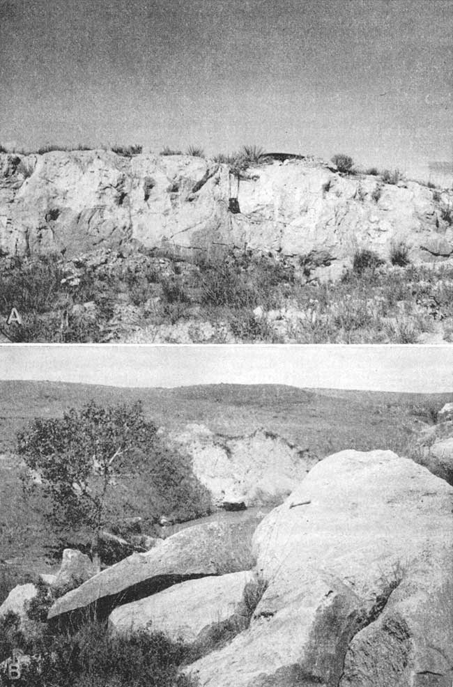
Sand is the most common constituent of the Ogallala formation and is found at nearly all stratigraphic positions; in some places the sand is in uniform well-sorted beds, but it generally is poorly sorted and mixed with silt, clay, or gravel. Gravel beds containing large amounts of sand and silt occur at many stratigraphic positions, but thick beds of uniform gravel are uncommon. Silt and clay, either mixed with deposits of sand and gravel or in layers, are common in the Ogallala. The silt layers may be reddish brown, tan, buff, gray, or white, generally contain nodules or stringers of caliche (calcium carbonate), and may be partially cemented with calcium carbonate. Many of the beds in the Ogallala are cemented or partially cemented, generally with calcium carbonate. Where sand and gravel deposits are cemented with calcium carbonate they may form rough benches or scarps and are called "mortar beds" because of the resemblance to old mortar. Plate 6A shows a type of mortar bed that crops out in several localities in Cheyenne County. The mortar bed is composed mainly of light-tan silt and fine sand, is well cemented, and is very hard. Plate 6B is a photograph of another type of mortar bed. It is less firmly cemented than that described above.
Plate 6--A, Very hard variety of mortar bed in Ogallala formation, SW sec. 21, T. 2 S., R. 39 W. B, Large broken and slumped blocks of mortar bed, NE sec. 4, T. 2 S., R. 38 W.
The Ogallala contains calcium carbonate, not only as cementing material and nodules, but also in beds or lenses (called "caliche"). The thickness of bedded caliche ranges from a few inches to 31 feet (test hole 1-37-34ccc).
Beds in the Ogallala are characteristic ally lenticular and discontinuous but the "Algal limestone," the uppermost bed, has been found in outcrops in Kansas from northwest Cheyenne County as far east as Lincoln County. This limestone has a peculiar concentrically banded structure and was thought by Elias (1931, pp. 136-141) to have been precipitated in quiet water at least in part by the alga Chlorellopsis. The "Algal limestone" has a maximum thickness of about 4 feet in Cheyenne County, is generally reddish, and weathers to a knobby, irregular surface. Outcrops of the "Algal limestone" are fairly common in Cheyenne County and have been found in several different localities--for example, in the SW sec. 22, T. 1 S., R. 42 W.; in the NW sec. 31, T. 5 S., R. 40 W., and in the SW sec. 27, T. 1 S., R. 37 W.
Distribution and thickness--The Ogallala underlies most of Cheyenne County except in areas along South Fork and its tributaries where it has been removed by erosion. Also, the formation is very thin or absent in much of T. 1 S., which borders Nebraska (Figs. 5, 6). The Ogallala is overlain in most of the county by Pleistocene deposits but it crops out along many of the streams in places where it has been exposed by stream or wind erosion (Pl. 1). The thickness of the Ogallala in test holes ranged from 289 feet in test hole 6-40-1aaa, drilled on the Sherman County border, to the vanishing point in several holes drilled along South Fork. The thickness of the formation is shown in the cross sections (Figs. 5 and 6) and in the logs of test holes given in this report.
Age and correlation--In 1899 Darton (pp. 732, 734) applied the name Ogallala formation to deposits formerly called "Tertiary grit" and considered of Miocene age by Hay (1895, p. 570). Darton considered these deposits to be of Pliocene age and the formation is now generally considered to be of Pliocene age, on the basis of paleontological evidence.
The State Geological Survey of Kansas recognizes three members in the Ogallala formation. These members, which range from early Pliocene (or possibly late Miocene) to late Pliocene, are: Valentine, Ash Hollow, and Kimball. Their recognition is based primarily on plant fossils and a few distinctive lithologic types. Elias (1942) considers Stipidium commune to be the most common grass seed in the Valentine member. Krynitzkia coroniformis is generally indicative of the lower Ash Hollow or upper Valentine, and Biorbia fossilia is characteristic of the remainder of the Ash Hollow. Prolithospernum johnstoni is the most diagnostic form in the Kimball member and the "Algal limestone" at the top of this member simplifies its identification.
The Kimball member of the Ogallala has been identified in several areas in Cheyenne County by outcrops of the "Algal limestone." The abundance of Biorbia fossilia in beds in the NE sec. 19, T. 3 S., R. 40 W., the NW sec. 9, T. 4 S., R. 40 W., the NE sec. 13, T. 5 S., R. 38 W., and the SW sec. 4, T. 4 S., R. 40 W. are indicative of the Ash Hollow member. The Valentine member has not been identified in Cheyenne County. However, Elias found exposures of the Valentine on the south side of Arikaree River east of Wray, Colorado (Elias, 1942), and probably the Valentine is present in Cheyenne County.
Water supply--The Ogallala formation is the most important source of ground water in Cheyenne County. In the uplands most of the wells, including several irrigation wells, the Bird City municipal wells, and many domestic and stock wells obtain water from this formation. In addition, the Ogallala yields water to several springs in the county. The yields of wells range from a few gallons a minute in small domestic and stock wells to more than 900 gallons a minute in one irrigation well. Coarse sand and gravel where below the water table generally yield large supplies of water. Fine-grained or cemented materials may be very porous and may contain much water but may not be sufficiently permeable to yield water freely. The geologic cross sections (Figs. 5 and 6) and the map showing thickness of saturated materials (Fig. 9) indicate that, in certain areas in Cheyenne County, a large amount of water is available from the Ogallala.
Water samples were collected from 13 wells and 1 spring that obtain water from the Ogallala formation. Analyses of the samples are listed in Table 3 and analyses of typical water from the Ogallala are shown graphically in Figure 10. Chemical analyses indicate that the water is moderately to very hard but, in general, is of good quality both for domestic use and for irrigation.
Quaternary System
Pleistocene Series
Sanborn Formation
In 1931 Elias (pp. 163-181) described unconsolidated Pleistocene deposits, consisting mainly of silt, in northwestern Cheyenne County and named these deposits the Sanborn formation, for the town of Sanborn, Nebraska, just north of the type locality. In 1937 (p. 7) he briefly described this formation in Rawlins and Decatur counties. More recent studies of the Sanborn formation in northwestern Kansas have been made and are reported by Leonard and Frye (1943), Hibbard, Frye, and Leonard (1944), Frye (1945; 1946), and Frye and Leonard (1949). This report uses the classification and correlations of the Sanborn formation as described by Frye and Fent (1947) in central Kansas.
Character--In Cheyenne County four members of the Sanborn formation--the Crete sand and gravel member, the Loveland silt member, the Peoria silt member, and the Bignell silt member--have been recognized. Outcrops of the Crete sand and gravel member are uncommon in Cheyenne County, but stream deposits of sand and gravel (Crete) representing the major channel fills of basal Sanborn have been observed in terraces along Arikaree River in the NE NW sec. 10, T. 1 S., R. 42 W., and along South Fork in the NW SW sec. 4, T. 2 S., R. 39 W. Test holes 1-38-11aaa and 1-38-12bcc, drilled south of South Fork, penetrated sand and gravel which was probably Crete. These deposits were masked by loess, and probably the Crete occurs in other areas along South Fork but is obscured by loess or dune sand. In some localities in northwest Cheyenne County the basal part of the Sanborn contains sand and gravel that was eroded from the Ogallala, moved down the slopes by sheet or rill wash, probably for only short distances, deposited, and covered by the loess of the Sanborn. These deposits, which may be considered Crete were later exposed by the deep erosion of the Sanborn formation in this area.
Three silt members, the Loveland, the Peoria, and the Bignell, lie above the Crete sand and gravel member of the Sanborn formation. The Loveland is thin and occurs only locally in Cheyenne County. The Loveland was penetrated in test hole 6-42-2aaa on the Sherman County line and it crops out in the SW SE sec. 17, T. 1 S., R. 41 W.; SW sec. 6, T. 1 S., R. 39 W.; and NW NW sec. 35, T. 1 S., R. 40 W.
A soil profile (the Sangamon soil) separates the Loveland silt member from the Peoria silt member (Pl. 7A). This soil profile was developed during a period of subaerial erosion between the times of deposition of the two members. It is generally not well developed in Cheyenne County but in areas farther south and east the profile is colored dark reddish brown by oxidation and organic matter. The upper part of the soil zone has been leached of calcium carbonate, which has been deposited below as stringers and nodules of caliche.
Plate 7--A, Tan Peoria silt member of Sanborn formation above reddish-brown Sangamon soil; NW NW sec. 35, T. 1 S., R. 40 W. B, Peoria silt member of Sanborn formation, NW NW sec. 2, T. 2 S., R. 40 W., looking north.
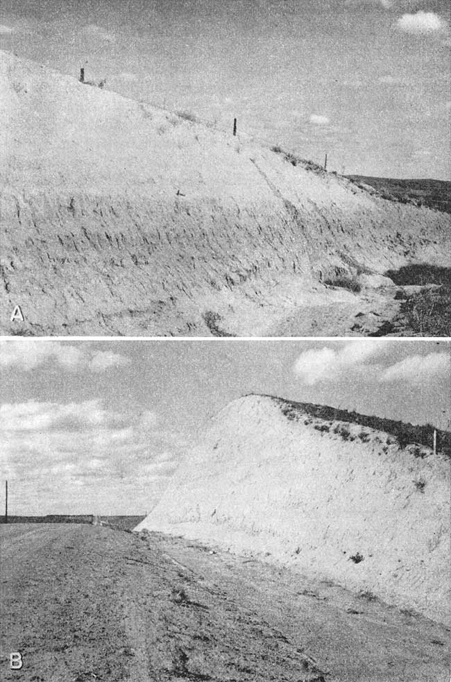
The Peoria silt member is the most widespread member of the Sanborn in Cheyenne County. The Peoria consists mainly of tan to light-brown silt and very fine sand (Pl. 7B). Locally, however, it contains large amounts of fine to coarse sand, as in test holes 1-37-8acd and 5-39-6aaa. The sandy deposits are continuous with the silt, no definite boundary existing between them. Therefore, this sand is probably a sandy phase of the Peoria representing periods of high wind during Sanborn rather than more recent time.
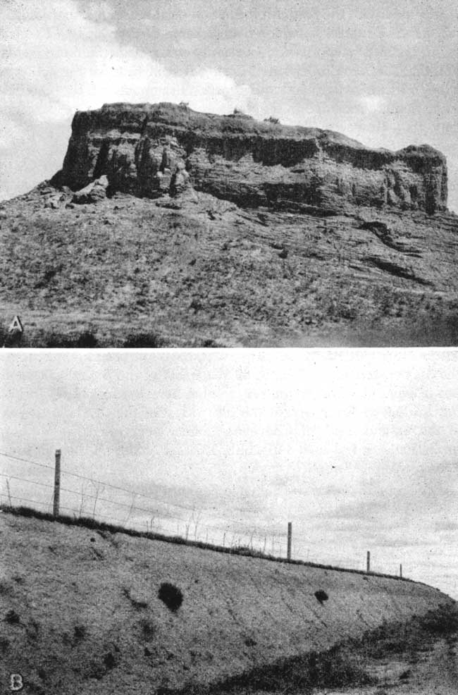
Plate 8A shows a deposit of fine to coarse sand in the Peoria. This sand deposit has been protected from erosion by a sod cover and a thick black soil and now has the appearance of a small isolated butte.
Plate 8--A, Butte of a sandy phase of the Peoria silt member of the Sanborn formation. Butte is protected from erosion by sod cover and soil. NW sec. 17, T. 1 S., R. 37 W. B, Peoria silt member of the Sanborn formation overlain by thin Brady soil and thin Bignell silt member. NW sec. 11, T. 1 S., R. 40 W.
The Bignell silt member, the youngest member of the Sanborn formation, has been identified in only a few places in Cheyenne County. The silt is exposed at one locality in the SE cor. sec. 28, T. 3 S., R. 39 W., in a road cut along U. S. Highway 36, where it overlies the Brady soil, which is developed on the Peoria silt. Other exposures of the Bignell silt member are in the NW sec. 11, T. 1 S., R. 40 W. (Pl. 8B), and in the NW NW sec. 23, T. 2 S., R. 40 W. Included with the Sanborn formation on the geologic map (Pl. 1) are colluvial materials, which mantle some of the slopes. The colluvium or slope deposits consist mainly of silt of the Sanborn formation that has been redeposited during Recent time by the action of wind, surface water, and soil creep. Fragments of the Ogallala formation are included in some places in the lower part of the slope deposits. However, slope deposits are generally indistinguishable from the Sanborn formation and are mapped with it.
Distribution and thickness--As indicated by Plate 1, the Sanborn formation and slope deposits underlie the surface of nearly all of Cheyenne County. According to Elias (1931, p. 163) 180 feet of loess is exposed in canyons in the NW sec. 20, T. 1 S., R. 41 W., the type locality of the Sanborn. In sec. 17, T. 1 S., R. 41 W., just north of the type section designated by Elias, J. C. Frye and Norman Plummer (personal communication) measured 130 feet of Sanborn above the Pierre shale. Of this amount 90 feet is Peoria silt, 6 feet is Sangamon soil and Loveland silt, and 34 feet is Crete sand and gravel. The upper part of the section is covered and the Bignell silt member and Brady soil, if present, have not been identified. In the SE cor. sec. 28, T. 3 S., R. 39 W., 5 feet of the Bignell silt member is exposed. The Peoria silt member here is 8 feet thick, including 1.5 feet of Brady soil at the top. Most of the test holes drilled in the upland areas of Cheyenne County penetrated the Sanborn formation. In test hole 3-37-1bbb, 132 feet of silt, all thought to be Peoria, was penetrated.
Age and correlation--The name Sanborn formation was first used by Elias (1931, p. 163) to replace such terms as "Tertiary marl" or "Plains marl" used by Hay (1895) and other early geologists in the central Great Plains region for deposits later recognized as consisting mainly of loess. Elias considered these deposits to be Pleistocene in age. Lugn (1935, p. 197) objected to the use of the term Sanborn formation because the terms Loveland formation and Peorian formation had already been used for several years in Nebraska for deposits in Nebraska that be considered equivalent to the Sanborn. Also, the term Sanborn was taken from the name of a small town in southwestern Nebraska where Peorian loess was recognized. In 1937 Elias (1937, p. 7) noted the occurrence of a dark-brownish ("red") loess that underlies the light yellowish-buff Sanborn loess in Decatur County. He classed this "red" loess as equivalent to the Loveland formation in Nebraska. The Loveland, Peoria, and Bignell silt members of the Sanborn formation are now correlated with the Loveland, Peorian, and Bignell loesses of Nebraska (Frye and Fent, 1947). The Crete sand and gravel member is considered Illinoian in age, the Loveland silt member is Illinoian and early Sangamonian, the Peoria silt member is Iowan and Tazwellian, and the Bignell silt member is Mankatoan and Caryan in age (Moore and others, 1951).
Water supply--The Sanborn formation generally lies above the water table in Cheyenne County and does not yield water to wells. However, in the northern part of the county where the Sanborn is thick, the Ogallala thin, and the water table discontinuous, small quantities of highly mineralized water can be obtained in some of the canyons eroded in the loess. Several wells, for example 1-38-23cbb and 1-41-23acc, obtain water from the Sanborn formation, probably the Crete sand and gravel member, or from colluvial deposits. The Sanborn, because of its fine texture and low permeability not only is unimportant as a water bearer but also generally retards greatly the recharge of ground water to aquifers below it.
Dune Sand
Deposits of dune sand lie south of South Fork for much of its extent across Cheyenne County. The dune sand is composed predominantly of fine to coarse sand which has been accumulated by the wind to form small hills. Most of the sand hills are vegetated, but in some spots, such as in road cuts, areas of bare sand are being subjected to renewed wind action. The dune sand probably was derived mainly from alluvial deposits along South Fork and to a lesser extent from sands in the Ogallala, and was blown a short distance to its present location during Recent time. The maximum thickness of the dune sand is not known but probably does not exceed 15 or 20 feet.
No wells in Cheyenne County are known to obtain water from the dune sand, but the dunes, because of their high permeability, are good intake areas for ground-water recharge from local precipitation.
Alluvium
General features--Deposits of Recent alluvium lie along the valleys and underlie the flood plains of South Fork and Arikaree River and some of the small creeks. The alluvium along South Fork and Arikaree River consists mainly of sand and gravel with lesser amounts of silt and clay. Alluvial deposits along Little Beaver Creek contain a relatively large amount of sand and gravel derived from the Ogallala formation, but the valleys of Beaver, Hackberry, Big Timber, and other small creeks contain large amounts of silt and fine sand derived from the Sanborn formation and slope deposits. The major streams in Cheyenne County are not actively eroding at present but serve as transportation lines for the fine sediments carried into the streams from the upland areas by tributaries that flow after periods of heavy rain and do a small amount of erosive work.
The areal extent of the alluvial deposits is shown on Plate 1. Included with the alluvium along South Fork are scattered remnants of terrace deposits. These deposits of older alluvium are discontinuous and cannot be mapped as units in Cheyenne County. The thickness of the alluvium along South Fork where penetrated in test holes ranged from 14 to 37 feet. The thickness of alluvial deposits in the other valleys was not determined, but it probably is somewhat less than the maximum figure for South Fork, and its texture is, on the average, finer grained.
Water supply--Next to the Ogallala formation the alluvium of South Fork is the most important water-bearing formation in Cheyenne County. The alluvium supplies water to the St. Francis municipal wells, to several irrigation wells, and to many domestic and stock wells. The yields of wells deriving water from the alluvium range from a few gallons a minute for domestic and stock wells to a few hundred gallons a minute for some of the irrigation wells. The alluvium along Arikaree River and Beaver Creek yields water to only a few wells in Cheyenne County because of its limited areal extent. Along some of the tributaries to Arikaree River and South Fork there is some water in alluvial and colluvial deposits, but the alluvium of Little Beaver Creek lies above the water table and does not yield water to wells. Water in alluvial deposits in Cheyenne County is of poorer quality than that in the Ogallala formation; it generally is considerably higher in dissolved solids and in hardness than is water from the Ogallala.
Prev Page--Chemical Character || Next Page--Well Records
Kansas Geological Survey, Geology
Placed on web Aug. 8, 2008; originally published April 1953.
Comments to webadmin@kgs.ku.edu
The URL for this page is http://www.kgs.ku.edu/General/Geology/Cheyenne/06_form.html